43
IN SITU MEASUREMENT OF THE SOIL MOISTURE
CONTENT PROFILE AT A DECOMPOSED GRANITE
CUT-SLOPE
Adrin Tohari and Makoto Nishigaki
ABSTRACT Two selected sites at a
decomposed granite cut-slope were instrumented with a rain gauge and a series of ThetaProbes
installed at depths up to 90 cm from the slope surface. The objective of this study was to evaluate the significance of antecedent soil moisture conditions in controlling the hydrologic responses of the soils at each site. The antecedent moisture content of the soil in Site #1, in general, increases with depth. The response of the soil to saturation process is more or less confined to the shallow depth. On the other hand, the measurement data of the soil in Site #2 showed that the near surface soil exhibits higher antecedent moisture condition than the deeper soil. The ingress of the wetting front could reach more than 90 cm depth during long period of rainfall. Thus, these results suggest that the hydrological response of the soils is spatially variable and is influenced by the antecedent soil moisture conditions within the soil profile. The presence of soil layers, the distribution of macro cracks within the soil profile, and additional lateral source of moisture may also have significant influences on soil response to saturation process.
Keywords : antecedent moisture content, hydrological response, field instrumentation, rainfall, rainfall infiltration, soil moisture content
Naskah masuk: 21 Januari 2010 Naskah diterima: 10 Maret 2010 Adrin Tohari
Research Center for Geotechnology, Indonesian Institute of Sciences, Bandung 40135
Email :[email protected]
Makoto Nishigaki
Faculty of Environmental Science and Technology, Okayama University, Okayama, Japan
ABSTRAK Intrumentasi lapangan untuk
pemantauan curah hujan dan kadar air (moisture content) tanah dilakukan pada dua lokasi di suatu lereng potongan yang tersusun oleh granit yang telah terlapukkan. Instrumentasi terdiri dari sejumlah sensor kadar air tipe ThetaProbes
yang dipasang hingga kedalaman 90 cm dari permukaan tanah dan alat takar hujan otomatis tipe tipping bucket. Sasaran dari studi ini adalah untuk mengevaluasi pentingnya kondisi
antecedent soil moisture dalam mengontrol respon hidrologis tanah di setiap lokasi. Hasil pemantauan selama periode hujan menunjukkan bahwa pada umumnya, kondisi antecedent moisture content tanah pada lokasi #1 meningkat menurut kedalaman. Respon tanah terhadap proses penjenuhan hanya terbatas pada lapisan tanah dangkal. Di lain pihak, data pengukuran pada lokasi #2 menunjukkan bahwa lapisan tanah dekat permukaan cenderung memperlihatkan kondisi antecedent moisture content yang lebih tinggi dari pada lapisan tanah yang lebih dalam. Infiltrasi air hujan dapat mencapai kedalaman lebih dari 90 cm selama periode hujan yang lama. Dengan demikian, hasil studi ini menunjukkan bahwa respon hidrologis lereng tanah ini bervariasi secara spasial, dan dipengaruhi oleh kondisi antecedent soil moisture dalam profil tanah. Keberadaan pelapisan tanah dan distribusi rekahan dalam profil tanah serta sumber-sumber aliran
moisture juga mempunyai pengaruh yang penting pada respon tanah terhadap proses penjenuhan.
Kata kunci : antecedent moisture content, curah
44
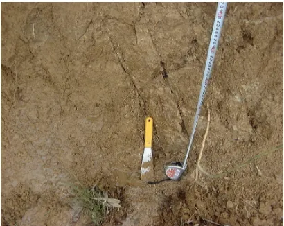
Figure 1. Location of pre-existing cracks within the weathered granite.
INTRODUCTION
Many steep residual slopes are susceptible to landslide during or immediately following heavy rainfall. Because the failures often mobilize into debris flow capable of traveling large distances, they pose significant hazards to human lives and infrastructures.
In order to understand the hydrologic condition leading to landslide initiation, numerous studies have focused on the hydrologic response of a soil slope to rainfall (Johnson and Sitar, 1990; Anderson and Thallapally, 1996; Fannin and Jaakkola, 1999). Their studies indicate that the hydrologic response of soil slopes to rainfall was highly dependent on antecedent moisture conditions, and tends to be influenced by site-specific conditions. This paper presents the results of a field instrumentation program aimed at monitoring the hydrologic response of a decomposed granite cut-slope in Okayama, Japan. The monitoring program was carried out on a stable slope portion and above a recent failure main scarp. For the purpose of evaluating the importance of antecedent moisture conditions, the instrumentation used was capable of performing direct monitoring of volumetric water content conditions in response to rainfall. Given to the remote nature of location, the instrumentation was manufactured for automated data acquisition. Specific objectives of the study were to (i) identify the typical characteristics of hydrologic response of each slope portion, (ii) evaluate the importance of antecedent moisture condition in hydrologic response of each slope portion, and (iii) contrast factors controlling the hydrologic response of the slope.
MATERIALS AND METHODS
Site Characteristics
The instrumented site is located in the north of Okayama city, Japan. The slope has an angle of
55 degrees and is approximately 9 m high. During a significant period of rainfall event in June 2001, a landslide occurred on the lower boundary of recent cut-slope, involving 1.5 m thick of decomposed granite. One week prior to the event, moderate rainfalls occurred in this site, resulting in an antecedent total precipitation of 45 mm. The onset of 20-hour rainfalls occurred between 19 and 20 June, with a total precipitation of 94.5 mm and maximum intensity of 9.5 mm/hr. Although a precise time of failure was unknown, the failure is likely to occur during this sustained period of heavy rainfall.
45
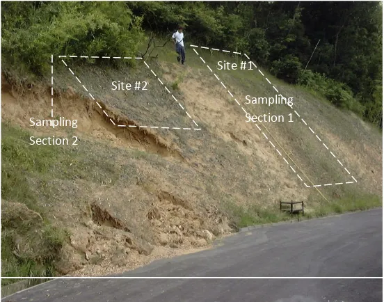
Site #2
Site #1
Sampling Section 2
Sampling Section 1
Figure 2. Locations of sampling and instrumentation.
Undisturbed soil samples were collected from both failed and stable slope portions (Fig.2). The soils taken from the stable slope portion (Site #1), were characterized by higher degree of saturation of deeper soils (75-87%) compared with shallower soil (58-65%). The in-situ porosity of the soils is not uniformly distributed, ranging between 36% and 38.5%. Meanwhile,
the soils taken from the unstable slope (Site #2) were characterized by higher degree of saturation of shallower soils (85-88%) compared to deeper soils (81%). The porosity of the soils varies with depth, ranging from 36% to 40%. Tables 1 and 2 show the summaries of the soil properties for each site.
Table 1. Physical properties of soils in Site #1 prior to sensor installation
Depth of sampling (m)
Soil Properties 0.25 0.45 0.9 1.32
Porosity, n (%) 38.2 37.8 36.3 39.8
Saturated moisture content, θsat* 0.38 0.38 0.36 0.40
Bulk unit weight (Mg/m3) 1.76 1.49 1.49 1.49
Degree of saturation, Sr (%) 55 65 75 87
* calculated from porosity
Table 2. Physical properties of soils in Site #2 prior to sensor installation
Depth of sampling (m)
Soil Properties 0.2 0.4 0.6 0.8 1.0 1.2
Porosity, n (%) 37.9 40.5 38.2 38.8 38.9 40.5
Saturated moisture content, θsat* 0.38 0.41 0.38 0.39 0.39 0.41
Bulk unit weight (Mg/m3) 1.86 1.83 1.83 1.83 1.97 1.87
Degree of saturation, Sr (%) 88 85 86 81 82 83
46
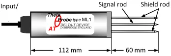
Figure 3. Schematic diagram of ThetaProbe
sensor. Field Instrumentation
A detailed instrumentation scheme was implemented to monitor the variation of moisture content with time and precipitation. The instrumentation consisted of a series of soil moisture content sensors, a rain gauge, and an automatic data-acquisition system.
1. Moisture content measurement
Because of their reliability, precision and ease of use with free maintenance for long-term measurement of soil volumetric moisture content, two ML1 and five ML2x-UM1.21 ThetaProbe sensors manufactured by Delta T Devices were used in this study (Fig. 3). This type of instrumen has proven very effective in other studies of soil moisture conditions in-situ (e.g., Miller and Gaskin, 1997).
A hole was created perpendicular to the slope surface for each ThetaProbe sensor using a 5.6 cm diameter hollow tube. The tube was driven perpendicular to the slope surface into the ground to a depth about 6 cm less than the depth of measurement point. The ThetaProbe sensor was inserted in the hole, and pushed 6 cm into the soil. An extension tube was used to ease installation at the depth greater than 10 cm. Care was taken not to exert excessive forces during the insertion, which could cause bending in the rods. Upon the completion of the installation, a gypsum seal was poured into the space around the probe body and extension tube to prevent any surface water from running down the probe shaft.
2. Precipitation measurement
A tipping-bucket rain gauge housed within an aluminum cylinder calibrated to measure rainfall in increment of 0.5 mm was used to monitor
precipitation. The gauge had an orifice diameter of 20 cm and was elevated approximately 75 cm above the ground surface. Care was taken to place the rain gauge so that obstruction would not influence precipitation measurements. The gauge was located at the bench of the stable slope right to the failure zone about 6.5 m from the slope toe.
3. Data acquisition system
The data-acquisition system is solar powered and capable of continuous monitoring and remote downloading of data. The data logger was set to record and store moisture content and comparative precipitation data every 10 minutes. The data were automatically downloaded into a contactless memory card and were collected from the field site every 10 days.
Instrumentation Lay-Out
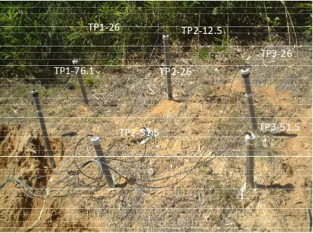
1. Site #1 (stable slope portion)
During the summer heavy rainfall of 2001, the monitoring program was focused on a stable slope portion of the cut-slope. Two ThetaProbe nests were installed along a section of the lower portion of the stable cut-slope. Each nest consisted of a group of ThetaProbe sensors installed within 1 m radius to different depths (Fig. 4). The objective was to identify any difference in magnitude and timing of the response along the slope profile.
47 TP2‐51.5
TP2‐12.5
TP2‐26
TP1‐76.1 TP1‐26
TP1‐51.5
TP1‐12.5
Figure 4. Configuration of ThetaProbe sensors in Site #1.
TP1‐26
TP1‐76.1
TP2‐12.5
TP2‐26
TP2‐51.5
TP3‐26
TP3‐51.5
Figure 5. Configuration of ThetaProbe sensors in Site #2. 2. Site #2 (above the failure scarp portion)
Seven ThetaProbe sensors were installed above the main scarp at three closely spaced nests within 75 cm radius in various depths on 3 October 2001 (Fig. 5). The data were collected from these instruments through 21 January 2002. The objectives were to monitor the difference in magnitude and timing of the post-failure response with depth, and to compare the response across a relatively short distance.
One sensor (TP1) was installed in nest 1 at the depth of 26 cm, and three sensors in nest 2 and
48
0
60
120
180
240
300
360
0
4
8
12
16
20
24
12-Jul
28-Jul
13-Aug
29-Aug
14-Sep
30-Sep
R
ai
n
fal
l (mm)
R
ainf
al
l int
ens
it
y
(
m
m
/h)
Date
I (mm/hr)
R (mm)
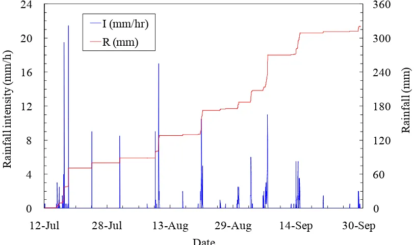
Figure 6. Rainfall characteristic for the period of 12 July to 30 September 2001. RESULTS OF FIELD MONITORING
Rainfall Characteristics
(1) Record of 12 July-30 September 2001
The precipitation record collected during the 2.5-month monitoring period indicates that a total precipitation of 321 mm fell on site; and the majority of the rainfall events occurred within one-month period, i.e. between 9 August and 15 September, with a total precipitation of 220.5 mm (Fig. 6).
The July to mid-August period was characterized by high-intensity rainfalls of short duration. Heavy rainfalls were recorded on 17 and 18 July, and 10 August fell at an intensity exceeding 15 mm/hr, and lasted for less than three hours. Rainfalls with longer duration began to occur in the site from the last 10 days of August 2001. A rainfall of 42.5 mm consisting of two pulses occurred in 16 hours on 21 August at a maximum intensity of 10.5 mm/hr. A total precipitation of 62.5 mm fell during 6-7 September, at a maximum intensity of 11 mm/hr. The 14-15
September rainfall was characterized by three pulses of 5-hour rainfalls of a total precipitation 37.5 mm.
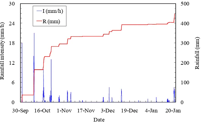
(2) Record of 1 October 2001- 21 January 2002
These months illustrate well the transition of the rainfall pulses from high to low precipitation and intensities. The record shows that this four-month rainfall events dropped a total precipitation of 447 mm in the field site, most of which occurred during the October period (Fig. 7).
49
0 100 200 300 400 500
0 6 12 18 24 30
30-Sep 16-Oct 1-Nov 17-Nov 3-Dec 19-Dec 4-Jan 20-Jan
R
ainf
all (
m
m
)
R
ai
n
fa
ll i
n
te
ns
it
y
(
m
m
/h)
Date I (mm/h)
R (mm)
Figure 7. Rainfall characteristic for the period of 1 October 2001 to 21 January 2002.
Table 3. Porosity of the soil at each sensor location in Site #1
Sensor No. TP1 TP2
Depth (cm) 12.5 26 51.5 76.1 12.5 26 51.5
Porosity, n (%) 43 41 40 38 41 39 38
Table 4. Porosity of the soil at each sensor location in Site #2
Sensor No. TP1 TP2 TP3
Depth (cm) 26 76.1 12.5 26 51.5 26 51.5
Porosity, n (%) 39 40 39 39 38 39 39
The third rainfall pulse dropped 67 mm of rain in 32 hours between 16 and 17 October, with a single burst at an intensity of 10 mm/hr, occurring 10 hours after the start of the rain. The last pulse of the October rainfall fell between 21 and 22 October, resulting in a cumulative precipitation of 52 mm in 37 hours. In contrast to the October events, rainfalls of lower intensities and shorter durations characterized precipitation events from November 2001 to January 2002. The November events consisted of two significant rainfalls of 30, and 10 mm, occurring during 3 and 6 November, with maximum intensity not exceeding 3.5 mm/hr. Rainfalls varying from 10 mm to 30 mm fell at the site between 4 and 13 December. With the onset of
winter rainfall period, a heavy rain dropped a total of 42.5 mm of rain at an average intensity of 2.5 mm/hr during 20-21 January 2002.
Site Hydrological Response
50
15-Aug 24-Aug 2-Sep 11-Sep 20-Sep 29-Sep
Date
15-Aug 24-Aug 2-Sep 11-Sep 20-Sep 29-Sep
Date
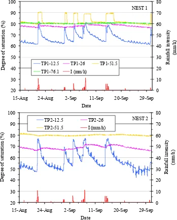
Figure 8. Hydrologic response of soils in Site #1 to saturation process for Nests 1 and 2 (15 August-30 September).
(1) Hydrologic response of Site #1
The response of the instruments to saturation process in the two nests is presented in Figure 8 along with a plot of the hourly rainfall intensity for all rainfall events. The initial degree of
51 Comparing the response data between the two
nests, a marked distinction between the antecedent moisture condition of nest 1 and 2 is evident. The instruments in nest 1 recorded higher initial degree of saturation than the corresponding instruments in nest 2, indicating that the soil profile at nest 1 appears to have wetter antecedent condition prior to every significant rainfall event than the soils upslope of this nest. Therefore, the response of the soil in nest 1 is more rapid than in nest 2. The response of these instruments shows that the saturation of near surface soils increases more sharply and rapidly than most of deeper soils. However, it is evident in Figure 8 that the intermediate instrument in nest 1 (TP1-51.5) also responded to short but high intensity rainfall events slightly after the shallowest instrument (TP1-12.5) in similar form, while the shallower and deeper instruments (TP1-26 and TP1-76.1) generally did not. The fast response of the intermediate sensor suggests that rainwater infiltrated through a preferential moisture movement such as fractures or macropores in the soil profile, as evidence from field observation on failure main scarp (See Fig. 1).
It is also interesting to note that the deepest instrument shows the shortest duration of response, suggesting that the vertical source of moisture contributed less significantly to the deeper part of the soil profile, due to the interception of moisture migration by the higher permeable soil in association with the pre-existing crack at the shallower depth; thus, limiting moisture movement further to the greater depth.
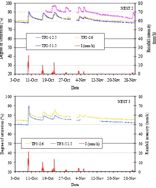
(2) Hydrologic response of Site #2
Due to the poor response of sensor TP1-76.1, the response of instrumentation in nest 1 is not presented in this paper. The response of the instruments to the saturation process in the nests 2 and 3 is presented with hourly rainfall intensity for all rainfall events for the period 3 October-29 November in Figure 9. At the beginning of the
monitoring period, the initial degree of saturation throughout the soil profile varies from 70 to 80% with the highest values being recorded in the shallow instruments in all nests.
Referring to Figure 9, the initial degree of saturation decreases from nest 2 to nest 3 at the corresponding depths, indicating that the soil profile at nest 2 appears to have the wettest antecedent condition prior to every significant rainfall event. The soil samples taken from each sensor location revealed that the soils at each nest have similar porosity (See Table 4). Thus, an additional source of moisture could be present close to nest 2 to maintain the antecedent moisture condition in this soil profile.
The response to October rainfall and November rainfall events is obviously not confined to shallow part of the soil profile in all nests. The wetting front was observed to advance to a greater depth. In addition, most rainfall events during these periods have caused the near-surface soil to achieve a nearly full saturation.
52
3-Oct 11-Oct 19-Oct 27-Oct 4-Nov 12-Nov 20-Nov 28-Nov
Date
3-Oct 11-Oct 19-Oct 27-Oct 4-Nov 12-Nov 20-Nov 28-Nov
Date
TP3-26 TP3-51.5 I (mm/h)
NEST 3
Figure 9. Hydrologic responses of soils in Site #2 to saturation process (3 October 2001- 29 November).
DISCUSSIONS
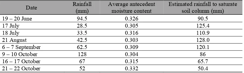
Significance of Antecedent Moisture Content The following discussion shows how a simple analysis can be used to assess the significance of the antecedent moisture content. Considering a soil column of the stable slope portion in the vicinity of nest 1, a vertical soil depth of 1.32 m, and saturated moisture content of about 0.4 (See Table 1), the amount of water required to saturate
53 Table 5. Characteristics of rainfall monitored during the period of June-October 2001.
Date Rainfall
(mm)
Average antecedent moisture content
Estimated rainfall to saturate soil column (mm)
19 – 20 June 94.5 0.326 90.5
Based on these calculations, none of the monitored rainfall would saturate the soil column (Table 5). Similarly, for a soil column above the main scarp with the depth of approximately 0.9 m, and saturated moisture content of about 0.388 (See Table 2), the amount of water needed to saturate the soil column is equal to a total rainfall less than 75 mm for an antecedent moisture content higher than 0.3. Under these soil conditions, all the monitored October rainfalls appear to be higher than the estimated rainfalls, and would have saturated the soil column. However, the response of the deep instrument in nest 2 indicates that the corresponding soil never reached full saturation during the October rainfall events. These inconsistencies, indeed, are due to the simplification of the slope hydrology. Thus, the estimation of the amount of rainfall needed to saturate a particular slope profile considers not only a vertical infiltration alone, but also lateral component of flow.Assuming that the antecedent moisture content prior to 18 June rainfall was about 0.309, the 18 June rainfall of 23.5 mm could increase a moisture content of the 1.5 m thick of soil to 0.324. Thus, the rainfall required to saturate a 1.5 m soil column in Site #2 during the 19-20 June 2001 is about similar to the monitored rainfall event (See Table 5). Thus, the antecedent rainfall prior to the 19-20 June rainfall could be considered to have introduced the required antecedent moisture content for the landslide to take place. This illustrates the significance of the antecedent moisture condition in controlling the hydrologic condition leading to landslide initiation.
Factors Controlling the Site Hydrologic Responses
54
CONCLUSIONS
A cut-slope of weathered granite was instrumented with a number of soil moisture content sensors to the hydrologic response of the slope to rainfall. The results of a 6-month field-instrumentation program have been used to identify the typical characteristics of the hydrologic response of the slope soil to rainfall and to assess the significance of antecedent soil moisture condition in controlling the hydrologic response of the soil slope. In general, the hydrologic response of the soil is also closely related to the characteristics of rainfall events.
The observed moisture content data for the period of July-September 2001 indicates that the antecedent moisture content of the stable slope soil was lower for the near surface soil than the deeper soil. In general, the antecedent moisture condition increases with depth. The lower portion of the slope tends to have higher antecedent moisture condition than the upper portion. Consequently, the lower portion of the slope exhibits more rapid and more sustained response to saturation process than the upper portion. While the increase of saturation in the lower slope soil could develop at the greater depth, the response of the upper slope soil to saturation process is more or less confined to the shallow depth. These data could suggest that the downslope moisture migration is more dominant than the downward migration in the upper slope soil. The response data also show that the upper slope soil require shorter period to dissipate the increased saturation than the lower soil. As far as the stability of the slope is concerned, therefore, it is necessary to monitor the development of saturation in this lower area.
The moisture content data of the soil above the main scarp for the period of October-January show that the shallower soil exhibits the higher antecedent moisture condition than the deeper soil; and the antecedent moisture condition is lower for the soil further away from the main scarp. The observed soil response to infiltration shows that the near surface soil could reach full saturation. In contrast to the stable slope (Site #1), the soil in the failure area has a slower
response time in association with the lower antecedent moisture condition. The ingress of the wetting front could reach more than 90 cm depth during long period of rainfall.
The role of the antecedent soil condition on the hydrologic response of the soil slope has been demonstrated by using the data collected during this study. While the antecedent soil condition has been previously reported in terms of total precipitation and pore-water pressure, the antecedent moisture condition can be directly obtained and assessed using the soil moisture content sensors, such as ThetaProbe sensor. However, this method requires a good method for the determination of soil porosity in order to obtain the corresponding degree of saturation.
The hydrological response of the soil slope observed during this study indicates that the conceptual model of hillslope hydrology is oversimplified. The conceptual model cannot explain the spatial and transient variation of responses over short distance across and along the slope. The presence of highly permeable zone due to fractures within the soil profile and the additional lateral source of moisture also influence soil response to a saturation process.
REFERENCES
Anderson, S.A., and Thallapally, L.K. (1996). “Hydrologic response of a steep tropical slope on heavy rainfall.” Proc. 7th Int. Symp. on Landslides, A.A.Balkema, Rotterdam, The Netherlands, Vol. 3, 1489-1495.
Fannin, R.J., and Jaakkola, J. (1999). “Hydrological response of hillslope soils above a debris-slide headscarp.” Can. Geotech. J., 36, 1111-1122.
Johnson, K.A., and Sitar, N. (1990). “Hydrologic conditions leading to debris flow initiation.” Can. Geotech. J., 27 (6), 789-801.