Tamale
Burkina FAso
T
ogo
Iv
o
r
y C
o
a
st
Accra
Takoradi
Kumasi
Integrated Coastal and Fisheries Governance Initiative
Integrated Coastal
Management Toolkit
coastal resources
This publication is available electronically on the Coastal Resources Center’s website at http://www.crc.uri.edu.
For more information contact:
Acknowledgements
With funding from the United States Agency for International Development (USAID), the Coastal Resources Center of the Graduate School of Oceanography at the University of Rhode Island have worked together with core partners including
Friends of the Nation, Worldish and Sustainametrix
to implement the Integrated Coastal and Fisheries Governance (ICFG) Initiative, locally known as Hen Mpoano. We are pleased to compile a compendium of Integrated Coastal Management (ICM) information and knowledge generated through this 4-year Initiative into a toolkit to inform district level planning and management of coastal and marine resources. Compilation of this
material beneited from the contributions of a large
number of colleagues and practitioners, including many members of the coastal communities of the Western Region of Ghana and beyond, who have assisted in information gathering, research and analysis. We sincerely acknowledge the
contribution of the planning departments of the six
coastal districts of the Western region in supporting the development of innovative processes that builds ICM into district planning processes and decision making procedures. We are also grateful to the following individuals for providing technical insights and guidance during the production of
Please cite this report as:
Coastal Resources Center (2013). Shama District Integrated Coastal Management Toolkit. Integrated Coastal and Fisheries Governance Initiative (Hen Mpoano) Narragansett, RI: Coastal Resources Center at the Graduate School of Oceanography, University of Rhode Island 62 pp
Disclaimer:
This publication is made possible by the generous support of the American people through the United States Agency for International Development (USAID)/Ghana. The contents are the responsibility of the authors as part of the Integrated Coastal and Fisheries Governance (ICFG) Initiative and do not
necessarily relect the views of the United States Government. Associate Cooperative Agreement No.
641-A-00-09-00036-00 for “Integrated Coastal and Fisheries Governance (ICFG) Program for the Western Region of Ghana,” Under the Leader with Associates Award No. EPP-A-00-04-00014-00.
Cover photo: Fort San Sebastian, Shama Photo credit: Lucia Rybarova
Coastal Resources Center
University of Rhode Island, Narragansett Bay Campus 220 South Ferry Road
Narragansett, Rhode Island 02882 USA
Brian Crawford, Director of International Programs Email: [email protected] Tel: 401-874-6224
Fax: 401-874-6920
Friends of the Nation
http://www.fonghana.org [email protected]
P.O Box MC 11
Takoradi, Western Region, Ghana
Hen Mpoano
http://www.henmpoano.org
P.O. Box AX 296
Takoradi Western Region Ghana
this material: Dr. Christopher Cripps (Spatial Solutions), Dr. Donald Robadue (Coastal Resources Center, University of Rhode Island, USA), Stephen Kankam (Hen Mpoano), Pamela Rubinoff (Coastal Resources Center, University of Rhode Island, USA), Hillary Stevens (Coastal Resources Center,
University of Rhode Island, USA) and Koi Agbogah
(Hen Mpoano). The graphic designs and layouts as well as GIS mapping have been done through the hard work of Justice Camilus Mensah (Hen Mpoano) and Lucia Rybarova (Oil City Magazine).
Finally, we would like to acknowledge the fruitful
collaboration developed with key oficials and
institutions, without which this toolkit will not have been possible. At the regional level the partnership
developed with the Members, Chief Executives, Directors and Oficers of the District Assemblies,
Statement from Honourable
Enoch K. Appiah, District Chief
Executive of the Shama District
Assembly
This toolkit is obviously a carefully designed and well-structured piece, which a young district such as ours needs as guidance for coastal planning and decision making. I am truly grateful to the Hen Mpoano Initiative for this level of support.
Since the beginning of the Initiative in 2009, Coastal Resources Center and partners have been supporting the Assembly to manage the overwhelming coastal issues facing the district. In Hen Mpoano’s area of operation which covers all
six coastal districts, Shama District can boast of
being the lead in terms of preparing spatial plans, adopting policies and piloting integrated coastal management approaches. This toolkit complements other efforts being carried out by the government to counter and avoid all the potentially destructive and harmful challenges faced by the coast. .
This Toolkit has put together the rich indings and
lessons learned since 2009-2013 and provide the requisite tools developed at the time for all of us to tackle the problems in the coastal zone and take advantage of the emerging opportunities and modern technologies that are available to us. It also serves as a useful tool for mainstreaming coastal management into development plans and programmes of the district assembly. I therefore recommend it for all institutions, bodies and groups investing and working at the coast.
CHIEF EXECUTIVE,
SHAMA DISTRICT ASSEMBLY
5
lood and drought), causing
sea levels also to rise.
Community Resourced Management Areas (CREMA): creates a win-win situation by creating a
inancial incentive for farmers
to use and manage natural resources on sustainable basis by devolving management rights and responsibilities to them.
Development: is any man-made alteration to the landscape including grading,
illing, dredging, extraction,
storage, subdivision of land, or construction of structures, stormwater collection, drainage and discharge
works, lood protection
works.
Ecosystem: a complex set of relationships among the living resources, habitats and residents of an area. It includes plants, trees,
animals, birds, ish,
micro-organisms, water, soil and people. Everything that lives in an ecosystem is dependent on the other species and elements that are part of that ecological community.
Eco Tourism: is a a form of tourism involving visiting fragile, pristine, and relatively undisturbed natural areas, intended as a low-impact and often small scale alternative to standard commercial (mass) Adaptive Capacity: capacity
of a community to adapt itself to the threats and hazards such as climate change, coastal erosion, loss of livelihoods and inappropriate development.
Artisanal Fishing leet:
traditional canoe-based
ishing vessels.
Barrier spit or beach: sandy beaches built up by ocean wave energy and backed by wetlands or river
outlows. These systems are
in constant movement in response to the energy of the surrounding system.
Built Areas Highly
Exposed to Flood Damage: are settlements, businesses, residences and public
buildings which are routinely
submerged by lood waters,
erosion or damage from high velocity stream and drainage
low.
Carbon Sequestration: the
absorption of carbon dioxide
(a “greenhouse gas” which is responsible for global warming) by vegetation.
Catchment Area The area receiving the waters feeding a part or the totality of a watercourse or watershed.
Climate Change: the changes in climate which are
being experienced, including extremes of weather (storms,
Definitions
tourism. Its purpose may be to educate the traveler, to provide funds for ecological conservation, to directly
beneit the economic
development and political empowerment of local communities, or to foster respect for different cultures and for human rights. Ecological goods and services: are the beneits provided by wetlands e.g.,
water puriication, supplies of portable water, ishes,
plants, building materials and water for livestock, outdoor recreation and education.
Environmental
Assessment: is the process of identifying, predicting, evaluating and mitigating the biophysical, social, and other relevant effects of development proposals prior to major decisions being taken and commitments made.
Erosion: is the removal and transportation of soil particles by the action of water, wind, gravity or other geographical agents, whether naturally occurring or acting in conjunction with or promoted by man - made activities or effects.
Estuary: means a body of surface water a) that is part of a water course that permanently or periodically opens to the sea b) in which the salinity is measurably
higher as a result of the
inluence of the sea.
Flood: an overlow of rain water or other sources along
the normal conines of a
river, stream, drainage way or other water body that causes or threatens damage to property, infrastructure, people, or natural resources.
Flood prooing or
protection: means any combination of structural and non-structural additions, changes, or adjustments to
existing or new structures
which reduce or eliminate
lood damage to residential
and non-residential buildings and their contents. These can include protective walls and drainage systems to redirect water away from
existing buildings, rebuilding
structures to make them more resistant to the
intrusion of lood waters
or the physical force of high velocity water. It also includes special design and construction techniques including piers and elevating
the lowest usable loor of a
building above the level of
water experienced in events.
Floodplain: a level or nearly level land along a
stream or river looded only when the stream low exceeds the water carrying capacity of the channel. lat or nearly lat land adjacent
to a stream or river that
experiences occasional or periodic looding.
Green Belt: an area which has been designated around a settlement for no development in order to provide access to green and open spaces and to encourage more dense urbanization.
High tide line: is the highest point on the shore that is covered by water at high tide. Ghana has two high tides and two low tides each day. The mean tidal range (distance between high and low tides) is 1 meter, and the spring tidal range (time of new or full moon) is 1.3m. For purposes of coastal development, this is the line which development is set back from.
Lagoon: closed or open, a shallow body of water separated from the ocean by a barrier island or spit. It may be open to the ocean occasionally during seasonal
looding or high seas.
Pair Trawling: the joining of nets to two boats in order to increase catches.
Pocket beach: a short sandy shoreline between rocky headlands that prevent long shore transport of sediment.
Restoration: is a broad process of reversing physical, economic and social decline in a coastal area.
Set back: is an area left free of any physical development
or modiication, commonly
used to setback structures from a coastal feature, or from a road in an urban area.
Shoreline protection structures, or sea defense structures:
include breakwaters, groins, bulkheads, jetties, and other structures, the purpose or effect of which is to control or prevent the erosion of coastal features.
Traditional Authorities: the traditional governance system of chieftaincy in Ghana.
Watershed: area of land where all of the water that is under it or drains off of it goes into the same place, such as a river or a wetland.
Water dependent uses: are uses that can only be conducted on, in, over, or adjacent to the water; each involves, as an integral part of the use, direct access to and use of the water. These uses cannot physically function without direct access to the body of water along which it is proposed.
INTRODUCTION
Hen Mpoano and Shama District Collaboration
This Toolkit is the inal output, for Shama District, of the Integrated Coastal and Fisheries Governance
(ICFG) initiative, which has become locally referred to as HεN MPOANO (Our Coast). It is a four-year
project carried out by the University of Rhode Island Coastal Resources Centre and partners (see acknowledgments), and funded by the United States Agency for International Development (USAID).
The Overall Goal of the Hen Mpoano Initiative
Overall Goal: to support the Government of Ghana in achieving its development objectives of poverty
reduction, food security, sustainable isheries management and biodiversity conservation.
The initiative’s vision is that:
Ghana’s coastal and marine ecosystems are sustainably managed to provide
goods and services that generate long term socio-economic beneits to
communities while sustaining biodiversity.
The purpose of the Integrated Coastal Management Toolkit for Shama
District and how to use it
• It is a catalogue which summarizes the marine and coastal information which has been gathered by Hen Mpoano. It is for use by all of those who are actively involved in carrying out Integrated Coastal Management including the Agric and Coastal Sub-committee of Shama District.
• It provides easy-to-follow links to the source material, more detailed technical information– see the “References”.
• It suggests “Projects” for incorporating Integrated Coastal Management in the planning processes and practices of the District Assembly.
Contents of the Toolkit
Section
ONE: The Coastal Zone and Development Context
TWO:
Integrated Coastal Management
THREE:
Shama District Coastal Proile and Development Issues
FOUR:
Integrated Coastal Management Institutions and Processes
FIVE:
Bibliography of Documents and Maps produced by the
Integrated Coastal and Fisheries Governance Programme
SIX:
Best Management Practices
Examples of water dependent uses include: docks, piers, ish
processing facilities, canoe/ boat repairs, port activities requiring the loading and unloading of vessels. Water
dependent uses exclude
housing, hotels, motels, restaurants, warehouses, manufacturing facilities
(except for those which
receive and quickly process raw materials by ship) etc.
Wetland: means land which is transitional between terrestrial and aquatic systems where the water table is usually at or near the surface, or the land is periodically covered with shallow water and which land in normal circumstances supports or would support vegetation typically adapted to life in saturated soil. Functions
within the natural ecosystem
include lood attenuation
and control, maintenance of underground and surface water supplies, sediment trapping, erosion control, pollution abatement and
provision of habitats for lora
and fauna.
9
9
ntr
o
duc
ti
o
n
Shama ICM Toolkit 2013
The Coastal Zone
and Development
Context
Section
one:
Ecotourism Fish landing site Fort/castle
Lighthouse at Cape Three Points
Accomodation facility Sandy beaches Coastal lagoon inlet Rocky shores N1/Highway Major road Proposed roads Buffer
Perception of shoreline 30 years ago Perception of shoreline 60 years ago Shoreline extend within community Drains
100 year shoreline Green belt
Gas pipeline
District boundary Water body River
Mangroves / Wetland 1974 shoreline Natural vegetation
Tidal inluence (yet to be determined)
Coastal Zone Town
Community Resources Management Areas (CREMAs)
Coastal zone (1000 m buffer) Birds
Crocodiles
Turtles / nursery
Project proposed to be
implemented. Refer to
pages 43-44 for more
information.
Bibliography listed in
section ive.
Examples of Best
Management Practices
in coastal communities
Project
Reference
Case
study
Legend
1
s
ec
ti
o
n The Coa
st
al Zo
ne and D
e
ve
l
o
pme
nt Co
nte
x
For planning purposes the coastal zone of Shama District is an area
with a landward boundary 1km from the shore, or any development
in the land area of coastal sub-basins draining seaward, or with a
signiicant likely impact on coastal and marine resources.
For economic purposes, the coastal zone also takes into account
activities occurring out to 6 nautical miles seaward, or to a depth of
30m whichever is the farther (coinciding with the ishing grounds of
the artisanal ishing leet).
1. What is the
Coastal Zone?
The de
inition of the
Coastal Zone.
A.
B.
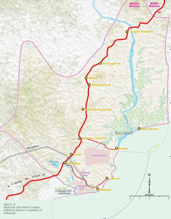
Figure 1: The Coastal Zone of Shama District
Source: CRC Ghana
Aboesi
Aboadzi Ituma
Upper Inchaban
Shama
Anlo beach Yabiw
Apimenim
Komfoeku
Dwomo
Shama Junction
Lower Inchaban
Pra wetland
Anankwar Wetland
Coastal Zone to Accra
to Takoradi
Sekondi Fishing Harbour N1
Shama District KEEA District
Sekondi-Takoradi Metropolitan
Assembly
Pra river
Anankwar lake
Power plant
Pocket beach
Watershed draining into
river Upland Forest
River Delta
Rocky
Shore Rocky Headland
Rocky Shore
Barrier beac h/
spit (backed by lagoon) Estuary
Lagoon (tidal) Akwidaa New
Town
Akwidaa Old Town
FLOODING
FLOODING
FLOODING
Waves that can cause erosion
Net Long shore current and sand
movement Beach, berm,
dunes
River – fresh/salt boundary site
speciic
Wetlands & mangroves SALT BRACKISH
FRESH
Turtle nesting beach
Road to Dixcove
River rises with heavy rain
Coastal features:
• Beaches, Dunes and Barrier Spits, Rocky Bluffs, Rock Outcrops and some Steep Slopes
• River Estuaries, Drainage Outlows, Mangroves, Wetlands Marshlands and Coastal Lagoons
• Flora, tropical foliage forests, fauna, birds, small invertebrates, sea turtles
Dynamics:
Sandy shorelines are highly dynamic features that evolve in response to waves, currents, tides and wind. In many cases sandy beaches are built up by ocean wave energy and backed by wetlands or river
outlows, and are referred to as barrier
beaches. These systems are in constant movement in response to the energy of the surrounding system, and as a result are not advisable building sites.
Figure 2: Detail of coastal zone showing typical features Source: CRC Ghana
Coastal features include beaches,
dunes, rivers, estuaries, salt
marshes, lagoons, wetlands and
mangroves as far as they are
inluenced tidally, so the coastal
zone in some cases, extends
beyond 1km from the outer edge
of these coastal landscapes or
ecosystem features (for detail see
Figure 2).
C.
13
12
1
s
ec
ti
o
n The Coa
st
al Zo
ne and D
e
ve
l
o
pme
nt Co
nte
x
t
The “area of inluence” is the extent of
the area inland in which coastal-related
activities are taking place or could take
place, both emanating from the coast,
going inland, and impacting on the coast
from inland (e.g. large scale infrastructure,
urbanization, industry, pollution of rivers
by mining). In Shama this includes
development pressures arising from
expansion of Sekondi Takoradi Metropolis
eastwards and industrial activities driven
by availability of gas by pipeline from the
oil ields to the District.
1.2 Area of inluence:
socio-economic context
The Western Region Spatial Development Framework, the Coastal Sub-Regional Spatial Development Framework, the Korean International Cooperation Agency Plan and the Spatial
Development Framework for Ahanta West all concur in outlining the likely broad development pattern over the
next twenty years as follows:
• Substantial development of industry, residential and related infrastructure west of Takoradi between the N1 and the coast up to the Butre estuary. • A well serviced and accessed
developing residential, tourism and leisure area between
Dixcove and Butre; a major new
settlement at Agona.
• New roads and services along the N1 and branching to Princes Town and Egyambra.
• The coast and communities
between Dixcove and Princes
Town is likely to remain mostly underserviced and reliant
on eco-tourism, ishing and
agriculture.
D.
Tamale Burkina FAso
T
ogo
Iv
o
r
y C
o
a
st
Accra Takoradi
Kumasi
Figure 3:
Regional and district maps showing factors in sphere of
inluence
Eco Zone
Tourism / Industrial
Zone
Aboesi
Aboadzi Ituma
Inchaban
Shama Assorko Essaman
Ohiamadwen Aboso
Amissakrom
Supom Dunkwa
Anlo Beach Shama Junction
Pra wetland
Anankwar Wetland to Accra
Gas pipeline
to Takoradi
N1
N1
Shama
District DistrictKEEA
Pra river Pra river
Anankwar lake
Industrial area
Industrial area
Industrial area
1
s
ec
ti
o
n The Coa
st
al Zo
ne and D
e
ve
l
o
pme
nt Co
nte
x
Integrated Coastal
Management -
why, what and how?
Section
two:
16
17
2
ec
ti
o
n I
ntegra
te
d coa
st
al m
anageme
nt
2.1 Why?
The coast of Shama District surely represents one of its most distinctive characteristics. The development pressures and the role of this small District as entry point to the Sekondi Takoradi conurbation from Accra which is
expanding into it; the sensitive Pra Estuary;
the presence of the international gas pipeline and power generation project; the need to respect the right of communities, which have lived here for centuries past, to continue to enjoy a prosperous and harmonious life – all
of these conlicting interests require careful
balancing of land uses.
• Land Use pressures: the discovery of oil and gas has created a rush for land by prospective investors and speculators in industrial and other related development as well as pressure on the district’s coastline for development of residential, leisure and hospitality. In the watershed of the Anankwari river for instance, residential units and squatter settlements have more than doubled in the last decade.
• Fisheries decline: declining ish catches,
(the decline in ish catch was mostly
attributed to increased canoe numbers due to increasing population), unsustainable
ishing methods, poor ish quality and
consequently poor life span of processed
ish, conlicts between artisanal and semi-industrial ishers/boats and non-existent/
weak local institutions for managing the
ishery
• Flooding: Risk of people and property to
lood hazards: Infrequent major loods
have caused widespread damage to
property in the watershed and downstream
lood plain of the Anankwar River.
Management of the nearly hundred year old dam located on the upstream of the Anankwar watershed is central to the
looding experienced downstream of the watershed. Also the banks and loodplain of the Pra River are looded during intense
periods of rain, prompting the need to resettle some villages.
• Water supply: Increasing demand on
existing freshwater supply systems: water
supply systems for domestic consumption are increasingly stressed by a rapidly growing population, the construction and operation of large new industrial facilities spurred by the production of oil and gas and the associated hospitality industry. • Coastal Eco-Systems threatened: Coastal
loodplains, wetlands and the district’s
shoreline have been subjected to varying intensities of uses including sand winning and high rate of development which is accelerating
• Other concerns: community perception of inadequate government representation and attention; chieftaincy disputes; poor
R1: Our Coast, Our Future: Western Region of Ghana
This is a major product of the Hen Mpoano initiative. It makes the case that a fresh approach to the governance of the coast and isheries will take root only when it addresses issues that are perceived by the people of the place as important. It covers the major coastal and isheries issues and concludes with a discussion of the actions that Hεn Mpoano proposed to take over a three year period to establish and formalize a governance program for the Western Region that can serve as a model for the nation.
Reference
2.2 The Most Urgent Issues
The coastal zone of Shama District is undergoing rapid transformation due to activities of a fast growing oil and gas
industry. There is a need to conine oil and
gas-related development to certain “hot spots”
(as identiied, for example by the Western
Regional Spatial Development Framework), to maintain sustainable livelihoods, protect the environment and the areas of high landscape value such as the Pra Estuary and Anlo Beach wetland (“green belt areas”) which have
been identiied, while encouraging economic
development.
Critical coastal issues confronting the district
were identiied through technical assessments and participatory land use mapping exercises
involving representatives of diverse stakeholder groups including traditional authorities, men, women and youth. These issues include:
road access/infrastructure; rising social problems; general lack of Primary and Junior High school education, electricity public toilets, health posts and refuse containers.
2.3 What? The Core
Elements of Integrated
Coastal Management
The response to pressures of development
could in fact generate long term beneits
for coastal ecosystems and their dependent communities. With this in mind, the District Assembly has inaugurated an Agriculture and Coastal Management Subcommittee to drive Management Strategy, of which the core elements are:
• Preservation and restoration of important coastal habitat and features that are
critical to sustaining the ishing industry.
• Taking action to control sand winning and destruction of mangroves.
• Creating Land Use and Environmental Policies that balance competing interests of industrial, tourism, food and livelihood security, leisure, commercial and
residential activities while protecting the vital ecological functioning of the land and seascape.
• Supporting traditional and inding new livelihoods for coastal communities
through agriculture, isheries and
aquaculture, as well as providing the access to fully partake in the new forms of development.
• Reducing vulnerability and building adaptive capacity of coastal communities to threats from hazards and climate
change including extreme weather, rising
sea levels and coastal erosion. • Sustained stakeholder enagement
and moves to build co-operation with neighboring districts through a Joint Coastal Development Planning Area; and creating effective links to the regional and national levels of government.
2.4 How? Systems for
implementing Integrated
Coastal Management
Integrated coastal management is a participatory process that engages communities, private sector, traditional authorities and civil society. The mechanisms for implementation at the district level are:
1. The District’s Medium Term Development Plan (MTDP), and Community Action Plans which address settlement growth, economic development and the provision of schools, clinics, other services, roads and infrastructure.
2. The District’s Spatial Development Framework (SDF), Structure Plans (SPs and Local Plans (LPs), which show what can go where, and resolve potentially
conlicting demands on land use in the
coastal zone.
3. Bye laws to deine and protect the coastal zone.
4. Strategic Environmental Assessment which ensure that the necessary environmental protection measures are taken.
The establishment of an Agriculture and Coastal Sub-committee is a great step forward for implementing Integrated Coastal Management. It provides a necessary forum
for integration across sectors such as isheries,
oil and gas related investment activities, land use planningand fresh water supply. The Committee can identify and assess issues, suggest and shape policies, prioritize actions and evaluate outcomes as the Coastal Zone is developed.
At the regional and national scales, many of the objectives of coastal management may only be achieved through joint planning and implementation, involving adjoining coastal districts. For this reason, initiatives such as the Data Hub which has been established at the Western Regional Coordinating Council by Hen
Mpoano for technical support, the ledgling
Joint Development Planning Area for the Coastal Districts of the Western Region, and
Western Corridor Accelerated Development Authority must be supported by all.
This joint approach to planning and decision-making can involve:
• Adoption of region-wide policies for
preventing and mitigating lood hazards.
• Information sharing on techniques for assessing hazards and adaptive capacity of coastal places (eg those used in vulnerability assessment and adaptive
planning exercises at Dixcove and
Akwidaa).
• Collaboration between agencies at regional and national levels on coastal issues. • Effective mechanisms for conlict resolution
and dialogue with parties affected by development decisions.
• Joint initiatives on protection/restoration of critical habitats, forests and wetlands of
regional signiicance by programs such as
Community Resourced Management Areas (CREMAs).
• Decision making on large facility siting and management of alterations of the coastal zone.
All of these will become more evident in coming years if detailed planning and decision-making can be done at community level and linked to regional and sub-regional co-ordination of national and international investments.
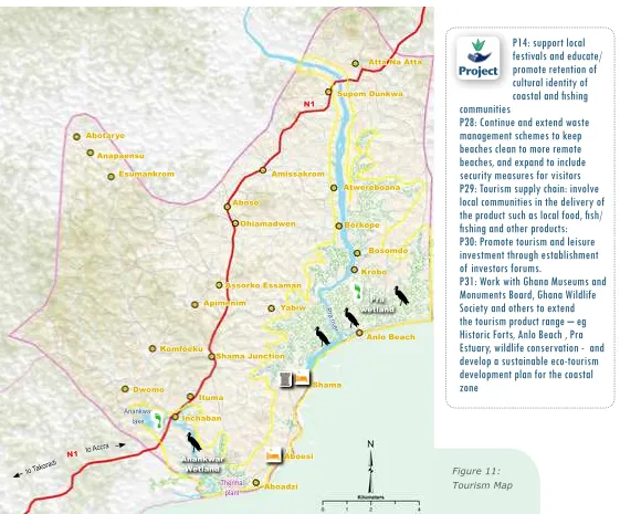
P1: Form Working Groups to deal with speciic
coastal issues.
Project
2.5 Opportunities to
Implement Integrated
Coastal Management
Use of the above planning and decision making processes and environmental assessment provides the foundation for Integrated Coastal Management. District Assemblies suffer from chronic underfunding, but many development partners (governments of United States, Norway, France, Germany, Korea, Belgium, United Kingdom) and private sector such as the Jubilee Partners are funding projects which provide essential parts of the process, including community linkages. These need to be made sustainable in the long term by funding mechanisms such as Assembly’s Internally Generated Funds (eg from property rate, betterment and value capture in new projects), Corporate Responsibility funds of major private investors such as in a Coastal Foundation, and national and international funds for infrastructure and investment.
Section
three:
SHAMA DISTRICT
COASTAL PROFILE AND
DEVELOPMENT ISSUES
20
Shama ICM Toolkit 2013 Shama ICM Toolkit 201321
3
ec
ti
o
n SHA
M
A D
ISTRI
C
T COA
ST
AL PR
O
FILE AND D
E
VEL
O
PMENT ISSUES
3.1 Characteristics of the
Coastal Zone: overview
The Shama District Shoreline is about 13 km stretch from Anlo Beach at the south eastern to the barrier beaches within the vicinity of the
Anankwar loodplain at the south western part of
the District.
The key features associated with the coastal zone are barrier beaches, sand spit and dunes, uplands, estuary, wetlands and rock outcrops. There is also
a major river (Pra river) which lows southwards
and meets the sea at Shama. These features are subject to multiple uses and perform a variety of ecosystem services and functions. Key among the uses of the coastal zone are for residential
and tourism development, recreation, ishing,
industrial and commercial activities.
Anlo Beach and Pra river estuary
This is arguably the most prominent beach and
signiicant coastal ecosystem in the Shama
District. It is more than 170m wide in its mid-section tapering longitudinally eastwards but curving at the Pra estuary. It is evident that the Pra provided an enormous amount of sediment to the long shore drift of material in its formation. The meeting of the muddy waters of the Pra and the long-shore drift of beach material provided the materials that built the bar. The Anlo beach is one of the most beautiful beaches in Ghana in terms of its length and width. It can be developed into a tourism facility using local architecture and involving the local community in its development. Mangroves are common in many places behind the estuaries; it is more widespread and well
developed in the wetlands of the Pra loodplains
behind the Anlo barrier beach.
3.2 Characteristics of Coastal
Zone: off-shore marine areas
and isheries:
The off-shore areas of the coastal zone are
actively used by the artisanal (traditional) ishing leets. Fishing is also the province of larger, Ghana-based semi-industrial ishing vessels and
industrial, intercontinental vessels. There are
locally breeding ish, those inhabiting the Guinean
current across West Africa and those that migrate across larger distances (such as blue whales). Surveys have been carried out to determine the location and type of marine life including juvenile
ish and their breeding, and Marine Protected Areas are being proposed to protect isheries and
improve food security.
Marine areas experience many other uses
such as for a local, national and international highway,
for leisure, cables, pipelines, oil and gas
exploitation. The Marine areas are subject to
increasing kinds of pollution from the wastes of marine and non-marine activities (dumping of waste). As capacity for coastal management increases, spatial planning for the seascape will be necessary to ensure harmony between traditional
uses of the sea for ishing and oil and gas
production activities. Marine Spatial Plans are now being used throughout the world to cope with the increasing pressures.
Sandy beaches Coastal lagoon inlet Rocky shore
Figure 4: Shama District shoreline Source: CRC Ghana Pra Wetland
Aboesi
Aboadzi
Shama
Anlo Beach
Industrial area
3
s
ec
ti
o
n SHA
M
A D
ISTRI
C
T COA
ST
AL PR
O
FILE AND D
E
VEL
O
PMENT ISSUES
P2: Prepare Marine Spatial Plan
R3: Nearshore Rocky Reefs of
Western Ghana, West Africa:
Baseline ecological research surveys.
Ateweberhan,M.,Gough,C., Fennelly L.
and Frejaville, Y. 1.
Project
Reference
Ecological information on the near shore rocky reef habitats (NSRH) of Ghana is very limited. The present study ills this knowledge gap, by investigating the general status of the NSRH and isheries of western Ghana, and providing baseline information on the ish, invertebrate and benthic communities.
R4: Assessment of Fishing Grounds in the Nzema East and
the Ahanta West Districts
A rapid appraisal conducted in nine (9) main landing sites in the Nzema East and Ahanta West districts between 14th and 21st September 2010. The communities visited were, Ankobra (Sanwoma), Apewosika (suburb of Axim), Miamia, Princes Akatakyi, Cape Three Points, Akwidaa, Dixcove, Busua and Butre. The purpose of this assessment was to ascertain primary information of the spawning and ishing grounds among others. The research team was made up of two persons; a staff of the Western Regional branch of the Ghana Canoe Fishermen Association and a staff of the Friends of the Nation. Data was collected through focus group discussions, participatory mapping, direct observations and key informants interviews.
R5: Determining The Origin And Ecology Of A Macroalgae
(Ulva clathrata) Bloom Along The Coast Of Western Ghana
And Cote d’Ivoire.
3.3 Characteristics
of the Coastal Zone:
areas of restoration
and preservation
Sites which are a priority for preservation are the Anlo beach wetlands and associated estuary and mangrove ecosystems, Anankwar wetlands, key river and lagoonal estuaries and scenic and historic
sites. Some are already oficially
recognized and those that are of
more local signiicance should also be
differentiated.
Ultimately this could include the marine part of the coastal zone with protected areas such as Marine Conservation Areas and Sanctuaries, Fishery Conservation and Closure Areas, and Essential Fish Habitats.
P4: Undertake public
education on the beneits
of conservation of coastal
ecosystems.
P5: Work with Marine
Protected Areas Inter
ministerial Committee over
designation of marine
protected areas.
Project
R6: Report on Characterization of coastal
communities and shoreline environments in the
Western Region of Ghana.
This report provides information on the conditions and environmental, social and economic issues faced by 89 coastal communities in the six coastal districts of Ghana’s Western Region. Rapid appraisals of coastal communities, district level validation workshops and secondary literature review were undertaken to provide additional information that will ultimately contribute to assembling the baseline. While rapid appraisals gleaned community scale information, it also provided the opportunity to socialize the initiative among coastal communities visited. The purpose of district scale workshops was to solicit inputs from local people as well as reactions to indings of the rapid appraisals and to incorporate local perceptions of changes into a district level synthesis of coastal and isheries governance issues.
Reference
of rocky shore and headlands which form the
partially protected ishing areas of Aboadze,
Aboesi, Shama town and Anlo. Water dependent
uses such as ish landing and mooring areas, pipelines (for example at the VRA Thermal
plant) and marine transportation terminals need to be located in these dynamic areas, along with a minimum number of facilities necessary to support public access to the shore and recreational use. Fish handling and processing are also found near the shore for reasons of operational convenience, as are military
fortiications, light houses and other aids to
navigation. Most other uses do not need to be
near the shore, especially open coasts exposed to
high energy waves, strong currents and periodic storms. However, dense settlements have
emerged around the ishing ports, well-to-do
property owners are seeking waterfront property and views and investors are seeking coastal locations for resorts and hotels, all placing their investments in the way of natural shore building and erosion processes. The measures used to protect structures placed too close to the sea usually accelerate the erosion and shore change process further.
As a result, coastal erosion is destroying
habitats and property including artisanal ishing settlements, ish landing sites and beaches in
Shama. Though it slightly varies from one coastal community to the other, overall the Shama
Aboesi Figure 5: Sensitive
areas in need of protection in Shama District.
Wetlands
Anankwar lake
3.4 Relief, Drainage and Climate:
Coastal Dynamics, Human Uses
and Implications
3.4.1 Shoreline Beaches, Dunes and
Barrier Spits: human and natural hazards
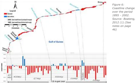
Due to rising sea level in recent decades, most barrier beaches in Ghana are retreating at a rate of about 1m per year and in the Western region, are estimated to be retreating at 2m per year on the average. Erosion, sea level rise, and sand winning from the beach can all result in land loss and the inland movement of the shoreline.
Eroding coastline Most of Shama’s shoreline consists of sloping sandy beaches backed by barrier spits, dunes, low and high bluffs, interrupted by sections
District shoreline has eroded by approximately
100 meters in the last 5 decades. Clearly, a combination of high wave energy and human activities, notably the practice of sand winning, is resulting in coastal erosion. Though sand winning is illegal under the bye-laws of the district
assembly, it is being practiced intensely along the beach front of some coastal communities. Other key assets and energy infrastructure are also threatened by this activity. Most sand miners who are desperate to make their living vent their spleen on the volumes of sand at the beaches in the district. However, ways to address coastal erosion is a great challenge for many coastal communities.
In Anlo Beach, for example, the whole settlement
has been under threat from coastal erosion and sea level rise for many years. Twice a year the
community is looded for several weeks by sea
water destroying properties and obstructing economic activities. Similar incidence of coastal
looding has been noted in all the coastal
communities with varying impacts based on the elevations above sea level.
Atempts are being made to control shoreline erosion in some areas using gabions and boulders. In other areas, refuse is dumped at the shoreline to delay the rate of erosion. The current trends indicate that these measures have not been adequate in addressing the issue
Figure 6:
Coastline change over the period 1895 - 2002. Source: Boateng, 2012 (1) (See notes on page 46)
24
Shama ICM Toolkit 2013 Shama ICM Toolkit 201325
of shoreline erosion. At the same time there is a disconnect between the Hydrological Services Department, projects conceived at the national level, and the district and community level which needs to be radically re-thought.
Several methods are being used by the Hydrological Services Department of the Ministry of Water Resources, Works and Housing to control shoreline erosion including the use of gabions and boulders and other engineering solutions. However, high energy waves, strong currents and periodic
storms expose the weakness of these defense
mechanisms. In many cases relocation is the only
real alternative, but accepting this is dificult, and
therefore attempts to reserve lands for relocation of settlements are inadequate.
From a hydrologic perspective, wetlands serve to dampen the effects of changing water levels,
thereby providing protection from looding. In the process of slowing loodwaters, wetlands trap and
store sediments, limiting erosion and in some cases actually building up soil. Through this process, they
protect coastal waters from excessive runoff and
sedimentation. Coastal communities often rely on these areas for their drinking supply, so maintaining
the low levels and cleanliness of the water is vital
to community health.
In recent times however, coastal loodplains and
wetlands in the district have been subjected to varying intensities of uses and high rate of development, due in large part, to a rapidly growing population of the district and associated pressure on land resources. In the watershed of the Anankwari river for instance, residential units and squatter settlements has more than doubled in the last decade. Management of the nearly 100 year old dam located on the upstream of the watershed is
central to the looding experienced in the loodplains
located downstream of the watershed.
Infrequent major loods have caused widespread
damage and loss of life in the watershed and
downstream lood plain of the Anankwari River. In recent years, the banks and loodplain of the Pra river are looded due to intense periods of rain,
prompting the need to resettle some villages. The mouth of the Pra river consists of a barrier spit and dynamic nearshore environment that is generally accumulating beach area due to the fact that the Pra is a major source of sand to the beaches of the region. However, other parts of the shore, including
the length of Shama town, are experiencing high
rates of erosion prompting the installation of hardened shoreline, mainly riprap. The gas pipeline
landing at the VRA Thermal Plant also has extensive
riprap. Gabions (rocks enclosed in wire baskets) are found in several locations, the idea being to create groins that trap sand moving along the shoreline. However, all of the gabion installations are broken and not serving their intended function.
Changes to coastal loodplains and wetlands are
evident in the creation of impervious surfaces caused primarily by the construction of roads in low lying areas. Over the years, this has reduced the amount of vegetative cover required to intercept storm water run-off. In low lying areas where mangrove wetlands are part of the ecosystem, mangroves are harvested without re-planting or
P6: Increase collaboration with the Ministry
of Water Resources, Works and Housing for
regulating private development and installing
publicly funded defenses.
P7: Where acceptance of land loss is agreed as
the best option long term, plan re-settlement
schemes and incorporate as objective in
Structure Plans.
P8: Develop a public education programme on
coastal hazards and climate change
P9: End destructive sand winning practices by
use of bye laws and community sensitisation
P10: Prepare coherent shoreline management
plans to regulate coastal land use.
Project
Good Management Practices
Support Urbanization, Sanitation and Wastewater
Management in the Coastal Zone:
Dixcove Case Study
Case
study
3.4.2 River Estuaries,
Drainage Outlows, Mangroves,
Wetlands, Marshlands and
Coastal Lagoons
Wetlands and coastal water resources serve vital functions in the environment. They provide habitat for many plants and animals, including migratory
birds and many types of ish. Mangrove areas, in
particular, are important to the overall health of
the marine isheries, because they provide habitats for shellish as well as nursery grounds to juvenile ish. Mangrove wood is harvested for a variety of
purposes, but this practice should be limited due to the damage to wetlands that overharvesting causes.
3
s
ec
ti
o
n SHA
M
A D
ISTRI
C
T COA
ST
AL PR
O
FILE AND D
E
VEL
O
High risk In most cases, removal of mangrove stands paved
the way for dumping of garbage in the wetland areas. This practice does not only reduce water retention capacity of these systems, but also
reduce the abundance of the ishery in these areas
by diminishing the nursery grounds, which is a key function of mangroves and their associated estuaries. Another common problem in the district
is the continuous illing of coastal loodplains and
wetlands for constructing residential, industrial and commercial facilities. This practice has degraded
several loodplains and wetlands and disrupted the associated lood control functions performed by
these ecological systems.
As a result, looding episodes (2) have caused
varying degrees of destruction to infrastructure and property in the district. For instance, the
looding of July, 2009 resulted in the destruction
of 60 and 78 houses in Krobo and Anlo Beach
respectively; the most recent looding in July 2011 on the Anankwari loodplain displaced 625 people
at Inchaban; this was in addition to hundreds of people displaced and thousands of cedis worth of crops and livestock destroyed through the process. Other communities such as Adjokrom, Bosomdo, Supomu Dunkwa, Abuesi, Aboadze, Fawomanye and Shama Town, witnessed many more losses of property and livelihoods.
P11: Establish new and support existing
Community Resource Management Areas
(CREMAs) to protect and enhance wetlands
P12: Designate both on shore, including
wetlands and mangroves, and maritime
preservation areas in Structure Plans and
Local Plans
P13: Incorporate policies in plans and bye
laws to reduce impact of dams, creation of
impervious surfaces in development and
blockage of water courses
P32: Undertake public education on values
and importance of wetland ecosystems
Project
R9: Carbon Stocks And Soil Nutrient Dynamics In The
Swamp Forests Of The Amanzule Wetlands & Ankobra River Basin
The swamp forests of the Amanzule Wetlands and Ankobra River basin is a truly unique landscape. Threats to the swamp forest, while still minimal, may bemounting, particularly in the form of small-scale artisanal logging, irewood harvesting, and conversion to food crops like maize and cassava farming. As demonstrated by this study, these anthropogenic activities have a detrimental impact on the ecosystem’s ability to store and sequester carbon, as well as on biodiversity and nutrient dynamics. Therefore, conservation of this intriguing and rare landscape is crucial. While more research is required, it is possible that carbon inance, in the form of REDD+, soil carbon, or climate smart agriculture could form part of a dynamic conservation and livelihood strategy.
R10: Mapping and Modelling Mangrove and Swamp Forests
Dynamics in the Great Amanzule Wetlands, Ghana
Ghana’s mangroves continue to reduce in health and coverage, especially in areas outside the ive Ramsar designated sites in the country. Moreover, the use of compensatory mechanisms in addressing the exploitation of coastal ecosystems and climate change mitigation is in its nascent stages in Ghana because of the uncertainties in their carbon stock estimates due to uncertainties in their real extent. The main objective of this study was to apply remote sensing technology to map the past and present areal extent of mangroves in the Ellembelle district in the western region of Ghana, especially in the face of limited data. Three main remotely sensed data were used in the study: a true color orthorectiied digital aerial photo (AP); and two satellite data sources - RapidEye and Landsat Thematic Mapper (TM) imagery. Additional data were acquired through a participatory mapping exercise and a GPS survey. Other ancillary data like an existing land use/ land cover map of the area was used for the mapping.
R11: Biodiversity Threats Assessment for the Western Region of
Ghana.
This review of biodiversity threats in the coastal zone of the Western Region of Ghana covers both terrestrial and marine systems and includes maps and descriptions of important wetlands and habitats.
R12: Rapid Biodiversity Assessment on the Essei and Butuah
Lagoons and the Whin River Estuary in the Sekondi-Takoradi
metropolis of the Western Region of Ghana
This rapid Biodiversity Assessment on the Essei and Butuah Lagoons and the Whin River Estuary in the Sekondi-Takoradi metropolis of the Western Region of Ghana concludes that deplorable management, ignorance or conlict of interest on the part of users has led the wetlands onto a path of potentially irreversible destruction. A new type of coastal management thinking and practice are needed that takes into account Ghanaian economic, socio-cultural and environmental perspectives.
R13: Approved byelaws for wetland conservation in 4 areas
(Butre, Busua, Akwidaa, and Princes Town)
Cape Three Points – Princes Town CREMA Constitution and Resource Management Bye-law was amended to include provisions that call for the development of management plans for CREMA wetlands. The revised bye-law was approved by the Assembly.
R14: Model Bye-laws for Coastal Management in Ghana:
Experiences from Shama District
Through Hen Mpoano-facilitated technical assessments, stakeholder engagements and participatory mapping exercises, model bye-laws and policy statements for lood hazard mitigation, shoreline and wetland management were formulated and approved by the district assembly.
R15: Report on Land use mapping, shoreline classiication
and vulnerability assessment in the coastal zone of Shama
District.
General reference maps showing annotated settlements, water bodies and areas liable to looding were composed for the six coastal districts. Additionally, large format thematic maps of Hen Mpoano’s focal areas, namely: Anlo Beach–Shama District, Anankwari Catchment Area–Shama District, Cape Three Points – Ahanta West District and the Greater Amansuri Area – Ellembelle and Jomoro Districts were generated.
Shoreline features were also identiied and classiied and their signiicance determined. This provided preliminary information to guide local level management of the shoreline.
Vulnerability assessment was conducted for Shama and Inchaban, where people, natural environment and property are at risk from looding.
R7: Rapid assessment of mangrove status and
conditions for use to assess potential for marine
payment for ecosystem services in Amanzule and
surrounding areas in the western coastal region of
Ghana, West Africa
Ghana’s mangrove ecosystems are tremendously valuable, providing ecosystem services like carbon sequestration, protection from storms, loods, and erosion, provision of timber and non-timber forest products, processing of waste and nutrient pollution, aquaculture and agriculture support, and habitat for aquatic and terrestrial species. Yet, as in many other parts of the world, short-term development needs are undermining long-term mangrove health and survival. Fortunately, economic mechanisms have the potential to tip the balance toward restoration, maintenance, and protection of mangrove forests. The need for proper valuation of mangrove ecosystem services underpins such mechanisms towards the establishment of any realistic payment for ecosystem services scheme in any given mangrove or wetland habitat.
R8: Coastal Hazards and Flooding Risk in Ghana’s Western Region
This issue brief highlights the key issues facing Ghana’s Western Region in terms of coastal looding in low-lying areas as well as shoreline erosion, and recommends policy options to improve public safety and reduce environmental impacts.
28
Shama ICM Toolkit 2013 Shama ICM Toolkit 201329
High 254 m
3.5 Vegetation, Flora, Tropical
Foliage Forests, Wildlife
3.5.1 Coastal Vegetation, farming,
forest reserves.
The Digital Terrain Map (Figure 8 below) shows how little of the coastal zone is neither covered by wetlands nor settlements. The original forested vegetation in the district has been reduced to coastal shrubs. However, there are patches of secondary thick bushes and other small size trees in the northern parts of the district. This kind of vegetation supports oil palm and maize which are done on limited bases in the district. This reduction in forested cover is attributable to poor farming
practices, bush ires and sand winning activities. Coastal communities combine farming and ishing for their livelihoods, with a mixture of cash and
subsistence food crops. Subsistence food crop
areas suffer from over exploitation and subdivision
among increasing number of family members.
The participatory mapping exercises which Hen
Mpaono carried out for the whole of Shama District led to policies in the Spatial Development
Framework which identiied conservation areas and
inland “green belt” which should be reserved for
subsistence agriculture and cash crops, i.e. use by traditional farmers.
The balance between income from cash crops and land available for food, is a key factor in sustaining livelihoods and food security. The mapping of rural land uses and slope analysis will enable decisions
to be made about the most eficient balance of
uses. This designation of land for agriculture, added to protected areas/corridors for wildlife will enable the best decisions to be taken about areas for urbanisation, tourism, leisure and industrial development.
In this context, it has been proposed (3) that,
considering that even large areas of green resources may be permanently destroyed through unplanned development, the concept of a “Green Network” such as has been adopted by Ahanta West, based on the Korean International Cooperation Agency Plan, will be a useful development planning tool for the District.
3.6 Settlements, Spatial
Analysis, Siting of
Infrastructure
3.6.1 Growth of the Coastal and
Fishing Settlements
According to the 2000 Population and Housing Census (PHC 2000), the population of Shama district was nearly 70,000 and this increased to nearly 90,000 by 2008. The growth rate in the district was higher than the regional and national averages. Reasons for the increase in population (4) were high in-migration of
isher-folks from central region, uncontrolled
births and teenage pregnancy especially in
the ishing communities resulting in high
school drop-out rate. Since the last 3 decades the district has witnessed an increase in the number of basic and secondary schools. However, performance at the basic education level has consistently fallen in the past decade. Fertility in the district is quite high with 2,115 pregnancies in 2008 increasing to 2,491 in 2009.
Areas with high population density include
Shama, Aboadze and Abuesi which are ishing
communities. Other highly populated areas are Inchaban and Supomu and Dunkwa.
The natural growth of populations in existing
impoverished coastal communities, which is substantial, will be met by in-migration of those more wealthy individuals who are seeing the potential of the coast for residential, leisure and new industrial development.
3.6.2 Cultural context and traditions in
Coastal Communities
The Shama traditional area is headed by a Paramount Chief with jurisdiction over three main Chieftain Divisions and several sub chiefs. The three Chieftain Divisions are Inchaban, Yabiw and Dunkwa. All traditional stool lands are vested in the paramount Chief of the traditional area.
Fante is the dominant ethnic group in Shama, constituting 86.49% of the total population while settlers account for 13.51%. The Fantes mainly reside westwards of the Pra River. Two main groups of Fantes can be distinguished;
the irst are the indigenes of Shama who
identify themselves as Fantes with Techiman as their ancestral origin while the second are migrant Fantes from Moree, Apam and Winneba in the Central Region who acquired permanent residency in Shama over 5 decades ago. While the indigenes reside at Shama Bentsir and Shama Apo, the migrants are
conined to Amena-ano. There is a fair level
of interaction between these two groups. Residing at Anlo Beach, on the farthest South-east, are the Ewes who are the ethnic minority in terms of population size. Canoe or boat transport is by far the major means of transportation from Shama to Anlo Beach.
Artisanal ishing communities represent a
unique and distinct culture which arises from the activity. Fishermen are at sea in canoes for three to four days at a stretch, while others are mending and making boats, nets and
ishing gear. Women prepare, smoke and sell the ish.
Fishing migration is a common practice in Shama to other coastal areas in Ghana or coastal countries in the sub-region in response
to availability of ish or the need to raise
R16: Land Cover Mapping of the
Greater Cape Three Points Area Using
Landsat Remote Sensing Data Map
Book
This is the companion book of maps for the land cover study. The land use and land cover map products created in this study are the irst available data for the coastal region of Ghana. The maps represent an important step in the management of its natural resources. Land use and land cover maps allow land managers, policy and decision makers, and local communities to make informed decisions about the future of their natural, cultural and economic resources. This set of maps can also provide a window into how the landscape has changed as the baseline data for possible future work. With the baseline data ready, the next step of change analysis will be possible. The choice to use the U.N. Land Cover Classiication System also provided the lexibility to meet classiication needs in the future while still maintaining continuity with past work.
R17: Report from Community Conservation on
Primates in the Western Region.
Field notes from Horwich’s site visit and recommendations for improved management of the forest reserves and alternative livelihoods for the adjacent communities. Horwich made two additional visits in 2012 which are also included in this report. Figure 8: Digital Terrain Map of Shama District.