Marine Biodiversity Assets and Threats Assessment
Photo Credit : WWF- WAMER
Gambia-Senegal Sustainable Fisheries Project September 2009
A partnership of:
United States Agency for International Development / West Africa Coastal Resources Center, University of Rhode Island
World Wide Fund, West Africa Regional Office Department of Fisheries,
Ministry of Fisheries, Water Resources and National Assembly Matters, The Gambia
This publication is available electronically on the Coastal Resources Center’s website at http://www.crc.uri.edu. For more information contact: Coastal Resources Center, University of Rhode Island, Narragansett Bay Campus, South Ferry Road, Narragansett, Rhode Island 02882, USA. Tel: 401) 874-6224; Fax: 401) 789-4670; Email: [email protected]
Citation: Virginia Lee, James Tobey, Kathy Castro, Brian Crawford, Mat Dia Ibrahima, Ousman Drammeh, Tanvi Vaidyanathan, 2009, Marine Biodiversity Assets and Threats Assessment, Gambia-Senegal Sustainable Fisheries Project, Coastal Resources Center, University of Rhode Island. pp 50
Table of Contents
BACKGROUND ... 1
THE MARINE BIODIVERSITY ASSETS OF THE WAMER ... 3
Introduction to the West African Marine Eco Region ... 3
Marine Biodiversity Assets in the WAMER ... 4
Direct Threats to Marine Biodiversity Conservation in the WAMER ... 6
Indirect Threats to Marine Biodiversity Consrevaton in the WAMER ... 9
Current Prioirties & Actions for Marine Biodiversity Conservation... 10
Recommendations for Marine Biodiversity Conservation in the WAMER ... 13
THE GAMBIA... 16
Introduction to Marine Biodiversity in the Gambia... 16
Marine Biodiversity Assets of the Gambia... 19
Direct Threats to Marine Biodiversity in the Gambia ... 28
Indirect Threats to Marine Biodiversity in the Gambia ... 31
Official Priorities for Conservation of Marine Biodiversity in the Gambia ... 33
Current Actions/ Governance/ Legislation ... 35
RECOMMENDATIONS... 43
Foster a more sustainable marine fishery... 43
CONCLUSIONS... 44
Abbreviations and Acronyms
ADB African Development Bank
AFDP Artisanal Fisheries Development Project
BADEA Arab Bank for Economic Development
CCLME Canary Current Large Marine Ecosystem
CFC Community Fisheries Center
CMC Central Management Committee
DOF Department of Fisheries
FAO United Nations Food and Agriculture Organization
LME Large Marine Ecosystem
NAAFO National Association of Artisanal Fisheries Operators
GAMFIDA Gambia Fisheries Development Association
NEA National Environment Agency
DoF Department of Fisheries
SUME Sahelian Upwelling Marine Ecoregion
WAMER West African Marine Ecoregion
BACKGROUND
The Ba Nafaa Project is a five-year regional initiative supported by the American people though the U.S. Agency for International Development (USAID)/West Africa Regional Mission. It is implemented through the University of Rhode Island (URI)-USAID cooperative agreement on Sustainable Coastal Communities and Ecosystems (SUCCESS). The World Wide Fund West Africa Marine EcoRegional (WAMER) Program is the regional implementing partner. Project activities are carried out in partnership with the Department of Fisheries (DoFish) and stakeholders in the fisheries sector in The Gambia and in Senegal. Most of the project activities focus on The Gambia.
Senegal and The Gambia are located within one of the most diverse and economically important fishing zones in the world - the WAMER. Over 1,000 species of fish have been identified, along with several species of cetaceans including dolphins and whales, and five species of endangered marine turtles. The coastal wetlands are globally significant breeding and over-wintering grounds for numerous migratory birds. However, this extraordinary biodiversity is threatened by overfishing. In partnership with the
Government of The Gambia and WWF, this Ba Nafaa project aims to formulate, adopt and implement strategies to overcome unsustainable and destructive marine resource use practices that threaten biodiversity conservation in the Ecoregion.
USAID funds for this program are part of the U.S Congressional Earmark for biodiversity conservation within USAID. As such, it has certain requirements it must meet by law. The Agency's "biodiversity code" guides the Agency in determining what programs are included in the accounting toward the biodiversity earmark. Within the code are four criteria:
1. The program must have an explicit biodiversity objective, it is not enough to have biodiversity conservation result as a positive externality from another program; 2. Activities must be identified based on an analysis of threats to biodiversity; 3. The program must monitor associated indicators for biodiversity conservation; 4. Site-based programs must positively impact biologically significant areas.
This Biodiversity Assets and Threats Assessment of marine fishery related resources of The Gambia and Senegal is based on a desktop review of many reports and documents and a two-week visit to The Gambia and Senegal in June 2009. The fact finding trip included expert consultations; interviews with government officials, fishermen and women, and the private sector fishing industry; a two-day stakeholder workshop, and a meeting with The Gambia National Fisheries Advisory Committee. A list of individuals consulted is included in Appendix 1 of this report.
Objectives for the Ba Nafaa Project are based on this Marine Biodiversity Assets and Threats Assessment. Accordingly, key Ba Nafaa results are to:
• Build institutional capacity at all levels of governance to implement a fisheries co-management approach is strengthened in order to sustain socio-economic benefits for fisher folk and other beneficiaries in the market value chain.
• Reduce unsustainable and destructive marine resource use practices, including by-catch of marine turtles and juvenile fishes.
• Protect key habitats and marine areas important in the life stages of commercially important fish as well as threatened and protected species of marine turtles and mammals.
Within The Gambia, specific objectives are to:
Project Strategies • A participatory co-management
approach that engages fisherfolk in decision-making.
• An ecosystem-based approach that looks not only at the fish, but protection of critical habitats and reduction of fishery impacts on threatened marine species
• Mainstreaming gender dimensions that provide opportunities for both men and women to benefit economically and participate in decision-making.
• A threats-based approach to coastal and marine biodiversity conservation.
• Strengthen the capacity of community fisheries centers to manage fisheries and engage in more effective enforcement of rules through training and learning-by-doing.
• Strengthen the capacity of the DoFish and community management committees to conduct fisheries stock assessments and implement community-based management plans.
• Identify and then implement opportunities for improvements in the value chain of the key species of economic importance, including export opportunities that provide socio-economic benefits to Gambians.
• Establish community-based protected areas to serve as critical habitats for marine turtles and mammals and as spawning and nursery grounds for commercially important fish.
Regionally, the Ba Nafaa Project aims to:
• Strengthen regional management of shared stocks by addressing licensing and registration issues for domestic and foreign fishermen.
• Improve international trade competitiveness through harmonized policies. • Increase regional cooperation for conservation of marine turtles and mammals. • Promote bilateral exchanges of communities and government officials to share
THE MARINE BIODIVERSITY ASSETS OF THE WEST AFRICAN MARINE ECO-REGION
Introduction to the West African Marine Eco Region
Senegal and The Gambia are centrally located within the West African Marine Eco-region (WAMER) that spans 3,500km of the coasts of Mauritania, Senegal, The Gambia, Cape Verde, Guinea Bissau, and Guinea ( Figure 1 and Table 1).
Fig. 1: Map of the West African Marine Eco Region (WAMER)
Source: WWF-WAMER, 2003
At the southern edge of the Sahara desert, the region is the northern limit of distribution for a large number of coastal and marine animals and plants. Coastal habitats in the region are diverse; they vary from the desert sandy shores of Mauritania in the north, through deeply indented, estuarine and island coasts (e.g. Guinea-Bissau and the Gambia), to the lagoonal coasts with their extensive barrier beaches on the Gulf of Guinea (UNEP, 2007). The Senegal, Volta and Niger rivers are dammed variously for agricultural irrigation and hydropower, altering the nature of water and sediment discharge to the coast (UNEP, 2007). The Gambia River, however, is not yet dammed and is lined with extensive mangrove forests along the tidal stretches.
Table 1: Characteristics of the WAMER countries
Mauritiana Senegal The Gambia
(km2) 1,030,700 196,190 36,120 289,587 289,587 4,033
Exclusive
184,600,000 457,120,000 4,400,000 51,400,000 98,456,000 9,885,000
Source: Earthtrends (WRI), CIA Factbook
Marine Biodiversity Assets in the WAMER
The WAMER is one of the world's most biologically outstanding marine habitats, ranking among World Wide Fund for Nature's Global 200 eco-regions, (WWF, 2009 a). Four species of endangered marine turtles: green turtles, hawksbill turtles, loggerhead turtles, leatherback turtles, nest in this region. Additionally, the region is the most important breeding site in the world for the highly endangered monk seal. The region hosts 20 species of endangered cetaceans (including the Humpback Whales) and the severely threatened West African Manatee It is classified as a rare species. The sawfish- an emblematic fish of the eco region- is endangered (WWF WAMER, 2003). Areas of international, regional and local significance within the WAMER are shown in Figure 2. The stretch from the Saloum Delta in Senegal, The Gambia River and the entire coastline of the Gambia, as well as the Casamance river system is one contiguous area that has regional biodiversity significance.
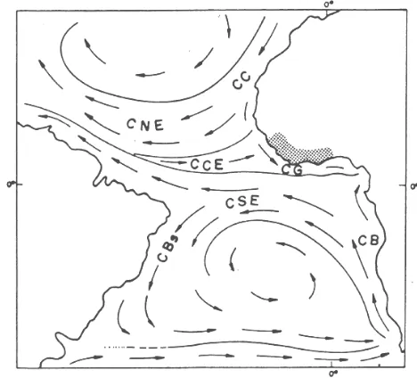
its nutrient-rich coastal upwellings. Countries from Guinea-Bissau to Nigeria flank the Guinea Current LME which is sustained by the eastward-flowing warm Guinea Current (Fig.3). These powerful oceanic currents create a tremendously productive food chain that supports one of the most diverse and economically important fishing zones in the world. Over 1,000 species of fish have been identified, along with several species of cetaceans including dolphins and whales, and five species of endangered marine turtles. This immense productivity is further enhanced by several major river/estuary/delta complexes that provide additional influx of nutrients and sediments to the marine realm, adding to its biological productivity.
Fig. 3: The Canary Current, The Equatorial Counter Current and the Guinean Current
Source: http://www.fao.org/docrep/003/u1509e/U150902.gif
Fish that spawn in northern nurseries seasonally migrate southwards (as do the
fishermen) and provide food for human fishing communities along the way. In addition, recent satellite tracking has confirmed that green turtles lay eggs along the remote
beaches of Guinea Bissau and travel northwards through Senegalese and Gambian waters to graze in the rich sea grasses of Mauritania. In short, the unique combination of climate and upwelling supports species and habitats that represent critical resources locally, nationally, regionally, and globally.
provide food for human fishing communities along the way (WWF, 2009). Marine fisheries make an important contribution to food security, employment and national income to each of the countries in the region. However, a look at the current fishery stock shows alarming decreases in average size of fish caught, as well as reductions in Catch per Unit of Effort (CPUE) for various species.
Marine Mammals: The region is home to several species of cetaceans including dolphins such as the bottlenose and humpback dolphins, and whales, the West African manatee and a colony of 100 monk seals—the largest breeding colony on earth (UNEP, 2007). In Mauritania, an estimated 23 per cent of the mammals are now at risk (WCMC 1992).
Turtles: The region is home to four species of marine turtles1) green turtles (Chelonia mydas) 2) hawksbill turtles (Eretmochelys imbricata;) 3) loggerhead turtles (Caretta caretta) 4) leatherback turtles (Dermochelys coriacea). All are classified as either endangered or critically endangered on the IUCN red list.
Birds/ Waterfowl: The wetlands and estuaries are globally significant breeding and over-wintering grounds for numerous migratory birds, including palaearctic migrants along their migration route between Southern Africa and Northern Europe. These include: waders, terns, herons, osprey, and other birds of prey. The WAMER is a significant part of the East Atlanic Flyway (WWF-WAMER,).
Invertebrates: Little is known about invertebrates in the WAMER. The most important commercially fished species are cephalopods and shrimp (UNEP, 2007).
Seagrass: Recent satellite tracking has confirmed that green turtles that lay eggs along the remote beaches of Guinea Bissau travel northwards through Senegalese and Gambian waters to graze in the rich sea grasses of Mauritania (WWF-WAMER, 2003).
Mangroves and Wetlands: Mangroves are abundant in the Niger Delta covering many thousand square kilometers, and also in Guinea-Bissau (2,366 km2), Guinea ( 2,039 km2), Senegal (1,690 km2) and The Gambia (UNEP-WCMC,2000). The delta wetlands of the Senegal, The Gambia and the Geba-Corubal rivers are prominent feeding grounds for migrant birds on the East Atlantic Flyway (FEOW, 2009).
Reefs: Coral reefs occur only in the Cape Verde Islands. Recently published studies have identified Cape Verde as both a centre of endemism, because of its unique and rare species, and as a top 10 global hot spot for coral communities (UNEP, 2007).
Direct Threats to Marine Biodiversity Conservation in the WAMER
social development.. The fishery sector is a source of foreign currency, jobs and food for more than 22 million people in the region (WWF-WARPO, 2003).
The industrial fishing effort both from West African national and from distant foreign fleets is a major threat. European fleets are highly subsidized and are guaranteed access to the waters of this region through agreements conducted with the European Union. All the countries in the eco-region, except The Gambia, have fisheries agreements with the European Union (EU). For instance, Mauratania, has agreed to allow 200 boats flying the flags of some 13 EU nations to catch many species of fish in Mauritanian waters. The EU pays Mauritania 86 million euros ($125.8 million US) a year, which represents almost a third of Mauritania's national revenue1. The impact of Asian fleets from China, Taiwan, Korea, Japan are not reported, but are estimated by fishery experts to be highly
significant. Other important pressures are coming from former Soviet countries. Despite increasing catches by foreign fishing fleets, the economic growth and social benefits from marine resources have not been realized in many Western African countries where these fleets fish (UNEP, 2007).
Competition between foreign vessels and artisanal fishing boats cause problems of safety at sea. Stock scarcity and technological development have persuaded artisanal fishermen to go far offshore and fish in the same areas as the foreign vessels. Some of these foreign vessels (and national industrial fishing vessels) illegally fish in the coastal areas reserved for artisanal fishing (up to 6 miles offshore). This leads to collisions between these vessels and the pirogues, which cause serious material damage and even loss of life (WWF-WARPO, 2003). The intrusion of trawlers in the six mile zone also contributes to destruction of benthic habitats on the seabed.
Over the past three decades, artisanal fisheries in West Africa have expanded
tremendously. Landings by artisanal fisheries in Senegal, for example, have increased 6-fold in the last 30 years. Now, 80% of the Senegal’s catch, some 400,000 tonnes per year, is landed by artisanal fishers (WWF-WAMER, 2003). This development has been
encouraged by many factors, such as state subsidises, priority access to most of the coastal fishing areas, technological development including motorization of the pirogues (the local wooden fishing boats), and increased access to the more lucrative European, Asian and American markets..
Significant changes in species composition and fishery patterns have occurred, due to overfishing, as shown by a decline in CPUE and the taking of immature fish by artisanal fishers (NOAA, 2003). As more boats search for fewer and fewer fish, there is a dramatic increase in the use of destructive, habitat-destroying fishing techniques such as dynamite fishing, bottom trawling, fine meshed beach seining and turning seines (WWF-WAMER, 2003). Traditional methods of local management have largely broken down and present management regimes cannot cope with the new situation. Moreover, most of the
countries in the ecoregion have no long-term policies with a clear vision of priority actions to be taken in order to maintain the productivity of marine and coastal resources (WWF-WAMER, 2003).
2. Bycatch of endangered species: Increased fishing has also led to increased capture of endangered marine turtles, juvenile fish, and a massive expansion of the trade in shark and ray fins. Threats to marine turtles include harvesting and overexploitation of eggs, meat, and other products; as by-catch in gill nets and trawlers; and habitat degradation and destruction seriously depleted in others (WWF-WAMER, 2003). Conservation actions are impeded by the lack of/incomplete information regarding turtle habitats and their population dynamics. The capture of sharks and rays, considered as ‘keystone species’, is considered particularly destructive because of their presence at the top of the marine food chain thereby stabilizing whole marine communities. They reproduce very slowly and have already disappeared from some areas and are seriously depleted in others (WWF-WAMER, 2003).
3. Coastal wetland habitat loss:Despite being among the most biologically-productive ecosystems in Africa, wetlands are often regarded locally either as wasteland, habitats for pests and threats to public health or as potential areas for agriculture. As a result many coastal wetlands are being lost (GE0-2000).In Mauritania and Northern Senegal most of the mangrove is dead due to hypersalinity and long time drought occurrence. In these areas only species such as Avicennia africana and Laguncularia racemosa are found. From southern Saloum to the Gulf of Guinea, the mangrove is relatively healthy with at least six species: Rhizophora racemosa, Rhizophora mangle, Rizhophora harrisonii, Avicennia africana, Laguncularia racemosa and Conocarpus erectus.
There are four major threats to mangrove biodiversity:(i) Natural such as drought, (ii) cutting for domestic use, (iii) human infrastructure and (iv) upland clearance. The long period of drought during 1970s and 1980s caused extensive death of mangroves in The Gambia and Senegal. Die off of mangrove in Tanbi was of regional concern during the 1990’s.With the come back of rain, mangrove regeneration is underway.
Cutting of mangrove for domestic use has many facets, including fuel wood for domestic cooking, fuel for boiling and smoking of fish and bivalves, cutting of prop roots by oyster collectors, cutting for roofing poles. These uses are not threats if well managed but lack of management plans and massive cutting (for smoking in particular) damage the ecosystem. Lack of a clear management system is a major threat to the mangrove.
Buildin g of infrastructure such as roads and dikes are major threats to the mangrove, In many areas such as the northern Saloum delta, road construction has destroyed hundreds of hectares of mangrove forest. Roads not only fill the wetlands, but when constructed with out culverts, thay restrict water flow through the mangroves sometimes causing irreversible changes.This is occurring even in the wetlands designated for consetvation such as theTanbi wetland or the Bao Bolong Wetland Reserve.
Indirect Threats to Marine Biodiversity Consrevaton in the WAMER
1. Overpopulation: Coastal resource degradation is exeracerbated by an expanding coastal population, urbanization and industrial development. (UNEP, 2007). The coastal region is where most of the people live and where most of the industrial infrastructure is located, historically because of access to port facilities. Coastal cities are likely to continue to be nodes of population growth for the near future, where it is perceived that there are opportunities over the longer term for people to improve their economic well-being. Coastal areas are intrinsically attractive for growing populations to take advantage of rich biodiversity and marine fisheries, and the extensive coastal and offshore oil and gas fields. Both are perceived as key assets with potential for boosting economic development and alleviating poverty (UNEP, 2007).
The continuing growth of coastal populations, and in particular the increasing urbanization along the coast, is placing severe stress on the living resources through physical disruption and pollution, resulting in the degradation or loss of habitats that have crucial value in ecosystem services and biodiversity.
2. Development of Oil and Gas resources: During the last few years, off-shore oil prospecting has been increasing in the sub-region (Mauritania, Guinea-Bissau). Some prospecting efforts are or were carried out in protected marine reserves where, because of inadequate technological development and surveillance, the risk of serious pollution is high (UNEP, 2007).
3. Coastal Erosion: Coastal erosion by wave action has long been an important issue on the high-energy coasts of Western Africa. Reductions in the discharge of sand from the rivers due to damming and human settlement, the disruption of longshore sand transport by coastal engineering and the mining of beach sand for building constructions have exacerbated this process (UNEP, 2007). Coastal erosion has resulted in the loss of sea turtle and marine bird habitat.
4. Global Climate Change: Climate change is the latest emerging threat to biodiversity in Africa. It has already been identified as a contributing cause in the decline of
amphibian populations, due to drastic reductions in the volume of water bodies after persistent dry weather in combination with intensified human activities along the shorelines. The damming of rivers, reducing the amount of freshwater and sandy
sediment being discharged at the coast, contributes to the degradation of coastal wetlands and increased coastal erosion (UNEP, 1999). The potential impacts of climate change and sea-level rise, particularly with regard to coastal erosion and the inundation of coastal lowlands are important forces in altering the biodiversity of coastal habitats. In addition, global climate change might alter the offshore currents which would dramatically impact the fisheries thereby affecting the economy and food security of the people in the region.
biodiversity is weak governance capability. In a 2003 report, WWF-WARPO identified the following specific weaknesses:
• insufficient high quality information that can serve as the basis for fishery management and development;
• inappropriate legislation or weak enforcement
• little involvement in the decision-making process by the local populations; • shortage of resources for administrative entities responsible for fishery sector
management and for research;
• national level implementation of isolated sectoral policies some of which can be detrimental to marine resources conservation;
• lack of coordination between conservation efforts at the regional level to conserve marine animals that move throughout the region;
• poor marine resources allocation policy, especially with regard to enforcing the fisheries agreements;
• lack of transparency in policy formulation, decision making and enforcement, • globalization, which facilitates access to the more profitable European and
North American markets, and stimulates trade in the high value species, thereby, in some cases such as shark and skate, jeopardizing sustainable exploitation.
Current Prioirties and Actions for Marine Biodiversity Conservation in the WAMER
1. Establish regional fishing regulations for foreign fleets: Regional fisheries agreements and regulations are essential to save one of the world's richest marine environments from overfishing by distant water fishing fleets. However, there is inadequate political consensus across the eco-region. Some countries are in favor of stronger regionalization while others are reluctant.
European fishing fleets have purchased access to West African waters as a result of fishing agreements negotiated by the European Commission, and paid for by the
European taxpayer (SUME, 2001). At a time when EU fisheries agreements are coming up for renewal in the four WAMER countries, WWF’s Western Africa Program Office, European Program Office and their Global Marine Program Office are combining forces to highlight issues associated with fisheries subsidies and agreements. WWF’s
contribution includes development of a Handbook for Negotiating Fishing Access Agreements (SUME, 2001).
the Biosphere Reserves. Fisheries managers and other stakeholders are more and more aware that MPAs play a role in resource management and the fisheries (WCPA, 2007).
In 2002 a regional strategy for networking MPAs was endorsed by 10 ministers in charge of environment and fisheries in 6 countries. This network, known as RAMPAO, receives support from the MAVA foundation, the Oak Foundation and the Dutch to develop common plans of work and act as a service provider for all actions of research, capacity building, technical expertise, management strengthening and fund raising to support the members. Task forces were developed to build capacity on marine surveillance,
management effectiveness assessment, participatory approaches and co management systems. Some strong efforts still need to be made to improve scientific research, ecological monitoring and long term monitoring of changes (WCPA, 2007).
As a member of The Regional Marine Conservation Program in West Africa ( PRCM), the regional MPAs network (RAMPAO ), is collaborating with various plans of action to conserve different species and habitats. It is included in a regional collaborative
promoting the integrated management of the coastal zone. WWF is leading this project with IUCN, FIBA and Wetlands International. WWF’s 2012 Protected Areas Programme is working to enable governments to meet internationally to set targets for creating a global network of comprehensive, well managed, and representative marine protected areas by 2012. This target was adopted in 2004 by the 190 Parties to the Convention on Biological Diversity. for strategic activities at the ecoregional level. Planning and
coordination take place at the ecoregional level while implementation is carried out at the national level (WCPA, 2007).
3. Designate national parks to protect habitats of endangered species: In order to protect the largest green turtle nesting site on the Atlantic coast of Africa, the João Viera / Poilão 500 km2 MPA area has been designated a national park. It is located in the
southern part of the Bijagos Archipelago in Guinea Bissau and includes the Poilão Island turtle nesting site (SUME, 2001).
There are many designated coastal wetland protected areas, with some twenty Ramsar sites [IBAs], notably in Mauritania, Senegal, Gambia, Guinea, Côte d’Ivoire, Ghana and Benin. Banc d’Arguin, in Mauritania, is a UNESCO World Heritage site; a 12,000 km2 coastal wetland where the desert environment is juxtaposed with biodiverse coastal habitats along more than 180 km of shoreline. In 2001, new legislation strengthened the protection of the Park, which is also Africa’s second largest Marine MPA. No fishing is allowed in the park, with the exception of traditional, non-motorised fishing by the local communities (UNEP, 2007).
4. Improve regional coordination of conservation and research:
Cape Verde, Mauritania, and Sierra Leone) and has three objectives (World Bank, 2009):
1. Provide support to efforts to eliminate illegal fishing activities; curtail damage to resources and the loss of economic rent from the fishing sector; and create the conditions for the implementation of access rights and fishing capacity control.
2. Implement the governance and management structures necessary to control the use of marine fish resources, and prepare for a transition to an economic approach or wealth-based fisheries management system.
3. Support the implementation of a system of fisheries management based on access rights, which would have value and could be capitalized; encourage investments to increase the domestic value-added to seafood products; create mechanisms to capture and utilize a greater share of the value generated to finance social and public benefits.
USAID/West Africa would like to see the Ba Nafaa project contribute to the WB/GEF project objectives and, influence the direction of some of the downstream investments of this multi-year project.
• Canary Current Large Marine Ecosystem (LME). This is a seven country GEF project (Cape Verde, Gambia, Guinea, Guinea-Bissau, Mauritania, Morocco, Senegal) with main office in Dakar, Senegal. The overall objective of the project is to secure global environmental benefits by reversing (over time) the depletion of fisheries and conserving nursery and reproductive habitat of the Canary Current Large Marine Ecosystem (GEF, 2005).
• Regional Fisheries Commission and Ministerial Inter-Governmental Committee.
• World Bank/GEF GIRMAC I and II. Girmac I was only Senegal.
• Abidjan Convention. The Abidjan Convention is the Regional Seas UNEP program for the West Coast of Africa.
• PRCM. The Regional Coastal and Marine Conservation Program (PRCM in French), a coalition initiated by WWF, IUCN, Wetlands International, and FIBA, started in 2004 as a way to better coordinate the NGO conservation community. It currently involves some 50-60 government and NGO groups. There is a Steering Committee and funding at $18 million Euros for 4 years. Website:
Recommendations for Marine Biodiversity Conservation in the WAMER
1. Adopt more sustainable fishery practices for artisanal fisheries:
WWF recommends the following: “It is important to understand the growing interaction and conflict between the industrial and artisanal fishing sectors of these countries. This interaction and conflict between artisanal and industrial fishers is likely to grow with increased efforts to move the offshore economy to an onshore economy—by improving the general investment climate and necessary infrastructure and services for the fishing sector. In order to sustain the social and economic
benefits that the artisanal sector brings to the developing nations, it is essential they become more organized and competitive. At least three things must happen.
Traditional fishers must (1) become increasingly business-like and be given the economic incentives to improve all aspects of their operations; (2) improve their product-stream (e.g., consistent supply, high-quality, value-added products); and (3) take self-responsibility for the sustainability of the natural resources upon which they, the fishers, depend”. (WWF, 2009 b). It is vital for the EU and the governments of West Africa to support initiatives such as the one in Kayar (north of Dakar) that seek to set up a common resource and environment system that could regulate the fishing effort (WWF-WARPO, 2003).
2. Renegotiate international fisheries agreements for more sustainable practices :
Since they cannot exploit all the marine resources in the waters under their
jurisdiction, the West African coastal states are authorizing foreign countries to fish in their waters, against essentially financial counterpart payments. For West African economies, which are often extremely short of foreign currency, this inflow is more than welcome. Negotiating as individual states puts the West African countries in a weak position. The ideal would be for member states of the Fisheries Sub-Regional Commission (FSRC) to negotiate fishing treaties and codes of conduct for the region with foreign fishing nations.
The WWF, the FSRC and their partners tried to promote en bloc negotiations but, for the time being, the diverging interests of the countries in the sub-region make this approach difficult to apply. At workshops in Senegal and Mauritania for
representatives of the West African states, the WWF, the FSRC and their partners drew up a consensual list of bottom line conditions that the states should respect in fisheries agreement negotiations. The WWF and the FSRC are urging the adoption and application of these minimal conditions for the region (WWF-WARPO, 2003).
“Considering the numerous problems stemming from the fisheries agreements, future agreements should abide by the following guiding principles (WWF-WARPO, 2003):
• respect for international conventions and codes;
• respect of minimal regional conditions concerning access to fishing areas; • good governance of fishery sectors (priority for sustainable resource
conservation and exploitation in the interest of all the stakeholders; coherent, fair, credible and transparent process for allocating resources; joint decision-making);
• utilization of financial counterparts to strength the capacity for research, surveillance, control and monitoring and for management of protected marine reserves;
• equity for both parties to the agreements;
• scientific and technical cooperation at the regional and international levels; • research into biological, economic and social sustainability;
The lack of transparency in the fisheries agreement negotiations, the inadequate control and surveillance of fishing by foreign vessels and the need to involve all the stakeholders, including the national experts and professionals, in the negotiations decision process are problems of great immediacy. It is clear that both the artisanal and the industrial fisheries sectors will suffer if management is not improved and if the present exploitation pattern is maintained. The effects can already be felt: lower yields, unstable production levels, insufficient supply of processing plants and national markets, and conflict of interest within the sector (WWF-WARPO, 2003).
The development of international trade is creating a strong, even alarming demand for certain species, e.g. shark, skate, cymbium, grouper, common sea bream, etc. For skate and shark, a sub-regional action plan is needed. For the other species, stricter regulations are required (WWF-WARPO, 2003).
3. Conduct fish stock assessments.
There is insufficient information about fishery exploitation and a need for periodic fish stock evaluation. Fishing cannot be sustainable if quotas are allocated without knowledge of the available potential (WWF-WARPO, 2003).
4. Nurture the regional network of MPA’s
funds will be continuously sought to increase, the number of MPAs supported and established (WWF, 2009b).
Funding MPAs in Western Africa still remains very dependent on international support, although the state budgets are increasing in some countries. The donors are not numerous and almost all the regional system depends on a small group of institutions and organizations (WB, DGIS, AFD-FFEM, Spanish Cooperation, MAVA Foundation, BINGOs of the PRCM). Mechanisms for sustainable funding represent a major issue.
5. Protect endangered sea turtles:
Local communities may decide to reduce their traditional uses of turtles and turtle products once they become active participants in conservation initiatives. Fishery-related impacts can be minimized through awareness campaigns for artisanal fishermen, as has been demonstrated in the Sine Saloum (in Senegal) and the Banc d’Arguin National Park (in Mauritania). Destruction can be minimized by adapting deployment of nets to reduce drowning, and by encouraging the industrial fishery sector to install turtle excluder devices (TEDs) in trawls. Also, disturbance to nesting beaches can be reduced through integrated approaches to coastal planning, correct siting of structures, and controls on lighting.
In most of the WAMER countries, information concerning turtle habitats and population dynamics is incomplete. Regional collaboration in collecting and sharing of research data is needed to guide management actions and determine priorities. In addition, many of the marine turtle conservation issues are common throughout the region, and individual countries have much to gain from sharing experience
concerning legislation and awareness raising activities at different levels (communities, fishermen, tourism sector).
Build capacity for marine turtle management at national and regional levels, address information needs for marine turtle management, strengthen regional collaboration, and to implement priority management actions (WWF, 2009 b).
6. Inventory Marine Biodiversity trends in the region:
Inventories are not complete and the status of the majority of the species is not up to date, not with standing the fact that some inventories are running and some others are being set up for key species (turtles, sharks, manatees, cetaceans, water birds) and a project of regional GIS is being developed. Support is needed for capacity building, research programs, science funding and linkage to global programs (WCPA, 2007).
7. Communicate the effects of Global Climate Change:
regional capacity building plan of action to set up reference sites for long term monitoring of global changes the central eastern Atlantic. Competencies are scarce and training well adapted to the local context even rarer. The existing and emerging task forces (marine surveillance, evaluation of management effectiveness, co management processes) are not yet strong enough to work at the scale of the whole RAMPAO. Other management functions such as planning, ecological monitoring, or conflict resolution need strengthening (WCPA, 2007).
8. Establish best practices for oil prospecting and extraction:
Because the countries in the sub-region are poor and need foreign currency, which can often be obtained from oil production., it is difficult to recommend bringing prospecting to a halt. There is a vital necessity to make oil prospecting and exploitation impact studies and take appropriate measures to ensure ecologically "clean" oil extraction. It would be advisable for the oil companies and the managers of the protected marine reserves to work together (WWF-WARPO, 2003).
THE GAMBIA
Introduction to Marine Biodiversity in the Gambia
The Gambia is the smallest country in continental Africa, situated in the Northwest coast of Africa along the Gambia River, The Gambia has an ocean coastline of 70 km and a relatively small continental shelf area of about 4000 km2 (Photius 1998). It is located where two major oceanic currents converge along the coast of West Africa; between the cold water Canary Current which moves offshore to the north and the warm water Guinea Current which flows toward the coast to the south. The effects of these currents together with the trade winds which blow dominantly from the Sahara Desert westerly out over the Atlantic create intermittent upwelling along the coast of The Gambia. These
upwelling’s, combined with the outflow of the Gambia River provide the nutrients that fuel a bountiful marine ecosystem of remarkable abundance and diversity of marine fish, mammals, turtles, and birds.
There are two different eco-regions of coastal Gambia: the river estuary and the ocean coastal upwelling areas.
1. The Gambia River Estuary: The Gambia River covers 20% of the country's total area and virtually splits the country into two equal halves (Figure 4). The River, with a
catchment area of 78 000 km2 (Lesack 1986), originates in the Fouta Djalon plateau of northern Guinea, the “water tower” of west Africa, and flows west for 1200 km through southern Senegal and The Gambia to the Atlantic Ocean.
brackish areas of the river and rice fields along the tidal fresh portion are irrigated tidally. The Gambia River still has a natural flood regime with no dams or weirs. As a
consequence, it has been less affected by the succession of drought periods experienced by the Sahel region since 1970. Although there have been many proposed development projects including a dam on the main stem in Senegal to generate hydropower for
Senegal, Guinea and The Gambia, none are yet under construction (pers communication, NEA, The Gambia, June 2009).
Figure 4. Map of The Gambia
Since most of the river in The Gambia has a level gradient from the ocean to 500 km inland; tidal effects are perceptible up to Yarboutenda at the border with Senegal. The lower 180 km are generally brackish. Salinity ranges from full seawater at Banjul to freshwater at Georgetown. Yet despite this longitudinal gradient, the estuary appears to be well mixed vertically, not heavily stratified and plenty of dissolved oxygen for fish and shellfish to thrive.
The flow of the Gambia River is typical of the tropics, with freshwater flooding the river and the lower estuary during the rainy season (July-Sept) while seawater moves long distances up river during the dry season (October-May). The highest precipitation occurs in August and the river responds with peak river discharge during September. River discharge then declines to almost nil from December to the beginning of July (Lesack et al. 1984).
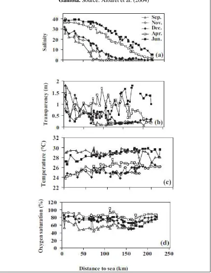
mesohaline (5 to 18) according to Por’s classification (Por 1972). In the dry season, most of the estuary up to Elephant Island (162 km from mouth) becomes polyhaline (18 to 30) or mixoeuhaline (30 to 40). See Figure 5.
In general, water is very turbid in the Gambia Estuary. During the wet season, transparency decreases from the estuary mouth upstream, reaching values of
approximately 0.2 m in the upper parts of the estuary. During the dry season, however, the estuary becomes less turbid with transparency a mean value of 1.2 m in the upper estuary. Turbidity is known to have a major influence on estuarine fish and shellfish occurrence and distribution.
Turbidity may afford greater protection for juvenile fish from predators; it is generally associated with areas where there is an abundance of food; and it may provide an orientation mechanism for migration to and from the estuary (Blaber 2000). However, excessively high water turbidity has been shown to negatively affect fish egg survival, hatching success, feeding efficiency (mainly of filter feeders), growth rate and population size (Whitfield 1998).
The surface temperature of the Gambia Estuary is generally less than 1˚C higher than the bottom temperature (mean surface temperature 27.4˚C, mean bottom temperature 26.9˚C.
Dissolved oxygen was never a limiting factor for fish in the Gambia Estuary even in the bottom water layer. Oxygen values were lower during the peak flood in September in the intermediate parts of the estuary and higher in April, during the dry and cool season (Albaret et al., 2004).
2. Gambia Coastal Ocean – Upwelling: The 200 mile Exclusive Economic Zone of The Gambia is located near the warm equatorial counter current (Guinea Current) and the cool Canary current. Seasonal upwelling of cool deep ocean water off the coast of The Gambia is important for fish production. Seasonal variations in water temperature, determine the patterns of fish migrations (Mendy 1999).
The productivity of this region is further enhanced by influxes of nutrients from the adjoining rivers/estuaries in the sub-region which are transported throughout the water column due to the very active upwelling system prevailing in the area. The Gambia Estuary is a well-mixed (no thermal or saline spatial or temporal vertical stratification) and oxygenated system. Considerable seasonal variation in river flow results in marked changes to the aquatic environment.
Marine Biodiversity Assets of the Gambia
Gambia River Estuary
operation, employs traditional methods, and is under-exploited due to low levels of fisheries technologies. About 80% of artisanal catches are bonga or shad (Ethmalosa fimbriata). Some of the marine fish species caught in the river include threadfins (Polynemidae sp.), marine catfish (Arius sp.) and solefish (Cynoglossidae sp.). Other abundant species are African bonytongue (Heterotis niloticus), upsidedown catfish (Synodontis gambensis), bagrid catfish Auchenoglanis occidentalis), Labeo senegalensis and Chrysichthus furcayus (IRD 2004).
The 2004 study of fish populations in the Gambia River by the French Institute for Research and Development (IRD) in collaboration with the Fisheries Department dentified about 70 fish species within the river system and several of them, especially those belonging to Carangidae, Drepaneidae, Clupidae, Haemulidae, Polynemidae, Cichlidae, Scianidae, Cynoglossidae, etc, are of commercial significance. It is strongly believed that the fish resources of the River Gambia are still under exploited and improvements in fishing technology and techniques will allow for increased fish landings.
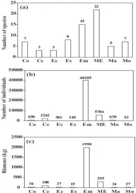
Seventy fish species, belonging to 32 families, have been recorded for the Gambia River Estuary (Table 2). The average number of species per family was low (2.18). This ratio was the lowest during November and highest in the dry season (April). The families with the highest species diversity were Carangidae and Sciaenidae (6 species each), Mugilidae (5 species), Clupeidae and Haemulidae (4 species each). With the exception of June when only 40 taxa were recorded, the species richness per survey remained relatively stable throughout the seasonal cycle between
49 (November) and 52 species (April). Family richness was also lower in June (22) and never exceeded 28 (November).
The Gambia Estuary fish fauna is dominated by the sciaenid Pseudotolithus elongatus (Table 2). The next three most abundant species were the clupeids Ethmalosa fimbriata, Ilisha africana and Sardinella maderensis. Synodontis gambiensis, the first continental species, was the fifth most abundant and fourth in terms of biomass. Two other
Siluriforms, S. batensoda and Schilbe intermedius, were also in the ten most abundant species.
There are a high number (15) of “estuarine of marine origin” species (Em), i.e. permanent inhabitants of estuarine communities that can complete their entire life cycle within estuaries. The clupeid Ethmalosa fimbriata and the sciaenid Pseudotolithus elongatus were the best representatives of the Em category in the Gambia Estuary. Though less numerous than the ME, the Em species were much more abundant in terms of individual numbers (Fig. 6) and biomass ( The top three dominant species in numbers, biomass and occurrence (P. elongatus, E. fimbriata, Ilisha africana, belong to this category.
Source: Albaret et al., 2004
the maximum flood period (September), this marine species was abundant in the upper reaches of the estuary. In addition, it breeds in the Gambia Estuary and all stages of the life cycle were represented in the system.
E. fimbriata, was second in terms of total fish numbers, biomass and occurrence, with biomass and occurrence less than half that of P. elongatus. Both juveniles and adults were recorded in seine net samples throughout the estuary. However, E. fimbriata shows a clear seasonal pattern: present in the lower reaches all year round and moving upstream only during the dry season. By December, a few subadult Ethmalosa were captured in the most upstream site (more than 220 km from the Ocean) in totally fresh water, but it was only in April, in a mesohaline environment (about 5 to 20) that the species became abundant in the middle and upper part of the estuary.
All the West African estuarine ecological categories are represented in the fish fauna of the Gambia River Estuary. Similarly, all of the main fish families likely to be found in tropical estuaries are represented in the Gambia system (Albaret 1999). In terms of the ecological
categories and life cycles it has a biodiversity close to or greater than that of many other estuarine systems in West Africa.
Figure 7. Fish abundance patterns vary with season in the River Gambia. (Albaret et al. 2004)
Gambian pink shrimp (Farfantepenaeus notialis). Southern pink shrimp is found from the Ivory Coast through Benin. As is true for most penaid shrimp, the pink shrimp’s breeds and spawns at sea and then larvae and post-larvae inshore move into estuarine environments—remaining there for three months depending on water salinity and
abundant even here). During the wet season, little shrimp fishing occurs in the upstream areas.
There are over 225 shrimp fishermen using two types of gear (stow nets and drift nets). Because of the small mesh sizes used (18 mm stow net), the bycatch rate of small fish is estimated to be in the realm of 5-10:1 (Lae et al. 2004). Existing regulations on minimum mesh size (25 mm) and minimum total length of the shrimp (35 mm) are not yet
enforced. Most of the shrimping occurs in remote inaccessible areas so regulations can only be enforced locally. Problems with the fishery include a decline of shrimp
processing facilities, restricted markets, poorly equipped shrimp landing sites, low financial capacity of shrimp fishers, and a lack of knowledge on the Gambia River shrimp population life-cycle. In the past, this fishery supported an export market. As a result of competition from farmed shrimp, however, shrimps are mostly sold to local hotels, markets, etc., and exported only within the region. Bycatch of juvenile fish and non-target species is a major problem and can represent 80-90% of a haul
Mollusks: Oysters and Cockles (Crassostrea gasar and Anadara spp. Murex spp. Cymbium spp.). Oyster harvesting is popular along both the north and south banks of the Gambia River. Wild oysters are gathered at low tide and from the roots of mangrove trees. The oyster harvesters also collect cockles from mud banks and mud areas between mangrove tree roots .The Department of Fisheries has noted a decline in the size and number of oysters harvested—a situation that has lead many Banjul-based harvesters to move to the North Bank, where the resource has been less exploited. Marketing and processing techniques for the oysters are simple—most are simply shucked, boiled and sold locally.
The Gambia oyster market chain and value-added processing is less developed than in Senegal. Currently in The Gambia, the only management measure in place is a closed season during the rainy season. There is no overall management plan specifically for oysters or cockles. Key issues in expanding markets are the need to: (1) better manage wild harvests, and (2) assess seafood sanitation issues. The latter includes looking at potential contamination of growing waters from human pathogens and at post-harvest sanitary processing practices.
Marine Mammals: Bottlenose is the most commonly sighted dolphin in Gambia waters and there may be a resident population in the river– being resident makes it more
The African Clawless otter (Aonyx capensis) as well as the Western Red Colobus Piliocolobus badius temminckii (EN according to IUCN Red List) occur in the Gambia River Estuary too.
Turtles/Reptiles: Bell’s hinged Tortoise Kinixys belliana has been recorded on the coastal strip, as well as the Nile crocodile Crocodylus niloticus in the Gambia River.
Birds/ Waterfowl: numerous migratory bird species – especially Western Reef-egret (Egretta gularis), Black-winged Stilt (Himantopus himantopus), Black-tailed Godwit (Limosa limosa), Grey-headed Gull (Larus cirrocephalus), Slender-billed Gull (Larus genei), Caspian Tern (Sterna caspia), and Royal Tern (Sterna maxima) stop on their seasonal migration. (Birdlife International 2007). An ecological survey in 1997 counted 362 species from 66 families of birds. A perimeter survey of TWC in December 2006 tabulated 85 species of birds and more than 7800 individuals. Eurasian species winter in the area and the tidal mudflats are crucial for their feeding before returning home to reproduce.
Mangrove Wetlands: These habitats occur well up the Gambia River, where the tidal influence extends as far as 460 km upstream.. A recent review of mangrove extent, found a reduction in Gambian mangrove extent from 66,500 ha in 1968 to 59,100 ha in 2000, a decrease of 11% in 32 years (FAO 2003).
There are seven mangrove species known in The Gambia River Estuary. Tall galleries of red mangrove (Rhizophora racemosa) border most saline waterways to the limits of daily tidal flooding. Mangrove woodlands composed primarily of black mangrove (Avicennia africana) are found beyond this frontage of tall trees, up to the mean limits of inundation by high “spring” season tides. The mangrove species Rhizophora harrisonii and R. mangle occur at the boundary between the R. racemosa and A. africana stands.
Rhizophora racemosa appears to be the primary “pioneer” successional species and in time is replaced by A. africana (Giglioli and Thornton 1965). White mangrove
(Laguncularia racemosa) is also present, albeit less common than the other species. Mangrove forests and related wetland habitats support a large number of important wildlife species, including West African manatee (Trichechus senegalensis), several dolphin species and numerous migratory bird species.
Endangered and Protected Species:
Endangered species in the Gambia River Estuary include:
• The West African manatee, which is listed as vulnerable by IUCN (2007).Both the Wildlife Conservation Act 1977 and the Biodiversity/Wildlife Act of 2003 mandate the protection of the species..
• The Western Red Colobus Piliocolobus badius temminckii (EN according to IUCN Red List).
• The Tortoise Kinixys belliana(CITES App. II),
Coastal/ Ocean
Fin Fish: There are over 500 marine fish species in Gambian waters. Fish species are usually classed as demersal and pelagic. The most important marine fish species are pelagic species, including shad or bonga (Ethmalosa spp.) and sardinellas (Sardinella spp.), but there are also appreciable stocks of both demersal and semi-pelagic species, such as carangids (Carangidae); barracudas (Sphyreanidae); croakers and drums (Sciaenidae); porgies and seabreams (Sparidae); groupers and seabasses (Serranidae); threadfins and tasslefishes (Polynemidae); and grunts (Pomadasysidae). The demersal fish group has a wide and diverse range of species and this include, cephalopods
(cuttlefish and octopus), shrimps and lobsters, groupers, sea breams. Grunts, croakers are demersal fish species. The small pelagics group consists of the two sardinellas
(Saridnella aurita and Sardinella maderensis), horse mackerels (Trachurus trecae, Trachurus trachurus and Caranx rhoncus) and mackerel (Scomber japonicas).
Mammals: Coastal waters of The Gambia and Senegal are clearly important for at least seven species of cetaceans: short-beaked common dolphin (Delphinus delphis), long-beaked common dolphin (Delphinus capensis), bottlenose dolphins (Tursiops truncatus), Atlantic humpback dolphin (Sousa teuszii), Clymene dolphin (Stenella clymene), harbour porpoise (Phocoena phocoena), and Bryde’s whale (Balaenoptera brydei) (Van
Waerebeek 2003).
Turtles: At least four species of marine turtles occur in The Gambia including green (Chelonia mydas), leatherback (Dermochelys coriacea), hawksbill (Eretmochelys imbricata) and olive ridley (Lepidochelys olivacea). Green turtles are by far the most common and abundant; the latter three turtles are rarely recorded. While loggerhead turtle (Caretta caretta) may also occur; its presence was not decisively confirmed in a recent study (Barnett et al. 2004). Unfortunately, at present little is known about the biology and conservation status of marine turtle populations in The Gambia.
Birds/ Waterfowl: the coastal mangroves, wetlands and associated ecosystems of The Gambia provide extremely critical habitats for a wide variety of migratory and non-migratory bird species. Bird Life International has identified no fewer than 13 “Important Bird Areas” in the country, of which ten fall within the coastal zone. Bird watching is becoming an increasingly important part of the tourist trade in The Gambia, providing solid economic incentive for conserving the habitats and species upon which this trade depends.
Direct Threats to Marine Biodiversity in the Gambia
Overfishing
The unregulated and excessive removal of finfish from the coastal ocean of the Gambia is a major threat to marine finfish biodiversity.
Figure 8. Status of main stocks of fish in Gambian Coastal Waters Species/Stock Status Year of
assessment
Reference
Small Pelagic Fish Sardinella aurita/NW
Africa
O 2008 FAO SPWG NWA (2008)
Sardinella maderensis N A 2008 FAO SPWG NWA (2008)
Ethmalosa fimbriata N A 2008 FAO SPWG NWA (2008)
Scomber japonicus O 2008 FAO SPWG NWA (2008)
Trachurus trecae F 2008 FAO SPWG NWA (2008)
Caranx rhoncus O 2008 FAO SPWG NWA (2008)
Demersal Fish
Pagellus belottii O 2007 FAO/CECAF DEM_WG
(FAO, 2008)
Arius spp O 2007 FAO/CECAF DEM_WG
(FAO, 2008)
Pseudotolithus spp F 2007 FAO/CECAF DEM_WG
(FAO, 2008)
Epinephelus aeneus O 2007 FAO/CECAF DEM_WG
(FAO, 2008)
Penaeus notialis F 2007 FAO/CECAF DEM_WG
(FAO, 2008)
Octopus vulgaris O 2007 FAO/CECAF DEM_WG
(FAO, 2008)
O – over-exploited ; F – fully exploited; NA – inconclusive assessment
Population growth, poverty, coastal development, government bureaucracy and commercial fishing are threatening the marine resources off the coast of The Gambia. Several species that are caught as by-catch have become extremely rare (eg.:
(deliberate and incidental catch by gillnets, trawlers and other fishing gears, over-exploitation of turtle eggs and meat), and indirect (pollution, destruction or degradation of the nesting and foraging habitats). Artisanal fishermen have been known to
purposefully capture adult turtles in known foraging grounds on days when their fishing captures are low.
Sardinella (Sardinella spp). Two species comprise the sardinella fishery—the round sardinella (Sardinella aurita) and the flat sardine (Sardinella maderensis). Although both are migratory, the flat sardine is found closest to shore and is more vulnerable to capture by the artisanal fleet. In 2006, over 3,685,178 kg of flat sardine were landed in the Atlantic stratum while only 933,013 kg of round sardine were landed (Department of Fisheries 2006 Catch Assessment survey report). Most of the round sardines are captured by the industrial fishermen and there is little infrastructure to handle processing on shore, so few boats land their catch in The Gambia. The last stock assessment performed by the working group of the FAO-CECAF (2008) lists the sardinella species as overexploited. However, the poor data quality affects the certainty of this conclusion. Abundance and distribution of sardinellas are primarily controlled by environmental factors affecting oceanographic conditions with upwelling and water retention over the Northwest African shelf (Zeeberg et al., 2008). The FAO working committee recommended that catches for sardinella spp. in the sub-region (Morocco to Senegal) should not exceed 200,000 tons (200,000,000 kg) and that fishing effort be reduced by 50%.
The flat sardine is mostly harvested by artisanal fishermen using surround gill nets and purse seines (purse seine specifications are: length 600-700 m; depth 45-50 m; mesh sizes—belly of 24-26 mm and bunt of 30-40 mm). The Gambian management plan proposes a minimum mesh size in the bunt of no smaller than 40 mm. An estimated 50% of catch is bycatch (small fish), which is often discarded or sold to fish dryers. The Department of Fisheries proposes efforts to limit the amount of bycatch to no more than 5% of total landed catch.
At present, there are 12 permanent purse seine operators at Tanji and seven at Gunjur. However up to 80 migratory operators from neighboring countries frequent the fishing grounds and may land their catch in The Gambia. Each vessel has the capacity to land 5 tons of sardinella per trip. Other regulatory actions proposed include: limit to a day-time fishery only on a daily basis; a maximum limit of five migratory boats allowed to operate in any one of the sites.
Gambian Sole: (Cynoglossus senegalensis). Gambian sole (Senegalese tongue sole) is harvested by approximately 475 artisanal fishermen. The fishermen operate less than 1 nm from shore—where the sea floor is flat, sandy or muddy. Sole is harvested year-long with bottom-set gill nets (length 600-700 m; depth 1-1.5 m; in segments of 40 m each; with 20 kg of lead on ground ropes set with anchors; mesh size of 80 mm). Other fishermen use drift nets, hook and line, long-line and traps to harvest the sole.
species was made in 1986. However, the CPUE of sole declined noticeably in 2006 and 2007, pointing to a clear need to control fishing effort.
Sole is a high value product and is primarily destined for export to the EU. Recently (2008), the Marine Stewardship Council (through Food Certification International Limited) conducted an assessment for certification. This is being done under a new category called Small-scale/Data Deficient fisheries. This assessment utilizes a risk based precautionary approach intended to compensate for little or no data being available. This initial audit pointed to a number of improvements that need to be made before the fishery can be certified as fished sustainably. The Program will support implementation of management actions proposed by the Gambian government: (1) a proposed reference point of 25 cm minimum length until more data is generated, (2) a minimum mesh size of 80 mm, and (3) a prohibition on the use of drift nets.
By-catch
By catch of marine turtles, sharks (for fins), cetaceans, and undersized fin fish is occurring in the Gambia . Shrimp and other "good quality" fish are sold to hotels and restaurants by prior arrangement, sole and cuttlefish are of particular interest to some middlemen and most of the fin fish catch is sold direct to consumers or through middlemen on the beach. (Jallow 1995; Van Waerebeek, 2003). See Figure 9.
Figure 9. Species in shrimp trawler catch in Gambia. (Source: Jallow 1995)
Scientific name English name
Pseudotolithus typus Long neck croaker
Pseudotolithus brachynathus Law croaker
Pseudotolithus senegalensis Cassava croaker
Fonticulus elongates Bobo croaker
Plectorhyncus mediterraneus Rubberlip grunt
Pomadasys jubelini Sompat grunt
Epinephelus aeneus White grouper
Epinephelus guaza Dusky grouper
Polydactylus quadrifilis Giant African threadfin
Galeoides decadactylus Lesser African threadfin
Sepia spp Cuttlefish
Arius heudeloti Smooth mouth sea catfish
Sphyraena spp Barracuda
Penaeus notialis Shrimps
Drepane Africana African sickle fish
Cynoglossus senegalensis Sole fish
Cybium spp Snail
Data provided by Jallow suggests that of the non-shrimp catch the African threadfins, croakers, grunts, sole fish and African sickle fish make up the major part of the by-catch. Barracuda and cuttle fish are relatively rare and seasonal. The Cybium spp have become the subject of specialized processors being fermented and exported to Senegal where they are in high demand.
Harvesting of Mangroves:
Mangroves are harvested for fuel wood supplies, construction materials, food production and other needs. Cutting down of mangroves for social and economic purposes culminate into loss of habitat; nursery and refuge area for important fish species and other fauna. The mangrove systems provide important revenue in terms of oyster and shrimp culture.
Sand Mining and beach development
Mining of beach sand occurs constantly by the dump truck load and taken to communities for construction of houses, walls, roads. Tourism development along the beach with the resultant lights at night and increase in people on the beach is reputedly denying sea turtles access to nesting sites. With the result that sea turtles now only nest on the off-shore bird island sanctuaries.
Indirect Threats to Marine Biodiversity in the Gambia
Human Population Growth
Biodiversity resources in the region face considerable and increasing pressure from a human population expected to grow at an annual rate 3-4% into the foreseeable future (FAO 2001, DPWM 1998) and nearly double to 2 million people by the year 2025 (WRI 2007).Coastal systems are under particular threat: 91% of The Gambia’s population lives within 100 km of the coast (WRI 2007), and these coastal populations are increasing in number and density (Manneh et al. 1994). Urban encroachment, industrial development, increasing agricultural activities, fuel-wood extraction and over-harvesting have all been cited as threats to the Tanbi Wetland Complex, a recently designated Ramsar Site within the vicinity of Banjul in the Western Division (Cham et al. 2002, BirdLife International 2007, Hirani 2005).
Global Climate Change:
The Gambia River is one of the last aquatic ecosystems in West Africa that has not yet been affected by strong environmental changes and human disturbances. Yet a dam is being proposed on the main stem of the Gambia River in Guinea to ensure fresh water for agriculture and hydropower as global warming puts stresses on these resources. The dam will have major impacts on the river ecosystem and species in it. Shrimps, Grouper, and Ladyfish are found in depths of less than 100m, cannot tolerate low oxygen in waters of below 20% oxygen saturation with maximum temperature of 35oC. Warming of more than 3oC to 5oC will have negative impact on their productivity.
Coastal fish that are classified as high valued species may also be negatively impacted by increases in temperature. These bring better returns to the fishermen as exports/livelihood diversification and their loss will threaten food security as well. Therefore, there is need to adopt climate change adaptation measures in order to obtain and maintain a healthy fishery stock.
Accelerated sea-level rise resulting from global warming (IPCC 2001) has important implications that increase the threats to marine biodiversity in the Gambia.. As well as the increasing desertification of the Sahel (which may lead to further increases in coastal populations), there is likely to be an increase in coastal erosion and inundation of what are now densely populated low-lying areas, such as the Victoria Island beaches in Lagos, Nigeria, and the Greater Banjul Area in Gambia (Jallow and others 1996, UNEP 1999).
Weak Governance Capacity
isolation rather than adopting a holistic approach in formulating and implementing policies. Even in the event where these institutions have formulated appropriate policies to address existing problems, there has always been the big problem of enforcement as a result of either shortage of the required manpower or resources”.
The overall situation is that most NGOs, Civil Societies and National Institutions have weak capacities and require assistance in capacity building. The situation is more critical for those small NGOs and national institutions who are often constrained by lack of financial and human resources. As key stakeholders in the natural resources management, NGOs and civil society organizations could greatly contribute to the country’s overall development if their capacities are enhanced.
Official Priorities for Conservation of Marine Biodiversity in the Gambia
The principal institutions involved in the conservation and the management of the coastal environment in the Gambia are: i) National Environment Agency, ii) Department of Fisheries, iii) Department of Forestry, iv) Department of Parks and Wildlife Management and v) the Department of Tourism. These institutions by way of their mandate are very active in the coastal zone. Although sectorally fragmented, these public institutions have promulgated into laws, environmental protection and management along the coastline of the Gambia.
The GEAP provides a framework for national environmental policy and, planning and decision making for natural resources management. The policy objectives of the GEAP directly support the conservation and sustainable use of biodiversity. Correspondingly, different sectors have set different sector specific policy goals and objectives and long-term sector strategies that are relevant to the conservation and sustainable use of biological diversity. Some of the relevant sectoral policy objectives for the management of the coastal environment include the following:
• Environment Sector: To control environmental degradation and pollution in both natural and human ecosystems through firm regulations and application of Environment Impact Assessment (EIA).
• Wildlife Sector: To establish national parks and nature reserves covering at least 5% of the national land area for the conservation, protection and management of the fauna and flora with a view to improving the management capacity of the DPWM and increase revenue generation from wildlife resources.