Small Format Optical Sensors for Measuring
Vegetation Indices in Remote Sensing Applications:
A Comparative Approach
Mona Arif Muda, Alban Foulonneau, Laurent Bigu´e
Laboratoire MIPS - EA2332, ENSISAUniversit´e de Haute-Alsace Mulhouse, France [email protected]
Harry Sudibyo, Dodi Sudiana
Department of Electrical EngineeringUniversitas Indonesia Depok, Indonesia [email protected]
Abstract—In this paper we report the comparative study of two types of digital cameras to be used for vegetation index measurement. Using either a dedicated multispectral JAI AD-80-GE camera or a custom dual Canon S3IS camera system, we obtained RGB and NIR images and processed them to obtain vegetation indices (NDVI, EVI and two-band EVI). Since no radiometric calibration is available for both systems, normalized reflectance images are not available and we have to determine relative gain factors for the various bands in order to get likely vegetation indices. Moreover, the two camera system requires image registration. Experimental results are provided.
Index Terms—vegetation indices, multispectral camera, remote sensing.
I. INTRODUCTION
Research in multispectral remote sensing using optical sen-sors for agriculture [1] has proven to get the characteristics of plants that influence reflectance and emission of electro-magnetic energy. Reflectance differences between the plant leaves over the 0.5-1.4 micron range are caused principally by Fresnel reflections at external and internal leaf surfaces and by plant pigment absorption [2]. Measurements with a spectrophotometer made on the leaves showed that the largest increase in reflectance, about 5%, and decrease in transmittance, about8%, occurred between average values for after-tagging-ages of cotton leaf over the 0.75-1.35-micron wavelength interval [3].
Broad-band red/near-infrared vegetation indices such as Leaf Area Index (LAI) and Normalized Difference Vegeta-tion Index (NDVI) are measures of chlorophyll abundance and energy absorption which influence plant growth through photosynthesis [4]–[6].
Whereas most acquisition systems are embedded in satel-lites, some researchers also made measurements of LAI and NDVI using airborne systems. By using airborne multispectral images, Boegh et al. [7], [8] found that nitrogen concentrations
Directorate General of Higher Education (DGHE) Indonesian and France Embassy in Indonesia
(mass basis) are linearly related to spectral reflectance in the green and far-red spectral bands. Furthermore the development of the mosaicking technique using Unmanned Aerial Vehicle (UAV) [9] will provide an option in the development of low altitude and high resolution vegetation index mapping.
Our research focuses on studying the use of optical sensors to measure the vegetation indices and which are to be placed in UAV systems. We aim at providing images of vegetation indices in rather high spatial resolution (comparing to satellite sensors) for optical remote sensing. Our acquisition system has to be compact and lightweight enough to be portable. In this paper we are presenting and comparing two solutions. The first one uses two standard compact digital cameras, the Canon S3-IS. We modify one of them adding an internal filter in order to obtain the NIR information. The second solution consists in using a single dedicated multispectral camera, manufactured by JAI company.
II. THEORETICAL APPROACH
A. Calculation of Vegetation Indices
Several metrics can be considered for studying vegetation. Among them, the most popular ones are:
N DV I=N IR−R
EV I stands for enhanced vegetation index andEV I2 stands for two bands enhanced vegetation index without blue band, and where NIR, R and B represent normalized surface re-flectances averaged over ranges of wavelengths in the near-infrared (λ ∼ 0.8µm), visible red (λ ∼ 0.6µm) and visible
blue (λ ∼ 0.4µm) regions of spectrum, respectively. G is a
gain factor,C1andC2are coefficients of the aerosol resistance term,c=R/B, andLis the soil adjustment factor. In MODIS EVI algorithm, L= 1,C1= 6,C2= 7.5, andG= 2.5[10], [11].
B. Spatial Resolution
There are reports of producing a 1 km spatial resolution land cover classification using data from the Advanced Very High Resolution Radiometer (AVHRR). The methodology was derived from a similar effort to create a product at 8 km spatial resolution, where high resolution data sets were interpreted in order to derive a coarse-resolution training data set [12]. Some researches also compare some different types of small format multispectral sensors, ones are commercially available systems, and the others are custom built systems [13], [14]. In this study we focus on the use of cameras to be placed on UAV, so we chose JAI AD-80-GE as a dedicated multispectral camera, and a custom built system made of two Canon S3IS cameras. The selection of these two types of cameras is related to their weight and dimensions that allow them to be placed in the fuselage of the UAV. With our final device we aim at producing images at less than 1 meter spatial resolution.
III. THE SENSORS AND USED METHODS
A. Dedicated Multispectral Camera
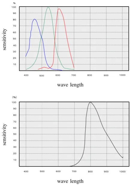
The JAI AD-080-GE is a multispectral camera that allows the combined use of visible and near-infrared light inside one camera. The 2-CCD system allows the simultaneous imaging via two channels and one objective lens. A CCD sensor with Bayer Mosaic color filter is used to filter the visible light, and a monochrome CCD sensor is used for NIR-light. The light beams of both spectrums are separated using a special dichroic prism and sensed by the corresponding sensors. The spectrum responses of the two sensors in the camera are shown on Fig. 1. Using a single lens system, this camera produces two precise geometric images which do not need to be registered.
B. Multispectral System using two Modified Cameras
For having visible and near-infrared light from common digital camera, we use two Canon S3-IS digital cameras. The first camera is used for acquiring visible light and the second camera for acquiring near-infrared light. These two cameras use 1/2.5” CCD sensor, providing 2816 x 2112 resolution images. The camera type selection is based on the consideration of the quality of images output and the weight / dimensions for utilizing camera in the airborne system, or unmanned aerial vehicle. Unfortunately we do not have the spectrum response of the Canon camera to our disposal. Modification for spectrum sensitivity has been made for the second camera by replacing visible light filter lens with infra-red filter lens inside the camera. We use an IR-72 compatible filter lens as the infra-red filter lens. With this filter, the second camera becomes sensitive to infra-red spectrum. As shown in Fig. 2, we also have made modification for operating the two cameras with the remote control aeromodeling system (radio controlled). Due to spatial lag between two images produced by the cameras, the corresponding images have to be registered before they get in the vegetation index formulas. And we use piecewise linear mapping function for registering the two images [15].
Fig. 1. Spectrum response for the two sensors in JAI AD-080 GE camera.
On the top, sensitivity for RGB sensor, on the bottom for the IR one.
Fig. 2. The two Canon cameras and their controller.
IV. COMPARISON METHODS
TABLE I
CHARACTERISTICS OF THE TWO SYSTEMS
Parameters JAI AD-80-GE Modified Canon S3-IS
System base 2 CCD sensors (visible
and NIR), single lens
2 cameras with two
identic CCD sensors,
one lens per camera Resolution
(max) 1024×768pixels 2816×2112pixels
Operating
sys-tem PC shutter
Microcontroller board
shutter
Power supply 12 volt DC 4×AA batteries
Weight 320 g + 60 g (lens) 2×410 g
Memory
storage PC by Gige interface SD Card Memory
TABLE II
SETTINGS OF THE TWO SYSTEMS FOR OUR EXPERIMENTS
Settings JAI AD-80-GE Modified Canon S3-IS
Resolution 1024×768pixels 2816×2112pixels
Shutter speed 1/250 s for RGB
1/60 for NIR 1/1250 s
Focal length 8 mm 6 mm
Aperture f/16 f/8
captured images: for Canon system we set exposure time manually, and for JAI system we did it automatically with a script to avoid the saturation and get the best shutter speed. These images were acquired in the city of Mulhouse, France, in the spring season on a sunny day. The characteristics of the two systems are shown in Table I, we set some parameters as shown in Table II.
Begin JAI AD-80-GE
Begin
Modified Canon S3IS
Setting - Apperture - Shutter speed
Take a snapshot
Saturation check
End Vegetation index processing
End Vegetation index processing
Image registration Setting - Apperture - Shutter speed
Take a
Fig. 3. Image capturing flowchart for the two systems.
V. RESULTS
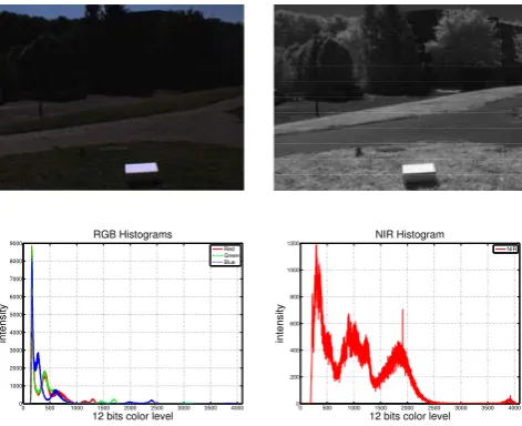
We successfully obtained RGB and NIR images with both types of systems (Fig. 4 and Fig. 5). NIR images from the modified NIR Canon camera is taken from red band of RGB sensor.
8 bits color level
intensity
8 bits color level
intensity
NIR
Fig. 4. Visible and near-infrared raw images from modified Canon S3IS.
0 500 1000 1500 2000 2500 3000 3500 4000 0
12 bits color level
intensity
Red Green Blue
0 500 1000 1500 2000 2500 3000 3500 4000 0
12 bits color level
intensity
NIR
Fig. 5. Visible and near-infrared raw images from JAI AD-80-GE.
Nevertheless, computation of the various vegetation indices mentioned in Sec. 2 must be done carefully. Actually, the images we acquire are not normalized reflectance images, as requested. Moreover, since our sensors have no radiometric calibration, computing the indices with non-normalized images would lead to obvious errors.
EV I2 =G kN I RN IR−R
kN I RN IR+ (C1−C2/c)R+L
(6)
In our experiments, in order to get low cost reflectance reference, as [16] use white ceramic tile for reflectance standard instead of using spectralon, we use white paper as our reflectance reference to acquire reflectance factor for red, NIR and blue bands in both systems (JAI sensors and Canon sensors). Then we compute the coefficientskN I Rfor NIR band andkB for blue band for each system. With such calibration, vegetation index images are correct.
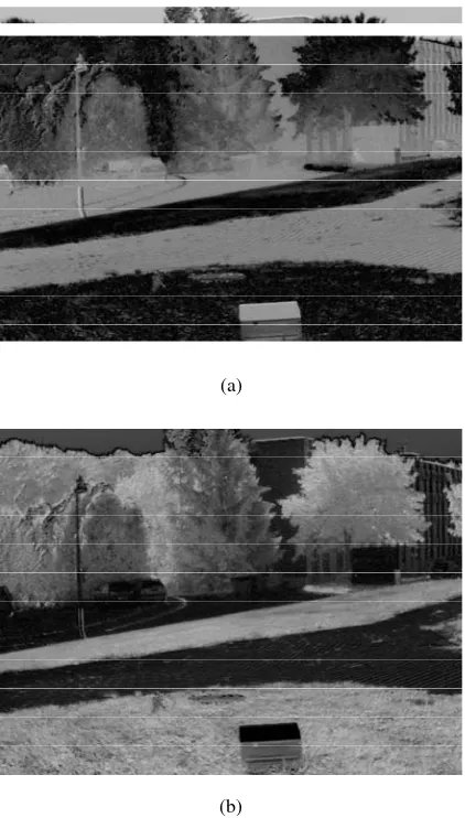
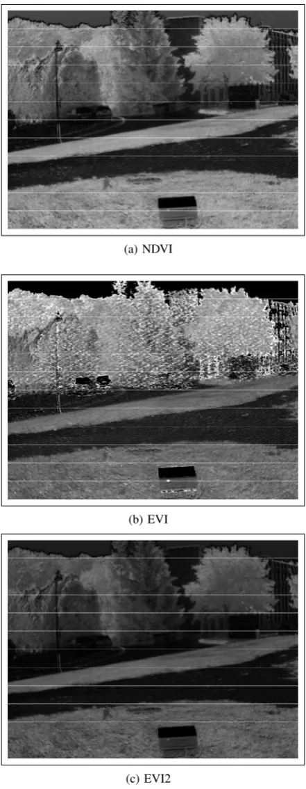
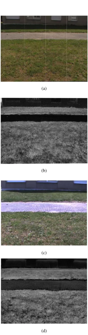
In Fig. 8 and Fig. 9 are shown the indices computed from the raw images of the scenes presented Fig. 4 and Fig. 5, after we have performed the registration of the Canon images and have performed the calibration in both cases. In the scene, we have grass, some different types of trees, buildings and pavement. We also can notice a box covered with white paper on its top: it is our reflectance reference. The greener the vegetation in the scene, the brighter it appears in vegetation index images.
Since the Canon system provides 8-bit images, parts of the indice images can be very noisy. In order to illustrate it, we present an acquisition of another scene Fig. 10. We have images of the same scene taken with our two systems. As we can see Fig. 10(b) in the region with low light (shadow at the bottom of the building) vegetation index appears very noisy. With the 12-bit JAI camera, this is not the case Fig. 10(d).
0 500 1000 1500 2000 2500 3000 3500 4000 0
5000 10000
15000 RGB Histograms
12 bits color level
intensity
Red Green Blue
0 500 1000 1500 2000 2500 3000 3500 4000 0
500 1000 1500 2000
2500 NIR Histogram
12 bits color level
intensity
NIR
Fig. 6. Visible and near-infrared images from JAI AD-80-GE after calibra-tion.
VI. CONCLUSION
We successfully implemented the production of vegetation index images using two architectures. A custom system made of two end-user cameras was shown to produce high-resolution images. Such a relatively inexpensive system, currently using 8-bit sensors, produces noisy images, and these images need to be registered. An alternative may consist in using a multi-spectral RGB/NIR camera such as JAI AD-80-GE. It produces
(a)
(b)
Fig. 7. Illustration of the calibration benefits. (a) result obtained by
computing NDVI with the raw images presented Fig. 5. (b) result obtained after calibration with the calibrated images presented Fig. 6
moderate resolution images, but these latter prove high quality with their 12-bit depth.
In the growing of aerial imaging applications using airborne systems and unmanned aerial vehicle, it will be very good if camera manufacturers can provide multispectral cameras with portable features such as control systems, power supply and memory storage.
ACKNOWLEDGMENT
The authors would like to thank Prof. Timothy Stombaugh and his team in Department of Biosystems and Agricultural Engineering in University of Kentucky, USA, Unila Robotika dan Otomasi (URO) research group in Universitas Lampung, Indonesia.
REFERENCES
(a) NDVI
(b) EVI
(c) EVI2
Fig. 8. Computation of vegetation indices with images from the Canon
3SIS system. Indices images are not rectangular because of the registration we performed on RGB and IR images.
[2] W. A. Allen, H. W. Gausman, A. J. Richardson, and C. L. Wiegand, “Mean effective optical constants of thirteen kinds of plant leaves.”
Applied optics, vol. 9, no. 11, pp. 2573–2577, 1970.
[3] H. W. Gausman, W. A. Allen, R. Cardenas, and A. J. Richardson,
(a) NDVI
(b) EVI
(c) EVI2
Fig. 9. Computation of vegetation indices with images from the JAI
AD-80-GE.
“Relation of light reflectance to histological and physical evaluations of cotton leaf maturity.”Applied optics, vol. 9, no. 3, pp. 545–552, Mar. 1970.
Transactions on, vol. 33, no. 2, pp. 481–486, Mar. 1995.
[5] M. A. Friedl, F. W. Davis, J. Michaelsen, and M. A. Moritz, “Scaling and uncertainty in the relationship between the NDVI and land surface biophysical variables: An analysis using a scene simulation model and data from FIFE,” Remote Sensing of Environment, vol. 54, no. 3, pp. 233–246, Dec. 1995.
[6] G. A. Blackburn and C. M. Steele, “Towards the remote sensing of ma-torral vegetation physiology: Relationships between spectral reflectance, pigment, and biophysical characteristics of semiarid bushland canopies,”
Remote Sensing of Environment, vol. 70, no. 3, pp. 278–292, Dec. 1999. [7] E. Boegh, H. Soegaard, N. Broge, C. B. Hasager, N. O. Jensen, K. Schelde, and A. Thomsen, “Airborne multispectral data for quantify-ing leaf area index, nitrogen concentration, and photosynthetic efficiency in agriculture,”Remote Sensing of Environment, vol. 81, no. 2-3, pp. 179–193, Aug. 2002.
[8] E. Boegh, H. Soegaard, A. Thomsen, and S. Hansen, “Multi-scale remote sensing based estimation of leaf area index and nitrogen concentration for photosynthesis modelling,” Igarss 2003: Ieee International Geo-science and Remote Sensing Symposium, Vols I - Vii, Proceedings: Learning From Earth’s Shapes and Sizes, pp. 2847–2849, 2003. [9] A. Birk, B. Wiggerich, H. Bulow, M. Pfingsthorn, and S. Schwertfeger,
“Safety, security, and rescue missions with an unmanned aerial vehicle (UAV) aerial mosaicking and autonomous flight at the 2009 european land robots trials (ELROB) and the 2010 response robot evaluation exercises (RREE),” Journal of Intelligent & Robotic Systems, vol. 64, no. 1, pp. 57–76, 2011.
[10] T. N. Carlson and D. A. Ripley, “On the relation between NDVI, fractional vegetation cover, and leaf area index,” Remote Sensing of Environment, vol. 62, no. 3, pp. 241–252, Dec. 1997.
[11] Z. Y. Jiang, A. R. Huete, K. Didan, and T. Miura, “Development of
a two-band enhanced vegetation index without a blue band,” Remote
Sensing of Environment, vol. 112, no. 10, pp. 3833–3845, 2008. [12] M. C. Hansen, R. S. Defries, J. R. G. Townshend, and R. Sohlberg,
“Global land cover classification at 1km spatial resolution using a classification tree approach,”International Journal of Remote Sensing, vol. 21, no. 6-7, pp. 1331–1364, Apr. 2000.
[13] P. M. Dare, “Small format digital sensors for aerial imaging
appli-cations,” The International Archives of the Photogrammetry, Remote
Sensing and Spatial Information Sciences, vol. XXXVII, pp. 533–538, 2008.
[14] G. Rabatel, N. Gorretta, and S. Labb, “Getting NDVI spectral bands from a single standard RGB digital camera: A methodological approach,” Dec. 2011.
[15] A. Goshtasby, “Piecewise linear mapping functions for image registra-tion,”Pattern Recognition, vol. 19, no. 6, pp. 459–466, 1986. [16] I. D. Sanches, M. P. Tuohy, M. J. Hedley, and M. R. Bretherton, “Large,
durable and low-cost reflectance standard for field remote sensing applications,”International Journal of Remote Sensing, vol. 30, no. 9, pp. 2309–2319, 2009.
(a)
(b)
(c)
(d)
Fig. 10. NDVI comparison of the same scene acquired.(a) RGB scene