Oceanography
Vol. 18, No. 4, Dec. 2005 42Progress
in
Oceanography of the
Indonesian Seas
a marked advance in our understand-ing of Indonesian seas oceanography. This progress is a result of the grow-ing interest of the oceanographic com-munity in the unique characteristics of these tropical seas (see Gordon, this issue) and the support and openness of the Indonesian government to interna-tional scientifi c collaborations. The pace of research is also accelerating due to the application of new technologies (in situ observational methods and satelliteimagery) and by increased communica-tion among scientists brought about by the Internet. In the early days, studies of the ocean were made for navigational purposes. Increasingly, the economic importance of marine resources is being recognized and climate prediction en-courages continued research.
The evolution of oceanography of the Indonesian waters is clustered into three major periods: pre-colonial (from earli-est recorded history until the end of the 16th century), colonial (from the
begin-ning of the 17th century to Indonesian independence in 1945), and post-inde-pendence (from 1945 to 2000). Van Aken (this issue) discusses the colonial period in detail. Here we focus on the earlier and later periods.
T H E P R E CO LO N I A L P E R I O D The pre-colonial period begins with the earliest recorded history and continues until the presence of western colonial-ism at the end of the 16th century. Dur-ing this period, pre-Indonesian history
Th
rly journal of Th
e O
, MD 20849-1931, U
SA
was marked by two golden ages. The fi rst golden age was between 863 and 1225 AD when the maritime south Su-matran Kingdom of Sriwijaya ruled over the entire island of Sumatra and the western part of the present Indo-nesian region. The second golden era was between 1293 and 1389 under the eastern Javanese Kingdom of Majapa-hit. To maintain their hegemonies, these two kingdoms required strong mari-time powers. Pariwono (1986) postu-lated that these empires would have had
“oceanographers” who were expert in tidal information and ocean currents of the Southeast Asian and adjacent wa-ters, because this knowledge would have been essential to effi cient operation of their wind-powered fl eets. Accordingly, knowledge of the physical oceanogra-phy of the Indonesian seas in this period was limited to tides, monsoon-driven currents, and ocean circulation. Unfor-tunately, carefully compiled records of these kingdoms are scarce (Robertson and Spruyt, 1967), and none of these
remnants deals with scientifi c matters. A kind of wooden ship existed during the Sriwijayan time as depicted from a relief on the wall of the Borobudur temple in Central Java (Figure 1).
To achieve his vision of becoming a maritime empire spanning the oceans, the Emperor of the Ming Dynasty of China, Zhu Di, appointed the Grand Eunuch, Cheng Ho (Zheng He), to be-come Commander-in-Chief of the larg-est fl eet (over 300 ships) ever built at that time (Menzies, 2003). In his fi rst voyage
Oceanography
Vol. 18, No. 4, Dec. 2005 44in the Asian waters from 1405 to 1407, Cheng Ho visited Java and Sumatra, and from there went to Sri Lanka and India. His fl eet started its expedition in 1421, cruising southward to the South China
Sea through the Malacca Strait into the Indian Ocean. Returning to China via Australia, part of the fl eet under the command of the Chinese Admiral Zhou Man sailed through the eastern waters (possibly the Banda Sea) to visit Ambon, Ternate, and Tidore for spices and exotic food from the seas, such as sea cucum-bers (Menzies, 2003). It is thought that the armada started their voyage along sea lanes they were familiar with before em-barking into unknown waters. The com-mander would have gathered suffi cient
information regarding the currents and tides of the waters between Beijing and the Strait of Malacca. The source of this oceanographic information, particularly that of the Southeast Asian waters, likely
originated mostly from the Sriwijaya and Majapahit kingdoms.
THE COLONIAL PERIOD
The colonial period (the beginning of the 17th century until Indonesia gained independence in 1945) is when western countries occupied most of the South-east Asian region, and detailed observa-tions of marine biology and physical oceanography of the Southeast Asian and adjacent waters were recorded. Be-ginning in 1768, when the Boudeuse and Etoile Expedition from France made some measurements in the East Indies (now Indonesian) waters, several coun-tries sent oceanographic expeditions to this region. About 38 expeditions were carried out within a span of 173 years (Pariwono, 1986; van Aken, this issue), including expeditions by the following ten countries: Austria (1 expedition), Britain (10), Denmark (1), The Nether-lands (8), France (10), Germany (3), Italy (1), Japan (1), Soviet Union (1), and the United States (2).
Several important oceanographic features were observed during these expeditions, including: (1) water mass characteristics of the East Indies waters (van Riel, 1932, 1934, and 1938); (2) hy-drographic conditions of the Indonesian waters (Tydeman, 1903; van der Stok, 1922; Schott, 1935); (3) monsoon-driven currents in the Java Sea (Berlage, 1927); and (4) climate-related characteristics of the region (Braak, 1921). Note that van Riel (1932), using data from the Snel-lius Expedition, is considered to be the fi rst person to suggest that the transport within the East Indies waters is directed into the Indian Ocean. Furthermore, the Snellius Expedition contributed impor-tant data and information on hydrogra-phy and bottom topograhydrogra-phy of the deep eastern waters of the East Indies (van Riehl, 1934; Kuenen, 1935).
In 1905, the Netherlands East Indies government established a fi shery station at Pasar Ikan in Batavia (now Sunda Ke-lapa in Jakarta). Later, the fi shery station became the Laboratory for the Investiga-tion of the Sea, which was commissioned to promote marine research for fi sheries purposes. Hardenberg (1952) reported on the activities carried out from 1939 to 1950 by this laboratory. Monumental works that emerged during this period were by Bleeker with his publications of Atlas Ichthyologique in six large volumes (from 1819 to 1878); by Weber and de Beaufort (1911, 1913, 1916, 1922, 1929, 1931) with their publication of The Fish-es of the IndonFish-esian Archipelago; by van Bosse (1928) who studied marine bota-ny, particularly marine algae (succeeded by Zaneveld, 1950);and by Delsman (1939) who studied pelagic fi sh eggs and planktons. Note that Bleeker initiated the
John I. Pariwono ([email protected]) is Senior Lecturer and Researcher, Depart-ment of Marine Science and Technology, Faculty of Fisheries and Marine Sciences, Bogor Agricultural University (IPB), Bogor, Indonesia. Abdul Gani Ilahude is Senior Research Scientist, Center for Oceanograph-ic Research, Indonesian Institute of Sciences (LIPI), Jakarta, Indonesia. Malikusworo Hutomo is Senior Research Scientist, Center for Oceanographic Research, Indonesian In-stitute of Sciences (LIPI), Jakarta, Indonesia.
In the early days, studies of the ocean were made for
navigational purposes. Increasingly, the economic
fi rst scientifi c journal in Indonesia (i.e., Natuurkundig Tijdschrift voor Nederland-sch Indie [Nontji, 2005]).
THE POSTINDEPENDENCE PERIOD
This period begins when Indonesia be-comes independent in 1945 and ends at the beginning of the 21st century. On August 17, 1945, the former East Indies archipelagic region became offi cially known as Indonesia. After independence, the Laboratory for the Investigation of the Sea changed its name three times, from the Institute of Sea Research ( Lem-baga Penelitian Laut, 1950 to 1970s), to the National Institute of Oceanology (Lembaga Oseanologi Nasional, 1976 to 1999), to the Center for Oceanographic Research under the Indonesian Institute of Science (Pusat Penelitian Oseanografi , LIPI, 1999 to present).
From 1950 to 1956, Hardenberg (the director of the Laboratory for the In-vestigation of the Sea), together with Soeriaatmadja (a chemist from the same laboratory), collected observations on the surface salinity and temperature of the entire Indonesian and adjacent wa-ters. The Royal Dutch Shipping Com-pany collected salinity samples monthly along their regular sailing tracks with the assistance of the ships’ captains and crew. These samples were analyzed at the Laboratory and the results published by Veen (1953) and Hardenberg and Soeri-aatmadja (1956). Results from these analyses was further utilized by Wyrtki as part of his studies on monthly aver-age surface salinity distribution in the Indonesian and adjacent waters (Wyrtki, 1957, 1961).
In 1950, the laboratory received its
fi rst research vessel, the R/V Samudera (see Wyrtki, this issue), a 25-m-long ship equipped with Nansen bottles, revers-ing thermometers, and oceanographic wires for marine surveys. This vessel was used to collect west monsoon hy-drographic data (Wyrtki, 1958, 1961). In 1961, the laboratory (then the Insti-tute of Sea Research) received another oceanographic vessel, the 60-m-long R/V Jalanidhi. With this ship, the Institute of Sea Research participated and made a contribution to the International Indian Ocean Expedition (Wyrtki, 1971). This ship was also part of the national expedi-tions of Baruna I in 1965 (Ilahude, 1964; Rahardjo and Ilahude, 1965) and Baruna III in 1970 (Ilahude, 1970a,b, 1998) that carried out hydrographic measurements in the eastern Indonesian seas.
It is interesting to note that the num-ber of scientifi c expeditions conducted within this relatively short post-in-dependence period (a time span of
45 years) is almost twice that of the previous period (the colonial period, which spanned 173 years). During the post-independence period, 75 expedi-tions took place, whereas in the colonial period only 38 occurred. Since 1945, Indonesia conducted 40 out of the 75 expeditions, including the International
Indian Ocean Expedition, the Coopera-tive Study of the Kuroshio, and the six PELITAs (the Indonesian fi ve-year de-velopment programs from 1969 to 1999, known as PELITA Expeditions I-VI). During these expeditions, shipboard sci-entists measured hydrographic, chemi-cal, biologichemi-cal, and physical oceano-graphic parameters related to fi sheries activities in Indonesian and adjacent waters. For detailed description of Indo-nesian oceanographic cruises between 1960 and 1995, see Ilahude (1998).
Among the scientifi c articles devoted to the physical oceanography of the Indo-nesian waters published before the 1960s, there are three articles worth mention-ing. R.E. Soeriaatmadja, who studied the salinity off the north coast of Java and the coastal current south of Java, wrote two articles (Soeriaatmadja, 1956, 1957). These articles are considered the fi rst oceanographic papers written by an In-donesian scientist. The other is a
mono-graph written by Klaus Wyrtki (1961), which is, to date, the most comprehen-sive study ever written on the physical oceanography of the Indonesian waters. In Wyrtki’s (1961) article, the progress of physical oceanographic studies during the Western-occupation period was thor-oughly presented. In his report, Wyrtki
The increasing quantity and range of studies on
the oceanographic aspects of the Indonesian
and adjacent waters in recent decades is leading
Oceanography
Vol. 18, No. 4, Dec. 2005 46pointed out that oceanic transports in the Indonesian waters were signifi cantly in-fl uenced by the monsoon, and concluded that there was a continuous fl ow from the Indonesian waters into the Indian Ocean throughout the calendar year with a mag-nitude of 1.0 to 2.5 Sv (1 Sv [= Sverdrup] is equivalent to 106 m3s-1).
Between the 1960s and the 1980s, studies of the oceanographic aspects of the Indonesian waters were mostly on lo-cal phenomena and specialized processes related to fi sheries activities. Using two research vessels, Samuderaand Jalani-dhi, the Institute focused its research on upwelling areas in the Indonesian and adjacent waters, namely the Makassar Strait (Ilahude, 1970c, 1978); offshore Bali (Ilahude, 1975; Nontji and Ilahude,
1975); the Banda, Maluku, Halmahera, and Seram Seas (Birowo and Ilahude, 1977); the Sunda Strait (Ilahude and Er-maitis, 1992); the Arafura Sea (Ilahude et al., 1990); and along the south coast of
Java to Sumbawa (Ilahude, 1992). From the 1980s onward, there was an upsurge of interest in the Indonesian waters among oceanographers and me-teorologists. This escalation is due to re-search conducted from 1975 to 1985 that linked the Indonesian waters to local and global phenomena. From 1985 onward, oceanographic research activities con-cerning the Indonesian waters and adja-cent seas fl ourished in quantity and spec-trum covered. Gordon (2001) and refer-ences therein provide a detailed review of the Indonesian throughfl ow (ITF). Soegiarto and Stell (1998) review the ma-rine research activities in Indonesia and conclude that the building of Indonesia’s marine capability and the increase in the number of marine scientists are the main
factors contributing to the fl ourishing of research in Indonesian waters.
In the second half of this third period in Indonesian marine history, the ITF or Arlindo (Arus Lintas Indonesia) as it is
known in Indonesia, draws much atten-tion from the oceanographic community. Three major international oceanographic research collaborations were conducted at this time: (1) JADE (Java-Australia Dynamic Experiment), a joint research program between Indonesia and France from 1989 to 1995 whose goal was to investigate the Arlindo transports and its variability at its entrance into the In-dian Ocean between Bali and Australia (Fieux et al., 1994, 1996) and at its out-let passages through the various straits of the Lesser Sunda Islands (Molcard et al.,1994, 1996); (2) ROD (Regional Oceanographic Dynamic) Current Me-tering Experiment, a joint oceanographic expedition, which had similar objectives and was carried out jointly by Australia and ASEAN countries from 1993 to 1995 (Cresswell and Wells, 1998); and (3) Ar-lindo expedition, a joint oceanographic expedition between Indonesia and the United States from 1991 to 1998, whose overall goal was to resolve mixing (from 1991 to 1994) and circulation (from 1996 to 1998), and generally monitor physical oceanographic features within the Indo-nesian seas (Figure 2). The latter moni-toring goal had to be aborted due to the political and economic crisis encountered by the Indonesian administration from 1997 to 1998. The Indonesian Institute of Science (LIPI) was the focal agency for the Arlindoexpedition, and its counter-part was LDEO (Lamont-Doherty Earth Observatory of Columbia University, New York, USA).The U.S.-Indonesia Ar-lindo expedition produced several publi-cations regarding water mass distribution and throughfl ow pathways (e.g., Gordon and Fine, 1996; Ilahude and Gordon, 1996; Gordon et al., 1996; and Susanto
Once the magnitude and variations of the
ITF are quantified more accurately, modeling
will become an increasingly important tool in
understanding the dynamics and variation of
the Indonesian waters, and its inf luence on the
adjacent waters and on the larger-scale ocean
and climate system. More detailed studies of
and Gordon, 2005). The Arlindo expe-dition also provided a good estimate of the contribution of the Makassar Strait throughfl ow to the total Indonesian throughfl ow (Gordon, this issue).
T H E 2 1S T C E N T U RY
Indonesian seas oceanography now rests on a solid scientifi c foundation. The next phase of research can better focus on core problems. Gordon (this issue) re-minds us that some ambiguity as to the ITF’s magnitude and variability remains. To acquire the data needed to better quantify the ITF, a more targeted obser-vational approach, with long-term mon-itoring, is being carried out. This ITF monitoring is being conducted under the auspices of the international INSTANT (International Nusantara Stratifi cation and Transport)program. This program, which will last until 2007, is a collabora-tion among several countries,
includ-ing: Indonesia (Department of Fisheries and Marine Affairs, Indonesian Institute of Science [LIPI] and the Indonesian Agency for Assessment and Applica-tion of Technology [BPPT]), the United States (Columbia University [LDEO] and University of California, San Diego [Scripps Institution of Oceanography]), Australia (CSIRO), France (LODYC), and the Netherlands (NIOZ). INSTANT will measure the velocity, temperature, and salinity of the ITF in both the in-fl ow and outin-fl ow passages. This exercise is expected to provide data to improve understanding of ocean processes of In-donesian and adjacent waters, and their role in regional (e.g., monsoon) and global (e.g., ENSO) phenomena.
Key questions regarding Indonesian seas oceanography that are likely to be tackled in the future include (in order of interest):
1. ITF (Indonesian throughfl ow): How do you monitor the ITF with reason-able accuracy by means of affordreason-able and reliable instruments and tech-niques? What is the magnitude of the contribution of upwelled water in the Banda Sea to the ITF? How crucial is the role of ITF on the inter-oceanic heat transfer?
2. Terrestrial effects: Does the
Indo-nesian island confi guration have a signifi cant effect on the heat and moisture budget in the atmosphere of the region? How crucial is the role of freshwater fl ux from the Indonesian rivers on the air-sea interactions in the Indonesian seas and the variabil-ity of ITF?
3. Internal waves: How do internal
waves infl uence the mixing of water mass in the Indonesian seas,
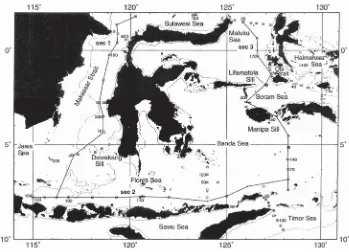
par-Figure 2. Stations of CTD
(conductivity-tempera-ture-depth) casts during the 1993–1994 Arlindo
Expedition as described in Ilahude and Gordon (1996). Data from Stations 1 to 103 were obtained during the southeast monsoon 1993, and that from 104 to 209 during the southwest monsoon 1994. Th e 209 stations covered by the Arlindo
Expeditionare only a fraction of the total 2608
Oceanography
Vol. 18, No. 4, Dec. 2005 48ticularly along ITF pathways (such as in the Lombok Strait)? Do internal waves have signifi cant effect on the variability of ITF?
4. Modeling: How do you incorporate
physical, chemical, geophysical, and biological aspects into a model to study the Indonesian seas? How can this model be improved to be more effi cient in method and in computer time?
5. Hydrographic conditions: How do
Pacifi c thermal conditions affect the intensity of the East Asian monsoon? How are oceanic temperature and salinity variability related to El Niño and the Indian Ocean Dipole Mode?
6. Climate change: How are the ITF
pathways linked to the desiccation in East Africa? How does the ITF af-fect monsoon variability? Does the increase in CO2 concentration of the atmosphere have a signifi cant effect on the fi shery productivity of the In-donesian seas?
7. Fisheries: How signifi cant is the
con-tribution of physical processes in the Indonesian seas to fi shery productiv-ity of the region? What is the mag-nitude of contribution of upwelling processes to the nourishment of the upper layer in the Indonesian waters? Do internal waves have a similar con-tribution as upwelling?
C LO S I N G R E M A R K S
The increasing quantity and range of studies on the oceanographic aspects of the Indonesian and adjacent waters in
recent decades is leading to a quickening pace of understanding. This is due to a number of factors, including the rapid development of technology (computers, measuring gauges, satellites), commu-nication (for exchange of information), growing interest from the oceanographic community (Indonesian and their for-eign counterparts), and support from the Indonesian government for its assis-tance with and openness to international scientifi c collaboration.
Once the magnitude and variations of the ITF are quantifi ed more accurate-ly, modeling will become an increasingly important tool in understanding the dynamics and variation of the Indo-nesian waters, and its infl uence on the adjacent waters and on the larger-scale ocean and climate system. More detailed studies of part of the Indonesian seas have already begun in the opening years of the 21st century.
A C K N O W L E D G E M E N T S
We gratefully acknowledge Drs. Arnold Gordon and Ellen Kappel for their con-structive comments, which greatly im-proved this article. We also wish to thank the reviewers for their valuable inputs on the draft. Our appreciation goes to Drs. Anugerah Nontji, M. Kasim Moosa, and Mr. Suyatno Birowo for the useful dis-cussions in the initial stage.
R E F E R E N C E S
Berlage, H.P. 1927. Monsoon current in the Java Sea and its entrances. Verhandelingen
Magne-tisch en Meteorologisch Observatorium. Batavia,
Indonesia, 28 pp.
Birowo, S., and A.G. Ilahude. 1977. On the up-welling of the Eastern Indonesian Waters. Paper presented at the 13thPacifi c Science
Con-gress, Vancouver, Canada. Published by the
Indonesian Institute of Science (LIPI), Jakarta.
Braak, C. 1921. Het Klimaat van Nederlandsch Indie. Verhandelingen Magnetisch en
Meteo-rologisch Observatorium Vol. 8. Batavia,
Indo-nesia.
Cresswell, G., and N. Wells, eds.1998. The ASEAN–Australia Regional Ocean Dynamic Experiment Expedition 1993–1995. In: Pro-ceeding of Symposium held in Lombok,
Indone-sia June 1995. Amsat Ltd., Canberra.
Delsman, H.C. 1929. The study of pelagic fi sh eggs. Fourth Pacifi c Science Congress,
Batavia-Bandoeng (Java), May-June 1929.
Fieux, M., C. Andrie, P. Delecluse, A.G. Ilahude, A. Kartavtseff, F. Mantisi, R. Molcard, and J.C. Swallow. 1994. Measurements within the Pa-cifi c-Indian Oceans throughfl ow region.
Deep-Sea Research 41(7):1,091–1,130.
Fieux, M., R. Molcard, and A.G. Ilahude. 1996. Geostrophic transport of the Pacifi c-Indian Oceans throughfl ow. Journal of Geophysical
Research 101(C5):12,421–12,432.
Gordon, A.L. 2001. Inter-ocean exchange. Pp. 303–314 in Ocean Circulation and Climate, G. Siedler, J. Church, and J. Gould. Academic Press.
Gordon, A.L., and R. Fine. 1996. Pathways of wa-ter between the Pacifi c and Indian oceans in the Indonesian seas. Nature 379:146–149. Gordon, A.L., R.D. Susanto, and A.L. Ffi eld. 1996.
Throughfl ow within Makassar Strait. Geophys-ical Research Letters 26:3,325–3,328.
Hardenberg, J.D.F. 1952. Report of works carried out since 1939 in the Java Sea by the Labo-ratory for Investigation of the Sea, Batavia.
Proceedings, The 7th Pacifi c Science Congress 3:190–192.
Hardenberg, J.D.F., and Rd. E. Soeriaatmadja. 1956. Monthly mean salinities in the Indone-sian Archipelago and adjacent waters, for the months March 1950–February 1953. Bulletin Organization Scientifi c Research (Indonesia) Vol. 21.
Ilahude, A.G. 1964. Laporan Ekspedisi Ilmiah
Laut “Operasi Baruna” (Report of the Marine
Scientifi c Expedition “Operation Baruna”). Section: Oceanography. KOTI, Department of Defense, 143 pp.
Ilahude, A.G. 1970a. Operasi Baruna III Perairan
Laut Banda Maret-April 1970 (Operation
Baruna III Banda Sea Region March-April 1970). Section: Oceanography. Indonesian Naval Hydrographyc Offi ce (HIDRAL). Ilahude, A.G. 1970b. Laporan tentang hasil-hasil
oseanografi s Operasi Baruna III di Laut Banda
Ma-jalah Ilmiah Angkatan Laut 22:4–10, 18 charts. Ilahude, A.G. 1970c. On the occurrence of the
upwelling in the Southern Makassar Strait.
Marine Research in Indonesia 10:3–53.
Ilahude, A.G. 1975. Seasonal feature of the hy-drology of the Bali Strait. Marine Research in
Indonesia 15:37–73.
Ilahude, A.G. 1978. On the factors affecting the productivity of the Southern Makassar Strait.
Marine Research in Indonesia 21:81–107.
Ilahude, A.G. 1992. Note on the surface current system south of Jawa-Sumbawa. Pp. 31–48 in
Proceedings Third ORI-LIPI Seminar on South-east Marine Science: Oceanography for Fisher-ies,T. Sugimoto, K. Romimohtarto, S. Su-modihardjo, and H. Tanaka, eds. Tokyo, Japan. Ilahude, A.G. 1998. Three and a half decades of
oceanographical surveys in the Indonesian Waters (1960–1995). In: The ASEAN-Aus-tralia Regional Ocean Dynamics Expeditions 1993–95. Proceedings of a Symposium held in Lombok Indonesia in June 1995, G. Cresswell and G.Wells, eds. 1998. AMSAT Ltd, Canberra, Australia.
Ilahude, A.G., and Ermaitis. 1992. Sifat
permusi-man hidrologi Selat Sunda (Seasonal feature
of the hydrology of the Sunda Strait). Pp. 380–387 in Prosiding Seminar Ekologi Laut dan
Pesisir, P3O-LIPI and ISOI, H.P Burhanuddin,
E. Hutagalung, Rochyatun, and M.H. Azkab, eds. Jakarta.
Ilahude, A.G., and A.L. Gordon. 1996. Thermo-cline stratifi cation within the Indonesian Seas.
Journal of Geophysical Research 101:12,401–
12,409.
Ilahude, A.G., P.D. Komar, and Mardanis. 1990. On the hydrology and its relation to the pro-ductivity of the Arafura Sea. Netherland
Jour-nal of Sea Research 25(4):573–583.
Kuenen, P.H. 1935. Geological interpretation of the bathymetrical results. In: The Snellius Ex-pedition in the Eastern Part of the Netherlands
East Indies 1929-1930. 5(1):62–69.
Menzies, G. 2003. 1421: The Year China
Discov-ered America. HarperCollins, New York, NY,
552 pp.
Molcard, R., M. Fieux, J.C. Swallow, A.G. Ilahude, and J. Banjarnahor. 1994. Low frequency vari-ability of the currents in Indonesian channels (Sawu-Roti and Roti-Ashmore Reef).
Deep-Sea Research 41(11/12):1,643–1,661.
Molcard, R., M. Fieux, and A.G. Ilahude. 1996. The Indo-Pacifi c throughfl ow in Timor Passage. Journal of Geophysical Research
101(C5):12,411–12,420.
Nontji, A. 2005. Laut Nusantara. 4th ed. Jambatan,
Jakarta, 356 pp.
Nontji, A., and A.G. Ilahude. 1975. Ekologi Fito-plankton Selat Bali (PhytoFito-plankton ecology of the Bali Strait). Oseanologi di Indonesia
5:25–42.
Pariwono, J.I. 1986. Wind Stress, Mean Sea Level and Inter-Ocean Transport in the Australasian Region. Ph.D. Thesis. School of Earth Science, Flinders University, South Australia.
Rahardjo, G., and A.G. Ilahude. 1965. Tempera-ture and salinity observation in the Java Sea.
Baruna Expedition I(1):77–102.
Robertson, J.B., and J. Spruyt. 1967. A History of
Indonesia. MacMillan, Melbourne, Australia,
258 pp.
Schott, G. 1935. Geographie des Indischen und
Stil-len Ozeans. C. Boysen Buchhandlung,
Ham-burg, Germany, 413 pp.
Soegiarto, A., and J.H. Stel. 1998. The Indonesian experience in marine capacity building.
Ma-rine Policy 22(3):255–267.
Soeriaatmadja, R., 1956. Seasonal fl uctuations in the surface salinity off the coast of Java. Ma-rine Research in Indonesia (1): 1-19. Soeriaatmadja, R.E. 1957. The coastal current
south of Java. Marine Research in Indonesia
3:41–55.
Susanto, R.D., and A.L. Gordon. 2005. Velocity and transport of the Makassar Strait through-fl ow. Journal of Geophysical Research 110: C01005, doi:10.1029/2004JC002425. Tydeman, G.F. 1903. Hydrographic results of the
Siboga expedition. SibogaExpedition
Mono-graph III, E.J. Brill, Leiden, The Netherlands, 78 pp.
Van Bosse, A.W. 1928. Rhodophycae, Gigartinales et Rhodominales. Liste des Algues du Siboga Expedition. Siboga Expedition Monograph
59d:1–41.
Van der Stok, J.P. 1922. De Zeen van Nederlandsch Oost Indie. E.J. Brill, Leiden, The Netherlands. van Riel, P.M. 1932. The Snellius Expedition.
Conseil Perm. Internat. p. l’Explor. De la Mer.
Journal du Conseil 7:212–217.
van Riel, P.M. 1934. The bottom confi guration in relation to the fl ow of the bottom water. The
Snellius Expedition in the Eastern Part of the
Netherlands East Indies 1929-1930, Vol II, Part
2, Chapter II. E.J. Brill, Leiden, The Nether-lands, 63 pp.
van Riel, P.M. 1938. Infl uence of Bottom Confi gu-ration on Properties of Sea Water in Abyssal
Layers. Congress International D. Geographie,
Amsterdam.
Veen, P.C. 1953. Preliminary charts of the mean surface salinity of the Indonesian Archipelago
and adjacent waters. Bulletin Organization Scientifi c Research in Indonesia 17:1–47. Weber, M., and L.F. de Beaufort. 1911. The Fishes
of the Indo-Australian Archipelago I: Index of the Ichthyological Papers of Bleeker. E.J. Brill Ltd., Leiden, 409 pp.
Weber, M., and L.F. de Beaufort. 1913. The Fishes of the Indo-Australian Archipelago II: Mala-copterygii, Myctophoidea, Ostariophysi: I Si-luroidea, with 151 illustrations. E.J. Brill Ltd., Leiden, 404 pp.
Weber, M., and L.F. de Beaufort. 1916. The Fishes of the Indo-Australian Archipelago III:
Ostario-physi: II Cyprinodea, Apodes, Synbranchii, with
214 illustrations. E.J. Brill Ltd., Leiden, 455 pp. Weber, M., and L.F. de Beaufort. 1922. The Fishes
of the Indo-Australian Archipelago IV: Het-eromi, Solenichthys, Synentognathi, Percesoces, Labirinthici, Microcyprini, with 103 illustra-tions. E.J. Brill Ltd., Leiden, 410 pp.
Weber, M., and L.F. de Beaufort. 1929. The Fishes of the Indo-Australian Archipelago V: Anacan-thini, Allotriognathi, Heterosomata, Berycomor-phi, Percomorphi; Families: Kuhliidae, Apogoni-dae, PlesiopiApogoni-dae, PseudoplesiopiApogoni-dae, Priacanthi-dae, Centropomidae, with 98 illustrations. E.J. Brill Ltd., Leiden, 458 pp.
Weber, M., and L.F. de Beaufort. 1931. The Fishes of the Indo-Australian Archipelago VI Per-ciformes (Continued) Families: Serranidae, Theraponidae, Sillaginidae, Emmelichthyidae, Bathyclupeidae, Coryphaenidae, Carangidae, Rachycentridae, Potamomidae, Lactariidae,
Menidae, Laeiognathidae, Mullidae, with 81
il-lustrations. E.J. Brill Ltd., Leiden, 448 pp. Wyrtki, K. 1957. Die Zirkulation an der Oberfl
a-che der sudostasiatisa-chen Gewasser. Deuztsche
Hydrographie Zeitung 10(1):1–13.
Wyrtki, K. 1958. The water exchange between the Pacifi c and the Indian Oceans in relation to upwelling processes. Proceedings of the Ninth Pacifi c Science Congress 16:61–66.
Wyrtki, K.1961. Physical Oceanography of the Southeast Asian Waters. Naga Report 2, Scripps Institution of Oceanography, La Jolla, CA, 195 pp.
Wyrtki, K. 1971. Oceanographic Atlas of the
In-ternational Indian Ocean Expedition. U.S.
Na-tional Science Foundation, Washington, D.C., 571 pp.
Zaneveld, J.S. 1950. A review of three centuries of phycological work and collections in Indo-nesia (1650–1950). Organization of Scientifi c