SMART AIRPORT FOR NOISE REDUCTION
CASE STUDI AND APPLICATION TO
SOEKARNO-HATTA INTERNATIONAL AIRPORT
Nurdini Rospitha Tambunan
1, Isam Shahrour
2Abstract
Actualize the future airport as an aerotropolis and meet sustainable criteria not only for improving the needs of a good quality and safety transportation, but also minimize the environmental impact of airport activities. Noise pollution as one of this impact always becomes the most important issue to solve around the urban area in the vicinity of aerodrome.
Defining the exposed area by nuisance needs aircraft’s noise modelling which will produce the noise map zone with
software such as Integrated Noise Modelling required input of airport’s infrastructure, traffics, trajectories, weather
report, and topography surround the aerodrome. The map produced will be an effort for implementing Smart noise
solution as one best solution to protect the community from the impact of aircraft’s noise. The implementation of one
integrated system of smart noise measurement and monitoring such as Sentinelle and VITRAIL (VIsualisation des Trajectoires et des Informations en Ligne) in France has been studied in this report in order to learn about how its work and implement them in the future airport.
Keywords : Sustainability, Smart Airport, Aircraft’s Noise, Noise Monitoring and Measurement System
1
Student at Université Lille 1 & Universitas Indonesia, e-mail address: [email protected]
2
Director of Laboratoire Génie Civil et géo-Environnement (LGCgE), Nord Pas de Calais, France
1.
Introduction
At present, many airports quiet find a way to have a direct and efficient connectivity between them and the city. Which mean they still stand with the concept that the city or urban area must be putted away from the
airport’s area. Nonetheless, the idea of building urban
area far from the airport has gave us problem to be solved. One of the problems is about transportation to and from the airport. Starting this point of view, the concept of aerotropolis has become an answer of the questions of one city airport which provide all the needs of the community. In other words, the airport expansion and urban development will congeniality step forward without any complication.
Hereinafter, we are facing problems for developing future or smart airport. The intention of developing a new design of smart airport will definitely increase the traffic growth. The subsequent effect from the traffic enhancement will obviously create another possibility of environmental impacts. There are three main of environmental impacts which related to the airport in
the future, global impacts, local impacts and uneven impacts (Eurocontrol, 2013).
Starting from these results, we have found that the major delinquent factor effecting urban development in the vicinity of the airport is noise pollution. Furthermore, Soekarno-Hatta International Airport is facing the same noise problem with the aircraft traffic growth 11,8% per year and movement 72 per hour in 2014 (www.indonesia-investment.com).
2.
Methodology
The question of this research is how to define the noise pollution in the urban area at the airport environment with the smart noise solution. It would be carried out by focusing on literature research in comparison between method of noise measurement and monitoring in three airports in France which are Toulouse Blagnac airport, Marseille Provence Airport, and Paris Orly Airport.
The method is following ICAO (Internatiional Civil Aviation Organization) document 9911 and document 29 ECAC (European Civil Aviation Conference) which is adopted by France into one technique guidance:
Élaboration des cartes de bruit autour des aerodromes
(February 2014).
We have to produce noise map which require :
1. A method for noise calculation implemented in a computer program. Commonly, France government use Integrated Noise Model and ArcGIS.
2. A database of aircraft needed to finely characterize noise emissions of each aircraft.
3. Data on infrastructure, traffic, trajectories and operating conditions for each aerodrome.
As for performing the aircraft noise modelling, the collection and processing some of necessary data required. The data needed are Airport infrastructure; traffics; trajectories and flight profiles; meteorological condition and topography in each aerodrome.
These factors are affecting the travel of noise in to the urban area. And from this point of view, the aircraft’s noise modeler could create the noise maps to make a visualization of noise exposure on the land.
The visualization by the maps will give an authority a best chance to produce and build regulations to protect the community from the noise pollution and also to define smart noise systems which could generate a better solution for noise in a sustainable way.
2.1 Method of Noise Measurement and
Monitoring
at
Toulouse
Blagnac
Airport
Toulouse Blagnac situated in south west of France, at the heart of the Midi-Pyrénées region, about twenty minutes from Toulouse city center. Runway dimension 3000 x 45 m and 3500 x 45 m with orientation to 320 North and 140 south. Traffic statistic in 2013 is 95.650 aircraft movement.
Area exposed by noise pollution defined by producing the noise map then considering the topography in Blagnac and residence area which have affected most,
the authority preferred to implement Sentinelle a system of noise measurement since September 2002.
Sentinelle with 6 stations fixed and mobile measurement operates a system of noise measurement and visualization of the trajectories of aircraft operating 24h/24. It could records all ambient noise and automatically detects the passage of aircrafts. The other advantage of Sentinelle is, it could respond to any request factual information or complaint regarding an event that caused nuisance.
The system will be provided by the data from the station of noise measurement, trajectories of aircrafts from radar, weather report from Meteo France, flight identification from CCIT (Chambre de Commerce et
d’Industrie) and also information and complaints from
the airport neighborhood.
2.2 Method of Noise Measurement and
Monitoring at Marseille Provence
Airport
Marseille Provence airport located 27 km (17 miles) northwest of Marseille, on the territory of Marignane, both communes of the Bouches-du-Rhône département
in the Provence-Alpes-Côte d'Azur région of France. Runway dimension 3500 x 45 m and 2370 x 45 m with orientation to 320 North and 140 south. Traffic statistic in 2013 is 117.955 aircraft movement.
Considering topography and urban area in noise map zone, the airport stakeholder providing Marseille Provence with a network of monitoring noise station around Marseille Provence to monitor the daily noise and aircraft trajectories since September 2004. This system which has set up by Brüel and Kjaer Company allows people to view, analyze and record the trajectories of all aircraft and noise level associated with their passage through an area of about 40 km from the airport.
It consist of a host which collects all data from noise sensors, weather report from Meteo France, and from radar at the control tower at the airport, which will regularly communicate the position and trajectory of the aircraft after take-off and landing phase. Furthermore, it will analyze the tracks of the aircrafts, level of noise, and manage the complaints from the community.
2.3 Method of Noise Measurement and
Monitoring at Paris Orly Airport
3650 x 45 m with orientation 070 north and 250 south. Traffic statistic in 2013 is 233.497 aircraft movement.
Hereinafter the method of measurement and monitoring of noise pollution in Paris Orly is integrated in one system called VITRAIL (VIsualisation des Trajectoires et des Informations en Ligne). VITRAIL is software that allows people to view on the internet trajectories takeoff and landing aircraft from the Paris airports. It is an indispensable tool for us because it allows us to spot, then terminate the call of hardcore trajectory deviations (mainly takeoff facing east).
The system allows interested persons, including the coastal airports, see the trajectories of aircraft overflying the region Paris. The information sought will be displayed on a display screen on a background map of the "road map" type the path of a device indicating its type and altitude, as well as the noise level associated with the track. VITRAIL gives a representation of air traffic in Ile-de-France and noise measurements associated in near real time (time delayed 30 minutes). Accessibility constantly this information allows us to be much more effective in identifying and reporting deviations trajectory characterized.
2.4 Noise Exposure Measurement
All the system implemented in Toulouse Blagnac,
Marseille Provence and Paris Orly, need the neat calculation to define the area which we should put on it the noise monitoring station. The reason is because every airport has their own characteristics and located in different topography, and also has different type of runway configurations and traffics capacity.
All those reasons are effecting in noise propagation which could have several impacts to the community in the vicinity of the aerodrome. Hereinafter, the screening of urban area around the airport and what level of noise are exposed on that area would be necessary, and the knowledge about noise propagation which related to topography will be useful to determine the location of
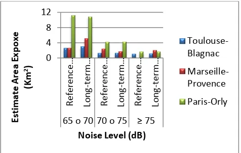
Figure 1. Comparison Estimate Area Exposed by Noise Level at 55-65 dB Between 3 Airport.
Figure 2. Comparison Estimate Area Exposed by Noise Level at 65-75 dB Between 3 Airport.
However topography is not the only factor which
The profile of aircrafts entering each airport depends on the runway capacity and demands per year. Nevertheless, we are not in discussion about the
passenger’s demands as of the result of this analysis
only from the point of how much level of noise which could produce by the aircraft in each event. As well as the profile of aircrafts and the calculation of each events not involved in here.
Here is the list of mostly aircrafts in Paris Orly:
Caravelle, Cessna citation Mustang, Mooney Acclaim Type S, Douglas DC-8, Sukhoi Superjet 100, Helicopter Dynali H2S, Gulfstream G550, Canadair CL 415, Global 6000, Daher-Socata TBM850, Daher-Socata TBM900, Schempo-Hirth Duo Discus, Boeing 787 Dreamliner, Boeing 747 Dreamlifter, Boeing 747-800
Intercontinental, Alpha jet, Patrouille de France, Airbus A380, A380, Parangon écolo, Airbus A400M, Embraer Legacy 650, Eurocopter EC 225, Eurocopter Mercedes-Benz, New version of EC145.
(Source:http://www.entrevoisins.org/aerien/avions/50_fi ches_avion/default.aspx)
Furthermore, the knowledge about the facts above are already enough to give us information that determining and predicting the area expose by noise pollution in the future will base on this criteria.
3.
Result and Implementation
Smart noise solution recommended by ACNUSA (Autorité de contrôle des nuisances aéroportuaires) is already implemented in majority of airports in France in conjunction with the regulations which support the habitants who have a probability in exposed by nuisance of aviation or either already exposed. No other way that this concept should be adopted and implemented in order to aid the habitants in vicinity of the airport corresponding with the explanation above.
Jakarta Soekarno-Hatta (Soetta) airport is the main airport situated in Cengkareng, about 30 km from the centre of Jakarta city, the capital city of Indonesia. It has 2 runways parallel 07L/25R (3.600 x 60 m) and 07R/25L (3.660 x 60 m) with daily traffic average 1200 movements. The airport handled more than 43 million passengers and 338,711 aircraft movements in 2010.
The variety of aircraft’s type in Soetta is more or less
the same as those in 3 airports in France. However, the noise management in Soetta is still in progress and the community around Soetta airport still exposed by nuisance until now.
Refer to the research on capacity evaluation of environmental noise in Soetta by Kusnoputranto. et, al., (2014) have showed that the average noise level is 69.08 dB(A), as of inhabitants live near Soetta are highly risk in expose of noise disturbance. Based on the result, Soetta needs a system which could answer the noise management problem, in other word it needs smart noise solution.
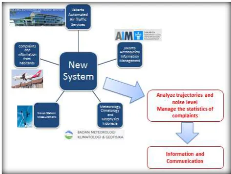
Adopting method of noise measurement and monitoring in France, we propose the new system which would be possible to implement in Soetta. This system will provide information to the public, especially to the policy holder to be able to take the actions necessary to protect the community from noise pollution.
The picture below will illustrate how this system will work. Information required by the system to build the noise zone map will be provided from:
1. Jakarta Automated Air Traffic Services (JAATS). Information given are the real trajectories of flight, history of flight, number of movements.
2. Jakarta Aeronautical Information Management (AIM). It gives information of next traffics, type of aircrafts, schedule, etc.
3. Meteorology, Climatology and Geophysics Indonesia (BMKG)
4. Complaints and information from habitants. 5. Noise Measurement and monitoring station.
Figure 3. Smart Noise Solution Concept for Jakarta Soekarno-Hatta
All information processed in this system will be used to detect areas that are exposed to noise pollution in a high level. Hereinafter, analyze the trajectories of the aircrafts which fly over the Soetta area. The analysis must also have input from the amount of the complaints from the community of the airport.
Furthermore, the analysis result would be useful to give information to all stakeholders and provide them future steps to communicate about noise management in airport neighborhood.
4.
Conclusion
The present-day airport development leads to aerotropolis or city airport. This definition brings us to environmental problem which will occur in the urban development around the airport.
Noise pollution is already became one of environmental problem which needs smart solution because of its
impact to the human’s health in the vicinity of aerodrome. Moreover aircraft’s noise is the main source
of noise pollution to be counter in order to minimize future impacts in urban area near the airport.
guide the member of ICAO to provide steps in protecting human from pollution caused by the airport activities. In noise case, there are managements in reduction of noise at source; land-use planning; noise abatement operational procedures; operating restrictions; and noise charges.
However, the regulation must base on the fact about the noise at the airport. Hereinafter, we need to figure out about the aircrafts noise modelling to define the noise zone around the airport using some software such as Integrated Noise Modelling, ANCON or FLULA program. Furthermore the noise zone produced by this program implemented in proposing action in the future. France authority has adopted document 9911 ICAO and document 29 ECAC to develop one system in noise measurement and monitoring in the airports. This system include the method for noise calculation implemented in a computer program, a database of aircraft to figure out the noise emissions of each aircraft, and data on infrastructure, traffic, meteorology, trajectories and operating for each aerodrome.
Airports which are already implemented this system are Toulouse Blagnac, Marseille Provence, and Paris Orly. Toulouse Blagnac adopted Sentinell, Marseille Provence implemented a system similar with Sentinelle, and Paris Orly has running VITRAIL to give better information about noise pollution to the community. However, the topography surround the airport is also one of the factors which is affecting the noise
propagation. The comparison of airport’s contour area
between Toulouse Blagnac, Marseille Provence and Paris Orly pointed that the more flat the contour, the less noise propagated more. This factor could be the one to consider in locating the station of noise measurement and monitoring.
Implementation of Smart noise solution in Jakarta Soekarno-Hatta International Airport would be considered in the same method as in three airports which have been studied. We need collection of data to produce noise map zone, then the noise measurement area at the vicinity of Soekarno-Hatta airport.
Acknowledgment
This work was under internship program supported by the Laboratoire Génie Civil et géo-Environnement in Lille. A special acknowledgement goes to Prof. Isam Shahrour for helpful suggestions in order to improve
this paper and also to Ministry of Transport of Indonesia
for funding author’s master degree program. The author
would like to express gratitude also to Prof. Dr. Ir. Irwan Katili, DEA and Mohammed Ali Berawi, M. Eng. Sc., Ph.D for their support during the author study period in Indonesia.
References
Network Manager nominated by European Commission.
“Challenges of Growth 2013, Task 4: European Air Traffic in 2035” Eurocontrol. 2013.
ICAO. Review of Noise abatement procedure research & development and implementation results: Discussion of survey results. 2007.
ECAC.Report on standard method of computing noise contours around civil airports. Vol.1:Applications guide. Technical report Doc.29. European Civil Aviation Conference. December 2005.
Zaporozhets O.I, Tokarev V.I. Aircraft Noise Modelling for Environmental Assessment Around Airports. Acoustic Laboratory, Kyiv International University of Civil Aviation, Ukraine. 1998.
Filippone A. Aircraft noise prediction. Progress in Aerospace Sciences (2014), http://dx.doi.org/10.1016/j.paerosci.2014.02.001i www.indonesia-investment.com
Ministére de l’Écologie, du Développement durable et
de l’énergie, Direction general de l’Aviation civile, Service technique de l’Aviation civile.”Élaboration des cartes de bruit autour des aerodromes” Guide
technique. February 2014
.
dgac.DSAC.”Plan de Prévention du Bruit dans
l’Environnement de l’aérodrome de Toulouse
-Blagnac 2012-2017”.12 March 2013.
Cinq sur cinq, Lettre aux riverains de l’aeroport
Tpoulouse-Blagnac. Sentinelle: Priorité à la
surveillance et à l’information. December 2002.
Direction Marketing aéroport Toulouse Blagnac. Bulletin Statistique Environnement Année 2013.
Dgac, DSNA. “Paris Orly Configuration Ouest”. 2013.
Kusnoputranto H, Budhi Soesilo TE, Kristanto GA, Sardjono W. apacity Evaluation of Environmental Noise for Airport Sustainability through
Eco-Airport”.
www.theinternationaljournal.or>RJSITM: Volume:03, Number: 3, January 2014.
DGAC. Direction du transport aérien.Traffiv Aéroportuaire 1986-2012. June 2013.
http://www.entrevoisins.org/aerien/avions/50_fiches_av ion/default.aspx
http://www.indonesia-investment.com http://www.developpement-durable.gouv.fr http://www.acnusa.fr
www.toulouse.aeroport.fr www.marseille.aeroport.fr http://www.avevy.com/vitrail.htm
http://www.aeroport.fr/les-aeroports-de-l-uaf/stats-paris-orly.php
http://www.toulouse.aeroport.fr/en/node/1679 http://fr-fr.topographic-map.com/