PROBE VEHICLE TRACK-MATCHING ALGORITHM BASED ON SPATIAL
SEMANTIC FEATURES
Y. Luo a, b, X. Song b, L. Zheng c, *, C. Yang d, M. Yu d, M. Sun c
a
School of Resource and Environmental Sciences, Wuhan University, China - [email protected] b
Wuhan KOTEI Infomatics Co., Ltd. China - (yuejunl, xiangbos)@kotei-info.com c
School of Geodesy and Geomatics, Wuhan University, China – [email protected], [email protected] d
Department of Geography and GeoInformation Sciences, College of Science, George Mason University, Fairfax, VA 22030 USA – (cyang3, myu7)@gmu.edu
KEY WORDS: Spatial Semantic Features, Probe Vehicle Path, Spatial Data Mining, Global Matching Model, Track
ABSTRACT:
The matching of GPS received locations to roads is challenging. Traditional matching method is based on the position of the GPS receiver, the vehicle position and vehicle behavior near the receiving time. However, for probe vehicle trajectories, the sampling interval is too sparse and there is a poor correlation between adjacent sampling points, so it cannot partition the GPS noise through the historical positions. For the data mining of probe vehicle tracks based on spatial semantics, the matching is learned from the traditional electronic navigation map matching, and it is proposed that the probe vehicle track matching algorithm is based on spatial semantic features. Experimental results show that the proposed global-path matching method gets a good matching results, and restores the true path through the probe vehicle track.
* Corresponding author
1. INTRODUCTION
With the rapid development of urbanization and society, vehicles have played a significant role in human life, and yet caused various problems to environment and economy. As a new-generation advanced navigation data acquisition mode, probe vehicle technology provides more possibilities to solve the above series of problems. Probe vehicle, called GPS probe car, is used in Intelligent Transport System (ITS) to obtain the urban road traffic state as the effective way in recent years (Geng, 2013).
Probe vehicle is an advanced road traffic information collection technology in ITS field in the current internation (Hao, 2012). The data range of probe vehicle technology can be distributed in all areas and collect data for 24 hours. Using wireless real-time transmission, centralized processing can greatly improve the efficiency of information acquisition. At the same time, the use of existing resources of GPS and communication network make the acquisition equipment maintenance and installation costs lower (Zhu, 2009). Therefore, the probe vehicle technology is more economical and efficient method. Since point-by-point, nearest road matching often fails, researchers have developed methods that match several points at once. Kim and Kim (Krumm, 2008) look at a way to measure how much each GPS point belongs to any given road, taking into account its distance from the road, the shape of the road segment, and the continuity of the path. The measure is used in a fuzzy matching scheme with learned parameters to optimize performance. Brakatsoulas et al. (Brakatsoulas, et al., 2005) uses variations of the Fréchet distance to match the curve of the GPS trace to candidate paths in the road network. They tested their algorithms on 45 routes in Athens, Greece. Alt et al. (Alt, et al. 2003) give a generalization of the Fréchet for matching curves. Hidden Markov Models (HMM) solve this problem by explicitly modeling the connectivity of the roads and considering many different path hypotheses simultaneously.
To take advantage of probe vehicle technology in spatial data mining, it needs accurately reconstruct the real path that probe vehicle track through, and achieve the spatial registration of floating vehicle trajectory data and the real road network data. The probe vehicle trajectories data has some data characteristics such as large sample interval and position noise, which makes electronic map matching of the traditional method not suitable for the path matching of probe vehicle trajectories. Therefore, it is difficult to conduct the spatial data mining in probe vehicle trajectories. We will compare and contrast this work with ours subsequently after we explain the details of our algorithm.
2. PROBLEMS IN TRADITIONAL PATH MATCHING
ALGORITHM
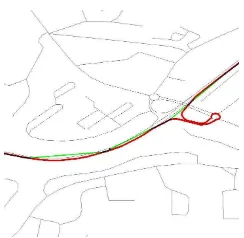
conventional way. If it is still used the traditional matching method of navigation map, it may lead to the wrong path, and even the whole trajectory which match up with a passable path(as shown in Figure 1). Obviously, the traditional navigation map matching algorithm cannot be directly applied to the probe vehicle system (Wang, 2012).( Black is the map of the road network, the green line for probe vehicle trajectories, red for trajectory matching results).
Figure 1 Probe vehicle and its true path and road network
3. GLOBAL MATCHING MODEL BASED ON SPATIAL
SEMANTIC FEATURE
Matching problem model of traditional navigation map make a match only according to the position of the GPS receiver, the vehicle position and vehicle behavior near the time. Compared with the entire route, it is a local path matching. For probe vehicle trajectories, the sampling interval is too large and there is a poor correlation between adjacent sampling points, so it literature (Sinn, 2001) proposed method of trajectory point fuzzy matching. To a certain extent, it can reduce the influence of noise, but still select in the local optimal path.
From the perspective of information fusion (Sotirls, 2005), For offline maps match like probe vehicle track matching (Pereiraf, 2009), it can also examine the position information of all the sampling points on the track. Between these different sampling points, there can be some behavior such as access, limited access time. Therefore, it can be considered the overall trajectory of probe vehicle, and make the optimal trajectory of global matching.
Based on the above analysis, it proposes the following float trajectory path matching method based on spatial semantic features.
1) Each track is regarded as a proof of information to restore the true path of trajectory.
2) Each trajectory point must be in the scope of the fuzzy matching in the road net.
3) According to a path way to explore, fuzzy matching results for all track points are connected in turn, then get all the possible global matching path.
4) According to the evaluation standards of some space semantic, searching a global optimal matching path in the global matching path.
Set all possible global matching path from the global matching
path model as P=
{
pt,t=1,2,!,l}
the pathp
t is madeRoad category changes of the road
p
tis(
)
4. THE SPATIAL SEMANTIC FEATURE REDUCTION
METHOD BASED ON PROBE VEHICLE TRAJECTORIES
According to the global matching model based on spatial semantic feature and selected spatial semantic feature, it is proposed float trajectory path restoration methods based on spatial semantic features.
4.1 Track point path searching
With each float trajectory point as the center, matching all the
way within a certain value (
r
0). Set the road collection get by
an fuzzy match as i
{
i i imi}
matching in two adjacent track points.For example, while searching between track point i and track
certain threshold
s
0of the road number using the Dijstra
algorithm, where
(
n
i≥
0
)
Finally, getting local path set
{
(
,
,
,
,
1,)
}
1 in i kin ij i
i
r
l
l
l
l
R
i
jk +
=
!
between track point i and
track point i+1, where
)
0
;
,
,
2
,
1
;
,
,
2
,
1
(
j
=
!
m
ik
=
!
m
i+1n
i≥
.4.2 Optimal path selection based on spatial semantic
features
For above all possible access route
R
ibetween adjacent track
points, where
(
i
=
1
,
2
,
!
,
n
)
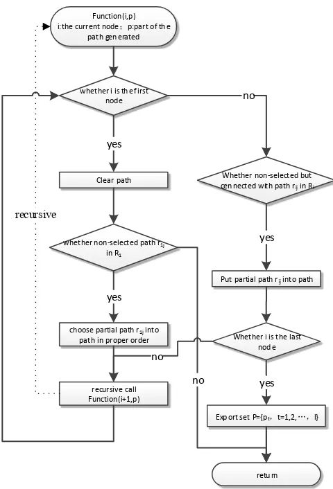
, connecting into a full path by choosing connecting path with track points as much as possible.t
p
generation algorithm flow chart is as shown in Figure 2. According to this algorithm, it can be obtained the set of all the
full path, which is
P
=
{
p
t,
t
=
1
,
2
,
!
,
l
}
. In the full path of all, selecting the optimal a full path as the route of the trajectoryby the formula, which is
( )
t l topt
p
p
ϕ
, , 2 , 1
min
!
=
=
.
ϕ
( )
p
t isthe spatial semantic characteristic function of
p
t.Function(i,p)
i:the current node;p:part o f th e
path gen erated
whether i is th e first nod e
Clear path
yes
whether n on‐selected path r1j
in R1
ch oose partial path r1j into
path in proper order
yes
retu rn
no
Whether non‐selected but cen nected with path rij in Ri
no
Put partial path rij into path
yes
Whether i is the last nod e
Exp ort set P={pt,t=1,2,…,l}
yes
recursive call Function(i+1,p)
no
recursive
Figure 2 The flow chart of the global full path generation
5. EXPERIMENTAL VERIFICATION
By using the method in this paper, the path matching reduction experiment is completed by random sampling 300 vehicle acquisition track. In this experiment, the fuzzy matching
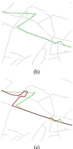
threshold r0 of track points is 50 meters, the road number threshold S0 is 15. As shown in the experimental results, there are 300 tracks matching complete route. Through visual inspection, there are 269 tracks which are restored ideally, accounting for 89.66%. Figure 3~ Figure 5 respectively means practical trajectory matching results. (Black is the map of the road network, the green line for probe vehicle trajectories, red for trajectory matching results)
(a)
(b)
(c)
Figure 3 The overall view and a partial enlarged
view by tracks1 matching
(b)
(c)
Figure 4 The overall view and a partial enlarged
view by tracks2 matching
(a)
(b)
(c)
Figure 5 The overall view and a partial enlarged
view by tracks5 matching
6. CONCLUSION
For the spatial semantic analysis problem in probe vehicle track data mining, this paper describes the main problem when the traditional navigation electronic map matching method is used for probe vehicle track map matching. And it puts forward the probe vehicle trajectories matching technology based on spatial semantic features. Through the actual data, the method presented in this paper is verified by experiment. Experiments show that matching method proposed in this paper gets a better match, and restores the real path float trajectory through. Since the method proposed in this paper requires all possible paths of the probe vehicle trajectories to make the comparison operator, so as to select the optimal path. The computation and consumption of hardware resources is too large. Thus when the probe vehicle track contains more track points, the performance of the algorithm needs further optimization.
ACKNOWLEDGMENT
The authors would like to thank the anonymous reviewers and members of the editorial team for the comments and contributions. This work is supported by Digital Cartography and Land Information Application Engineering Key Laboratory Open Research Fund of National Administratoin of Surveying, Mapping and Geoinformation and by 2014 Youth Science and Technology Chenguang Plan of Hubei Province (China) and by the National High Technology Research and Development Program of China (863 Program) No. 2013AA12A202
REFERENCES
Alt, H., et al., 2003. Matching Planar Maps. Journal of Algorithms, 49: pp. 262–283.
Brakatsoulas, S., et al., 2005. On Map-Matching Vehicle Tracking Data, in 31st International Conference on Very Large Databases (VLDB 2005).:Trondheim, Norway p. 853- 864.
Dai, X., Ferman, M., Roesser R P. 2003. A simulation evaluation of a real-time traffic information system using probe vehicles, Intelligent Transportation Systems, Proceedings. IEEE, pp:475-480.
Geng, X.,WANG, S., Ji, J., 2013. Fast Road -Matching Algorithm of Floating Car. Journal of Water Resources and Architectual Engineering, Vol11,No.1:122-125
Gou, X., Zuo, X., Zhang, Y., 2013. Application of Digital Velocity Model in Urban Traffic Dynamics Analysis Based on probe-car. Science Technology and Engineering, Vol13,No.11:3172-3177
Hao, Y., Wu, G., Zhou, S., 2012. A Multi-vehicle Speed Fusion Algorithm Based on Probe Vehicle Data. Journal of Transport Information and Safety, Vol30, No.169: 56-61.
Krumm, J., 2008. A Markov Model for Driver Turn Prediction, in Society of Automotive Engineers (SAE) World Congress. Detroit, Michigan, USA.
Li, X., Meng, Q., 2002. The Applications of GPS Technology in the Real-Time Detection of City Traffic Condition To GPS. Journal of Ocean University of Qingdao:natural science edition, 32(3): 475-481.
Information Science of Wuhan University, 34(6): 715-718.
Pereir, F., Costa, H., 2009, An off-line map-matching algorithm for incomplete map databases. European Transportation Research Review, 1(3):107—124. Schafer, R., Thiessenhusen, K., Wagner, P., 2002. A traffic
information system by means of real-time floating-car data. ITS world congress.
Sinn, K., Jong, H., Adaptive Fuzzy-Network-Based C-Measure Map-Matching Algorithm for Car Navigation System.
IEEE Transactions on Industrial Electronics, Vo1.48, No.2.
Sinn, K., Jong, K., 1999,Q-factor Map Matching Method Using Adaptive Fuzzy Network. IEEE International Fuzzy Systems Conference Proceedings. pp22-25.
Sotirls, B,. 2005, On Map-Matching Vehicle Tracking Data.
Proceeding of the 31st VLDB Conference.
Su, J., Zhou, D., Yue, C,. 2001,Real-time Map-matching Algorithm in GPS Navigation. Acta Geodaetica et Cartographica Sinica,30(3):252 256.
Tang, J., Cao, K., 2008, An Adaptive Trajectory Curves Map-matching Algorithm. Acta Geodaetica et Cartographica Sinica,37(3),pp:308 315
Wang, M., Cheng, L., 2012, Real-time Map-matching Algorithm in GPS Navigation System for Vehicles.
Acta Geodaetica et Cartographica Sinica,2 Vol41,No.1:133-138
Zhang, C., 2007, Research on the Traffic Data Collection and DataProcessing Theory and Method based on probe-car. Shanghai:Tongji University.
Zhang, Z., Lin, X., Lin, S., 2011, Traffic Parameter Features in Traffic Incidents Based on Probe-car Data. Journal of Transport Information and Safety,29(3): 94-98. Zhu, T., Guo, S., 2009,A Study on probe-car Based Information