TOPOGRAPHIC MAPPING OF PLUTO AND CHARON USING NEW HORIZONS DATA
a Lunar and Planetary Inst., 3600 Bay Area Blvd., ([email protected]), b NASA Ames Research Center, Moffett Field, CA, 94035, ([email protected]), c
Southwest Research Inst., 1050 Walnut St., Suite 300, Boulder, CO 80302, d
Dept. Earth and Planetary Sciences, Washington Univ. St. Louis, St. Louis, MO 63130, e
Dept. Environmental Sciences, University of Virginia, Charlottesville, VA 22904, Houston, TX 77058, f
Johns Hopkins University Applied Physics Laboratory, Laurel, MD 20723
Commission IV, WG IV/8
KEY WORDS: Pluto, Charon, Topographic Mapping, Spatial Databases
ABSTRACT:
New Horizons 2015 flyby of the Pluto system has resulted in high-resolution topographic maps of Pluto and Charon, the most distant objects so mapped. DEM’s over ~30% of each object were produced at 100-300 m vertical and 300-800 m spatial resolutions, in hemispheric maps and high-resolution linear mosaics. Both objects reveal more relief than was observed at Triton. The dominant 800-km wide informally named Sputnik Planum bright ice deposit on Pluto lies in a broad depression 3 km deep, flanked by dispersed mountains 3-5 km high. Impact craters reveal a wide variety of preservation states from pristine to eroded, and long fractures are several km deep with throw of 0-2 km. Topography of this magnitude suggests the icy shell of Pluto is relatively cold and rigid. Charon has global relief of at least 10 km, including ridges of 2-3 km and troughs of 3-5 km of relief. Impact craters are up to 6 km deep. Vulcan Planum consists of rolling plains and forms a topographic moat along its edge, suggesting viscous flow.
* Corresponding author
1.1 Introduction
The New Horizons spacecraft flew past the Pluto system on 14 July 2015, and provided our first view of the geology and topography of Pluto and Charon by obtaining hundreds of images, including extensive stereo, with hemispheric coverage at best resolution 0.47 km/pixel and regional coverage at resolutions down to 80 meters/pixel on Pluto (Stern et al., 2015). The best imaging covered the anti-Charon hemisphere of Pluto and the Pluto-facing hemisphere of Charon, but global context was provided by approach imaging of all longitudes at resolutions of from 35 km/pixel or better. Regions south of 38° S were in permanent darkness, though illumination by Pluto’s haze extended useful imaging several 100 km into the dark regions on the encounter hemisphere.
1.2 Cartographic and Topographic Analysis
To facilitate geologic investigation of these two bodies (Stern et al., 2015; Moore et al., 2016), imaging strategies were designed to enhance cartographic and topographic mapping products for Pluto and Charon. Cartographic control was complicated by the the high-speed encounter and imaging resolution was variable across both bodies. Selection of tie points between the approach and encounter hemispheres required selection of points at resolutions from <1 to >20 km/pixel. Nonetheless, redundant imaging enhanced bundle adjustments and resulted in stable cartographic solutions and global map products (Fig. 1).
Topographic data for Pluto/Charon come from several sources. Bundle adjustments allow for determination of local radii; stereo images allow for direct DEM production; and limb observations reveal local relief along linear traces. Stereo mapping was strictly limited to the encounter hemispheres due to the rapidly decaying resolution around the “backside” of each
sphere. Parallax in the approach images was simply insufficient to resolve topography on these bodies at these distances. Shape-from-shading compliments the stereo with pixel-scale slope measurement over areas of low-Sun.
Figure 1a. Global panchromatic mosaic of Pluto at 315 m/pixel.
Map centered on 180° longitude. Dark areas were unilluminated during the 2015 encounter. The encounter hemisphere is in map center, with approach imaging to the left starting at ~35 km/pixel resolution and increasing in quality to the west.
Stereo measurements based on the LORRI framing camera are stable and provide vertical resolutions as high as 100 m and post-spacings of <1 km, much better than were acquired for Triton, for example. Stereo measurements based on MVIC line-scanner images (Fig. 2) are equally as good but are complicated by the method of image acquisition, resulting in DEM results related to these two mapping products.
The International Archives of the Photogrammetry, Remote Sensing and Spatial Information Sciences, Volume XLI-B4, 2016 XXIII ISPRS Congress, 12–19 July 2016, Prague, Czech Republic
This contribution has been peer-reviewed.
Figure 1b. Global panchromatic mosaic of Charon at 400 m/pixel. Map centered on 0° longitude. Dark areas were unilluminated during the 2015 encounter. Notes as in Figure 1a.
Figure 2a. A high-resolution 3d anaglyph of Pluto over “bladed terrain” along Pluto’s equator. Illustrating the very high quality of stereo products over this surface. The large ridged plateaus stand ~ 2 km high. Photoclinometry reveals relief of 100-200 m across individual ridges. Scene is ~500 km across.
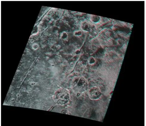
Figure 2b. A high-resolution 3d anaglyph of Pluto over cratered and fractured terrains near Pluto’s equator. The deepest canyons are ~3 km deep. Largest craters are ~45 km across.
1.3 Pluto Topography
Pluto shows astonishing topographic variability (Figs. 2 and 3), to match its geologic complexity (Moore et al., 2016). Topographci mapping is limited to the encounter hemisphere centered on 180° E and is variable in quality from ~1000 to 100 m vertical resolution. Topographic data now exist for at least some portion of each terrain that can be geologically mapped. Relief across most terrains, including high-standing bladed terrain (Fig. 3) are 2-3 km.
Figure 3. Shaded-relief map of part of Pluto, showing the relatively smooth giant depression associated with Sputnik Planum (center of image), flanked by massifs and eroded arcuate ridges. Artificial illumination is from the south (bottom).
The topography of Pluto is dominated by an ~3 km deep basin of possible impact origin (Fig. 3), corresponding to and enclosing the ~900-km diameter plain of smooth bright material, Sputnik Planum (all feature names here are informal). The polygons resembling convection cells that make up most of Sputnik Planum are barely resolved in the stereo products, and show the maximum relief of polygons as ~200 m. Photoclinometry revels relief on the order of 100 m along the margins of these cells, and 50-100 meters across the numerous small oval pits that dot the surface of Sputnik Planum. The rim of this basin has variable relief, from highly dissected arches 2-3 km above the plains to groups of rugged pyramidal to flat-topped massifs standing 2-5 km high (Fig. 3).
Impact craters display a wide range of preservation states and topography, with some craters sharply reduced in relief. Scarps and V-shaped troughs can be 3 km deep and indicate the icy crust is rigid enough to retain topography over most of Pluto’s history. A very young 150-km-wide annular plateau, Wright Mons, stands 3-4 km above the plains to the south of Sputnik Planum (Fig. 4) and is provisionally interpreted as constructional in origin. This feature stands in a walled depression several kilometres deep flanking Sputnik Planum. The International Archives of the Photogrammetry, Remote Sensing and Spatial Information Sciences, Volume XLI-B4, 2016
XXIII ISPRS Congress, 12–19 July 2016, Prague, Czech Republic
This contribution has been peer-reviewed.
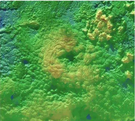
Figure 4. Color-coded topography superimposed on Pluto basemap, showing the elevated annular plateau Wright Mons. Topographic range displayed is ~4 km. Norgay Montes is the cluster of massifs to the upper right and Sputnik Planum is off image to the upper right.
1.3 Charon Topography
The topography of Charon is as varied as its geology (Moore et al., 2016. The northern portion of the encounter hemisphere is extremely rugged (Fig. 4), with craters up to 240 km in diameter and 6 km deep and reveal a polygonal network of broad troughs up to 10 km deep. A series of parallel graben and tilted blocks separate the northern terrain from much smoother plains to the south. Although intensely deformed on kilometre scales, Vulcan Planum is relatively flat and devoid of major tectonic disruptions, unlike older terrains to the north. A depressed moat ~1 km forms the outer margin of Vulcan Planum for most of its length. Convex marginal scarps, 1-2 km high, also form “moats” around isolated mountains 3-5 km high. This marginal relief suggests that the material that resurfaced the plains was a viscous fluid, perhaps an ammonia/water mixture.
Figure 5. Portion of Charon topographic map showing part of the equatorial trough and fracture system along the northern margin of Vulcan Planum, which forms the palin to the bottom of the image. The trough has relief ranging from a few 100 m to 3-4 km.
1.4 Implications
The topographic variability of both Pluto and Charon reveal geologically complex worlds and place invaluable constraints of
geologic and geophysical processes on both worlds. The relief on Pluto is pronounced and can locally exceed 5 km. This is in striking contrast to Triton where topographic amplitudes are much lower (+/- 1 km), perhaps due to much higher heat flows there related to the extremely young surface age (Schenk and Zahnle, 2007; Nimmo and Spencer, 2015). Relief of glaciated areas on Pluto can exceed 2 km locally, indicating steep local slopes. Relief across tectonic features on both bodies is comparable to that seen on other midsize icy moons, including Ariel, Tethys, and Dione. Topographic amplitude on Charon locally can exceed 10 km, which is uncommon on the inner Saturnian moons but approaching that of Iapetus, which has not undergone significant tidal or thermal heating. The preservation of significant relief on Charon, despite the evidence for widespread resurfacing, indicates that heat flow must not have been sufficient to relax the entire outer icy shell.
ACKNOWLEDGEMENTS
This work was supported by NASA’s New Horizons project.
REFERENCES
Moore, J. M. et al., 2016. The geology of Pluto and Charon through the eyes of New Horizons. Science, 351, aad7055, 1284-1293. DOI: 10.1126/science.aad7055
Nimmo F. and Spencer J.R., 2015. Powering Triton's recent geological activity by obliquity tides: Implications for Pluto geology. Icarus, 246, 2-10.
Schenk, P.M., Zahnle, K., 2007. On the negligible surface age of Triton. Icarus, 192, 135-149.
Stern, S. A., et al., 2015. The Pluto system: Initial results from its exploration by New Horizons. Science, 350, aad1815. DOI: 10.1126/science.aad1815
The International Archives of the Photogrammetry, Remote Sensing and Spatial Information Sciences, Volume XLI-B4, 2016 XXIII ISPRS Congress, 12–19 July 2016, Prague, Czech Republic
This contribution has been peer-reviewed.