Assessing sustainable land management (SLM)
Hans Hurni
∗Centre for Development and Environment, Hallerstrasse 12, 3012 Bern, Switzerland
Abstract
The term ‘sustainable development’ and its component ‘sustainable land management (SLM)’ have been receiving increas-ing attention in development co-operation and at the global level. However, practical tools which can help local users and multi-disciplinary teams to work together and apply these general concepts at the local to regional levels have emerged only very recently. Some of these tools, as well as programme support services are presented in this paper. The author argues that only a comprehensive, participatory approach involving stakeholders at all levels will have the potential to develop locally useful solutions within a favourable, i.e. ‘enabling’ institutional environment. Assessment tools will require transdisciplinary meth-ods that involve natural, social, and political sciences as well as local knowledge systems. Support services for SLM activities will have to include monitoring and impact assessment, experimentation with innovative ideas, resource assessment, infor-mation, and training. Examples from different parts of the globe have shown that the proposed tools are now receiving greater attention and may fulfil the requirements set forth by the concept of SLM. © 2000 Elsevier Science B.V. All rights reserved.
Keywords: Land degradation; Sustainable land management; Land evaluation; Sustainable development appraisal (SDA)
1. Land evaluation and sustainable land management
The objective of this paper is to review existing approaches for planning integrated land management vis-à-vis the requirements set forth by the concept of sustainable land management as it emerged from the UNCED process since the Rio conference in 1992, and to propose appropriate conceptual and methodological tools in response to these requirements.
According to Pieri (1997) there is a need to move from concepts and prescriptive approaches to an inte-grated approach to the physical planning and the so-cial and institutional dimensions of land management. Pieri argues that conflict resolution techniques are part of an integration process among different stakehold-ers, and that robust information available in a timely
∗http://www.giub.unibe.ch/cde/.
E-mail address: [email protected] (H. Hurni).
manner is often more important for the improvement of the decision-making process than comprehensive-ness. In view of these requirements, some important approaches have been developed over the past decades which can, and should, be incorporated into new, multi-level, and participatory approaches in order to allow both internal and external (more scientific) views to be expressed and discussed. Internal views in this context are defined as views derived from local knowledge and experience, while external views are based more on knowledge of a global nature, derived from scientific research and education (CDE, 1995).1
1The Centre for Development and Environment (CDE) is a
university-based institution which focuses on SLM and has been active in a number of partner countries for over 20 years, support-ing national monitorsupport-ing, research, and trainsupport-ing networks in dif-ferent African and Asian countries and specific problem settings. CDE’s primary assets are: long-term monitoring databases, par-tnership research programmes, and methodological and conceptual
84 H. Hurni / Agriculture, Ecosystems and Environment 81 (2000) 83–92
Additional explanations of these differing views are given further below.
An example of the latter type of knowledge is the methodological tool known as ‘land evaluation’, which was developed as a framework by FAO (1976) to pro-vide a scientific evaluation of land for agricultural pur-poses. The primary goal of this tool was to provide a scientific assessment of the land resources in terms of spatial distribution. More specifically, land evaluation was intended to optimise particularly the productive function of the land and to obtain other important land information at the same time. This tool was designed to be applied by a multi-disciplinary group of special-ists from the natural sciences, such as soil science, agronomy, agricultural engineering, climatology, and geomorphology.
The term ‘sustainable land management’ (SLM) emerged later (Smyth and Dumanski, 1993), as a follow-up to the global discussion on ‘sustainable development’ initiated by the Brundtland Commis-sion. Sustainable development was defined as devel-opment that “meets the needs of the present without compromising the ability of future generations to meet their own needs” (WCED, 1987). This definition was universally accepted as a common goal at the UN Con-ference on Environment and Development (UNCED) in 1992. A particularly comprehensive overview of the concept, with many inputs by individual au-thors, has been compiled and edited by Beek et al. (1997).
A framework for the evaluation of SLM was developed and propagated in the early years of the current decade (Dumanski, 1994) and will be dis-cussed in greater detail in a separate section. SLM took up most elements of land evaluation, but com-plemented them by including social, economic, and ecological dimensions. In the process, it was realised that appropriate tools are required to implement these concepts and methodologies. A major effort has been made by several agencies, including the World Bank, as well as bilateral donors and their partners, to
instruments for better planning, such as ‘sustainable development appraisal’ (SDA). CDE also concentrates on developing on-farm technologies such as soil and water conservation (WOCAT, 1997), and practical tools for participatory analysis, training and commu-nity development. These can be used in support of initiatives to promote sustainable land management and regional development.
compile such tools in the framework of impact moni-toring (Herweg et al., 1998).
The basic motivation for developing such assess-ment methods is the fact that many land use systems world-wide are characterised by a lack of sustain-ability and unsustainable trends. At the global scale, the key problems threatening natural resources and the sustainability of life support systems are: (a) soil degradation, (b) water scarcity and pollution, and (c) the loss of biodiversity (WBGU, 1996). These occur in the land use systems of virtually all socio-cultural and economic settings world-wide. However, there are great differences in the abilities of countries to cope with these key problems, and particularly with the problems of land degradation which affect all natural resources alike (Hurni et al., 1996).
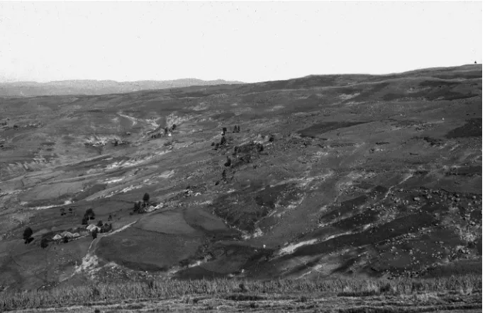
Problems of land degradation can be documented in many parts of the world to various degrees with var-ious impacts (Hurni, 1997). Some pertinent issues of land degradation are illustrated in the examples shown in Figs. 1–3, and explained in the captions. The main natural resources affected are soils, water, natural veg-etation, cultural plants, and wildlife. Perceptions of the damaging effects of these natural resource problems, however, vary greatly, between land users and other stakeholders, among these groups, and with time. From an economic perspective, for example, an envi-ronmental problem might be assessed in terms of its short-term costs and benefits, disregarding long-term social and ecological impacts. The economic viability of environmentally friendly technologies may be very different when assessed at the household and the soci-etal level. The social perspective of a community, a re-gion or a country may take account of poverty issues, social differentiation of affected groups, or societal and political effects, but disregard economic con-siderations. The ecological perspective, finally, may consider only the effects of land degradation on na-ture, i.e. wildlife, vegetation and ecological processes, disregarding both social and economic problems.
Fig. 1. Century-old soil degradation can have disastrous consequences on traditional land use systems particularly if the processes are too slow to be perceived as dangerous. An example from subsistence highland agriculture in the Simen Mountains, Ethiopia: the village area of Denkolako at 3450 m asl. Photograph by Andreas Hurni, October 1976.
2. A framework approach to sustainable land management
Sustainable land management can be defined as “a system of technologies and/or planning that aims to integrate ecological with socio-economic and political principles in the management of land for agricultural and other purposes to achieve intra- and intergener-ational equity” (Hurni et al. (1996), modified from Eswaran (1996), personal communication). SLM is thus composed of the three development components ‘technology’, ‘policy’, and in particular, ‘land use planning’ (Bouma, 1997).
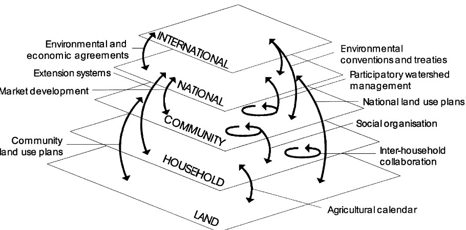
A central element of the approach proposed in this paper for the appraisal of sustainable land manage-ment (SLM) is its multi-actor perspective. In the past, most concepts and proposed technologies that were intended to further SLM related to land users as the only actor category. Examples are soil and water con-servation, land husbandry, and technologies that aim to reduce negative impacts on the land, such as salin-ity, physical impacts, or other chemical processes. In response to these one-dimensional approaches, a ‘multi-level stakeholder approach to sustainable land
management’ has been developed for finding feasible, acceptable, viable and ecologically sound solutions at the local scale (Fig. 4).
86 H. Hurni / Agriculture, Ecosystems and Environment 81 (2000) 83–92
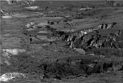
Fig. 2. Sustainable use of land and soil resources is impossible as long as immense gullies, called ‘Lavaka’, threaten rice fields with sedimentation problems: an example from Madagascar, near the village of Ambatofozy. Photograph by Hans Hurni, March 1988.
The term ‘land’ is a central element in the defini-tion of SLM. In this paper, ‘land’ refers to natural resources, such as soils, water, and living organisms, which are available in a pre-defined spatial unit (‘land units’). Particular characteristics, such as ownership, resource availability, boundary conditions, and the pol-icy and economic environments, play an important role for the assessment of ‘land use types’ and ‘land use systems’ (Bouma, 1997). ‘Sustainable’ has to be seen in all its dimensions, particularly the economic, social, institutional, political, and above all, the ecological dimension. The latter dimension forms, and will con-tinue to form, the central part of the concept (Driessen, 1997). ‘Approach’ is defined as the ways and means used to realise SLM. The main questions are: on whose behalf will SLM be realised, for what, with what means, and with what impact? ‘Stakeholders’ are in-terest groups or dependent groups, i.e. categories of people or institutions who share a common interest in a piece of land, be it an individual plot, the
terri-tory of a community, or a national conservation area. ‘Multi-level’, finally, indicates that not all stakehold-ers are farmstakehold-ers, or villagstakehold-ers, but that off-site categories such as administrators, researchers, and international organisations should be included as well. Herweg et al. (1998) give a comprehensive overview of poten-tial stakeholders who play an important role in impact monitoring for SLM. Dumanski (1997) developed par-ticular criteria and indicators for land quality assess-ment and SLM.
Fig. 3. Sustainability of land management is highly dependent on institutional frame conditions such as land ownership. Large-scale farms side by side with newly subdivided small-scale farms on the slopes of Mt. Kenya will have totally different effects on the ways and means how to realise SLM. Photograph by Hans-Peter Liniger.
88 H. Hurni / Agriculture, Ecosystems and Environment 81 (2000) 83–92
throughout the world and is represented by researchers and scientists, environment and development special-ists, politicians, and administrators, usually reflects an economic world-view and is characterised by its scientific approach. It has been called the ‘external perspective’ on natural resources. Tools for assess-ing SLM will have to include both the internal and the external perspective and find ways to reconcile differing views.
When adopting the ‘multi-level stakeholder ap-proach to SLM’, the various views and dimensions of sustainability have to be weighed against each other in a negotiated, i.e. participatory approach which does not discriminate against, or favour, particular actor categories. For example, scientific information must be coupled with indigenous knowledge to offer a better basis for decision-making in the negotia-tion processes. Experience world-wide has already demonstrated the multi-level dimensions which have to be considered to attain long-lasting solutions. The real power of this element of the approach is that it does not provide a pre-determined concept, but offers a procedure for a process of working towards devel-oping a common point of view and defining the next steps to take. The scientific approach which com-bines the internal and external knowledge systems is ‘transdisciplinary’, and goes beyond traditional interdisciplinary methodology. Science, technology, and society are the three pillars of this innovative approach, which is used for problem-solving research and in practical application.
3. Some tools for assessing and improving SLM at the local level
Obtaining locally applicable methodologies is a central concern of local stakeholders, researchers, and project planners. Aggregation of information at community to regional level will be very useful for the co-ordination of action and for providing a com-parative analysis of local areas. A specific approach has been developed for this purpose, which is called ‘sustainable development appraisal’ (SDA). SDA is a methodological tool for the participatory assessment of sustainability from local to regional planning levels (CDE, 2000). SDA is comparatively low-cost and has the potential to achieve participatory land
manage-ment solutions that conform with the SLM concept, because it includes multi-level stakeholders in the ne-gotiation process, and looks at the sustainability of the different uses of resources in large-scale area units.
SDA is preferably applied in interdisciplinary teams, in collaboration with local and external stake-holders, using a transdisciplinary approach, i.e. inte-grating both scientific and local knowledge to arrive at shared views of needs, options, and constraints in order to be able to collaborate in efforts to promote sustainable development. It includes most participa-tory learning and action methods, particularly in its local socio-economic and development components (Pretty et al., 1995). Results of an SDA will provide a synthesis of different valuations of sustainability based on visions, as well as expressed needs, nego-tiated options, and assessed constraints, for agreed action to promote sustainable development. Providing a balance between needs and possibilities is a crucial issue stressed by many authors (Muchena and van der Bliek, 1997).
The primary objective of an SDA is to provide ba-sic information and data to be used as an input into a participatory process for negotiations on the action needed to promote sustainable natural resource man-agement and development. It allows a synthetic view of the different perceptions and visions in so-called ‘development profiles’ at village, community, and regional levels, which can be used by planners, ins-titutions and decision-makers at all levels of admin-istration. Finally, it will provide baseline data and information for impact monitoring at a later stage.
The SDA methodology has thus been applied in si-tuations where external support was planned in rural settings, where problems of natural resource manage-ment were explicitly stated as problems, and where a spatial approach was chosen. SDA can be used by institutions that play an active role in rural develop-ment and natural resource managedevelop-ment. Execution of an SDA is done by multi-disciplinary teams trained in participatory learning and action and experienced in baseline studies. SDA results are used by planners and decision-makers at the policy and administrative lev-els, and provide a means which local stakeholders can use to assume accountability vis-à-vis higher levels.
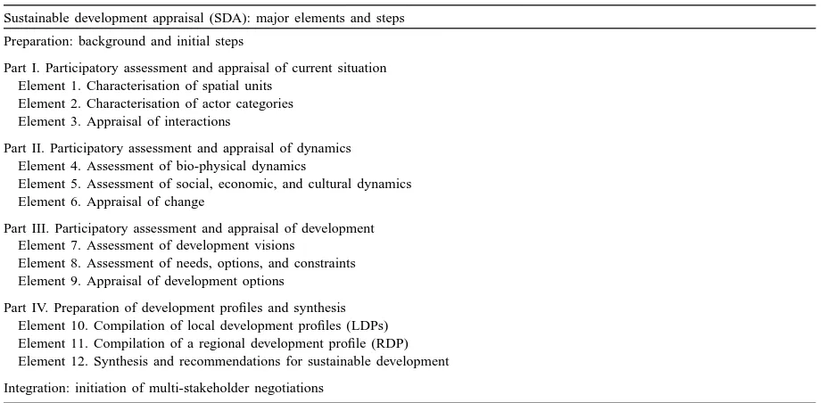
Table 1
Major elements and steps in a sustainable development appraisala
Sustainable development appraisal (SDA): major elements and steps
Preparation: background and initial steps
Part I. Participatory assessment and appraisal of current situation Element 1. Characterisation of spatial units
Element 2. Characterisation of actor categories Element 3. Appraisal of interactions
Part II. Participatory assessment and appraisal of dynamics Element 4. Assessment of bio-physical dynamics
Element 5. Assessment of social, economic, and cultural dynamics Element 6. Appraisal of change
Part III. Participatory assessment and appraisal of development Element 7. Assessment of development visions
Element 8. Assessment of needs, options, and constraints Element 9. Appraisal of development options
Part IV. Preparation of development profiles and synthesis Element 10. Compilation of local development profiles (LDPs) Element 11. Compilation of a regional development profile (RDP) Element 12. Synthesis and recommendations for sustainable development
Integration: initiation of multi-stakeholder negotiations
aEach element is outlined in the text and explained in detail in the methodology (CDE, 2000).
detail (CDE, 2000). In the first part, the focus is on a participatory assessment of existing conditions in a defined area, for example the territory of a particular community. Here, it is important to present, in a com-plementary way, a scientific, interdisciplinary assess-ment of the man–environassess-ment system, as well as local and other knowledge that stakeholders have about the people and resources of the area. The goal of the as-sessment is to define a common knowledge base which is shared and agreed by all, and serves as a starting point for development planning. The analytical steps are: the formulation of commonly perceived problems in the area, and statements of different intentions about how to achieve a common goal. This is followed by a step-by-step analysis of spatial units delimited according to common criteria such as resource status, land use types, types of access, etc, and a description of different actor categories such as land users, wealth categories, ownership categories, or external interest groups who have a claim on certain resources or land units. A detailed appraisal of interactions between and among all spatial units and actor categories is the most important step in the assessment stage.
In Part II, a participatory assessment and appraisal is made of the dynamic changes observed over time,
such as degradation processes, land use changes, ownership changes, etc. These play an essential role, as they are the results of pressure exerted on the human–environment system. The assessment of sta-tus, and pressure, and responses in the first two parts serves as a basis for negotiations on development in Part III of the SDA (Table 1). Actor categories will develop their own vision of development in a first step, which will have to be compared with other visions in order to arrive at a shared vision as a common platform for development. Needs, options, and constraints of each category, or group, of actors will be expressed in the process of discussions, and again differentiated according to spatial units within the community or area. The appraisal of the different development options will not necessarily be similar for all stakeholders involved, but will certainly help to clarify diffuse ideas and potential conflicts at an early stage. SDA is thus a tool for better land man-agement in a specific case study, and can be applied in situations where external and scientific groups are invited to assist local groups in developing their areas in a more sustainable way.
90 H. Hurni / Agriculture, Ecosystems and Environment 81 (2000) 83–92
local development profiles (LDPs) for each commu-nity area, and a regional development profile (RDP) summarising the LDPs. Both are a combinations of text, graphs, figures, and maps in a standardised for-mat, using geographic information systems (GIS) for geo-referenced information storage and retrieval. The outcomes of the SDA will serve as a basis for ini-tiating multi-stakeholder negotiations (Hurni, 1998), which will be instrumental for achieving democrati-cally acceptable solutions and for planning concrete activities. When such action is implemented with the goal of furthering SLM at the local to regional lev-els, the SDA can also serve as a baseline for impact monitoring, ex ante and at later stages.
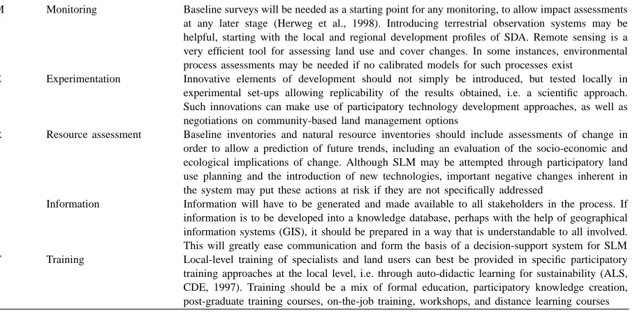
If a multi-component programme is planned as an external input into an area, it is recommendable to in-clude a number of support services accompanying the programme. Support services that may considerably enhance the quality of the work are listed under the acronym MERIT in Table 2. Although the different el-ements of the support services resemble the commonly known ‘monitoring and evaluation’ components, there are some fundamental differences in MERIT which al-low a more pro-active role to be taken by programme implementers during the activities.
Table 2
Components of support services of projects and programmes active in SLM
M Monitoring Baseline surveys will be needed as a starting point for any monitoring, to allow impact assessments at any later stage (Herweg et al., 1998). Introducing terrestrial observation systems may be helpful, starting with the local and regional development profiles of SDA. Remote sensing is a very efficient tool for assessing land use and cover changes. In some instances, environmental process assessments may be needed if no calibrated models for such processes exist
E Experimentation Innovative elements of development should not simply be introduced, but tested locally in experimental set-ups allowing replicability of the results obtained, i.e. a scientific approach. Such innovations can make use of participatory technology development approaches, as well as negotiations on community-based land management options
R Resource assessment Baseline inventories and natural resource inventories should include assessments of change in order to allow a prediction of future trends, including an evaluation of the socio-economic and ecological implications of change. Although SLM may be attempted through participatory land use planning and the introduction of new technologies, important negative changes inherent in the system may put these actions at risk if they are not specifically addressed
I Information Information will have to be generated and made available to all stakeholders in the process. If information is to be developed into a knowledge database, perhaps with the help of geographical information systems (GIS), it should be prepared in a way that is understandable to all involved. This will greatly ease communication and form the basis of a decision-support system for SLM T Training Local-level training of specialists and land users can best be provided in specific participatory training approaches at the local level, i.e. through auto-didactic learning for sustainability (ALS, CDE, 1997). Training should be a mix of formal education, participatory knowledge creation, post-graduate training courses, on-the-job training, workshops, and distance learning courses
For example, monitoring in MERIT is a built-in process which not only looks at the changes induced by programme inputs, but also, and maybe more im-portantly, at the changes occurring in the area outside of that where the programme has an impact. Distin-guishing between these two types of change can be essential in order to understand success and failure in programme activities at a later stage. Moreover, programmes very often introduce innovative ideas and technologies into an area which have not been part of the local development mechanisms. Doing this without first experimenting can have disastrous consequences, as many programmes have discov-ered. Building a component of experimentation into the support services is therefore mandatory, because innovations can then be tested and scientifically ac-companied before they are widely applied.
modelling of dynamic changes in the system will help in appraising the situation and in understanding trends in resource changes. This should be carried out at reg-ular intervals, i.e. once per year in a joint, transdisci-plinary exercise. Programme planning would then be based on the results of this exercise.
The final two elements of the MERIT support ser-vices are information and training. Monitoring, exper-imentation, and resource assessment all require solid databases and documentation, which should be made available to concerned stakeholders at any time. Train-ing, finally, should accompany programme activities for the development of a better, shared knowledge base to promote sustainable land management in a concrete context.
4. Conclusions
The concept of sustainable land management (SLM) emerged in the years following the UNCED conference held in Rio de Janeiro in 1992. Because earlier approaches did not fully respond to the re-quirement of mitigating the syndromes of land degra-dation any more, the SLM concept includes more participatory approaches, and includes the social and economic dimensions into the technical planning and design of land management approaches. In addition, it was necessary to develop new tools which are based on the concept of SLM and can help realise the prin-ciples in practical applications, i.e. where workable, long-lasting solutions are needed.
The first, conceptual step of this paper was thus to amalgamate the existing concepts relating to SLM into a framework approach in which elements such as the multi-actor perspective, the local knowledge ap-praisal, and the multi-scale approach are emphasised. The second step was to develop and field test a prac-tical tool where the participatory assessment of SLM is a core activity, and in which a geo-referenced, sci-entific database for planning and impact monitoring is realised at the same time. Since its development, the tool called ‘sustainable development appraisal’ (SDA) has proven its suitability in a variety of en-vironmental, social, and economic circumstances, and helped in the planning, monitoring, and impact assessment of concrete human interventions geared towards SLM. For project activities, finally, a specific
component was developed and field tested, consisting of a support service which contains a set of standard activities and outputs, and which has the potential to help improve the effectiveness of these projects.
References
Becker, B., 1997. Sustainability assessment. A review of values, concepts and methodological approaches. Issues in Agriculture, No. 10, CGIAR, Washington, USA, 63 pp.
Beek, K.J., de Bie, K.A.J.M., Driessen, P.M. (Eds.), 1997. Geo-information for sustainable land management. Special Congress Issue. ITC Journal 3/4, Enschede, The Netherlands, pp. 205–363.
Bellows, B., 1996. Indicators of sustainability. Workbook for the SANREM CRSP, Washington State University/University of Wisconsin, USA.
Bouma, J., 1997. The land use systems approach to planning sustainable land management at several scales. ITC Journal 3/4, Enschede, The Netherlands, pp. 237–242.
CDE, 1995. Sustainable use of natural resources. Development and Environment Reports No. 14, Centre for Development and Environment, Berne, 46 pp.
CDE, 1997. Auto-didactic learning for sustainability (ALS). Centre for Development and Environment, Berne.
CDE, 2000. Sustainable development appraisal (SDA): a metho-dological tool for the participatory assessment of sustainability from local to regional planning levels. Centre for Development and Environment (CDE), Berne.
Driessen, P.M., 1997. Biophysical sustainability of land use systems. ITC Journal 3/4, Enschede, The Netherlands, pp. 243– 247.
Dumanski, J. (Ed.), 1994. In: Proceedings of the International Workshop on Sustainable Land Management for the 21st Century, Vol. 1, Workshop summary. Agricultural Institute of Canada, Ottawa.
Dumanski, J., 1997. Criteria and indicators for land quality and sustainable land management. ITC Journal 3/4, Enschede, The Netherlands, pp. 216–222.
Dumanski, J., Gameda, S., Pieri, C., 1998. Indicators of land quality and sustainable land management. An annotated biblio-graphy. The World Bank, Washington, DC, 124 pp.
Eswaran, H., 1996. Adaptation of definition of sustainable land management from a presentation held at CDE, Berne, personal communication.
FAO, 1976. Framework for land evaluation. Soil Bulletin 32, FAO, Rome.
Herweg, K., Steiner, K., Slaats, J., 1998. Sustainable land manage-ment: guidelines for impact monitoring. Working documents for public discussion. Centre for Development and Environment, Hallerstrasse 12, 3012 Berne, Workbook, 81 pp., Toolkit Module, 121 pp.
92 H. Hurni / Agriculture, Ecosystems and Environment 81 (2000) 83–92
Conservation Organisation (ISCO) and Centre for Development and Environment (CDE), Berne, 89 pp.
Hurni, H., 1997. Concepts of sustainable land management. ITC Journal 3/4, Enschede, The Netherlands, pp. 210–215. Hurni, H., 1998. A multi-level stakeholder approach to sustainable
land management. In: Introductory keynote to the 9th ISCO Conference, Bonn. Advances in GeoEcology 31, Catena Verlag, Reiskirchen, pp. 827–836.
Muchena, F.N., van der Bliek, J., 1997. Planning sustainable land management: finding a balance between user needs and possibilities. ITC Journal 3/4, Enschede, The Netherlands, pp. 229–234.
Mueller, S., 1996. How to measure sustainability: a proposal for the agricultural and natural resources sector. Discussion paper Series on Sustainable Agriculture and Natural Resources No. 1, IICA and GtZ, Eschborn, Germany, pp. 36–55.
Pieri, C., 1997. Planning sustainable land management: the hierarchy of user needs. ITC Journal 3/4, Enschede, The Netherlands, pp. 223–228.
Pieri, C., Dumanski, J., Hamblin, A., Young, A., 1995. Land quality indicators. World Bank Discussion Paper No. 315, World Bank, Washington, DC, 51 pp.
Pretty, J.N., Guijt, I., Thompson, J., Scoones, I., 1995. Participatory learning and action. A trainers guide. IIED Participatory Methodology Series, London, UK, ISBN 1 899825 00 2. Smyth, A.J., Dumanski, J., 1993. FESLM: an international
framework for evaluating sustainable land management. World Soil Resources Report No. 73, FAO, Rome.
WBGU, 1996. Welt im Wandel. Herausforderungen für die deutsche Wissenschaft. Wissenschaftlicher Beirat der Bundesregierung Globale Umweltveränderungen (WBGU), Jahresgutachten, Berlin, Heidelberg.
WCED, 1987. Our Common Future. In: Brundtland, G.H. (Ed.), The World Commission on Environment and Development, Oxford.