PROCEEDING
THE 1st INTERNATIONAL PLANTATION CONFERENCE
Bogor,Indonesia, December
19 th_21st 2012
"Capacity Building, Development, and Sustainable Technology"
Organized
by :
Faculty of Plantation and Agrotechnology Faculty of Agriculture
Universiti Putra Malaysia Bogor Agricultural University
PROCEEDING
THE 1
stINTERNATIONAL PLANTATION CONFERENCE 2012
Bogor, Indonesia, December 19
th_21
st2012
Jointly published by :
Faculty of Agriculture, Bogor Agricultural University (2013)
Faculty of Plantation and Agrotechnology, Universiti Teknologi MARA (2013)
Address:
Faculty of Agriculture, Bogor Agricultural University Jln. Meranti Dramaga, Bogor Indonesia 16680
Tel. +62 2518629354, +62 251 8629350 Fax. +62 251 8629352
Faculty of Plantation and Agrotechnology, Universiti Teknologi MARA 40450 Shah Alarn
Selangor Darul Ehsan, Malaysia Tel: +6035543 5583
15539/5567
Fax. +6035543 5563
Editor team:
Dr. Syarifah lis Aisyah . Dr. Surya Darma Tarigan
Dr. Baba Barus.
Dr. Muhammad Syukur
Assoc. Prof. Dr. Adzmi Yacoob Dr. Mohd Yusoff Abdullah Dr. Darius El Pebrian
PROCEEDING !" INTERNATIONAL PU.\ T-I
no\"
CONFERENCE Bogar, Indonesia Decelllb er 19,/J 2 J" 2012PATIAL PATTERN OF PALM OIL DEVELOPMENT IN NORTH SUMATRA AND SOUTH K.A.LIMANTAN
ASE STUDY OF ACTUAL UTILIZATION AND LAND HOLDING STATUS
Dr Baba Barus
_セ 。イエュ・ョエ@ of Soil Science and Land Resources, Faculty of Agriculture IPB Center for Regional Planning and Development, LPPM, IPB
Email: bababarus(2V,yahoo .com or bbarus01ipb.ac.id
ABSTRACT
Oil palm plantation in Indonesia has been recognized for it's fast and wide evelopment. Its development has related to regional spatial planning, either ew develop or established area. Some problem in spatial perspective regarding
:0
problem and physical environment due to oil palm have occurred in these_'35 . This study are carried out in 2012 at several districts in North Sumatra that
gnized as an established region for oil palm area, and South Kalimantan that
セ@ )gnized as a new palm area development. Data used are actual oil palm map, _ holding status map and regional spatial planning map, and these data are ;,a.l yzed using GIS overlay method. The result shows that there are some ;lations in spatial occupation of oil palm regarding large holding company and mmunity and its impact to environment and social problem.
⦅@ セケ@ words : palm oil utilization, land holding status, spatial planning, GIS,
,\ironment problem
INTRODUCTION
Palm oil plants in North Sumatra province have been occulTed since Dutch
セZNャ@ and already established and steady number (Badrun, 2010), meanwhile palm
il plants in South Kalimantan province has started since 1990's and it tends to . crease. So far, the palm oil estates have dominated areas of some districts in lhese provinces.
Currently in Indonesia, some disputes about lands are being existed and
セ ・ョ、@ to be increased, particularly between large concession co.mpanies with local
communities, that the number is in line with the increase of investment for large holding estate (Barus and Rusdiana 2009). Many local communities have complained to local governments that their livelihood systems have been destroyed by the development of oil palm due to loss access to previously unn1anaged land, or declining of land productivity due to physical impact of current oil development and others.
So far land ownership of many farmers in Indonesia are small, and tend to be smaller due to the effect of inheritance system, agricultural land conversion for other usage (Nasoetion, 1994; Setiawan, 2008; Winoto 2011). The need for minimum size of land accessibility for community has been recognized by government through program of agrarian reform plus (Winoto 2011). Currently government of Indonesia plans to redistribute land for farmer particularly from state land .such as abandon or unproductive land of large holding status either
PROCEEDING j'1 INTERNATIONAL PLANTATION CONFERENCE
Bogor, Indonesia, December 19th 21'1 2012
from forest concession or oil palm concession. At the same time, formula for distribution of land is needed to developed (Sunito et al. 2012). However, authorization for spatial planning and its utilization belongs to local governn1ent, while legal status for large concession are managed by Ministerial of Forestry and National Land Agency, so that it creates more complex for solution.
In order to understand and develop solution, then it is important to know spatial characteristics regarding district spatial planning, actual oil palm crops, and land holding status and its potential for non oil palm crop development.
The purposes of the study are:
a. To investigate the actual occurrence of palm oil plantation and the actual large land holding status
b. To characterize of spatial pattern of district spatial planning, palm oil crop and land holding status
c. To investigate availability land for non oil palm crop development
METHODOLOGY Location of research area
The study was conducted on 3 districts in North Sumatra (Langkat, Deliserdang, and Serdang Bedagai) and 2 districts in South Kalimantan (Tanah Laut and Tanah Bumbu). The oil palm areas in North Sumatra has been estab lished since Dutch Era in Indonesia, meanwhile, the oil palm areas in South
. al imantan are just recently developed. The research area is presented in Figure
,"
ZGdセセ J@
セセ、セMGMセ[Gセ@
s
B
Figure 1. Location of research area: (a) North Sumatra and (b) South Kalimantan rE
Data and tools \.\
a!
Several maps used in the research: Palm oil map (2010, Mapping of Some
Perennial Crops, Ministry of Agriculture); Several draft district spatial planning ar
b{
(2012, District of Planning); Land holding status (2012, National Land Agency);cl Land permit (2012, Districts Office), Land system (RePPProT, 1989). All maps
have scale I: 50,000 or larger, except Land system map with scale 1 :250,000. cc stc Field observation was conducted on August September 2012 with focused on
selected physical environment and socioeconomic observation . co
[image:5.611.92.515.427.597.2]
PROCEEDING j'1 INTERNATIONAL PLAS T-4 T1U\ -COSFERENCE
Bogar, Indol7esio, D ec-! lII nf:'r II/'If 2 j'1 2012
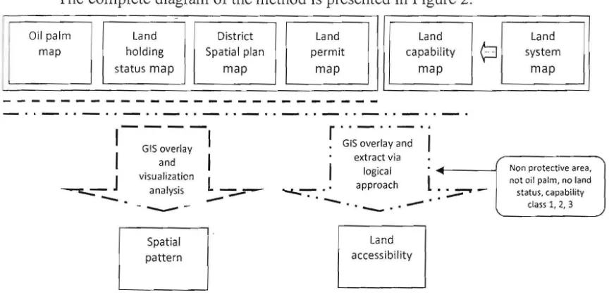
lethod for analysis
The first is to figure out a spatial pattern of oil palm crop regarding status
...セ ャ 、@ spatial planning, then the maps of oil palm, land holding status, district spatial
r IJ nning and land permit are overlaid. Distribution occurrence of oil palm crop
regarding its land status is observed visually and quantified statistically. After bat, from the map, a relation between legal status and spatial planning and oil , 11m is extracted, and observed spatially.
The next method is to develop land accessibility for non oil palm crop. The GIS overlaid method is implemented, then some further extractions are
セ。 イイゥ・、@ out. The extraction rules are: the available land has to be located in non
, rotective area, currently not as oil palm plantation, not as settlement, no legal occupation status (large holding company or land permit), and land capability .:l ass I, 2, 3. Land capability classes follow criteria of USDA and modified by A,rsyad (2000), where class I, 2 and 3 potential for agricultural utilization. The result of the overlay method is then visually observed and statistically quantified.
The complete diagram of the method is presented in Figure 2.
I
: I
Oil palm Land District Land Land Land
map holding Spatial plan permit capability
¢J
systemstatus map map map map map
r"-"-GIS overlay and GIS overlay
extract via and
logical visualization
approach
_ J analysis
l_
•l .. ..,... _
---
-...c...-:-.'_
_ . , _
---.:...::
-
.
" _ . ,Land Spatial
accessibility pattern
Non protective area. not oil palm, no land status, capability
class 1, 2, 3
Figure 2. Illustration of method implemented in the research
RESULTS AND DISCUSSION
Spatial Pattern of Oil Palm in North Sumatra
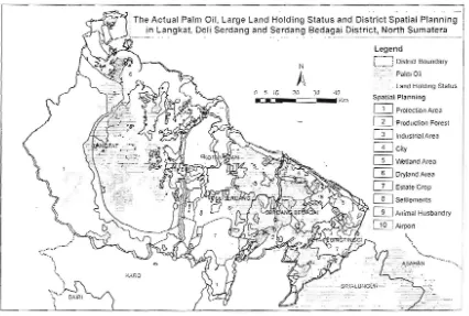
Figure 3 exhibits the actual oil palm dominantly in Langkat and Serdang Bedagai district, and less areas in Delisedang district. One important reason is related to closeness of Deliserdang District to Medan, Capital city of province, where settlements are dominant in the area. Based on the field observation, some agricultural areas of Serdang Bedagai, where a new air port is being developed, are considered to be converted . It is predicted in the next several years these areas become build up areas. However, in these areas some land disputes are very clearly visible through many claims of ownership of such as land, both from local community or some non government organization or companies and others. The staff of land agency and district secretariat also claims some conflicts between community with large concession oil palm company. In general, land disputes
[image:6.611.84.516.297.508.2]PROCEEDING]" INTERNATIONAL PLANTATION CONFERENCE
Bogar, Indonesia, December 191ft _2]'1 2012
more common occur in Deliserdang, following in Serdang Bedagai and the least in Langkat.
In term of legal status for actual oil palm, Figure 3 shows some information, that many oil palm estates in North Sumatra do not have legal status or belong to small holding company. The picture shows that the number of large holding (HGU Hak Guna Usaha) spatially is less compared to occurrence of oil palm estate (see also Appendix). Based on field observation, many oil palm estates particularly in Langkat are owned by rich people, with sizes of estate is more than 25 Ha. According to Indonesian regulations (Act of Agrarian Law, No 5, 1960; Ministerial of Agriculture Decree, No 26, 2007), the oil palm with size more than 25 ha, should be legalized as a large holding status, and then it is obligated to have a patiicular legal occupation, such as HGU. However, some ownership of these oil palm estates questioning about the impoliance of HGU, as most of them do no need further budget from the bank, where generally HGU is used for guarantee (morgate). In addition, they mention also the difficulty in obtaining HGU certificate.
The Actual Palm Oil, Large Land Holding Status and District Spatial pャ。ョセゥョァ@ G ャ@
. in Langkat. Deli Serdang and Serdang 8edagai District, North Sumatera
Legend
lNᄋセNMNMj@ District Boundary
A
N
Palm Oil
. Land Hold ing Sialus t15iG 2(, J;J 4(1
Spalial Planning
.--_ _ K m
セ Prolection Area IT] Production Fores!
IT] Industrial Area Q]City
m
INetiand Areao
Dryland AreaQ] Estate Crop
CD
Seillementsm
Animal Husbandry . セaゥ イ ーッイエ@t.,_
". ".
". KARO
Nセ@ \\
,. .セ@ \"'" Ot.IRI
[image:7.611.101.527.305.592.2]i
Figure 3. Spatial pattern of Oil palm and Land status regarding Spatial Planning in North Sumatra
Another paradox from spatial character can be seen from the occurrence of land hold status at spatial zone and the existence of actual oil palm is not located in proper spatial zone. Figure 3 shows few land holding status (HGU) locates ir. the conservation area, particularly in Langkat District, and few land holding status at dry land agriculture zone but no actual oil palm crops. The first case, there i_ no impact for land use forest conversion or land degradation, however this dat r. shows some improper implementation in the development. The second case, lana holding without actual crop, this may be related to neglected land (lahm
e
1c
1,
118
;ast
'me ttus rge . oil
lim
IS
No lze
: IS
me as
r is
In
lOing
セイ。@
lory
Stalus
'a
fe st
Idry
"' .
1
f I
PROCEEDING 1" INTER-\. -1 Til JY -l L F'L-l .\7 .-i TlOS CONFERENCE
Bu\!.ur Iildoiiesia. De celll ber 19'/J
21"
2012!riantar), where currently, Indonesian Go vernme nt \\ an ts to allocate such as land
'.0 other utilizations and become a target for agrari an reform.
Furthermore, the existence of actu al oil palm in many places that not in tne with the district spatial planning occulTi ng in the three districts, This situation may relate to at least two situations , are : (a) people do not follow spatial planning n their activities, and (b) improper spatial planning development. Some land uses
do not in line with spatial planning, indi cate by some oil palm estates locate in the \\etland zone, dry land zone and forest production zone, The occurrence of oil palm crop in wetland zone currently become national problem due to its potential hazard to secure food security, compare to its occurrence in dry land and forest production area. Based on limited discussion in the field, some people do not
セ」」ッァョゥコ・@ the existing spatial plan, and some of them consider for economy
benefit after conversion . In this case, land rent of paddy is less than land rent of oil palm. Similar argument is valid for the existence of oil palm in dry land and forest production area.
Furthermore, the improper spatial planning development can be stated as another reason for occurrence of some oil palm estates in some places. From discussion with several staffs in the office of districts spatial planning, appears some reasons for spatial inconsistencies. One, the cunent spatial plan was revised through the central government assistance and the provincial project (bantuan
reknis dari Kementrian PU dan Provinsi), without field observation particularly
for actual land use and without detail data of physical character. Second, the data used was secondary data, that it generally contained less detail such as physical data.
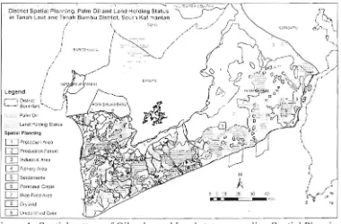
Spatial Pattern in the South Kalimantan
Figure 4 exhibits the actual oil palm distribution almost evenly in southern areas of both districts, Tanah Laut and Tanah Bumbu. The relative evenly distributed of the oil palm relates to the emergence of oil palm as potential economic sources, and many companies invest in oil palm industry . So far, some land disputes are being arisen also here, '· but it has less number compares to the land dispute in North Sumatra.
PROCEEDING ]'1INTERNATIONAL PLANTATION CONFERENCE
Bogar, Indonesia. December 19,h 2]" 2012
Di;tri ct sー。エゥセQ@ Planning ." p a lm Oil an d セ。ョ、@ Hoiding Stat:' G セ[LM GLッ GGGG@ GGG イセ@
. in TanJh Laut 30d Tan.ah Nbオ@ ャャQ セオ@ dゥウエイセ」エN@ So ulh KJ.limantan セ ⦅⦅@ / /
i ::;:' ,:
. ? almO:t
Spatial Planning
セ p イ c ゥ セ」エ i o G[@ Are.,
[TI p イッ Nェ セ イ 」 エャッョ@ f ッ イ GSセZ@ CD Indu!;! rl<lI.l\ret:J
o
r-Isher.' [|Nイセ。@UJsememems
m
P arennt c1.1 cセo[j s@ [image:9.611.126.506.73.323.2][IJRice Freid .-\( 1:;) W C;Y;fI;)j [TI lG エQ@ Z 」GᄋNセ ャャ[{NN」j@ Di'ta
Figure 4. Spatial pattern of Oil palm and Land status regarding Spatial Planning in South Borneo
During field discussion, some local people already complain about the legal status of oil palm concessions. In the past the local people do not intent to manage large si ze of land and use it as they need. A family usually manages in ensi\ ely less than one hectare land, but at the same time one also has an access to unma naged land for other utilizations, such as for fire works, building, etc. As man; unmanaged lands, that in the past it might be owned by local people or go\'errunent land, have been converted into oil palm crops or other intensive usages particularly for coal mine, then the local people are facing less resources and willing to have more resources. During the year of 2011, several complains have been occurred and dispute between oil palm company and people, and it tends to increase.
From legal status perspective, Figure 5 shows that dominant oil palm estates in South Kalimantan have legal status, only few of oil palm estates do not have legal status. The picture shows that dominant of large holding status (HOU
Hak Guna Usaha) have overlapped areas with the actual oil palm crops.
However, the fact is many of the actual oil crops locate outside of the boundary of legal status. Based on field finding, dominant of the ownership of oil palm belong to big companies, but some of them have a good relation with community. This is tied to oil palm following PIRBUN type or Core Plasma type development (plasma concept). So far, in the area without plasma concept, some land disputes between local people and company occur.
A paradox also can be seen from the occuri·ence of land hold status in improper zone and the existence of actual oil palm is not located in proper spatial zone. Figure 4 shows few land holding status (HOU) locate in the conservation area, particularly in Tanah Bumbu District, and few land holding status are located at the wetland, dry land agriculture and forest production zone but without actual oil palm crops. The first case, there is no impact for land use forest conversion or land degradation, however this data shows some improper
PROCEEDING]" INTEKY .J.!i( I.'..!!.. pi... .\}.J. Ti o.\ CONFERENCE
bNBセ NB Zャイ@ i,!JOT;<'.';.:. Dt'c C'lI7 oer 19'11 ..21" 2012
implementations in the deve lopment The sC(l.nd ca se, land holding without actual crop, this may categorise as ョ ・ ァ ォGZM Z セャセ@ la nd (1 017011 ferlontar), where currently, Indonesian Go vernment \\ 3lli :3 [0 alloc ate such as land to other
utilization and become a target for agrari an re fo m!.
Furthermore, the existence of actua l o il palm in so me places that not in line with the district spatial planning oc curr ing in these two districts. This situation relate may to at least two situations. are: (a) people do not follow spatial planning in their activities, and (b) imprope r spatial planning development. Some land utilizations do not follow the existing spatial planning, indicate by some oil palm estates locate in the wetland zone, dry land zone and forest production zone. The occurrence of oil palm crop in wetland currently become national problem due to its potential hazard to secure food security, compare to its occurrence in dry land and forest production area. Based on limited discussion in the field, some people do not follow theexisting spatial plan, and some of them consider more for economy benefit after conversion. In this case, land rent of paddy is less than land rent of oil palm. Similar argument is valid for the existence of oil palm crop in dry land and forest production area.
Furthermore, the improper spatial planning development can be stated as another reason for occurrences of oil palm crops in some places. From the discussion with staffs in the office of districts spatial planning, appears some reasons for spatial inconsistencies. There are at least three reasons found. The first, the lack consideration of the importance of detail data. So far detail of physical data is not put properly, and is not supported by sufficient data. The second, politicaleconomy factor is more important, and proper technical issue has no place in decision. The third, the lack of socialization of spatial planning to community.
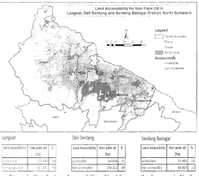
Land accessibility for non oil palm in North Sumatra
Land accessibility for non palm crops in North Sumatra can be seen in Figure 5. This figure shows that some areas in these three districts are accessible for non palm crops , The areas in Langkat and Deliserdang has in compact shape compare the areas in Serdang Bedagai. However, the largest access land is available in Langkat, and follow in Serdang Bedagai and the smallest area in Deliserdang. If we refer to problem of land dispute at these three districts, then this situation is understood, as the highest land dispute is Deliserdang and less in Serdang Bedagai, and the smallest in Langkat. This figure proves that the lack of land accessibility to local community may still come, as the need of land for some local community for their livelihoods. From field finding, many communities want to have access land from expired land holding status, as people perception that when a legal status of concession has been expired, then such land will be a agrarian subject of reform, and it may distribute to community.
PROCEEDING]'/ INTERNATIONAL PLANTATION CONFERENCE
Bogar, Indonesia. December 19'" _211/ 2012
Land Accessibility for Non Palm Oil in
Langkat, Deli Serdang and Serdang Bedagai District, North Sumatera
Legend
! ェ セ@ ..
[image:11.611.99.502.74.431.2]• , j "
...
oJ '$ . ,) :c ;:) d::,
ICI: セB N@
Langkat Deli Serdang Serdang Bedagai
land Accessibility Non palm oil
(hal %
S4 ,938 31
19 0.522 69
land Accessibility Non palm oil
(hal %
Non 。」」」ウU ェ@ 「ャセ@ 66,023 42
- '. ' :,. Gセ@
Figure 5. Distribution of accessibility ofland for non oil palm crops in North Sumatra
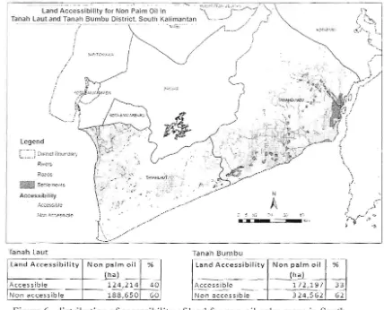
Land accessibility for n!>noil palm crop in South Kalimantan
Land accessibility for non palm crops in South Kalimantan can be seen in Figure 6. This figure shows that some areas in these two districts are accessible for non palm crops. The potential available areas in Tanah Bumbu has large size and compact shape compare to the areas in Tanah Laut, that has smaller in size and distribute evenly. The reason to this situation may relate to just recent development of oil palm crops in Tanah Bumbu compare to Tanah Laut. Beside that, Tanah bumbu is a relatively new district compare to more established district status at Tanah laut. So far the problem of land disputes occurs more in Tanah Bumbu, than in Tanah Laut. However, as land accessibility is larger in Tanah Bumbu, so that solving through land distribution is easier in Tanah Bumbu, despaite it is still possible in both districts. So far, one other real problem in both districts are conflict with land mining for coal. Recently, land dispute are arisen not just from community but also from coal mine company.
r
c
t c
i
/C/
Iセ|@
,O;M";;,',"' """
N ェ@ Dls;r!c t
80ur'c3r,-r...."i/Joi L.\UT.=:i. · S=t!le :nel )! S
.- :':'- - ;,,'
•
セ sゥl[ ャ@ ・@ i Nセ N@ Gヲ@ GZ ZZャセ@ ウウ、 j i[ZZ@
_.-1- ,,- / '
, /
PR OCEEDING
I"
IN TER}lATIONAL PLA :\''TATJO\ CONFERENCEBogor. Indollesio, Decelllber 19'" -21" 2012
"T '' BG GGG MG G G Mセ Z セQ GG@ \)' \ ;">
, ' , -\ ) , セ G
G@
Palm all In tan \. , _ , / O- A
セ cセ セsャ「ャャャエケ@
for NOtrnlct Southkセ iiヲtセ。ョ@
O
セ ⦅ OLG@
B@ ZセN@nd Tan all Bumbu_ DI S
Lッ@
,, ;. \.,""'.;..Land _
セG
t. ... ,T,",hL""
rセ@
.. ),,·Y:' f · ,< , :....:../...'
t
I / / / "
-
.I
'
/ , \ ,.I
^ LL セ NN@
i l l ' .. ..,. "'-"<:i
" I
Nセ@ ./I "
セ Gャ@
,..
' e. , • • ..J ,... ... '
,-' - - 't :'.<:! ,\'
. /
セ
5 ..-セN
,-..JN@ セN
"ゥGB@
1/ '
I|セ
- ," " " J , :7'" ,, '" ( i!I '" 1 _ ,jセ@
( [ iGZcG j [Nェi BLゥjゥ Gセ BBGセG@
I
I .. " , ', / " ''':' \ . ..l C -{ . : ( <' I i,.../
_ "_)
セ@
_'\. .."
..I )セ@
/ , " , ' i,[LセgIサ
⦅セ⦅@Lセセイ | L^
___--, (
, - " " L , • ,/ ,
legend A .' I \ -" - - ;b\ --r
I,
セ@
'" , J., c:F" 'J I . / "'"
セ
B@
B@
....; ' . ' <...!.. " \cBN G⦅ セG NG@ ' ",-' lilt セ セ Lセ セ :1!fP/ \
.
'"7
r, t"
j セ _ ⦅@.,
R,ve rs
セ o 」cs@ .
. ) J
i
_*>'
N
(
Z ゥ セ@ J .
iBNセ@ ᄋ@
Accessibility
J N セ•.
.. ..-. /
a 」 」・
/ '
A
i .. ,)c "
QGQセ ゥQ@ Nセ@ c ;:. 1(;: Z L⦅ セ@ ::..:' .1) NL セ エG セ Nイ@ .,
_ . ;{! ": セ@ if :'7
..)
Tanah l aut Tanah Bumbu
r , ,' -Land Accessibility Non palm oil ' %
(hal
Ac cess i ble 1 2 4 , 214 4 0 N o n accessibl e '- 1 8 8,650 60 1
Land Accessibility Non palm oil (hal
%
[image:12.611.108.536.81.427.2]Acc essible 172 , 197 33 N o n a cc es s ible 3 2 4 , 5 6 2 62
Figure 6. distribution of accessibility of land for nonoil palm crops in South Kalimantan
There are four problems related to the spatial oil palm development in these two provinces . The problems are related to (a) law enforcement for formalization of large ownership status, (b) illegal occupation, (c) gap land ownership and small size, and (d) improper spatial planning.
The pattern of oil palm development in both provinces are different. Although the oil palm development has been longer in North Sumatra, but the problem of land conflict is higher here and many breaching of legal status, particularly for disobey of owner to have HOU certificate, beside many conflicts between communities and companies as the occurences of community claiming for more lands for their livelihoods. The fact , the potential lands to be accessed by community is less in North Sumatra compare to land accessed in South Kalimantan, This relates to already large occupant of oil palm in North Sumatra. The major different also exhibits in legal status of oil palm estate. Many oil palm estates in North Sumatra without legal formal as large land ownership status means many loss of potential income from government perspectives , The number oil palm out of legal status boundary in South Kalimantan is less.
Furthermore, in Deli serdang and Serdang Bedagai districts, some illegal land occupations occur, particularly at near the new Air Port of Kuala Namu, or in the water catchment areas / protection areas in oil palm estates, The illegal occupation occurs mostly in the state onwer of oil palm (PTPerkebunan Negara) ,
PROCEEDING 1" INTERNATIONAL PLANTATION CONFERENCE Bogar. indonesia, December 19'h -21'" 2012
and in the field it is managed by organized community, who want to speculate potency for land ownership. Meanwhile the illegal occupations in the protection area that common in private oil palm estates are managed by local community, and probably it purely relates to basic economy reason. According to the district staff in North Sumatra, many reasons for the occurrence of land disputes, but the need of larger land for livelihood become prominent as the increase of population; and community know about regulation in Agrarian Reform in Indonesia that when a large holding status has been expired, then government will consider to distribute such as land to particular community.
The spatial planning can be used as means to manage proper development in line with environment. So far, based on the spatial planning observation and discussion with local government staff, it figures out that some of actual spatial planning data have neither consider a proper community need for space, nor a proper consideration of physical carrying capacity. One importance reason is the lack of detail or proper data. Some spatial zone that are developed without proper consideration for its function for local people, and new development may degrade other areas when it operates.
As current picture of oil palm development in both provinces produces some negative situations then some solutions are needed to consider, are (a) a need formulation to balance ownership between community and large holding company , (b) a new method for land distribution and investment. The new formulation can be directly from calculation community need for land and prediction actual land availability spatially. The method for distribution of land shoul d first direct to direct development of local community rather consider for in ve 'tm ent conside!'ation.
CONCLUSION
Some conclusions from this research are:
a. Largely distribution of the oil palm crops in North Sumatra concentrate in Langkat and Serdang Bedagai, and oil palm estates in Deli serdang is less , and it might be related to conversion, while the oil palm crops in South Kalimantan distribute in Tanah laut and Tanah bumbu evenly.
b. The number legal status of land holding estate is higher and distribute evenly in South Kalimantan than the number of legal status of land holding, which imply owners of oil palm estates in South Kalimantan is better in obeying of land regulation
c. The district spatial planning in both provinces are not completely in line with both the actual oil palm occurrences and it's legal status
d. Some indications of the problem in physical and socioculture have found in both provinces that indicated from occurrences of land disputes and illegal occupations
e. There are need a particular in balancing of land ownership of land or oil palm crop and supported by spatial planning
E
N
Pe
Se
Sur
Wir
Und:
PROCEEDING 1" INTERN4.TIOY -'tL iL:YT..J Tl OV CONFERENCE Bogoi o in,/o /'';' :: I. LJ..!cL'lII ber 19,h 211' 2012
REFERENCES
Badrun, M. 2010. Tonggak Perubahan : mela lui PIR Kelapa Sawit Membangun Negeri . Direktorat Jenderal Perkebunan , Kementrian Pertanian, RI. Barus, E. and O. Rusdiana, 2009. Development and Policy for Large Scale Land
Occupation in Kalimantan Before and After the Decentralization System. Presented in the Second IRSA International Institute, Bogor, July 2123, 2009 .
Barus, B. 2010. Daerah Potensi Konflik Lahan Perkebunan Sawit, Hutan Alami, dan Gambut yang berpengaruh terhadap lingkungan. Workshop3: Implementasi KLHS/SEA terhadap Rencana Pengembangan Kelapa Sawit; diselenggarakan oleh Bappenas di Bali, 23 November 2010
B. Barus, K. Gandasasmita, B.H. Trisasongko, Diar Shiddiq, LS. Iman, dan R. Kusumo, 2011. Pemanfaatan Ruang Daerah Gambut untuk Perkebunan Kelapa Sawit di Provinsi Riau dan Kalimantan Tengah. Prosiding Mapin, Undip Semarang
Nasoetion, L.r. 1994. Kebijakan Pertanaban Nasional dalam Mendukung Pembangunan Ekonomi: Pengalaman Masa lalu, Tantangan dan Arah ke Masa Depan. Orasi Guru Besar Ilmu Tanah, IPE.
Peraturan Menteri Pertanian, No 26, tabun 2007, tentang Pedoman Perizinan Usaha Perkebunan.
Setiawan, U. 2008 . Dinamika Reforma Agraria di Indonesia Setelah Orde Baru.
Dalam Dua Abad Penguasaan Tanab: Pola Penguasaan Tanah Pertanian
di Jawa dari Masa ke Masa, (Tjondronegoro, SMP dan G. Wiradi , editor). Yayasan Obor Indonesia
Sunito, S. , B. Barus, N.F. Rachman, B.E.Yulian, Indriayati , Suryalita dan Munsyarief. 2012. Batasan Luas Pemiikan dan Penguasaan Tanah: Fokus Studi pada Hak Guna Usaha. Laporan akhir. Kerjasama Pusat Penelitian dan Pengembangan, BPN dengan Fakultas Ekologi Manusia, IPB
Winoto, J. 2011. Ekonomi Politik Keagrariaan Nasional: Memmbangun Ruang-ruang Politik Keadilan, Kesejahteraan, Keberlanjutan dan Harmoni Sosial.
Keynote Speech pada Seminar Nasional Pekan Ilmiah Himpunan
Mabasiswa Ilmu Tanah, IPB.
Undang Undang No.5 Tahun 1960, Tentang : Peraturan Dasar Pokokpokok Agraria.