EVALUATION
(Case Study in Musi Banyuasin Regency, South Sumatra Province)
YUDI ASTONI
GRADUATE SCHOOL
BOGOR AGRICULTURAL UNIVERSITY
BOGOR
I, Yudi Astoni, hereby stated that this thesis entitled:
DETERMINING OIL PALM PLANTATION POTENTIAL LOCATION USING SPATIAL MULTI-CRITERIA EVALUATION
(Case Study in Musi Banyuasin Regency, South Sumatra Province)
Is result of my own work under the supervision advisory board during the period February until July 2011 and that it has not been published before. The content of the thesis has been examined by the advising the advisory board and external examiner.
Bogor, August 2011
Yudi Astoni
YUDI ASTONI. Determining Oil Palm Plantation Potential Location Using Spatial Multi-Criteria Evaluation (Case Study in Musi Banyuasin Regency, South Sumatra Province). Under the Supervision of SURIA DARMA TARIGAN and HARTANTO SANJAYA
Indonesia has the potential land to grow oil palm plantation and currently being the largest producer of crude palm oil (CPO). Satellite remote sensing data is very potential to be used in studies of forest conditions and plantation, because remote sensing data gives current and accurate information. Sumatra Island, especially Musi Banyuasin regency is one of area that has potential for oil palm plantation development. The objective of this research is to determine the potential location of oil palm plantation development by considering bio-physical criteria such as climate suitability, land condition, and accessibility in Musi Banyuasin regency, and to evaluate the suitability map of oil palm plantation that obtained compared with existing plantation in Musi Banyuasin regency. The Method of this research is based on multi criteria decision making by implementing GIS model technology using spatial multi criteria evaluation that will determine location of oil palm plantation potential. Each criterion and alternatives should be evaluated and weighted using pairwise comparison method to determine the best location for oil palm plantation potential in Musi Banyuasin Regency. Geographic Information System (GIS) analysis using Spatial Multi Criteria Evaluation (SMCE) in finding the best location for oil palm plantation succeeded to choose Sungai Lilin Sub-District as the best location for oil palm plantation development. Sungai Lilin Sub-District has the total suitability area of 62,246.37 Ha or 20.30% of Musi Banyuasin area. Based on the calculation area and percentage of suitability map and existing oil palm plantation indicated that area Highly Suitable (S1) for development plantation area is 306,612.42 ha or 21.23% of Musi Banyuasin regency and for the existing plantation area is 223,699.66 ha or 15.49%.
YUDI ASTONI. Menentukan Lokasi Potensial Perkebunan Kelapa Sawit menggunakan evaluasi spasial multi kriteria (Studi Kasus di Kabupaten Musi Banyuasin, Propinsi Sumatera Selatan). Dibimbing oleh SURIA DARMA TARIGAN dan HARTANTO SANJAYA
Indonesia memiliki lahan yang potensial untuk pertumbuhan perkebunan kelapa sawit dan saat ini menjadi produsen terbesar minyak sawit mentah (CPO). Data satelit penginderaan jauh sangat potensial untuk digunakan dalam penelitian tentang kondisi hutan dan perkebunan, karena data penginderaan jauh memberikan informasi terbaru dan akurat. Pulau Sumatera, khususnya Kabupaten Musi Banyuasin adalah salah satu daerah yang memiliki potensi untuk pengembangan perkebunan kelapa sawit. Tujuan dari penelitian ini adalah untuk menentukan lokasi potensial pengembangan perkebunan kelapa sawit dengan mempertimbangkan kriteria bio-fisik seperti kesesuaian iklim, kondisi lahan, dan aksesibilitas di Kabupaten Musi Banyuasin, dan untuk mengevaluasi peta kesesuaian perkebunan kelapa sawit yang diperoleh dibandingkan dengan perkebunan yang ada di Kabupaten Musi Banyuasin. Metode penelitian didasarkan pada keputusan multi-kriteria yang menerapkan teknologi permodelan Sistem Informasi Geografis dengan menggunakan evaluasi spasial multi-kriteria yang akan menentukan lokasi potensial perkebunan kelapa sawit. Setiap kriteria dan alternatif harus dievaluasi dan berbobot menggunakan metode perbandingan berpasangan untuk menentukan lokasi terbaik untuk potensi perkebunan kelapa sawit di Kabupaten Musi Banyuasin. Analisis Sistem Informasi Geografis (GIS) dengan menggunakan evaluasi spasial multi kriteria (SMCE) dalam mencari lokasi terbaik untuk perkebunan kelapa sawit berhasil memilih kecamatan Sungai Lilin sebagai lokasi terbaik untuk pengembangan perkebunan kelapa sawit. kecamatan Sungai Lilin memiliki luas daerah kesesuaian 62.246,37 Ha atau 20.30% dari total luas kabupaten Musi Banyuasin. Berdasarkan perhitungan luas area dan persentase peta kesesuaian dan perkebunan kelapa sawit yang ada menunjukkan bahwa wilayah Sangat Cocok (S1) untuk pengembangan daerah perkebunan 306.612,42 ha atau 21.23% dari kabupaten Musi Banyuasin dan untuk daerah perkebunan yang ada 223.699,66 ha atau 15.49%.
YUDI ASTONI. Determining Oil Palm Plantation Potential Location Using Spatial Multi-Criteria Evaluation (Case Study in Musi Banyuasin Regency, South Sumatra Province). Under the Supervision of SURIA DARMA TARIGAN and HARTANTO SANJAYA
Indonesia has the potential land to grow oil palm plantation and currently being the largest producer of crude palm oil (CPO). Satellite remote sensing data is very potential to be used in studies of forest conditions and plantation, because remote sensing data gives current and accurate information. Sumatra Island, especially Musi Banyuasin regency is one of area that has potential for oil palm plantation development.
The objective of this research is to determine the potential location of oil palm plantation development by considering bio-physical criteria such as climate suitability, land condition, and accessibility in Musi Banyuasin regency. And to evaluate the suitability map of oil palm plantation that obtained compared with existing plantation in Musi Banyuasin regency. This research was conducted from February to July 2011 including the data preparation, data processing, and developing method. The processing of this data was conducted in the laboratory of MIT IPB SEAMEO BIOTROP, Bogor. The study site in this research is in Musi Banyuasin Regency, located at 1.30 - 40 S, 1030 - 1050 E.
The Method of this research is based on multi criteria decision making by implementing GIS model technology using spatial multi criteria evaluation that will determine location of oil palm plantation potential. Each criterion and alternatives should be evaluated and weighted using pairwise comparison method to determine the best location for oil palm plantation potential in Musi Banyuasin Regency. Multi-criteria evaluation is a technique in decision making using multiple criteria or scenarios. Multi-criteria evaluation function is to assist policymakers in choosing from several alternatives based on the priority scale. in this study made three alternative scenarios or weighting based on the priority scale for the development of potential locations of oil palm Plantations in Musi Banyuasin regency by assigning the weights based on the opinion of expert , local knowledge and giving equal weight to each criterion (average value). Based on the results of the calculation of the area by comparing several alternatives it can be concluded that alternative or scenario from expert is the best solution for the development of oil palm plantations in Musi Banyuasin regency.
58,558.68 ha or 19.10% of suitability area, while Sekayu Sub-District only covers 56,466.3 Ha or 18.4% of the total Musi Banyuasin Regency. Based on the calculation area and percentage of suitability map and existing oil palm plantation indicated that area Highly Suitable (S1) for area plantation development is 306,612.42 ha or 21.23% of Musi Banyuasin regency and for the existing plantation area is 223,699.66 ha or 15.49%.
Copyright © 2011, Bogor Agricultural University Copyright are protected by law,
1. It is prohibited to cite all of part of this thesis without referring to and mentioning the source;
a. Citation only permitted for the sake of education, research, scientific writing, report writing, critical writing or reviewing scientific problem
b. Citation does not inflict the name and honor of Bogor Agricultural University.
EVALUATION
(Case Study in Musi Banyuasin Regency, South Sumatra Province)
YUDI ASTONI
A thesis submitted for the degree Master of Science in Information Technology for Natural Resources Management Study Program
GRADUATE SCHOOL
BOGOR AGRICULTURAL UNIVERSITY
BOGOR
Musi Banyuasin Regency, South Sumatra Province)
Student Name : Yudi Astoni Student ID : G051090041
Study Program : Master of Science in Information Technology for Natural Resources Management
Approved by, Advisory Board
Dr. Ir. Suria Darma Tarigan, M.Sc
Supervisor Co-Supervisor
Hartanto Sanjaya, S.Si, M.Sc
Endorsed by,
Program Coordinator Dean of the Graduate School
Dr. Ir. Hartrisari Hardjomidjojo, DEA Dr. Ir. Dahrul Syah, M.Sc.Agr
Alhamdulillah, Thanks to The Almighty ALLAH SWT, which has given me the opportunity and ability to complete this thesis. The success of this study would not have been possible without various contributions and supports from many people and I will not be able to mention them one by one. Of course, I would like to express my highly appreciation to all of them.
I would like to express my thanks and sincere appreciation to Ministry of Agriculture Indonesia for giving me the opportunity to continue my studies and providing the financial support essential for overall expenses during the whole study at Master of Science in Information Technology for Natural Resources Management, Bogor Agricultural University.
I wish to thank my supervisor, Dr. Ir. Suria Darma Tarigan, M.Sc and my co-supervisor, Hartanto Sanjaya, S.Si, M.Sc for their guidance, supporting and kindly provided me the valuable advice of my research. Moreover, I would like to express my gratitude to the external examiner Prof. Dr. Ir. Lilik Budi Prasetyo, M.Sc for giving advice and valuable correction to make my thesis acceptable.
I would like to thank Regional Planning Agency (BAPPEDA) of Musi Banyuasin Regency for supporting in obtained field data during my research.
I would like to thank all staffs at MIT secretariat that support our administration, technical and facility. I would also thank all MIT lecturers who taught me with very important knowledge during my study.
I would like also thank all my colleagues in MIT (especially MIT 2009) for helping, supporting, and togetherness in finishing our assignment and study during accomplish our master degree.
Finally, I would like to thank my lovely wife Nurlaili my boy Muhammad Giovanni Vallendra and my parents for all moral their support, patience, prayer and love during my study.
Hopefully, this thesis could give positive and valuable contribution for anyone who reads it.
Bogor, August 2011
Page
TABLE OF CONTENTS ………. xi
LIST OF TABLE……….. xiv
LIST OF FIGURES……….. xv
LIST OF APPENDICES……….. xvi
I. INTRODUCTION ………..……… 1
2.1 Geographic Information System ………..……… 3
2.2 GIS for land Suitability Analysis………..…… 3
2.3 Spatial Multi Criteria Evaluation (SMCE) Method…….…… 5
2.4 Oil Palm and Potential Land Suitability……… 6
III. METHODOLOGY………..… 9
3.1 Time and Location ……….………….. 9 3.2 Data and Tools Requirements………...
3.2.1 Data Needs……….… 3.2.2 Hardware and Software Requirements………..
10 10 11 3.3 Method……….……….………
3.3.1 Definition of Goal and Objectives……..………... 3.3.2 Identification and Grouping of Criteria (Factor and
Constrains)……….….………...… 3.3.2.1 Climate Factor……….……… 3.3.2.2 Land Condition Factor ……… 3.3.2.3 Accessibility Factor ………..…..…… 3.3.2.4 Constrains Factor ……… 3.3.3 Preparation of Maps for Each Factors and Constraints.…
3.3.5 GIS-Spatial Multi Criteria Evaluation………...… IV. RESULTS AND DISCUSSIONS ………..……
4.1 Suitability Evaluation ………. 4.1.1 Climate Suitability Map ………..… 4.1.1.1 Rainfall Map ……….… 4.1.1.2 Temperature Map ……….… 4.1.2 Land Suitability Map ………..
4.1.2.1 Soil Type Map ……….…. 4.1.2.2 River Map ……….…… 4.1.2.3 Slope Map ……….… 4.1.3 Access Suitability Map ………
4.1.3.1 Road Map ………..… 4.1.3.2 Factory Location Map ……… 4.1.4 Generating Constrains Map ……….… 4.1.4.1 Settlement Map ………..… 4.1.4.2 Protected Forest Map………..… 4.1.4.3 Water Body Map ……..………..…… 4.1.4.4 Paddy Field Map ……… 4.2 Weighting Based on Pairwise Comparison Matrix ...
4.2.1 Climate Suitability Factor ……… 4.2.2 Land Condition Factor ………. 4.2.3 Accessibility Factor ………. 4.2.4 Suitability of Oil Palm Plantation Factor ……….… 4.3
GIS-Spatial Multi Criteria Evaluation……….…
4.3.1 Suitability Assessment ……….… 4.3.1.1 Assessment based on Expert ………..… 4.3.1.2 Assessment based on Same Weight ……… 4.3.1.3 Assessment based on Local Knowledge ………… 4.3.2 Alternative Comparison for Final Selection ………
4.3.4 Development Area of Oil Palm Plantation……….…..… V. CONCLUSIONS AND RECOMMENDATIONS………
5.1 Conclusions ……….… 5.2 Recommendations ……… REFERENCES………..…. APPENDICES……….…
Page
Table 1 Growing requirements of oil palm plantations…………….…… 7
Table 2 Type and sources of spatial data ………. 10
Table 3 Hardware and software requirements……….. 11
Table 4 Pairwise comparison scale ………...…... 16
Table 5 Example of pairwise comparison matrix ………..…. 16
Table 6 Pairwise comparisons matrix on climate factor……..………… 30
Table 7 Pairwise comparisons matrix on land condition factor…...…. 31
Table 8 Pairwise comparisons matrix on accessibility factor……..…… 31
Table 9 Pairwise comparisons matrix on Suitability of oil palm factor.. 32
Table 10 Weight value based on expert assessment…………..…………. 34
Table 11 Weight value based on the same value………...…… 36
Table 12 Weight value based on local knowledge……….…………. 37
Table 13 Suitability area comparison………...…... 39
Table 14 The area and percentage of suitability and existing oil palm…... 41
Page
Figure 1 Land use sustainability (de la Rosa 2000)…………...………. 4
Figure 2 Spatial multi criteria evaluation scheme ………. 5
Figure 3 Map of Musi Banyuasin regency……….…………... 9
Figure 4 General framework of the study……….… 12
Figure 5 Rainfall suitability map………. 19
Figure 6 Climate suitability map………. 20
Figure 7 Soil suitability map……….……….. 21
Figure 8 River suitability map………. 22
Figure 9 Slope suitability map……… 23
Figure 10 Land suitability map……….… 24
Figure 11 Road suitability map……….… 25
Figure 12 Factory location suitability map……….. 26
Figure 13 Access suitability map……….………. 27
Figure 14 Settlement map……….. 27
Figure 15 Protected forest map………. 28
Figure 16 Water body map………... 29
Figure 17 Paddy field map……….... 29
Figure 18 Schematic diagram of SMCE suitability modeling………….. 33
Figure 19 Criteria tree in the SMCE module……….... 34
Figure 20 Suitability of oil palm based on expert assessment………... 35
Figure 21 Suitability of oil palm based on the same value………. 36
Figure 22 Suitability of oil palm based on local knowledge………….. 38
Figure 23 Histogram of alternative comparison………... 39
Figure 24 Map of suitability oil palm and existing plantation…………. 40
1.1 Background
A significant change in the oil palm industry has taken place during the past season, as Indonesia surpassed Malaysia in production of palm oil and is now the world leader. Indonesia has become the first largest world producer of crude palm oil (CPO) followed by Malaysia (GAPKI, 2006). Together these two countries account for 84% of total world production and 88% of global exports (Guerin, 2006). The demand for oil palm significantly increased both local and export, so that land clearing for plantation in Sumatra and Kalimantan regions expanded.
Satellite remote sensing data is very potential to be used in studies of forest conditions and plantation, because remote sensing data gives current and accurate information. Sumatra Island, especially Musi Banyuasin regency is one of area that has potential for oil palm plantation development. Suitability for plant cultivation need to be considered in order to obtain optimal growth, although the plants seem to grow together in a region, but each type of plant has a character that requires different requirements, so that optimum production can be observed among the suitability of land for farming and growing requirements for each type of plant.
Potential land for plantation development basically determined by the physical properties and the environment which include: soil, topography, hydrology and climate. Suitability between the physical properties with the requirements of the use of a commodity to be evaluated will give an idea or information that the land has potential for the development of these commodities. This means that if the land is used for a specific use by providing the necessary input it will give results as expected.
1.2 Problem Statement
Musi Banyuasin regency has large potential area for the development of oil palm plantations. With this condition, the main problem in this research is: "where are optimal locations (priority) for oil palm development by considering the criteria for climate suitability, land condition, and accessibility using Geographic Information System (GIS) technology?”
1.3 Research Objectives
The objectives of this research are:
1. To determine the potential location of oil palm plantation development by considering bio physical criteria such as climate suitability, land condition, and accessibility in Musi Banyuasin regency.
2. To evaluate the generated suitability map of oil palm plantation with existing plantation in Musi Banyuasin regency.
1.4 Research Scope
This research is intended to search for the potential areas which can be exploited for oil palm plantation development in Musi Banyuasin regency. In this research, land suitability analysis for oil palm plantation development will be carried out using GIS with processing spatial data such as intersect and buffer processing for a few maps and Spatial Multi-Criteria Evaluation (SMCE) technique and used pairwise method as significant tool in decision making.
I. LITERATURE REVIEW
2.1 Geographic Information System
Geographic Information System (GIS) is a collection of tools, which can be used for conducting some procedures to collect, store, retrieve at will, transform, and display geographical data from the real world (Burrough 1986). Functionally, GIS can be subdivided into four main components, namely: data input, data storage and management, data manipulation and analysis and data output (Malczewski 1999).
In GIS database, the major objects at conceptual level are geographic object. These objects relate to an entity in real word, which consist of two elements: spatial data and attribute data. The capability to process spatial data differentiates GIS and other kinds of database application. The spatial data is represented in form of points, lines, and polygons and is stored in one of two methods: raster and vector. The spatial data can be obtained either by field survey using GPS equipment (Global Positioning System) or by the result of satellite image interpretation.
2.2 GIS for Land Suitability Analysis
GIS has been used as a tool for developing alternative uses of agricultural land, precision farming, crop yield or land suitability mapping in determining the best alternative for agricultural production. The ability of GIS to integrate, display, and query many types of information at the same time makes it an important tool for decision support in agriculture. Information derived from remote sensing and GIS technologies are being effectively utilized in several areas for sustainable agricultural development and management. One of the most useful tools in GIS is its ability to form overlay operations between layers especially in selecting or locating suitable area for agricultural purposes.
land in terms of their suitability for a defined use. De la Rosa (2000) stated that land suitability is a component of sustainable evaluation of land use. Suitability together with vulnerability defines the suitability of a land use. The sustainable land use should have maximum suitability and minimum vulnerability, as shown in Figure 1.
Figure 1 Land use sustainability (de la Rosa 2000)
Land suitability analysis deals with information, which is measured in different scales like ordinal, nominal, ratio scale etc. Based on the scope of suitability there are two types of classifications in FAO (1976) framework.
Current suitability: refers to the suitability for a defined use of land in its
present condition, without any major improvements in it.
Potential suitability: for a defined use, of land units in their condition at some
future date, after specified major improvements have been completed where necessary.
2.3 Spatial Multi Criteria Evaluation (SMCE) Method
Spatial multi criteria decision problems characteristically require a set of geographically-defined alternatives (events) from which a choice of one or more alternatives is made with respect to be given to set of assessment criteria (Malczewski 1999).
Figure 2 Spatial multi criteria evaluation scheme
SMCE consists of two components standardization and weighting. Standardization of constraints is similar to standardization of factors but it is not completely the same and weighting are the relative importance that are part of the main goal or how the considerable of factor influence the main goal.
SMCE method can be the idea of a process that combines and transforms spatially referenced data (input) into a resultant vulnerability score (output). The advantage of using SMCE are the user will easily compare criteria and criteria trees with each other to determine differences and discover what are exactly the reasons that result to a significantly different composite map, which may lead to a different decision or different rank at certain area.
second important=2) or the inverse ranking (the least important = 1, next least important = 2 etc.) The Inverse ranking was applied to these factors.
In ranking method, every criterion under consideration is ranked in the order of the decision maker’s preference. To generate criterion values for each evaluation unit, each factor was weighted according to the estimated significance for most potential for oil palm plantations and pairwise comparison method to determine the weights for the criteria. This method involves the comparison of the criteria after criteria is assigned, and then conducted some procedure to make numeric weighting form available ranking information. One method used for this study is rank sum.
The formula of Rank sum is:
Where Wj are normalization weighting for the criteria j, n to the number of
considered criteria (k=1,2,…,n) and rj are importance criteria rank (Malczewski
1999). The purpose from criteria weighted is to express the level interest based on the value that is given by decision maker. Interest weighting to calculate the criteria is depending on:
Interest variation range change to criteria calculation
Degree of interest difference to variation of this range (Kirkwood in Malczewsky 1999).
2.4 Oil Palm and Potential Land Suitability
Table 1 Growing requirements of oil palm plantations
Requirement
Class of land suitability
S1 S2 S3 N Soil Type Sandy clay loam Loam, sandy
loam
Sandy loam Sand
(Source: Ministry of Agricultural.) Description:
S1 = Highly suitable S2 = Moderately Suitable S3 = Marginally Suitable N = Not Suitable
According to FAO land suitability classification is divided into four classes, namely:
• Class S1, Highly Suitable: Land has no significant limitations to sustained application of a given use. It may include minor limitations that will not reduce productivity, benefits or cost below the lower boundary set for the class.
• Class S2, Moderately Suitable: Land has limitations that in aggregate are moderately severe for sustained application of given use. The limitations may reduce physical productivity, benefits or cost compared with S1 land to a lower limit set for the class.
• Class S3, Marginally Suitable: Land has limitations which in aggregate are severe for sustained application of given use and will so reduce physical productivity, benefits or cost that the expenditure will only be marginally justified.
II. METHODOLOGY
3.1 Time and Location
This research was conducted from March to June 2011 including the data preparation, data processing, and developing method. The processing of this data was being conducted in the laboratory of MIT IPB SEAMEO BIOTROP, Bogor.
The study site in this research is in Musi Banyuasin Regency, located at 1.3° - 4o S, 103° - 105o E. The total area is ± 14,265.96 km² or 1,426,596 Ha, the annual mean minimum and maximum temperature is 23,4° C and 31,7° C; and the mean humidity is 75 – 89 % (BAPPEDA, Musi Banyuasin. 2010).
3.2 Data and Tools Requirements 3.2.1 Data Needs
The data in this research came from several sources. Some information were collected by conducting an interview, questionnaire and discussion with expert from Plantation Office, BAPPEDA Musi Banyuasin Regency and Assessment Institute for Agricultural Technology (BPTP) South Sumatra Province. They have a good knowledge and experience in the study area. Things discussed with experts were concept and procedure of land suitability evaluation, and implementation of spatial multi criteria evaluation in land evaluation.
Spatial data and literature were gathered from several institutions, based on field survey of previous research. The data consist of vector or raster format and non spatial data. Description of type and sources of spatial data is given in Table 2.
Table 2 Type and sources of spatial data
Data Data Format Scale Sources
Landuse Map Shapefile 1 : 250.000 BAPPEDA Musi Banyuasin
Administration Boundary Map
Shapefile 1 : 250.000 BAPPEDA Musi Banyuasin
Digital Elevation
Spatial Plan Map Shapefile 1 : 250.000 BAPPEDA Musi Banyuasin
Soil Map Shapefile 1 : 250.000 BBSDLP
Temperature Map Shapefile 1 : 250.000 BMKG
Rainfall Map Shapefile 1 : 250.000 BMKG
Road Map Shapefile 1 : 250.000 BAPPEDA Musi Banyuasin
River Map Shapefile 1 : 250.000 BAPPEDA Musi Banyuasin
3.2.2 Hardware and Software Requirements
This research used some hardware’s and software’s to support field data recording and analysis process. The hardware and software needed are shown in the Table 3.
Table 3 Hardware and software requirements
Hardware/Software Specification Function Hand held GPS
Receiver
Garmin 60i Positioning
Camera Digital Pocket Camera Digital Documentation Mobile Computer Acer Notebook with Intel Core
i5-450M processor, 2 GB Memory and 640 GB HDD
Processing Unit
Color Printing HP DeskJet F2180 all in-One printer, Scanner and copier
Hardcopy
ILWIS 3.4 Version Spatial Data Analysis
Microsoft Office
Word and Excel 2007 Version Writing Report
3.3 Method
Oil Palm Plantation Potential Map of Musi Banyuasin
Regency
3.3.1 Definition of Goal and Objectives
Definition the goal and objectives were based on interview with the stakeholders by considering the entire criteria and possible alternatives. In order to reach the goal, there are some sets of objective that also should be considered as stated below:
• Where the optimal location for development of oil palm plantation
• All factors that may be considered for the affecting plantation location, such as road, river and factory location of Crude Palm Oil (CPO).
3.3.2 Identification and Grouping of Criteria (Factor and Constrains)
3.3.2.1 Climate Factor a) Rainfall
The major climatic factor influencing plant growth is rainfall, the plants can grow well if the water supply is enough. The quantity of water needed to grow plant will depend upon soil and climatic conditions and as well as the nature of the plant itself, the soil moisture must be retained at levels high enough that the plants will not suffer during dry periods.
b) Temperature
Temperature is one of the most important climate factors in the development plantation. It influences rate of photosynthesis from which the plant can be use the necessary food for the growth. The temperature requirement of plant is different from another depend on the type of plant and origin of a particular plant.
3.3.2.2 Land Condition Factor a) Soil Type
b) Distance from River
River is one factor to consider in determining the location of plantations as a source of water needed for crops and also serves as a pathway of water transportation.
c) Slope
Slope information is needed for land management. Particularly, the information is required in relation to activity of agriculture, erosion risk hazard and the protection function of a land. The relationship with other parameter is quite dominant as well. Usually, if the slope is different, automatically the topography is also different.
3.3.2.3 Accessibility Factor a) Distance from Road
Roads as a means of transportation are a factor to be considered for plantation development. Distances by road will determine the value of plantation locations accessibilities suitability. Distance of plantation location close to the road will provide a high value of accessibility.
b) Distance from Factory Location
Factory location is also one factor to consider in determining the location for the development of plantations. Distance plantation area with the location of the plant is very influential on transportation costs. The closer the plantation to the factory location then the value of accessibility will be higher.
3.3.2.4 Constrains Factor
3.3.3 Preparation of Maps for Each Factors and Constraints
All the maps prepared for the process of spatial analysis, data obtained from various sources in the vector and raster formats and using a projection system using the UTM (Universal Transverse Mercator), with the same map scale is 1: 250.000.
3.3.4 Weighting Factor and Constrains
In principle, the weighted method gives value to each factor which influences location suitability for palm oil plantation. In this observation there are three kinds of value, climate factor, land condition factor and accessibility factor. Weighting method used in this study using the pairwise comparison method.
3.3.4.1 Pairwise Comparison Method (PCM)
Table 4 Pairwise comparison scale
Intensity of Importance
Description
1 Equal importance
3 Moderate importance of one factor over another
5 Strong or essential importance 7 Very strong importance 9 Extreme importance 2,4,6,8 Intermediate values
Reciprocals Values for inverse comparison
The simple comparison between criteria describe in simple matrix comparison, which is form in order 3 where three criteria C1, C2, and C3. They are compared against each other. For instance; criterion C1 has been regarded strongly more important than C3, hence a value of 5 has been assigned to the corresponding matrix position. The transpose position automatically gets the reciprocal value, in this case 1/5 which equals 0.2 (Table 5).
Table 5 Example of a pairwise comparison matrix
Criteria C1 C2 C3
C1 1 7 5
C2 1/7 1 1/3
C3 1/5 3 1
Some experience in AHP process, the values of the pairwise comparison matrix will normally be well considered and not set arbitrarily. However, people’s feeling and preferences remain inconsistent and intransitive and may then lead to perturbations in the eigenvector calculations (Marinoni, 2004). Saaty (1986) defined a consistency ratio (CR) as a ratio of the consistency index CI to an average consistency index RI, thus;
RI or resulting average consistency index, also called the random index, was calculated by Saaty (1986) as the average consistency of square matrices of various orders n which he filled with random entries.
When we faced multidiscipline expert with various judgments, it’s important to check one by one those consistency of judgments. After that process, the selected result has good consistency should merging into one value. To merging values of expert judgment use geometric mean method (Marimin, 2008):
Where; XG = Geometric mean n = Total Respondent
Xi = Judgment value from respondent i
The result from calculate with used by geometric average method will calculate as there is in PCM process.
3.3.5 GIS-Spatial Multi Criteria Evaluation
IV. RESULTS AND DISCUSSIONS
4.1 Suitability Evaluation
Suitability evaluation is an assessment process of suitability class for a particular purpose. Evaluation results will provide information about the land suitability (FAO,1976). Results of suitability evaluation represented as a map layer in the GIS database. The suitability map represents the spatial distribution of an attribute that measure the degree of suitability for development of oil palm plantation in Musi Banyuasin regency. The generated suitability maps are climate suitability map, land condition suitability map, accessibility suitability map, and constrains map.
4.1.1 Climate Suitability Map 4.1.1.1 Rainfall Map
Rainfall is classified into 3 based on grow requirement for oil palm namely the class of rainfall Highly Suitable (S1) (1700 - 2500 mm), Moderately Suitable (S2) (1450 - 1700 mm) or (2500 - 3500 mm), Marginally Suitable (S3) (1250 – 1450 mm or 3500 - 4000 mm) and Not Suitable (N) (> 4000 mm). Based on the data obtained from BMKG annual rainfall in Musi Banyuasin Regency is (1673 -2829 mm/year). Classification map for the rainfall is presented in Figure 5.
Figure 5 shows the rainfall in the Musi Banyuasin regency has suitability classes very well, which has a suitability class S1 (40.82%) and S2 (59.18%). It means that oil palm plantations could be developed in all areas in Musi Banyuasin regency.
4.1.1.1 Temperature Map
Temperature are also classified into three classes based on requirement grows of oil palm, namely the class S1 (250 - 280C), class S2 (220 - 250C or 280 -320C), class S3 (200 - 220C or 320 - 350C), and class N (< 200 or > 350C). Temperature classification for Musi Banyuasin regency based on data from BMKG obtained that the temperature for Musi Banyuasin regency suitable for oil palm namely S1 class with temperatures of 260 - 280C.
Map of climate suitability was created by combining a rainfall map and temperature maps based on suitability classification. The weights from several experts with pairwise comparison method was added into the attribute map using weighted overlay with a value of 89 percent weight for rainfall and temperatures of 11 percent, in order to get suitability climate (Figure 6).
Figure 6 shows the climate suitability map obtained from overlaying process between rainfall and temperature that have highly suitable (S1) and moderately suitable (S2) suitability classes. Moderately suitable (S2) class dominate all area with 59.19 % and 40.81 % area is highly suitable (S1). Based on climate suitability classes, oil palm crops can grow and develop in the Musi Banyuasin regency.
4.1.2 Land Suitability Map 4.1.2.1 Soil Type Map
Soil types are classified into 3 based on growing required for oil palm, namely the class S1 (sandy clay loam), S2 (loam, sandy loam), S3 (sandy loam) and class N (sand). Maps of soil suitability are presented in Figure 7.
Figure 7 Soil suitability map
4.1.2.2 River Map
River is one of the determining factors for the development of plantations. It functions as a source of water as well as transportation facility that needed for development of oil palm plantation. Suitability criteria of the distance of the river from the plantation were obtained from interviews with experts and also from the regulatory regions in the study area (BAPPEDA Musi Banyuasin). It is made as the basis of classification, namely: 0 - 100 M as the boundary of river that should not be built. Furthermore, suitability classes for river distance is made based on the boundary of river that are distance for S1 (0 - 5 km), S2 (5 - 10 km) and S3 (> 10 km). Buffer function in GIS was used in the analysis to create river distance classes.
Figure 8 River distance suitability map
4.1.2.3 Slope Map
Slope data was derived from the contour line by using DEM (Digital Elevation Model). Elevation is important information to determine suitable area for plantation crop. Every crop has its own requirements to the soil level above sea surface. Some crops prefer mountain regions more than plain but some are not. Moreover, other environment factor like weather condition, which is very important to be considered in agriculture, is also changing with the elevation.
Slope was classified into 3 classes based on suitability for growing requirements of oil palm plantations, namely S1 slope classes (0 8%), S2 (8 -16%), S3 (16 - 30%) and class N (> 30%). Slope map is presented in Figure 9.
Figure 9 Slope suitability map
Figure 9 shows the slope suitability classes in the study area. The class S1 (18.90%), S2 (11.98%), S3 (31.99%), and N (37.11%) showed spread distributions in some areas of study.
Weighted overlay was carried out based on a value of 65 percent weight for soil, 23 percent for distance from river and slope of 12 percent, in order to get a land suitability map. Overlay results of suitability maps can be seen in Figure 10.
Figure 10 Land suitability map
Figure 10 shows the land suitability classes in the study area that showed the class S1 (27.27%) and S2 (72.72%).
4.1.3 Access Suitability Map 4.1.3.1 Road Map
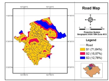
Road map can be presented in Figure 11.
Figure 11 Road suitability map
Figure 11 shows the buffer of road that divided into three classes, namely S1 (71.64%), S2 (15.57%) and S3 (12.78%). Buffer map indicates that the area with yellow color has a range of (0 - 5 km) from the road line (S1), whereas the area in red color has a distance between(5 - 10 km) from the road line (S2), then the area with blue color has a range that exceed 10 km from the road line (S3).
4.1.3.2 Factory Location Map
Factory location is also one of the criteria needed to be considered in the development of oil palm plantations. Factory location close to the plantations would be very beneficial, because transportation fee can be minimized.
Figure 12 Factory location suitability map
Figure 12 shows that the buffer of factory location was divided into three classes, namely S1 (5.78%), S2 (35.25%) and S3 (58.97%). Buffer map indicates that the area with yellow color has a range of (0 - 5 km) from the factory location (S1), whereas the area in red color has a distance between(5 - 10 km) from the factory location (S2), then the area with blue color has a range that exceed 10 km from the factory location (S3).
Figure 13 Access suitability map
Figure 13 shows the access suitability classes in the study area. It showed the class S1 (5.45%), S2 (71.44%) and S3 (23.10%).
4.1.4 Generating Constrains Map 4.1.4.1 Settlement Map
One of constrain factor in the development of plantations based on regulations and government policies is that the area designated as a settlement cannot be converted into plantation areas. Figure 14 shows a map of settlement areas in Musi Banyuasin regency.
Figure 14 Settlement map
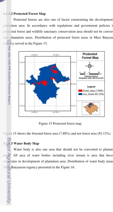
4.1.4.2 Protected Forest Map
Protected forests are also one of factor constraining the development of plantation area. In accordance with regulations and government policies that protected forest and wildlife sanctuary conservation area should not be converted into plantation areas. Distribution of protected forest areas in Musi Banyuasin regency served in the Figure 15.
Figure 15 Protected forest map
Figure 15 shows the forested forest area (7.88%) and not forest area (92.12%).
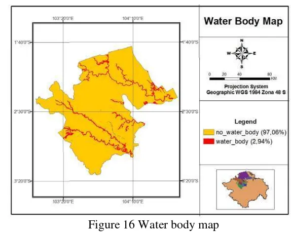
4.1.4.3 Water Body Map
Figure 16 Water body map
Figure 16 shows the water body area in the study area. It showed the water body area (2.94 %) and not water body area (97.06%).
4.1.4.4 Paddy Field Map
Based on the regulations and government policies, zones of paddy field also cannot be converted into plantation areas, areas with a zone of paddy field are also a constraint in the development of plantations. Distribution of paddy field areas in Musi Banyuasin regency served in the Figure 17.
Figure 17 Paddy field map
4.2 Weighting Based on Pairwise Comparison Matrix (PCM)
Pairwise comparison method basically creates a ratio matrix, which takes inputs from experts to produce the relative weights as output (Malczewski, 1999). The weight is produce from normalizing the eigenvector associated with the maximum eigenvalue of the reciprocal ratio matrix.
The questionnaire of the expert group is the main input data for the matrix calculation in determining the weight to each factor and the criteria in determining the location of oil palm plantations. The criteria in determining the location of oil palm plantations, among others: climatic factors, land conditions and accessibility. Results of questionnaires from some experts can be seen in detail in Appendix 1.
4.2.1 Climate Suitability Factor
Climatic factors including rainfall and temperature is one factor that must be considered in determining the location of the plantation. These factors become important due to water requirement in growing oil palm plantations. Plantations would be better if located in areas that have high rainfall and moderate to high temperature. Scale assessment of each criteria and the main eigenvector value (priority) of a combination of several experts to climate factors can be presented in Table 6.
Table 6 Pairwise comparisons matrix on climate factor
Criteria Rainfall Temperature Priority
Rainfall 1 8.3 0.890
Temperature 1/8.3 1 0.110
4.2.2 Land Condition Factor
Land condition factors including soil type, distance from river and slope are physical factors to be considered in the development of plantations. The weight value from the expert helped in conducting spatial analysis. Scale assessment of each criteria and the main eigenvector value (priority) of a combination of experts to land condition factors can be presented in Table 7. Table 7 Pairwise comparisons matrix on land condition factor.
Criteria Soil Type
Distance
from River Slope Priority Soil Type 1 3.45 4.59 0.650 Distc From River 1/3.45 1 2.45 0.230 Slope 1/4.59 1/2.45 1 0.120
Table 7 shows that the criteria for soil type to be the top priority in the development of Plantations with the highest eigenvector 0.650, then followed by the criteria of distance from river 0.230 and the lowest value eigenvector value is the slope with a value 0.120.
4.2.3 Accessibility Factor
Accessibility factor is also considered in the development of plantation. Road distance and location of the factory near the plantation is consideration for accessibility factor. The result of several expert assessments for accessibility factor is shown in Table 8.
Table 8 Pairwise comparisons matrix on accessibility factor
Criteria Distance road Distance factory Priority Distance road 1 0.71 0.420 Distance factory 1/0.71 1 0.580
4.2.4 Suitability of Oil Palm Plantation
Value of the weight given to suitability of palm oil plantation is also one deciding factors in spatial analysis for the development of plantations. The result from several expert assessments for suitability of palm oil plantation factor is shown in Table 9.
Table 9 Pairwise comparisons matrix on suitability of oil palm plantation factor
Criteria Climate Land condition Accessibility Priority Climate 1 1.57 4.58 0.530 Land condition 1/1.57 1 3.55 0.360 Accessibility 1/4.58 1/3.55 1 0.110
Table 9 shows that the criteria for climate to be the top priority in the development of Plantations with the highest eigenvector 0.530, then followed by the criteria of land condition 0.360 and the lowest value eigenvector value is the accessibility with a value 0.110.
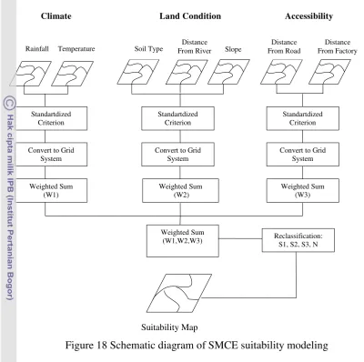
4.3 GIS-Spatial Multi Criteria Evaluation
GIS have capability to store and analyze spatial data effectively, and it could spatial modeling to support decision analysis. GIS has long experience in decision making and map design, and it can integrate with SMCE system to support decision maker’s (Zhao and Garner, 2009). In this research, GIS-SMCE capabilities need to simulate different criteria to making suitability map.
Figure 18 Schematic diagram of SMCE suitability modeling
4.3.1 Suitability Assessment
Suitability analysis for the development of oil palm plantations in Musi Banyuasin regency in this study is based on an assessment of the factors that have a high value on the influence of other factors. It make the three scenarios (alternative) with weighting based on the opinions of expert, local knowledge, and giving value to the weights same for each criteria.
4.3.1.1 Assessment based on expert (Alternative 1)
Based on the expert assessment for the criteria of climate, rainfall is a factor that considered more important than temperature. For the criteria of land conditions, the slope is considered less important than soil type and distance from the river, soil type is considered more important than the distance from the river.
Distance From Factory Rainfall Temperature Soil Type From River Distance Slope
Distance
(W1,W2,W3) Reclassification: S1, S2, S3, N
Suitability Map
For the criteria of accessibility, distance from palm oil factory is considered quite more important than the distance from the road. The weights based on expert assessments shown in Table 10.
Table 10 Weight value based on expert Assessment
Criteria/Sub Criteria Weight Value
Climate 0.530
1. Rainfall 0.890 2. Temperature 0.110 Land Condition 0.360 1. Soil Type 0.650 2. Distance From River 0.230
3. Slope 0.120
Accessibility 0.110 1. Distance From Road 0.420 2. Distance From Factory 0.580
The calculation of the matrix pairwise comparison method for the weight of each criterion would be used as input weighting values in the process model in SMCE module. Input data in ILWIS Module for each factor and constrains based on expert assessment is show in Figure 19.
The results of the analysis process suitability of oil palm plantation using SMCE model in ILWIS module based on expert assessment shown in Figure 20.
Figure 20 Suitability of oil palm based on expert assessment
Figure 20 shows the suitability classes based on expert assessment in the study area that showed the class S1 (29%), S2 (50.41%), S3 (4.98%) and N (15.61%).
4.3.1.2 Assessment Based on Same Weight Value (Alternative 2)
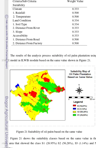
Table 11 Weight based on the same value
Criteria/Sub Criteria Suitability
Weight Value
Climate 0.333
1. Rainfall 0.500
2. Temperature 0.500
Land Condition 0.334
1. Soil Type 0.334
2. Distance From River 0.333
3. Slope 0.333
Accessibility 0.333
1. Distance From Road 0.500 2. Distance From Factory 0.500
The results of the analysis process suitability of oil palm plantation using SMCE model in ILWIS module based on the same value shown in Figure 21.
Figure 21 Suitability of oil palm based on the same value
4.3.1.3 Assessment Based on Local Knowledge (Alternative 3)
Assessment based on local knowledge is one scenario weighting that obtained from the local communities in the study area which makes the assumption that for the criteria accessibility is a factor that considered more important than land condition and climate. Accessibility factor has a weighting value is higher because distance of plantation that near with the road and plant site will minimize the amount of transportation costs. Weights based on local knowledge are shown in Table 12.
Table 12 Weight value based on local knowledge
Criteria/Sub Criteria
Suitability Weight Value
Climate 0.200
1. Rainfall 0.500
2. Temperature 0.500 Land Condition 0.300
1. Soil Type 0.334
2. Distance From River 0.333
3. Slope 0.333
Accessibility 0.500 1. Distance From Road 0.500 2. Distance From Factory 0.500
Figure 22 Suitability of oil palm based on local knowledge.
Figure 22 shows the suitability classes based on local knowledge in the study area that showed the class S1 (21.45%) S2 (60.38%), S3 (2.53%) and N (15.61%).
4.3.2 Alternative Comparison for Final Selection
The composite index maps can be compared to each other in several ways, in order to rank-order the sites. The most common way is to aggregate the composite indexes of each site through their histogram values (e.g., maximum, average, sum, and connectivity index) and rank-order the sites accordingly. The one with the most favorable selected histogram value becomes the site recommended by the SMCE process.
Figure 23 shows the histogram for alternative comparison.
Figure 23 Histogram of alternative comparison
Table 13 Suitability area comparison
Suitability Area (Ha)
Alternative1 Alternative2 Alternative3
Highly Suitable (S1) Grand Total 1,444,039.1 1,444,039.1 1,444,039.1
4.4 Comparison Map of Suitability with Existing Oil Palm Plantations
Map of results for the spatial overlay of generated suitability map of oil palm and existing plantations can be seen in Figure 24. (Appendix 4). It can be seen that existing plantation situated in all types of suitability classes (S1, S2 and S3). It seems that the existing plantations do not follow pattern of classes in the field. Some plantations are situated at S2 and S3 classes, although S1 class is still available. But there is a general pattern, that all existing plantation are situated follow river and road infrastructure.
Figure 24 Map of oil palm suitability and existing plantation
Table 14 Area and percentage of suitability and existing oil palm plantation
Suitability Class
Area
Ha Percentage Not Suitable (N) 225,500.0 15,61 Highly Suitable (S1) 306,612.42 21,23 Suitable (S2) 622,157.41 43,08 Moderate Suitable (S3) 66,079.53 4,57 Existing Plantation 223,699.66 15,49
4.5 Development Area of Oil Palm Plantation
Based on the results overlay process of suitability map with administrative boundaries indicates that the suitability classes (S1) which has the potential for oil palm development in Musi Banyuasin regency are in some region. Figure 25 shows the distribution area of suitability class in each district area.
Table 15 Development plantation area
Sub District Development Plantation Area Ha Percentage Sungai Lilin 62,246.37 20.30 Sungai Keruh 9,622.26 3.13
Sekayu 56,466.3 18.4
Plakat Tinggi 1,987.58 0.64
Lais 45,198.52 14.74
Keluang 33,312.03 10.86 Batang Hari Leko 360,18 0.11 Babat Toman 5,386.06 1.75 Bayung Lalan 33,475.37 10.91 Bayung Lencir 58,558.68 19.10 Grand Total 306,612.42 100
V. CONCLUSIONS AND RECOMMENDATIONS
5.1. Conclusions
• Geographic Information System (GIS) analysis using Spatial Multi Criteria Evaluation (SMCE) in finding the best location for oil palm plantation succeeded to choose Sungai Lilin Sub-District as the best location for oil palm development. Sungai Lilin Sub-District has the total suitability area of 62,246.37 Ha or 20.30% of Musi Banyuasin regency area.
• Based on the calculation area and percentage of suitability map and existing oil palm plantation indicated that area Highly Suitable (S1) for development plantation area is 306,612.42 ha or 21,23% of Musi Banyuasin regency and for the existing plantation area is 223,699.66 ha or 15,49%. Existing plantation do not follow exactly generated suitability classes, most of them situated nearby road and river. Therefore road and river must be given higher weighting criteria for suitability classification.
5.2. Recommendation
• Information about land suitability area can be used by local government in making a map of spatial plans and for the investors or farmers to determine which areas could be suitable for oil palm plantation.
• Productivity of existing plantation in S1, S2 and S3 class should be compared based on fresh bunches fruit data in the field.
REFERENCES
[BPS] Badan Pusat Statistik. 2010. Hasil Sensus Penduduk 2010 Kabupaten Musi Banyuasin: Data Agregat per kecamatan.
Burrough PA. 1986. Principles of Geographic Information System for Land resources Assessment. Oxford. Oxford University Press.
[CIFOR] Center for International Forestry Research. 1999. Guidelines for Applying Multi-Criteria Analysis to the Assessment of Criteria and Indicators. Jakarta; CIFOR
De la Rosa D. 2000. Conceptual Framework Agro-ecological Land Evaluation. Institudo de Recursos Naturales y Agrobiologia, CSIC, Avda. Reina Mercedes 10,41010 Sevilla,Spain.Available :
[FAO] Food and Agriculture Organization. 1976. A Framework for land Evaluation. Available:
[GAPKI] Indonesian Palm Oil Associati
Available
Government of Musi Banyuasin Regency 2010. Profil Kabupaten Musi Banyuasin.
Guerin, B. 2006. ‘Jakarta eyes palm oil for fuel’ Asia Times Online.
Handoko, I. 1994. Basic Construction and Application of Computer Simulation Models in Agriculture, department of Meteorology and Geophysics, Faculty of Mathemathics and Natural Science, Bogor Agricultural Unyversity.
Hardjowigeno,S. Widiatmaka. 2001. Kesesuaian Lahan dan Perencanaan Tataguna Tanah. Bogor.
ILWIS User’s Guide .2004 :
M. A. Shari_ and H. van Keulen,1994. A decision support system for land use planning", Agricult. Syst., vol. 45, pp. 239-257.
M. A. Shari_ and M. van Herwijnen. 2003 Spatial Decision Support System: Theory and Practice. Enschede: ITC Lecture Serie.
Malczewski J. 1999. GIS and Multicriteria Decision Analysis. John Wiley & Sons. USA and Canada
Marinoni, O. 2004. Implementation of the analytical hierarchy process with VBA in ArcGIS. Computers & Geoscience 30 (2004) 637-646
Marimin. 2008. Pengambilan Keputusan Kriteria Majemuk. Jakarta: Grasindo. Saaty, L.T. 1988. Decision Making for Leaders: The Analytical Hierarchy
Process for Decisions in a Complex World. Pittsburg: University of Pittsburg.
Turban E. and Jay E. Aronson. 2001. Decision Support Systems and Intelligence Systems, 6th Edition. New Jersey .Prentice Hall, Upper Saddle River. Zhao, L. and B. J. Garner. 2001. Developing GIS Tools to Integrate MCDM for
Appendix 1: input Pairwise Comparison Matrix (PCM) of all criteria 1. Respondents 1
Criteria Rainfall Temperature Priority
Rainfall 1 5 0.834
Criteria Distance road Distance factory Priority Distance road 1 1/3 0.25 Distance factory 3 1 0.75 CR = 0.000
Criteria Climate Land condition Accessibility Priority
Climate 1 5 7 0.723
Land condition 1/5 1 3 0.193 Accessibility 1/7 1/3 1 0.084 CR = 0.0568
2. Respondents 2
Criteria Rainfall Temperature Priority
Rainfall 1 7 0.875
from River Slope Priority
Soil Type 1 3 5 0.634
Distance From River 1/3 1 3 0.260
Slope 1/5 1/3 1 0.106
CR =0.03338
Criteria Climate Land condition Accessibility Priority
Criteria Rainfall Temperature Priority
Rainfall 1 3 0.75
Temperature 1/3 1 0.25 CR = 0.000
Criteria Soil Type
Distance
from River Slope Priority
Soil Type 1 3 5 0.648
Distance From River 1/3 1 2 0.230
Slope 1/5 1/2 1 0.122
CR = 0.0318
Criteria Distance road Distance factory Priority
Distance road 1 4 0.8
Distance factory 1/4 1 0.2 CR = 0.000
Criteria Climate Land condition Accessibility Priority
Climate 1 1 3 0.428
Land condition 1 1 3 0.428 Accessibility 1/3 1/3 1 0.144 CR = 0.000
4. Respondents 4
Criteria Rainfall Temperature Priority
Rainfall 1 7 0.875
Temperature 1/7 1 0.125 CR = 0.000
Criteria Soil Type
Distance
from River Slope Priority
Soil Type 1 3 5 0.634
Distance From River 1/3 1 3 0.260
Slope 1/5 1/3 1 0.106
Criteria Distance road Distance factory Priority
Condition Accessibility Priority
Climate 1 1 3 0.4054
Land condition 1 1 5 0.4796 Accessibility 1/3 1/5 1 0.1150 CR = 0.0251
5. Respondents 5
Criteria Rainfall Temperature Priority
Rainfall 1 7 0.875
Temperature 1/7 1 0.125 CR = 0.000
Criteria Soil Type
Distance
from River Slope Priority
Soil Type 1 3 5 0.634
Distance From River 1/3 1 3 0.260
Slope 1/5 1/3 1 0.106
CR = 0.0333
Criteria Distance road Distance factory Priority Distance road 1 1/8 0.111 Distance factory 8 1 0.889 CR = 0.000
Criteria Climate Land condition Accessibility Priority
Climate 1 1 3 0.405
Land condition 1 1 5 0.480 Accessibility 1/3 1/5 1 0.115 CR = 0.0251
6. Respondents 6
Criteria Rainfall Temperature Priority
Rainfall 1 8 0.889
Criteria Soil Type
Distance
from River Slope
Priority
Soil Type 1 3 5 0.619
Distance From River 1/3 1 4 0.284
Slope 1/5 1/4 1 0.097
CR = 0.0747
Criteria Distance road Distance factory Priority
Distance road 1 4 0.8
Distance factory 1/4 1 0.2 CR = 0.000
Criteria Climate Land condition Accessibility Priority
Climate 1 3 7 0.668
Appendix 2: Geometric Mean of Input PCM for All Criteria
Criteria Rainfall Temp Priority
Rainfall 1 8.3 0.890
Temp 1/8.3 1 0.110
CR = 0.000
Criteria Soil Type
Distance
from River Slope Priority Soil Type 1 3.45 4.59 0.650 Distc From River 1/3.45 1 2.45 0.230 Slope 1/4.59 1/2.45 1 0.120 CR = 0.0360
Criteria Distance road Distance factory Priority Distance road 1 0.71 0.420 Distance factory 1/0.71 1 0.580 CR = 0.000
Appendix 3 : ILWIS Step in Spatial Multi-Criteria Evaluation (SMCE)
(ILWIS 3.4, 2010;
START
Identification of the main Goal
Identification of a hierarchy of sub goals
Identification of criteria or effects,
which measure the performance of the sub goals
Creating and filling a criteria tree, which represents the hierarchy of the main goal,
any sub goals, and the criteria.
Assignment of input maps to criteria for each alternative Identification of alternatives to be evaluated
Determination of a standardization method per criterion
Weighing of criteria in the criteria tree
Calculation of the Composite Index maps and visualization
Inspecting the values in the Composite Index maps
Classifying or slicing the Composite Index maps
Calculation of Shape Index
Appendix 4. Suitability map of oil palm plantation in Musi Banyuasin regency
a) Map of Musi Banyuasin Regency
55
YUDI ASTONI. Determining Oil Palm Plantation Potential Location Using Spatial Multi-Criteria Evaluation (Case Study in Musi Banyuasin Regency, South Sumatra Province). Under the Supervision of SURIA DARMA TARIGAN and HARTANTO SANJAYA
Indonesia has the potential land to grow oil palm plantation and currently being the largest producer of crude palm oil (CPO). Satellite remote sensing data is very potential to be used in studies of forest conditions and plantation, because remote sensing data gives current and accurate information. Sumatra Island, especially Musi Banyuasin regency is one of area that has potential for oil palm plantation development. The objective of this research is to determine the potential location of oil palm plantation development by considering bio-physical criteria such as climate suitability, land condition, and accessibility in Musi Banyuasin regency, and to evaluate the suitability map of oil palm plantation that obtained compared with existing plantation in Musi Banyuasin regency. The Method of this research is based on multi criteria decision making by implementing GIS model technology using spatial multi criteria evaluation that will determine location of oil palm plantation potential. Each criterion and alternatives should be evaluated and weighted using pairwise comparison method to determine the best location for oil palm plantation potential in Musi Banyuasin Regency. Geographic Information System (GIS) analysis using Spatial Multi Criteria Evaluation (SMCE) in finding the best location for oil palm plantation succeeded to choose Sungai Lilin Sub-District as the best location for oil palm plantation development. Sungai Lilin Sub-District has the total suitability area of 62,246.37 Ha or 20.30% of Musi Banyuasin area. Based on the calculation area and percentage of suitability map and existing oil palm plantation indicated that area Highly Suitable (S1) for development plantation area is 306,612.42 ha or 21.23% of Musi Banyuasin regency and for the existing plantation area is 223,699.66 ha or 15.49%.
1.1 Background
A significant change in the oil palm industry has taken place during the past season, as Indonesia surpassed Malaysia in production of palm oil and is now the world leader. Indonesia has become the first largest world producer of crude palm oil (CPO) followed by Malaysia (GAPKI, 2006). Together these two countries account for 84% of total world production and 88% of global exports (Guerin, 2006). The demand for oil palm significantly increased both local and export, so that land clearing for plantation in Sumatra and Kalimantan regions expanded.
Satellite remote sensing data is very potential to be used in studies of forest conditions and plantation, because remote sensing data gives current and accurate information. Sumatra Island, especially Musi Banyuasin regency is one of area that has potential for oil palm plantation development. Suitability for plant cultivation need to be considered in order to obtain optimal growth, although the plants seem to grow together in a region, but each type of plant has a character that requires different requirements, so that optimum production can be observed among the suitability of land for farming and growing requirements for each type of plant.
Potential land for plantation development basically determined by the physical properties and the environment which include: soil, topography, hydrology and climate. Suitability between the physical properties with the requirements of the use of a commodity to be evaluated will give an idea or information that the land has potential for the development of these commodities. This means that if the land is used for a specific use by providing the necessary input it will give results as expected.
1.2 Problem Statement
Musi Banyuasin regency has large potential area for the development of oil palm plantations. With this condition, the main problem in this research is: "where are optimal locations (priority) for oil palm development by considering the criteria for climate suitability, land condition, and accessibility using Geographic Information System (GIS) technology?”
1.3 Research Objectives
The objectives of this research are:
1. To determine the potential location of oil palm plantation development by considering bio physical criteria such as climate suitability, land condition, and accessibility in Musi Banyuasin regency.
2. To evaluate the generated suitability map of oil palm plantation with existing plantation in Musi Banyuasin regency.
1.4 Research Scope
This research is intended to search for the potential areas which can be exploited for oil palm plantation development in Musi Banyuasin regency. In this research, land suitability analysis for oil palm plantation development will be carried out using GIS with processing spatial data such as intersect and buffer processing for a few maps and Spatial Multi-Criteria Evaluation (SMCE) technique and used pairwise method as significant tool in decision making.