MONITORING SEASONAL PROGRESS OF RICE STUBBLE BURNING IN MAJOR RICE
GROWING DISTRICTS OF HARYANA, INDIA, USING MULTIDATE AWiFS DATA
Manoj Yadav*, R. Prawasi, Satyawan Jangra, Pooja Rana, Kiran Kumari, Shyam Lal, K. Jakhar, S. Sharma and R. S. Hooda
Haryana Space Applications Centre (HARSAC), C.C.S.H.A.U. Campus, Hisar- 125004, India
Email: [email protected]
Commission VI, WG VI/4
KEY WORDS: AWiFS, Rice Stubble, Burning, NDVI
ABSTRACT:
The present paper describes the methodology and results of assessment of seasonal progress of rice stubble burning for 10 major rice growing districts of Haryana state in India. These 10 districts contribute about 84 per cent of total rice area of the state. As the rice fields are immediately required to be vacated for the sowing of next crop the farmers opt for mechanized harvesting and easy way out of burning the stubbles in the field. Such burning result in release of polluting gases and aerosols. Besides, the heating of the soil kills the useful micro-flora of the soil causing soil degradation. Multi-date AWiFS data from Resourcesat 1 and 2 satellites acquiredbetween October 16, 2013 to November 26, 2013 were used for estimating paddy stubble burning areas at different intervals for the year 2013 crop growing season. In season collected ground truth data using hand held GPS along with field photographs were used to identify paddy stubble burning areas and other land features. Complete enumeration approach and Iterative Self-organizing Data Analysis Technique (ISODATA) unsupervised classifier was used for digital analysis. Normalized Difference Vegetation Index (NDVI) of each date was also used with other spectral bands of temporal images. To improve the classification accuracy the non-agricultural areas were masked out. The area was estimated by computing pixels under the classified image mask. Progress of paddy stubble burning was estimated at different intervals for the year 2013 using available cloud free multi-date IRS-P6 AWiFS data to identify the crucial period when stubbles burning takes place in major area so that preventive measures can be taken to curb the menace.
1. INTRODUCTION
The burning of crop residues in fields is one of the most significant activities of global biomass burning (excluding biofuels; Streets et. al., 2003), and contributes substantially to air pollution. This is particularly true for the treatment of rice straw in Asian countries, where more than 1.2 million km2 of land is used
to grow rice, accounting for 60% of rice production worldwide. After harvesting, the waste rice straw is frequently burned in the open in regions with insufficient time before planting the next crop to remove and dispose of it in a more controlled manner, such as in a furnace or by using another closed burning technique (Calvo et. al., 2011). Almost 90-95% of Paddy area in Punjab, Haryana and Western UP is under intensive Rice-Wheat-System (RWS) Ladha, et. al., 2000). RWS in Haryana is mostly concentrated in the north-eastern and north-western part of Yamuna and Ghaggar flood plains occupying 9.16 lac hectares, which is 24.75% of the total agricultural area of the state (Panigrahy et. al., 2008). Mechanized combine harvesting technologies, which have become common in RWS in India, leave behind large quantities of straw in the field for open burning of residue. The burning of rice residue emits GHG emissions as carbon dioxide (CO2), methane (CH4), and nitrous oxide (N2O), pollutants as carbon monoxide (CO), particulate matter (PM), and toxic as polycyclic aromatic hydrocarbons (PAHs) due to the incomplete combustion process (P.M. Lemieux et. al., 2004and F. Duan et. al., 2004).The emissions of CH4, CO, N2O, and NOx
have been estimated to be about 110, 2306, 2 and 84 Gg respectively, from rice and wheat straw burning in India in the
growing districts of Haryana was attempted by Yadav et. al., (2013 & 2014) using multi-date AWiFS sensor data of Indian satellites. Crop residue discrimination over agricultural fields of Moga and Naraingarh areas of Punjab state of India was attempted by Singh et. al., (2013) using ground- based hyper spectral data. The present study has been attempted for area estimation of paddy stubble burning in ten major paddy growing districts of Haryana, India using multi-date Resourcesat-1 and 2 AWiFS data of Indian Remote Sensing Satellite for the year 2013.
2.
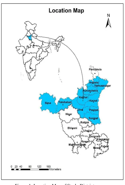
METHODOLOGY 2.1 Study AreaTen project districts namely Ambala, Fatehabad, Jind, Kaithal, Karnal, Kurukshetra, Panipat, Sirsa, Sonipat, and Yamunanagar situated between 28045’ to 30035’ N latitudes and 74025’ to
77040’E longitudes, were selected for the study as they contribute
more then 84%) of the paddy stubble burning areas in the state (Figure 1). The geographical area of these ten districts is 1574, 2538, 2702, 2317, 2520, 1530,1268, 4277, 2122 and 1768 sq. km. respectively. The project districts have a sub-tropical continental monsoon climate with hot summer and cool winter. The average annual rainfall of districts for the four years 2007-2010 varied between 267 mm in Western district Sirsa to 964 mm in most northern district Yamunanagar (State Statistical Abstract of Haryana, 2013). For all the districts wheat is the dominating/major crop during rabi season and paddy is the dominating/major crop during kharif season.
2.2 Data Used 2.2.1 Satellite Data
Satellite, sensor and acquisition dates for the data used during analysis are given in Table 1.
Crop of
Study
Satellte &
Sensor
Acquisition
Date of
Paddy Resourcesat- along with the field photographs, twice during second fortnight of October and first fortnight of November, 2013.This ground truth information was used for the identification of the stubble burnt areas of rice, associated crops and land features during digital classification of satellite data.
2.3 Digital Data Analysis
Digital image analysis was carried out using Geomatica, ERDAS Imagine and ArcGIS software packages using complete enumeration approach. Details of the steps involved in digital analysis are described elsewhere (Anonymous, 1990 and Patel et
al., 1993, Yadav et. al., 2008, Hooda et. al., 2008, Yadav et.al., 2014.
Figure 1. Location Map of Study Districts
This Geo-tiff image data was imported to image format using ERDAS Imagine software package and later on exported to pix format using Geomatica software package. The temporal images prepared were used for digital analysis using complete enumeration approach. In complete enumeration approach the administrative boundary of the project districts were superimposed on the geo-referenced image and all the data elements (pixels) within this were extracted for further classification etc. (Figures 2). Such a procedure has been successfully used for wheat (Dadhwal and Parihar, 1985), (Kalubarme et. al., 2004), rice (Kalubarme & Vyas, 1990), Oilseeds (Sharma et.al., 1991), Sugarcane (Saroha et.al.,1999), for Saanthi Paddy (Hooda et.al, 2008) and for Burning wheat/paddy stubble (Yadav et. al., 2013 & 14) in the past. Normalized Difference Vegetation Index (NDVI) was computed for each date of satellite data and used during analysis along with spectral bands. NDVI was scaled up by multiplying with 100 and adding 100 to obtain range from 0 to 200 (Panigrahy et. al., 2004).To round off the NDVI values 0.50 was added. The NDVI was computed as follows:
NDVI = NIR – R / NIR + R * 100 + 100+ 0.5
stubble from associated land features. A combined mask was prepared from multi phased classified images. The area of the mask out images was classified and per cent burnt stubbles area was computed.
Figure 2. Procedure for AOI extraction and preparation of Non-agricultural mask
3.
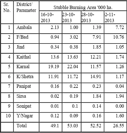
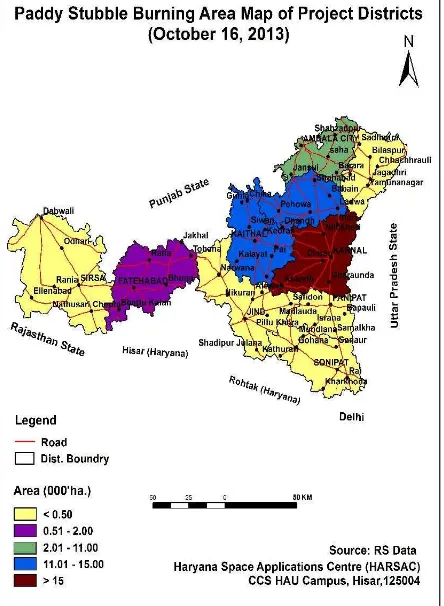
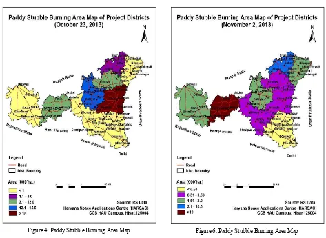
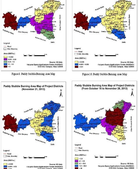
RESULTS AND DISCUSSIONSSowing/planting of paddy in Haryana takes place during June to July and harvested during from first fortnight of October to first fortnight of November. As the fields are immediately required for the sowing of next crop the farmers have easy way out to go for burning of stubble in the field. District wise paddy stubble burning area of the districts at different intervals for the year 2013 are given in Table 2, 3 and Spatial distribution of paddy stubble area is depicted in Figures 3 to 10.
Total paddy stubble burning area in the ten project districts during the study period from October 16 to November 26, 2013 was observed to be 208.34 thousand hectares which is 20.29% of the total paddy cropped area in these districts Study indicates that (19.61 th. ha.) and Ambala (12.27 th. ha.) districts while in Jind (4.17 th. ha.),Yamunanagar (1.98 th. ha.), Sonipat (1.23 th. ha.) and Panipat (0.81 th. ha.) districts very less paddy stubble burning area was observed (Table 4 and Figure 11).
In project districts paddy stubble burning area was recorded (49.04 th. ha.) on October 16 and reached at the peak on October 23 (53.03 th. ha.) and afterwards sowing decreasing trend and reached at negligible level on November 26, 2013 (Table 2 and 3). Study indicates that early harvesting and burning of paddy stubble takes place in northern districts namely Kaithal, Karnal, Kurukshetra one central district Jind and eastern districts Panipat and Sonipat during second week of October. Harvesting and burning of paddy stubble takes place during first week of November in Northern districts Ambala, Yamunanagar and central district Fatehabad. Late harvesting and burning takes place in Sirsa district during 3rd week of November (Figure 3 to 10).
Sr.
Table 2. Paddy Stubble Burning Area In Districts of Haryana at Different Intervals Table 3. Paddy Stubble Burning Area In Districts of Haryana at Different Intervals
Sr.
Table 4. Paddy Stubble Burning Area In Districts of Haryana for Total Study Period
*Department of Agriculture, Haryana
4.
CONCLUSIONS
It was observed that in season multi-date LISS-3 data is useful for the acreage estimation of burnt paddy stubble at district level. In the present study due to non availability of multi-date cloud free LISS-III digital data, in season multi-date AWiFS data was were used. The data were found to be useful due to its better temporal resolution. Resourcesat 1 & 2 AWiFS with short wave infra-wave along with NDVI of all dates provided separability of paddy stubble burnt areas. For a small state like Haryana complete enumeration approach is useful to improve accuracy along with masks of non agricultural classes such as water bodies, settlement, forest, plantation and wastelands etc. In season temporal AWiFS data between October 16, 2013 to November 26, 2013 are found to be useful for the study.
Total paddy stubble burnt area in the ten project districts was observed to be 208.34 thousand hectares. Study indicates that extent of burnt paddy stubble area is more in three northern districts of Karnal (54.33 th. ha.), Kaithal (41.42 th. ha.), Kurukshetra (39.82 th. ha.), and one western district i.e. Fatehabad (32.68 th. ha.), moderate in Sirsa (19.61 th. ha.) and Ambala (12.27 th. ha.) districts while in Jind (4.17 th. ha.), Yamunanagar (1.98 th. ha.), Sonipat (1.23 th. ha.) and Panipat (0.81 th. ha.) districts very less paddy stubbles burning was observed. Low paddy stubble burning in Jind, Yamunanagar, Sonipat and Panipat districts may be due to manual harvesting and low land holding.
In project districts paddy stubble burning area was recorded (49.04 th. ha.) on October 16 and reached at the peak on October 23 (53.03 th. ha.) and afterwards sowing decreasing trend and reached at negligible level on November 26, 2013. Study indicates that early harvesting and burning of paddy stubble takes place in northern districts namely Kaithal, Karnal, Kurukshetra one central
district Jind and eastern districts Panipat and Sonipat during second week of October. Harvesting and burning of paddy stubble takes place during first week of November in Northern districts Ambala, Yamunanagar and central district Fatehabad. Late harvesting and burning takes place in Sirsa district during 3rd
week of November.
As the satellite data of paddy harvesting season are not available between October 01 to 14 and November 02 to 11, 2013 due to cloudy conditions, it may be possible that the burnt area of the period may be resown for rabi crops and not picked on the satellite images of the later date. Consequently there could be little under estimation in paddy stubbles burnt area progress of paddy stubble burning takes place during the period was not monitored. More frequent satellite data availability is required for such studies. Regular monitoring of paddy stubble burning area using satellite data is required for controlling the menace of crop stubble burning in open fields and to monitor the effect of campaign against the dangerous practice.
ACKNOWLEDGEMENTS
Authors are thankful to Haryana State Pollution Control Board (HSPCB), Panchkula, Haryana for taking keen interest and providing financial assistance for the project. We would like to place on records the heartfelt thanks to Agriculture Department, Haryana for providing crop related information and for extending all possible help during ground truth collection. Help provided by other staff members of HARSAC is also thankfully acknowledged.
Figure 4. Paddy Stubble Burning Area Map
Figure 5. Paddy Stubble Burning Area Map
Figure 6. Paddy Stubble Burning Area Map
Figure 8. Paddy Stubble Burning Area Map
Figure 9. Paddy Stubble Burning Area Map
Figure 10. Paddy Stubble Burning Area Map
REFERENCES
Anonymous., 1990. Steps in digital image analysis for crop acreage estimation at regional remote sensing service centers, Status report on crop acreage and production estimation, RSAM/SAC/CAPE/SR/25/90, p.239.
Badarinath, K.V.S., T. R. Kiranchand and Krishna Prasad, V., 2006. Agriculture crop residue burning in ht Indo-Gangetic Plains – A study using IRS-P6 AWiFS satellite data. Current Science 91(8), pp. 1085-1089.
Calvo, A. I., Castro, A., Pont, V., Cuetos, M. J., M. E. Sanchez and Fraile, R., 2011. Aerosol Size Distribution and Gaseous Products from the Oven-controlled Combustion of Straw Materials. Aerosol Air Qual. Res. 11, pp. 616–629.
Dadhwal, V. K. and Parihar, J. S., 1985. Estimation of 1983-84 wheat acreage of Karnal district (Haryana) using Landsat MSS digital data. Scientific Note: IRS-UP/SAC/CPF/SN/09/85. Duan, F., Liu, X., T. Yu and Cachier, H., 2004. Identification and estimate of biomass burning contribution to the urban aerosal organic carbon concentrations in Beijing,” Atmospheric Environment 38, pp. 1275- 1282.
Gupta, P. K., Sahai, S., Singh, N., Dixit, C. K., Singh, D. P., Sharma, C., Tiwari, M. K., R. K. Gupta and Garg, S.C., 2004. Residue burning in rice-wheat cropping system: Causes and implications. Current Science 87(12), pp. 1713-1717.
Hooda, R. S., Yadav, M. Sharma, M. P. and Prawasi, R., 2008. Estimation of summer paddy in Haryana (India) using high resolution satellite data. Proc. of International Workshop on Earth Observation & Remote Sensing Applications, China, January 22-25, 2008.
Kalubarme, M. H. and Vyas, S. P., 1990. Remote sensing based rice acreage estimation in Midnapore district (West Bengal). Status Report on CAPE, RSAM/SAC/CAPE/SR/25/90, 178-188 pp.
Kalubarme, M. H., Sharma Alka, Sood R. K., Thapa R., Deol S. S., Negi Kalpana, Sharma Priyanka and Ghabru, S. K., 2004. Wheat production forecast in Himachal Pradesh. Scientific Note: RSAM/SAC/CAPE-II/SN/93/2004.
Ladha, J. K., Fischer, K. S., Hossain, M., P. R. Hobbs and Hardy, B., 2000. Improving the productivity and sustainability of rice– wheat systems of the Indo-Gangetic plains: A synthesis of NARS– IRRI partnership research. IRRI Discussion Paper Ser. 40, IRRI, Los Banos, Philippines.
Panigrahy, R. K., Ray, S. S. and Panigrahy, S., 2004. Utility of SWIR band for crop discrimination & classification using single date and Multidate IRS-P6 AWiFS data. Scientific Report: Mohanty, R., 1993. Rice production forecasting for Orissa during 1992-93 kharif season using remote sensing data. Scientific Note : RSAM/SAC/CAPE-II/SN/15/93.
Lemieux, P.M., C. C. Lutes and Santoianni, D. A., 2004. Emissions of organicair toxics from open burning: a comprehensive review, Progress in Energy and Combustion Science 30(1), pp.1-32.
Sharma, S, A., Bhatt, H. P., Ajai and Nanavaty, S., 1991. Rapeseed Mustard acreage estimation using IRS LISS-II data. Photonirvachak 19(1), pp. 59-65.
Singh, G., Y. Kant and Dadhwal, V. K., 2009. Remote sensing of crop residue burning in Punjab (India): A study on burned area estimation using mulyi-sensor approach. Geocarto International 24 (4), pp. 273-292.
Statistical Abstract, Haryana 2011-12., 2013. Published by Economic & Statistical Advisor, Planning Department, Govt. of Haryana, pp 563.
Streets, D. G., Yarber, K.F., J. H. Woo, and Carmichael, G. R., 2003. Biomass Burning in Asia: Annual and Seasonal Estimates and Atmospheric Emissions. Global Biogeochem. Cycles17, pp. 1099–1119.
Saroha, G. P.,Yadav Manoj, Sharma M. P. and Singh, A., 1999. Sugarcane acreage estimation and monitoring using remote sensing and GIS techniques. Technical Report : HARSAC/TR/13/1999.
Yadav Manoj., Sharma, M. P., Prawasi, R., S. K. Sharma and Hooda, R. S., 2008. Monitoring area under santhi (summer) paddy in Haryana using high resolution satellite data. Bull. of the National Natural Resources Management System (NNRMS) 32, pp. 15-21.
Yadav Manoj., Sharma, M. P., Prawasi, R., Rajeev, Kumar Pawan, Mandal, V. P., Abdul Salim and Hooda R. S., 2014. Estimation of wheat/rice residue burning areas in major districts of Haryana, India using remote sensing data. J. Indian Soc. of Remote Sensing 42 (2), pp. 343-352.