ANNEX 15:
New challenges and opportunity related to
forest tenure, land allocation and titling in Lao
PDR
By: CHANTHAVIPHONE INTHVONG,
ADG LNRRIC, MoNRE
Policy Development Related to Land &
Forest
•
1986: New Econmic Mechanism => Encourange
Diversified Economic Entities => Privatizing & Lease
out of State Properties (including land);
•
1986: Selfsufficient economy => Commercial
economy => Commodities Production Program
(Prog.I);
•
1989: Forest Conservation & Environment
Protection=> Shifting Cultivation Stabilization
Program (Prog. II);
•
1989: Introduction of National Land Titling & Issuing
Key elements of the Agri-Forest Land
Policy:
•
Abolishing the Cooperative Farming System =>
Reallocation/distribution of production means
(including land) back to Private/HH management;
•
Land Use Zoning and Allocation (Differentiation of
forest land vs agricultural land use and conservation
vs production land uses);
•
New Land Tenure Arrangement (Transfer of
Management Responsibility of State Forest Land to
Community and Private/HH’s responsibility through
long-term lease agreement);
Ceiling Policy for Agricultural Land :
Criteria for allocation to Community (forest &
agricultural land): Varied, depending on local
situation, needs, management tradition &
other policies;
Criteria for allocation to HH: HH’s Labor
–
Paddy Rice: 1 ha per Labor
–
Upland Annual Crop: 3 ha per Labor
–
Upland Tree Crop: 15 ha per Labor
LUPLA & Shifting Cultivation
Stabilization Program:
Shifting Cultivation Stabilization Policy and
Measures
Push for elimination of swidden agriculture for
development through:
»
LUP/LA
(2/3 of total no of Villages),»
Rural Development
»
FDI/Land concessions
7 LNRRIC/NLMA 2010 August
Issues of LUP/LA
Generally participation of the villagers in the LUP/LA exercise was very low due to time limitation and education;
Village land use maps, regulations, data on land titles etc. was lost / not available at DAFO or LMA
The villagers did not really know if their temporary land use certificate was still valid or how to obtain an actual land title (no follow-up after 3 year validity)
LUP/LA arrangements were largely obsolete due to population increase and land concessions
Only temporary land use certificates have been issued so far (only 1 permanent land title in the sample) which are all invalid by now.
Impact of LUP/LA
•
the effects and impacts have shown that several of
the expected results have generally not been
achieved
Increase of protected forest
•
Increase of tenure security (only temporary land use
certificates)
•
Decrease of land conflicts
•
Decrease of agricultural area and
food production
•
Decrease of available NTFPs and wildlife
•
Generally limited impact due to lack of follow-up
9 LNRRIC/NLMA 2010 August
Issues of land concessions/Plantations
-Government’s Policy
- The Lao economy shall be market driven (new mechanism)
- Tree planting is a priority
- Private investment shall be the driving force
-Major Concerns/Issues
• Farmers food security & socio-economic development • Appropriate legislation
Can plantations assist in eradication of poverty?
Yes, if governed properly
Agroforestry contributes to food security
- Labour opportunity (daily labour)
- Employment opportunity (permanent)
- Land lease fees to villagers
- Profit sharing should be consider
- Cottage industries around plantations should be promoted
-Private companies shall be the engine and ensure markets (already on planning stage) - Private companies shall work for food security and socio-economic development of rural communities
- Private companies shall undertake outgrowing schemes when not presenting a financial risk to the farmer
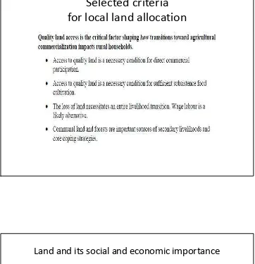
Selected criteria
for local land allocation
Land and its social and economic importance
• Physical space Economic resources
• •
• Food and Land
• shelter markets
• •
• Cultural heritage Rights and obligations
•
• Figure I. Perspectives on land
15
Laos: Abundance of Natural Biodiversity Resources
LNRRIC/NLMA 2010 August
MOSAIC LANDUSE: POROUS FOREST LAND
23
Land Use & NRM:
Issues and Challenges
• How to generate optimum if not maximum wealth from the country’s land & resources to the country and its population;
• increasing investment from FDI in Laos has posed unprecedented
challenges to national land resources utilization, environmental protection and market-oriented land management;
• Existence of large number of land development and concession projects without prior national-wide LU planning & Land titling lead to increasing losing of access to land by rural population;
• Limited law enforcement and governance capacity at local levels (especially at District and Village levels) for Land & Resource sector analysis and policy formulation, implementation and feedbacks; Lead to increasing social conflict and disparity and environmental degradation and occurrence of natural disasters.
LNRRIC/NLMA 2010 August
Land Mangement: Functions
• The main functions in land management are as follows: • 1. Land data survey and allocation;
• 2. General land mapping;
• 3. Land measurement and land quality evaluation; • 4. Classification of land regions;
• 5. Classification of land categories; • 6. Preparation of Land Master Plan; • 7. Land use planning;
• 8. Approval of Land use plan; • 9. Land records (statistics); • 10. Holding land registration book; • 11. Land valuation;
• 12. Assignment of land use right; • 13. Issuance of Land Title; • 14. Land transfer, land lease; • 15. Land uses control;
• 16. Land withdrawal or requisition; • 17. Settlement of land dispute.
25
Priority Activities
In the Land & NRM Sector
• Increase awareness and recognition that land and natural resources are the fundamentals for increasing food security, reducing rural poverty and for assuring sustainable nation-wide prosperity,
• Determine land needs of different sectors and society to meet national development objectives
• National-Wide Macro- and Micro Land Use Zoning Plans • National-wide Land Use (State, Communal & Private) Right
Registration Campaign
• Decentralization of Land Administration and Management Activities (to District &Village Levels)
• Establishment of a (Computerized) National Land Information System
LNRRIC/NLMA 2010 August
National Future Land Use Target (to 2020)
•
Conservation (Indirect Use) Land: 70% including
wetland areas.
•
Production (Direct Use) Land: 30% which comprises
of:
– Agriculture (Paddy Rice (2 Mio ha) & Annual Cash Crops (0.2 Mio ha), Fruit Trees (0.2 Mio ha), and Grass land (0.4 Mio ha)=> total 2.8 Mio ha.
– Production Forestry (Natural Production Forests (1.0 Mio ha) & Plantations (0.8 Mio ha)=>total 1.8 Mio ha.
27
LNRRIC/NLMA 2010 August
28
Agricultural & Forestry
Land Use System
•
Proposed Land Use Type by Slope Class:
–
0-5%: Terraced Paddy
–
5-15%: Contour Farming
–
15-25%: Agro-forestry
–
25-35%: Tree Plantations
–
35-45%: Sustainable Forestry
–
> 45%: Protection Forestry
Land Titling: Past Achievements & Issues
39 LNRRIC/NLMA 2010 August
TOTAL STATION GPS Garmin etrex GPS Garmin 12 XL
41 LNRRIC/NLMA 2010 August
LLTP - Annual Titles registered 1995-2006
832 3926 2867 1804
7367
Land Titling Achievement During the past 15 years
¥¿−¸−©ò−¦½¦ö´Ã−Ä쨽 I Áì½ II
Issues
• In line with the National Socio-economic Development Plan up to 2020, integrated land use planning should meet objectives of titling (land tenure security and access to credit) and create social stability via the coordination of titling with service delivery and investment. • Currently, the Land Titling Program:
– Slow (needs to wait for densified datum network, requires concrete corner markers, too centralized not enough SATs)
– Expensive
• Internally (concrete markers, only 3-4 parcels/day per SAT unit, demands additional spending on digitization) • Externally (increased monetary costs and delays to rural infrastructure development)
– Incomplete: Restricted to areas with datum network coverage, mostly along the main road network, leaving a lot of agricultural and communal land untitled. This leads to:
• illegal land sales, incomplete picture of rural land market, low taxation
• uncompensated taking of farmers land (e.g. concessions, infrastructure development)
– Conflicting with:
• present road development plan (increased compensation costs, social conflict, road construction delays) • existing state land because paper-only system means that titled areas can not be compared to MoF list of state
lands
– Inadequate backup/storage because only one set of cadastral maps and adjudication documents (at provincial level)
National Geodetic Network
NATIONAL GEODETIC NETWORK OF LAO PDRPilot Project on integration and Land Use Planning and Land Titling in Sub-Urban and Rural Areas Sangthong District.
Joint Research By NLMA & VCC LMA Sangthong District, Vientiane Capital City
Auto Auto Auto
Auto----Pilot UAVPilot UAVPilot UAVPilot UAV
UAV BLIMP/Balloon
47 LNRRIC/NLMA 2010 August
Objectives - at central level
• Develop a integrated digital and low cost approach to systematic land use planning and land adjudication that include option for land readjustment for sub-urban and rural areas
• Contribute to national land policy development
• Ensure that the data captured during this pilot exercise are consistent, compatible and can be merged into the planned established National Land Information System (NLIS)
Objectives - at local level
• Increase tenure security in sub-urban and rural areas • Reduce incidences of land conflicts
• Pave the way for effective land administration and active rural land markets/mortgage
• Enhance sustainable permanent land use and stabilize land occupancy
• Increase capacities and responsibilities in land administration of local LMA (Provincial, District and Village level)
LNRRIC/NLMA 2010 August
III. Cadastral survey III. Cadastral surveyIII. Cadastral survey III. Cadastral survey
53 LNRRIC/NLMA 2010 August
Scan Documents Scan Map
Scanning of cadastral maps and Land files Scanning of cadastral maps and Land files Scanning of cadastral maps and Land files Scanning of cadastral maps and Land files