DISTRIBUSI SPASIAL DEMAM BERDARAH DENGUE
DI KABUPATEN BANYUMAS, PROVINSI JAWA TENGAH
Dengue Haemorrhagic Fever Spatial Distribution
in Banyumas District, Central Java Province
Sunaryo, Bina Ikawati, Dyah Widiastuti1
1Research and Development Animal Borne Diseases Control Unit, Banjarnegara, National Institute of Health Research and Development,
Ministry of Health Republic of Indonesia Email: yok_ban@yahoo.com
Diterima: 11 April 2014; Direvisi: 16 Oktober 2014; Disetujui: 30 Desember 2014
ABSTRACT
Dengue Hemorrhagic Fever (DHF) is a major health problem in Indonesia that needs serious attention. In Banyumas district DHF cases always high in every year, except in 2011 where the cases were decreased. This research aimed to describe spatial distribution of DHF in Banyumas District based on location, height, landuse, population density and pattern of cases based on rainfall. Dengue Hemorrhagic Fever cases data obtained from Banyumas District Health Office. Topography map scale of 1:25.000 obtained from Information of Geospasial Unit and Bappeda of Banyumas District. Processing data and DHF spatial analize by overlay using Arc Gis.10 software. Dengue Hemorrhagic Fever cases in 2012 was 200, spread in almost all subdistrict (75%). DHF cases cluster in East Purwokerto, South Purwokerto and North Purwokerto, which were lowlands area (12-250) mdpl, urban area, settlement surround ricefield and height density population. Cases pattern increased on January-May according rainfall season. Dengue Hemorrhagic Fever cases distributed in lowland area with densely populated closed to rice field. DHF cases increased on highly rainfall month on January until May.
Keywords: Spatial, DHF, Banyumas
ABSTRAK
Demam Berdarah Dengue (DBD) masih menjadi masalah kesehatan di Indonesia yang perlu mendapat perhatian serius karena di beberapa daerah masih sering terjadi kejadian luar biasa. Di Kabupaten Banyumas kasus DBD selalu tinggi setiap tahunnya, tahun 2011 jumlah kasus menurun dibandingkan tahun sebelumnya. Penelitian ini bertujuan untuk menggambarkan distribusi spasial dari DBD di Kabupaten Banyumas berdasarkan lokasi, ketinggian, tataguna lahan, dan kepadatan penduduk serta pola kasus berdasarkan curah hujan. Kajian ini dilakukan dengan penelusuran data sekunder kasus DBD di Dinas Kesehatan Kabupaten Banyumas. Data peta topografi skala 1: 25000 diperoleh dari Information of Geospasial Unit dan Bappeda Kabupaten Banyumas. Proses pengolahan data dan analisis spasial DBD secara tumpang susun menggunakan aplikasi Arc Gis.10. Jumlah kasus DBD tahun 2012 sebesar 200, tersebar hampir di setiap kecamatan (75 %). Terdapat klaster kasus DBD di wilayah Purwokerto Timur, Purwokerto Selatan dan Purwokerto Utara yang merupakan daerah dataran rendah (12 -250) mdpl, lingkungan pemukiman dekat persawahan, serta merupakan area perkotaan dengan pemukiman padat penduduk. Pola kasus meningkat pada bulan Januari-Mei sesuai dengan pola musim hujan yang meningkat pada bulan tersebut. Secara spasial kasus DBD terzonasi di wilayah dataran rendah dengan pemukiman padat penduduk dekat persawahan. Kasus DBD meningkat pada saat musim hujan tinggi antara Januari – Mei.
Kata kunci: Spasial, DBD, Banyumas
INTRODUCTION
Dengue Hemorrhagic Fever (DHF) is a major public health problem in Indonesia. From 1968-2009 dengue cases in Indonesia tend to increase. National incidence rate in
Health Republic of Indonesia. Indonesian Health Profile 2010)1
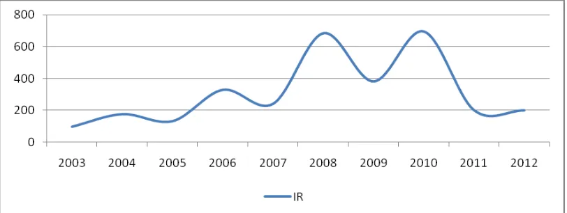
The increase of incidence rate (IR) per 100,000 populations in Central Java province during last three years was reported as follows: 56.8 % in 2010, 15.3% in 2011 and 19.29% in 2012 (Central Java Health Office,2012).2 A few years ago DHF cases only found in urban area, but in this recent time DHF can be found in almost all of both urban and rural areas. In 2007, 33 of 35 districts in Central Java are dengue endemic areas, and in 2008-2009 all over the districts were dengue endemic areas with a fairly high number of cases. In 2010-2011 all regions experienced a decline of DHF cases, but increased again in 2012. During the last three years case fatality rate due to dengue infection in Central Java were reported as follows : 2010 ( 1.29 %), 2011 ( 0.95 % ) and in 2012 ( 1.52 % ) (Central Java Health Office,2012). DHF in Banyumas from 2010 to 2012 showed high IR value: 44.77 ; 12.74 and 11.53 per 100,000 population respectively. (Banyumas Health Office, 2012)i
Global Environmental Change
(GEC) especially Global Warming
contributed to the incidence of dengue infection. In every transition season, especially from dry season to rainy season, many health problems arise including the most common infection such as dengue fever. This implies the vulnerability of the environmental health conditions in Indonesia in terms of prevention, case handling and
patients’ treatment. (Mustofa AJ, 2005).ii
The development of information technology, especially remote sensing methods in the last decade and application of geographic information systems (GIS) will provide a significant contribution in the environmental monitoring of temporal and multi-spatial resolution.
Mapping of dengue cases in Banyumas, Central Java Province spatially was performed in order to analyze the spatial risk factors that affect the incidence of dengue in Banyumas, Central Java Province
using Geographic Information Systems applications and information in the spatial distribution of dengue which include place and time. The results of this study were expected to assist the program in dengue surveillance and control as early precautions of dengue cases.
METHODS
The study of the Dengue spatial distribution was done in Banyumas, Central Java Province, based on dengue cases data from the last 10 year from 2003 to 2012. Stratification village based on dengue cases were divided into: endemic, sporadic and free DHF village. Dengue cases were analyzed based on rainfall from 2010-2012, while the analysis based on land use and population density in the case of transactions are carried out only in 2012. Banyumas topography maps obtained from the Coordinating for Surveys and Mapping Agency (Information of Geospasial Unit) with a scale of 1: 25,000. Data processing (data management) includes editing, coding, entry and analysis of data which were then processed using overlaying Arc Gis 10 program. (Danudoro P, 1996).iii
RESULT
Banyumas is one of the Regency in Central Java province, located between 108°39'17''-109°27'15" east longitude and 7°15'05"-7°37'10" south latitude. Banyumas is consisted of 27 sub-districts with 132,758 ha total areas and 32,307 ha (24.27%) is a rice field. 45% of Banyumas territory is plain areas which are scattered in the central and southern parts, and stretching from West to East. (Banyumas Central Stats Unit, 2014)iv
The situation of dengue cases in Banyumas
Distribution of Dengue cases in Banyumas showed more common in ex Purwokerto Administrative City including East Purwokerto, North Purwokerto, West Purwokerto and South Purwokerto as well as the peripheral District such as Karanglewas, Kembaran and Patikraja. The region is an urban area with a population of 430,064 people (Banyumas Central Stats Unit).
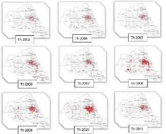
Dengue cases was found in 75% of the districts in Banyumas, whereas the remaining 25% districts in Banyumas were free. Most of the districts without any cases were found in 250 meters above sea level areas. The distribution of dengue cases from 2003 to 2012 which were always concentrated in the ex Purwokerto Administrative City shown in figure 1 below.
Figure 1. Distribution of Dengue Cases in Banyumas during 2003 - 2012
Based on stratification of Dengue endemic areas showed certainly an increase in both the number of dengue cases and the number of endemic village or an expansion in the distribution area from year to year. Until 2012 there were 37 high endemic
villages, 158 villages and 140 villages were endemic low endemic
Distribution of dengue cases based health center region can be seen in Figure 3 below.
Figure 3. DHF cases distribution based on primary public health service area in Banyumas during 2012
Figure 3 emphasize the previous image that dengue cases are concentrated in ex Purwokerto Administrative City (East Purwokerto, North Purwokerto, West Purwokerto and South Purwokerto). Monthly distribution patterns for three consecutive years 2010 – 2012 showed a similar pattern
which dengue cases always raise in January to May and then decline in the next month. This pattern also corresponded with the rainfall pattern. Different pattern occurred in 2012 which cases have increased in the early dry season (Figure 5).
Figure 5. Monthly pattern of DHF cases distribution in Banyumas
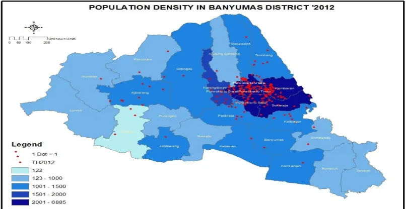
DBD in Banyumas more widely spread in the region with a population dense as the ex Purwokerto Administrative City with a population ranging from 2001 - 6885
peole. In areas with moderate population distribution between 1000 - 2000 people the cases were distributed in moderate levels.
Figure 6. DHF cases distribution based on population density in Banyumas during 2012
Distribution of dengue cases based on the spatial risk factors in Banyumas
Distribution of dengue cases in Banyumas were concentrated in the densely
Figure 7. Distribution pattern of DHF cases based on land use in Banyumas during 2012
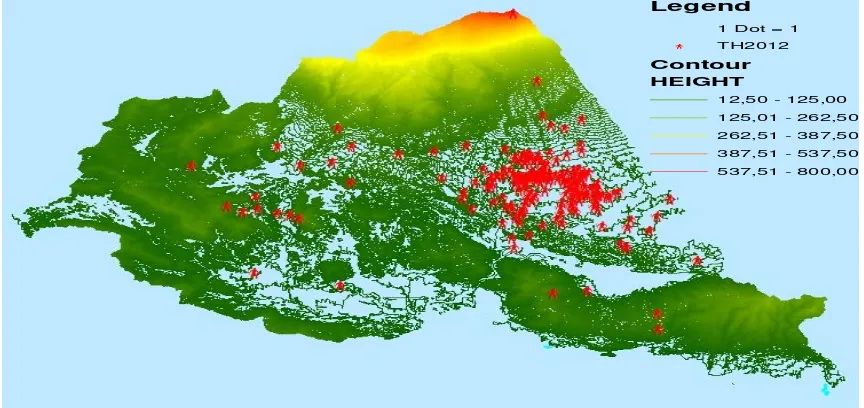
Dengue cases spread in lowland areas. Lowland areas which are potential for dengue cases were ranged between 12.5 to 125 meters above sea level. These locations
include: East Purwokerto, North Purwokerto, West Purwokerto and South Purwokerto sub-district.
Figure 8. Distribution pattern of DHF cases based on altitude in Banyumas during 2012
Legend
1 Dot = 1
b TH2012
Contour
HEIGHT
12,50 - 125,00
125,01 - 262,50
262,51 - 387,50
387,51 - 537,50
Dengue cases in Banyumas were more distributed in areas with moderate rainfall (1000-1500 mm / yr). Dengue cases
were less found in areas with higher rainfall (above 3000 mm / yr).
Figure 9. Distribution pattern of DHF cases based on rainfall in Banyumas during 2012
Health service accessibility in Banyumas also affects on the DHF patients handling. There are three major hospitals such as the General Hospital Prof. Dr. Margono Soekarjo, Banyumas District General Hospital and Ajibarang General
Hospital. Most of DHF cases in Banyumas were hospitalized at General Hospital Prof. Dr. Margono Soekarjo. These cases were distributed within distance of 4 km around General Hospital Prof. Dr.. Margono Soekarjo (Figure 10).
Figure 10. DHF cases distribution and accessibility of general hospital in Banyumas
DISCUSSION
Incidence rate of Dengue Fever in Banyumas in the last ten years showed a saw tooth pattern, an increase occurred in every
1-2 years. Distribution of cases was concentrated in urban areas with dense
populations such as Purwokerto
clustered, indicate the concentrated vector habitat, thus potentially greater local transmission. In general, DHF cases clustering tend to follow the number of population density. The results showed that the dengue cases are more common in urban areas and buffer zones in line with other studies conducted in the Guangzhou region of China that one of the major cities in China and the city of Conghua and Zengcheng buffer that DHF is more common.(Liu C, Qiyong Liu, Hua Liang Lin, Benqiang Xin, Jun Nie, 2013)v
Based on altitude levels, all of dengue cases are found in the lowlands, with a height of 15-250 meters above sea level. Most of the areas in Banyumas have dengue cases and only about a quarter of it which is the area with an altitude of over 250 meters above sea level without any dengue cases, due to these areas were dominantly covered by forest. Most of low land areas with dengue cases were rain fed field. Research in Phitsanulok, Thailand also concluded that housing in the rice fields have a major role in the growth of dengue vectors. (Sarfras MS, Nitin KT, Taravudh T, Thawisak T, Pornsuk K, Marc S, 2012)vi
In general, the pattern of cases increased during the rainy season and decreased during the dry season, it was only in 2012 cases tend to increase during the dry season. This happens because of the wet-dry season occurred in 2012 in Banyumas. According to Sumantri, A (2008) from Research in Jakarta Province states that any additional rainfall 9.73 mm will provide a change to the increased incidence of 67 cases.viiHowever, slightly different from Sumantri, distribution of dengue cases in Banyumas more on areas with moderate rainfall (1000-1500 mm/yr), whereas in areas with the higher rainfall (above 3000 mm / yr) there were fewer cases found. In Southeast Asian countries that annual rainfall of over 2000 mm, making a more stable population of Aedes aegypti in urban, semi-urban and rural areas.(Sukamto, 2007)viiiAreas with moderate to low level of rainfall in Banyumas were located in low-land areas. Moderate to low rainfall can trigger the formation of mosquito breeding habitat, especially on unused stuffs and the surrounding environment. High and very
high rainfall occurred in the highland areas (mountains) with a sparse population. Areas with high rainfall in Banyumas have forested land use, in addition to the high humidity in the area is dry or low humidity is less than optimal for life Aedes sp . According to Sumantri A (2008) every 1.42 % increase in moisture will provide an increased incidence of changes in 372 cases. Rainfall and humidity affect the life optimum value of dengue mosquito vectors, and if the value is exceeded will no longer affect the incidence of dengue. The results of Ethiene study showed humidity effect on reproductive activity and survival of Aedes aegypti, at a temperature of 350C and a relative humidity of 60% will reduce the level of mosquito oviposition (mean 54.53 ± 4.81 eggs ), while a temperature of 250C and relative humidity Soekarjo. These cases were distributed within distance of 4 km around General Hospital Prof. Dr.. Margono Soekarjo. This is because the General Hospital Prof. Dr.. Margono Soekarjo was located in ex Kota Administratif Purwokerto as the area with the most dengue cases is found closest distance. According Thabrany, distance to service centers and travel time has a significant impact with health problems and utilization of health care facilities. (Thabrany in Hotnida Sitorus, Lasbudi, 2014)x Local Government should conduct the curative and preventive effort to control dengue in order to reduce the number of deaths due to DHF, and also prevent nosocomial transmission that may occur in the hospital environment
CONCLUSION
ACKNOWLEDGEMENT
The author would like to thank the Chief Medical Officer of Banyumas especially Head of Environment Health and Communicable Deseases Control Program and his staff who have shared the dengue surveillance data, Head of Banjarnegara Animal Borne Deseases Control Research And Development Unit, National Institute of Health Research and Development, Ministry of Health Republic of Indonesia which always gives opportunities and support for us to write.
REFERENCES
Banyumas Central Stats Unit (2014). Social and Demographic. banyumaskab.bps.go.id. Accessed on January 2nd 2014. Indonesian Banyumas Health Office (2012). DHF Cases in
Banyumas. Indonesian
Central Java Health Office. Animal Borne Disease Situation in Central Java (2012), Scientific Meeting of Banjarnegara Animal Borne Disease Research and Development Unit, Indonesian.
Danudoro P (1996). Digital Image Processing; Pengolahan Citra Digital; Theory and Its Application in Remote Sensing. Faculty of Geography. Gadjah Mada University. Yogyakarta. Indonesian
Thabrany in Ethiene Arruda Pedrosa in Topan Nirwana (2014). Influence of Rainfall, Air Temperature and Humidity Against Dengue fever, URTI and Diarrhea: A Literature Review. Faculty of Medicine. UNPAD Bandung. Accessed on 15th of January 2014.
Available at:
http://pustaka.unpad.ac.id/wpcontent/uploads /2013/02/pustaka_unpad_pengaruh_curah_ hujan_temperatur_dan_kelembaban.pdf
Liu C, Qiyong Liu, Hua Liang Lin, Benqiang Xin, Jun Nie (2013). Spatial Analysis of Dengue Fever in Guang Dong Province, China 2001-2006. Asia - Pacific Journal of Public Health XX(X) 1–9© 2013 APJPH Reprints and permission:sagepub.com/journals
Permissions.nav DOI:
10.1177/1010539512472356. Accessed on 2nd of January 2014. Available at:
http://aph.sagepub.com.)
Ministry of Health Republic of Indonesia (2010). Indonesian Health Profile 2010. Jakarta. The Ministry. Indonesian
Mustofa AJ (2005). Inovasi online. ISSN : 2085-871X | Edisi Vol.3/XVII/Maret 2005. Accessed on 31st of December 2013. Available at:
http://io.ppijepang.org. Indonesian
Sarfras MS, Nitin KT, Taravudh T, Thawisak T, Pornsuk K, Marc S (2012). Analyzing the Spatio-Temporal Relationship Between Dengue Vector Larval Density And Land-Use Using Factor Analysis And Spatial Ring Mapping. Sarfraz et al. BMC Public Health 2012, 12:853 Available at::
http://www.biomedcentral.com/1471-2458/12/853
Sukamto (2007). Study of Characteristic Area with Dengue Haemorhagic Fever Incidence in South Cilacap Subdistrict Cilacap District. Thesis. Post Universitas Diponegoro Semarang. Indonesian
Sumantri A (2008). Model of Environment Based Prevention to Dengue Haemorhagic Fever Spreading in Jakarta Province. Dissertation. Post Graduate Program. Institut Pertanian Bogor. Indonesian