3D MODELLING AND MAPPING FOR VIRTUAL EXPLORATION OF UNDERWATER
ARCHAEOLOGY ASSETS
F. Liarokapis a, P. Kouřil a, P. Agrafiotis b, S. Demesticha c, J. Chmelík a, D. Skarlatos c
a Masaryk University, Faculty of Informatics, HCI Lab, Brno, Czech Republic - (liarokap, 396550, jchmelik)@mail.muni.cz b Cyprus University of Technology, Faculty of Engineering and Technology, Lemesos, Cyprus - (panagiotis.agrafioti,
dimitrios.skarlatos)@cut.ac.cy
c University of Cyprus, Archaeological Research Unit, Nicosia, Cyprus - [email protected]
Commission II
KEY WORDS: Underwater Archaeology, Underwater Photogrammetry, Virtual Reality
ABSTRACT:
This paper investigates immersive technologies to increase exploration time in an underwater archaeological site, both for the public, as well as, for researchers and scholars. Focus is on the Mazotos shipwreck site in Cyprus, which is located 44 meters underwater. The aim of this work is two-fold: (a) realistic modelling and mapping of the site and (b) an immersive virtual reality visit. For 3D modelling and mapping optical data were used. The underwater exploration is composed of a variety of sea elements including: plants, fish, stones, and artefacts, which are randomly positioned. Users can experience an immersive virtual underwater visit in Mazotos shipwreck site and get some information about the shipwreck and its contents for raising their archaeological knowledge and cultural awareness.
1. INTRODUCTION
Underwater archaeological sites are widely spread into the Mediterranean. Unlike land sites, however, submerged settlements, ancient ports, coastal industrial installations, and especially shipwrecks, are not accessible to public or all experts, due to their environment and depth. Photos and surfaced artefacts exhibited in maritime museums provide fragmented aspects of such sites but this is all visitors can actually see. Digital technologies have also been, randomly used, in museum exhibitions, as a supplementary information source, but not always very successfully (Skarlatos et al., 2016). As a result, other means of exhibition is often necessary, aiming at enhancing the visitor’s experience. Recent advances in virtual reality (VR) provide a unique opportunity for digital accessibility to both scholars and general public, interested in having a better grasp of underwater sites and maritime archaeology. Virtual tours are relevant for both scientists and the general public in areas of special interest including shipwrecks or underwater nature reserves (Bosch et al., 2015).
This paper investigates immersive technologies to increase interaction time in an underwater archaeological site, both for the public, as well as, for researchers and scholars. As a test site the Mazotos shipwreck has been selected, since it is practically inaccessible for most people, because of its depth and protection reasons. For 3D modelling and mapping at the aforementioned underwater archaeological site, optical data are used. The imagery taken was based on multiple underwater un-calibrated cameras (in underwater housings), processed using a Structure-from-Motion (SfM) processing pipeline (Demesticha et al., 2014). The resulted 3D models are then fed into the VR application. The immersive underwater VR environment was designed in a way to allow users to visualize archaeological assets. Focus is not on simulating swimming or diving techniques but on exploring underwater archaeological sites. The underwater exploration is composed of a variety of sea elements including: plants, fish, stones, and artefacts, which are
randomly positioned. Users can experience an immersive virtual underwater visit in Mazotos shipwreck site using off-the-self VR headsets (i.e. HTC Vive). Apart from their visit, they can also get some information about the shipwreck and its cargo (i.e. textual descriptions, videos and sounds) for raising their archaeological knowledge and cultural awareness.
The rest of the paper is structured as follows. Section 2 presents background information in terms of underwater modelling and visualisation. Section 3 presents detailed information about the Mazotos shipwreck archaeological site. Section 4 describes the photogrammetric solution followed for modelling the archaeological assets used in the VR visit. Section 5 illustrates the different parts of the immersive virtual environment. Finally, section 6 presents conclusions and future work.
2. BACKGROUND
A vision-based underwater mapping system for shallow waters was demonstrated in an archaeological survey of the submerged ancient town of Pavlopetri (Mahon et al., 2011). The system produced three-dimensional textured models allowing for further archaeological research to be performed, overcoming time limitations that dives usually entail. In another study, the process of automatically creating virtual tours from the most relevant images of the datasets was explored (Bosch et al., 2015). They used an omnidirectional underwater camera in Autonomous Underwater Vehicles (AUVs) that can cover large marine areas with precise navigation.
Moreover, an experimental test-bed for underwater play in a shallow-water installation as precursor demonstration systems for interactivity at depth was explored (Pell and Mueller, 2013). Important design considerations for game designers include the simulation of the signs and symptoms of nitrogen narcosis underwater compared to land.
The most realistic VR simulation to date, called Amphibian, provides an immersive SCUBA diving experience through a terrestrial simulator (Jain et al., 2016). Users lie on their torso on a motion platform with their outstretched arms and legs placed in a suspended harness and receive visual and aural feedback through the Oculus Rift head-mounted display and a pair of headphones. They also simulate buoyancy, drag, and temperature changes through various sensors.
Furthermore, a number of commercial underwater visualization applications exist and the most relevant to underwater shipwreck exploration are either games or virtual explorations. Playstation released a game called 'Treasures of the Deep' that focused on underwater exploration, in order to fulfil objectives such as capping underwater oil leaks, exploring shipwrecks, recovering plane crash victims, destroying hostile installations and finding treasure (Tallarico, 2016). Another example is a 3D dive simulation for mobile devices (Aristidou, 2016) which tries to simulate a virtual dive to the Zenobia wreck. Bangor University designed a VR application for Oculus Rift that allows users to swim through the ocean with underwater creatures like sharks, whales and dolphins (Ocean Rift, 2016). However, none of them are based on accurate archaeological information.
3. THE MAZOTOS SHIPWRECK
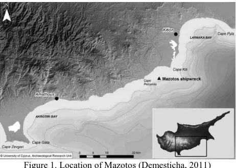
The site is of great archaeological importance since it was virtually undisturbed when discovered. The wreck lies at a depth of -44 m, some 14 nautical miles south-west of Larnaca, 1.5 nm from the shore (Figure 1). The main visible feature of the site is a concentration of amphorae on a sandy, almost flat seabed. Its maximum dimensions are 17.5 x 8 m. The oblong concentration, almost in the form of a ship, has a north-south orientation and consists of 500-800 Chian amphorae partly or totally visible, dating to the middle of fourth century BC (Demesticha, 2011).
Figure 1. Location of Mazotos (Demesticha, 2011)
In the central area of the assemblage, three layers of amphorae can be distinguished. The top layer is the most disturbed one and is jumbled in many areas: most of the amphorae have fallen on their side, so their initial loading position remains uncertain. The containers of the medium layer are fully exposed and in most cases stand upright, like the ones of the lower layer beneath them, which however are half-buried in the sand (Demesticha, 2011). Excavation at the site, still in progress has focused on the bow and the stern and has brought to light parts of the ship’s hull preserved under the dense concentration of the
cargo. Ιtems of secondary cargoes and remains of three anchors have also been found, all in positions only slightly disturbed by the natural formation processes that affected the site after the wreckage.
4. PHOTOGRAMMETRIC MODELLING
Conventional underwater methods are usually based on pure surveying techniques, such as distance measurements and trilateration for network adjustments (Barkai & Kahanov, 2007; Benjamin & Bonsall, 2009) or even on more sophisticated methods, such as use of sound waves for positioning. The use of photogrammetry and computer vision offers, contrary to the above, high accuracy, the ability to measure more details, less contact with the object and the construction of 3D textured models. During the recent years it seems that there is an increasing number of such applications (e.g. Skarlatos et al. 2012, Drap 2012, Demesticha et al., 2014, McCarthy & Benjamin, 2014, Bruno et al., 2015, Balletti et al., 2016).
For the purposes of this project, image sequences from multiple underwater cameras in underwater housings taken from experienced technical divers, are used for reconstruction of the 3D underwater scene of the shipwreck through Structure from Motion (SfM) and Dense Image Matching (DIM) techniques. Through this procedure, a 3D point cloud could be generated assuming sufficient overlap in a group of underwater images. SfM can generate a coarse 3D point cloud based on images taken from multiple viewpoints over an underwater scene. Following the SfM, Multi View Stereo (MVS) can be used to generate a dense 3D point cloud, and corresponding geometry of shapes within a scene. At the end, a mesh surface and a textured 3D model of the underwater scene is generated. A similar procedure is applied on land, modelling recovered archaeological finds such as amphorae, pieces of wood and anchors. These techniques are the state of the art in reconstructing 3D scenes and offer high reliability, high density and high accuracy at a fraction of cost and time of competitive techniques like underwater scanners.
4.1 Data Acquisition
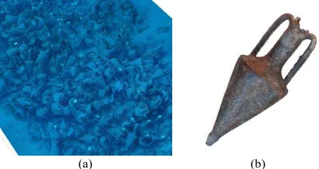
The image acquisition takes place under low natural lighting conditions due to the depth and sometimes in turbid water. Additional light sources were used (flashes) to capture real colours of the study area (Figure 2 a, b). Due to a number of difficulties during the acquisition process leading to low quality images (mainly motion blur), a selection process is applied in order to ensure a most accurate result according to the requirements of the excavation and the significance of the object. Finally, GCPs are used in order to orient and scale the model in a reference system. Scale bars and the same procedure is applied for data acquisition in dry conditions (Figure 2 c) in order to create the 3D models of each amphorae, however without the aforementioned difficulties.
(a) (b) (c)
Figure 2. Underwater image in natural lighting conditions (a) and using artificial lighting (b). Image of a recovered amphorae
(c)
4.2 Data Processing
Nowadays, a new generation of software combines photogrammetric accuracy with computer vision algorithms to reduce the tedious manual labor of common point measuring. This new generation is fully automated and provides a true 3D dense point cloud (3Dpc) over any surface or object with a few simple steps (Demesticha et al, 2014). In this approach, principles of photogrammetry are implemented using computer vision algorithms to create a dense color 3Dpc out of many photos (Skarlatos et al. 2012).
In this section, the image alignment and mesh generation procedure is described for Structure from Motion (SfM) data. The necessary photogrammetric and computer vision procedures were implemented using Agisoft’s PhotoScan® software. Initially the photos are loaded and then are being aligned. At this stage the camera position and orientation for each photo are estimated and a sparse point cloud model is built in an arbitrary reference system (Figure 3 a, b). Following the alignment, measurement of the control points takes place, to register the block in real world coordinates, in the reference system defined by the control points. Self-calibration of cameras, takes place using spare bundle adjustment.
(a) (b) (c) (d)
Figure 3. The estimated camera positions (a), the sparse point cloud, the dense point cloud (c) and the textured 3D model (d)
of Mazotos shipwreck
After an inspection of the alignment results and filtering the outliers in terms of reprojection error, reconstruction accuracy and projection accuracy, the generation of the dense point cloud model takes place. At this stage, based on the estimated camera positions is calculated the depth information for each camera to be combined into a single dense point cloud (Figure 3 c). Before this stage, the desired reconstruction quality is specified. Due to some factors, like poor texture of some elements of the scene, noisy or badly focused images, there can be some outliers among the points.
Finally, the 3D mesh of the shipwreck is created (Figure 3 d) and a texture mapping is applied for better visual quality of the final model (Figure 4 a) and navigation through it. This generic mapping mode allows the parameterization of texture atlas for arbitrary geometry. No assumptions regarding the type of the scene to be processed are made as well as the software tries to create as uniform texture as possible.
A similar procedure to the above and described also in (Papadaki et al., 2015) is applied on land for modelling the surfaced archaeological finds such as amphorae (Figure 4 b), woods and anchors.
(a) (b)
Figure 4. Mazotos shipwreck (a) close up of the textured 3D model and (b) textured 3D model of an Chian amphorae
5. IMMERSIVE VIRTUAL REALITY ENVIRONMENT
Immersion is responsible for producing the feeling of presence (the sensation of being part of the VR environment) as regards the user (Ijsselsteijn and Riva, 2003). One of the aims of this work was to create an immersive VR environment that would be used for the exploration of the Mazotos underwater archaeological site.
The application is developed in Unity engine with support for VR headset HTC Vive. Apart from the HMD (resolution per eye 1080 x 1200, refresh rate λ0 Hz, field of view 110°), HTC Vive comes bundled with two motion tracked controllers and laser based tracking system called Lighthouse providing 6 DOF tracking in an up to 4.5 x 4.5 m area with two beacons. This setup, allows users to perceive a very immersive experience of the underwater Mazotos shipwreck site. Figure 5 presents a screenshot of the immersive underwater VR environment which allows users to visualize archaeological assets.
Figure 5. Underwater visualisation of Mazotos shipwreck in immersive VR
Work done for developing the immersive VR environment consists of four main parts: (a) graphics effects (i.e. lightning, fog), (b) procedural content (i.e. placement of assets), (c) behaviour (i.e. fish movement) and (d) interaction (i.e. exploring and learning).
5.1 Graphics effects
In the VR environment, two types of graphics effects were implemented: lighting and fog. Underwater environment has specific lightning properties compared to standard outside world, especially influenced by color loss of sunlight. White light is composed out of 6 colors - violet, blue, green, yellow, orange and red - ordered by their wavelength, from shortest to furthest. The color loss is affected by multiple factors such as: the coastal proximity, the season, the water surface conditions, the time of the day, the cloudiness of the sky, the presence of
marine vegetation or the soil type (Bianco et al, 2015). The process of color loss is estimated as shown in Figure 6.
Figure 6. Color loss representation (Bianco et al, 2015)
Our application calculates the light’s color loss and intensity based only on the depth of the submerged player. The loss of intensity and color is calculated by using linear interpolation, separately for each component of the light’s color (Red, Blue and Green) to approximate the color loss observed on the graph above. To improve visibility and return the lost colors to objects, player has a head mounted flashlight producing pure white light. Caustics, an element often present in underwater simulations, are not present deeper than 20 meters. This effect is usually faked by projecting a 2D texture on the surface and moving the texture offset, to make their movement animated. While caustics can improve the visual aspect of the application, they are not included in our simulation, because the Mazotos shipwreck is located at -44 meters.
Moreover, distance-based fog with density of 0.06 was used to simulate the small visibility distance usually encountered underwater. Due to the limits of standard Unity forward rendered fog, a height-based fog with density of 0.09 was used to cover terrain before reaching it. Both fogs are using standard exponential squared formula as illustrated below:
2
) (
1
density d
e f
(1)
where e = base of a natural logarithm d = distance from the camera density = user specified
Finally, the simulation is rendered using Forward Rendering, to allow us the usage of MSAA (Multisample Antialiasing), instead of being limited by post processed antialiasing effects like TAA (Temporal Antialiasing) or FXAA (Fast Approximate Antialiasing) when using Deferred Shading. The game is rendered in linear color space to use correct color blending.
5.2 Procedural Content
Placement of all objects is generated procedurally, using a different seed on every start of the application, resulting in different placement of environment, allowing a better replay value of the application. The placement of objects is done in multiple passes to prevent overlapping objects spawning. The amphorae and wood are spawned using a stochastic approach, environmental objects are spawned using noise functions.
The first spawning pass is for the amphorae, using the method for spawning the archaeological artefacts and wood. In particular, they are placed pseudo-randomly by using inverse transform sampling from Cumulative Distribution Function. For our application, we have used exponential distribution with CDF 1 − e−ζx. Input values for the CDF are the coordinates on the terrain plane. Because the middle of the playing area is occupied by actual 3D scan of Mazotos shipwreck, we do not populate this area procedurally. However, the amphorae that were not into the 3D scan are procedurally placed around the site. The number of procedurally placed amphorae is 3 pieces, based on the real findings, with ½ chance to spawn one of two models of amphorae the application contains. It is possible to modify the parameter ζ, which influences the density of placement around the center of playing area.
Second pass spawns pieces of wood. This is done by the same method as amphorae. These are spawned into same area as amphorae, with 20 pieces of wood located around the playing area. Rocks are spawned in third pass. This is done using sampling from a noise function, specifically 2D Perlin Noise. The area for spawning environmental objects is 1.5 times bigger than playing area. The amount of spawned rocks is 30 pieces, again ½ with chance to spawn. All rocks are spawned with different scales and rotations, making them look differently.
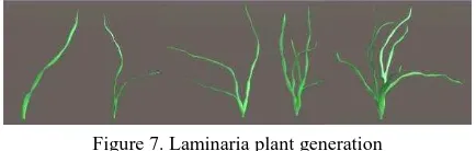
Vegetation is spawned in fourth pass. This is done as well using sampling from 2D Perlin Noise, and the area for spawning is the same as for rocks. The number of vegetation spawned is 3000 plants. There are two types of plants, one being a static model and second one being procedurally generated. They are spawned with 75% chance for the procedurally generated plants. The vegetation animation is calculated on GPU by translating the vertices in the vertex shader function (GPU Gems, 2004).
Figure 7. Laminaria plant generation
For vegetation, the Laminaria plant was chosen to be generated (Figure 7). Each plant leaf is built segment by segment. Each level consists of two base ring of vertices connected with triangles. The algorithm is simple and based on (Procedural Tree, 2015). The parameters of the Laminaria plants that can be modified include: vertices, number of sides, radius properties, roundness, twisting, branching and probability.
The algorithm generates a mesh from scratch. The generation of a bush is represented as a bunch of leaves growing from the same spot. First, the shape of a single leaf segment base is created. After that we randomly determine the number of leaves in the current bush. In a loop we randomly generate twisting and maximum number of levels (leaf segments). Then recursively we generate the Laminaria mesh by adding a new ring of vertices at a time. Randomization of parameters provides that every leaf is unique. The initial shape of a single leaf is defined as a float array of 8 vertices on X and Z axes. The shape is formed by randomizing offset for the basic grass blade shape which in this case is determined as an oval squashed on the short axis. If vertex value is equal to 1, it gives a perfect circle.
By decreasing this number on certain vertices we achieve the needed shape.
For generating branches, three parameters are specified: position (starting at the original object position, where the leaf base will be), a quaternion that represents the direction at which the branch is growing (pointing upwards to start), and a radius of leaf at the current point. Recursively, a new ring of vertices is added to the branch. Starting on the second ring, it iterates through every vertex and builds a quad for each side between current and previous rings using triangle segments. The function applies some random rotation to the quaternion that represents the direction of growing and update the position (center) for the next vertex ring by applying twisting parameters. On every iteration it slightly changes by random values the radius back and forth to draw a curvy shaped plant.
5.3 Behaviour
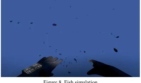
Fish school simulation implementation was based on UnitySteer library (UnitySteer, 2016) which was originally developed by Craig Reynolds (Reynolds, 1987). The algorithm simulates flocking behavior boids (bird-oid objects) - birds and other living species, including fish. This is achieved by agents having behaviour rules, with the 3 basic rules being - separation (steer to avoid crowding), alignment (steer to follow similar trajectory to neighbours) and cohesion (steer to move together with neighbours). Also, as an additional rule, the fish have specified area in which they roam (steer to tether) and consider the player as a menace and try to avoid him by changing their direction (steer to evasion).
Figure 8. Fish simulation
In the virtual visit, there are two types of fish as shown in Figure 8. Both types have different sizes and speeds, spawning groups of 80 and 100 instances. In future, other types of fish could be added to improve the interaction between species - i.e. a new type of fish that would act as a predator to make the schools take different decisions.
5.4 Interface
The initial version of the user interface was prototyped using a projection text approach of a simple menu. Because of the application being developed for HTC Vive, it is not possible to use the screen space coordinates for displaying the interface. Therefore, the user interface was done in the world space coordinate system. In particular, the user’s avatar’s hands were used as the user interface representing a virtual diving computer in the form of watch. When the user approaches an archaeological asset, relevant information (textual description) is automatically provided. Figure 9 presents an example of the
type of information displayed in the VR environment. User can learn some facts about the amphorae.
Figure 9. Interface options for the diver
The user is shown current depth, pressure and remaining time underwater in the user interface. Time of the simulation is limited to 10 minutes, which is standard in underwater diving of 40 meters. While the standard diving computers use pressure to calculate other parameters, our application uses depth as the parameter for calculating information. Depth is taken from the middle of the player avatar. The pressure is calculated as shown below:
HDG
P (2)
where H = depth
D = density of liquid (sea water has a constant density of 1025 kg/m3)
G = acceleration (9.81 ms2)
The 100 kPa of air pressure is added to this result, and then the result is converted to PSI (pound-force per square inch), with the conversion rate of 1 PSI = 6894.76 Pa. The temperature in such deep sites varies between 17 to 19 degrees. In the virtual environment, the temperature was selected to be 1λ° Celsius, which is a typical temperature for summer season.
5.5 Interaction
The user interaction is focused on navigating inside the virtual environment and receiving information about the archaeological assets. The user can either physically walk within a space of 3x3 meters or 'teleport' in the virtual space. Using the controls of the HTC Vive device, one can select the teleporting destination. This allows to 'jump' from one virtual position to another one, without physically moving. Figure 10 illustrates a user interacting with the virtual environment using the controllers.
Figure 10. User interaction
Users can interact directly in the virtual visits only with environmental objects such as wood and rocks. They can pick them up and examine them using the dedicated controllers. However, users are not allowed to interact with the amphorae or the shipwreck. On the contrary, they can receive useful information about the two different types of amphorae as well as the shipwreck. For the amphorae the following type of information is displayed:
Amphoraeμ The Greek word amphora (αηφολεύμ) is composite (αηφί + φέλω) and describes both the form and function of a multi-purpose vessel that could be carried or moved by two handles positioned opposite each other. Transport amphorae were used as containers for organic cargo, usually liquid (olive oil or wine) and they the only kind of ancient vessel designed for sea trade. Of necessity they had to be airtight, capable of being sealed (Knapp and Demesticha 2017: 36-42).
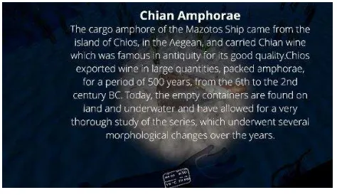
Chian amphorae: The cargo amphorae of the Mazotos ship came from the island of Chios, in the Aegean, and carried the island’s wine, which was famous in antiquity for its good quality. Chios exported wine in large quantities, packed in amphorae, for a period of 500 years, from the 6th to the 2nd century BC. Today, the empty containers are found on land and underwater sites, such as the Mazotos shipwreck. Thus the archaeologists have studied very well the , different morphological changes of this amphora series over the years (Anderson, 1954; Grace and Savvatianou-Pétropoulakou, 1λ70; Lawall, 2000).
Figure 11 presents an exemplar of how the above-mentioned descriptions are applied in the virtual environment.
Figure 11. Archaeological asset description
After reading the textual information, the user can watch a relevant video by pressing the touchpad of the right HTC Vive controller (Figure 10).
6. CONCLUSIONS AND FUTURE WORK
This paper presented initial results for realistic modelling and presentation of underwater archaeological assets. In particular, the Mazotos shipwreck site was selected because it's importance as well as accessibility issues (the site is located 44 meters underwater). The work allows virtual visitors to (a) get an idea of how the shipwreck looks like in VR and (b) educate themselves based on accurate archaeological information about the amphorae and the shipwreck. Interactions have been designed in such a way so that users can easily get the
descriptions and relevant information (i.e. textual descriptions, videos and sounds).
In the future, we are planning in improving the underwater simulation. First, an editable terrain will be implemented based on voxels. Secondly, more archaeological finds will be modelled and imported to the immersive virtual environment. Also we plan to enhance the user interaction, so that users can examine the exposed archaeological assets in more detail. Finally, a formal evaluation will be performed to assess the simulation as well as the whole user experience of underwater virtual archaeological visits.
ACKNOWLEDGEMENTS
This research was part of the i-MareCulture project (Advanced VR, iMmersive Serious Games and Augmented REality as Tools to Raise Awareness and Access to European Underwater CULTURal heritagE, Digital Heritage) that has received funding from the European Union’s Horizon 2020 research and innovation programme under grant agreement No 727153. Authors would like to thank Barbara Dodokova and Polina Gusenkova for assisting in the generation of the underwater vegetation.
REFERENCES
Anderson, J. K., 1954. Excavations on the Kofina Ridge, Chios, Annual of the British School at Athens, 49, pp. 123-172.
Balletti, C., Beltrame, C., Costa, E., Guerra, F., & Vernier, P. 2016. 3D reconstruction of marble shipwreck cargoes based on underwater multi-image photogrammetry. Digital Applications in Archaeology and Cultural Heritage, 3(1), pp. 1-8.
Barkai, O., Kahanov, Y., 2007. The Tantura F shipwreck, Israel. International Journal of Nautical Archaeology, 36(1), pp. 21-31.
Benjamin, J., Bonsall, C., 2009. A feasibility study for the investigation of submerged sites along the coast of Slovenia. International Journal of Nautical Archaeology, 38 (1), pp. 163-172.
Bianco, G., Muzzupappa, M., Bruno, F., Garcia, R., Neumann, L., 2015. A New Color Correction Method for Underwater Imaging, In: ISPRS - International Archives of the Photogrammetry, Remote Sensing and Spatial Information Sciences, Volume XL-5/W5, pp. 25-32.
Bosch, J., Ridao, P., Ribas, D., Gracias, N., 2015. Creating 360° underwater virtual tours using an omnidirectional camera integrated in an AUV. In: OCEANS 2015 - Genova, IEEE Computer Society, 18-21 May.
Bruno, F., Lagudi, A., Gallo, A., Muzzupappa, M., Petriaggi, B. D., & Passaro, S. 2015. 3D documentation of archeological remains in the underwater park of Baiae. The International Archives of Photogrammetry, Remote Sensing and Spatial Information Sciences, 40(5), 41.
Ocean Rift 2016, http://llyrie.blogspot.cz/p/ocean-rift.html, (22 Nov. 2016).
Demesticha, S., 2011. The 4th‐Century‐BC Mazotos Shipwreck,
Cyprus: a preliminary report. International Journal of Nautical Archaeology, 40.1, pp. 39-59.
Demesticha, S., Skarlatos, D., Neophytou, A. 2014. The 4th-century BC shipwreck at Mazotos, Cyprus: New techniques and methodologies in the 3D mapping of shipwreck excavations. Journal of Field Archaeology, 39(2), pp. 134-150.
Drap, P. 2012. ‘‘Underwater Photogrammetry for Archaeology, Special Applications of Photogrammetry,’’ in D. Carneiro da
Silva ed., InTech,
http://www.intechopen.com/books/specialapplications-of photogrammetry/underwater-photogrammetryfor-archaeology
GPU Gems, 2004. "Chapter 7. Rendering Countless Blades of
Waving Grass",
http://http.developer.nvidia.com/GPUGems/gpugems_ch07.html (22 Nov. 2016)
Grace, V. and Savvatianou-Pétropoulakou, M., 1λ70, Les timbres amphoriques grecs. In: Ph. Bruneau, Cl. Vatin, U. Bezerra de Meneses, G. Donnay, E. Lévy, A. Bovon, G. Siebert, V. R. Grace, M. Savvatianou-Pétropoulakou, E. Lyding Will and T. Hackens, L’îlot de la maison des comédiens. Exploration archéologique de Délos XXVII, Paris, pp. 277-382.
Ijsselstein, W., Riva, G., 2003. Being there: the experience of presence in mediated environments. In: Being There: Concepts, effects and measurement of user presence in synthetic environments. G. Riva, F. Davide, W.A IJsselsteijn (Eds.) Ios Press, Amsterdam, The Netherlands, pp. 1-14.
Jain, D., Sra, M., Guo, J., Marques, R., Wu, R., Chiu, J., Schmandt, C., 2016. Immersive Terrestrial Scuba Diving Using Virtual Reality. In: Proc. of the 2016 CHI Conference Extended Abstracts on Human Factors in Computing Systems, Santa Clara, California, USA, 07-12 May, pp. 1563-1569.
Knapp, A.B., and Demesticha, S. 2017. Mediterranean Connections: Maritime Transport Containers and Seaborne Trade in the Bronze and Iron Ages. New York, NY London: Routledge, Taylor & Francis Group.
Lawall, M.L., 2000. Graffiti, Wine Selling, and the Reuse of Amphoras in the Athenian Agora, ca.430 to 400 BC, Hesperia 69, pp. 3-90.
Mahon, I., Pizarro, O., Johnson-Roberson, M., Friedman, A., Williams, S.B., Henderson, J.C., 2011. Reconstructing Pavlopetri: Mapping the world's oldest submerged town using stereo-vision. In: Proc. IEEE International Conference on Robotics and Automation (ICRA), 9-13 May, pp. 2315-2321.
McCarthy, J., & Benjamin, J. 2014. Multi-image photogrammetry for underwater archaeological site recording: an accessible, diver-based approach. Journal of maritime archaeology, 9(1), pp. 95-114.
Papadaki, A. I., Agrafiotis, P., Georgopoulos, A., & Prignitz, S. (2015). Accurate 3d Scanning of Damaged Ancient Greek Inscriptions for Revealing Weathered Letters. The International Archives of Photogrammetry, Remote Sensing and Spatial Information Sciences, 40(5), 237.
Pell, S.J., Mueller, F., 2013. Designing for Depth: Underwater Play. In: Proc. of 9th Australasian Conference on Interactive Entertainment: Matters of Life and Death, ACM Press, Article
No. 24, Melbourne, Australia, September 30-October 01.
Perlin, K., 1985. An image synthesizer. In: Proc. of the 12th Annual Conference on Computer Graphics and Interactive Techniques (SIGGRAPH '85), ACM Press, pp. 287-296.
Procedural Tree, 2015. "Unity Asset Store", https://www.assetstore.unity3d.com/en/#!/content/32907 (22 Nov. 2016)
Reynolds, C.W., 1987. Flocks, herds and schools: A distributed behavioral model. In: Proc. of the 14th Annual Conference on Computer Graphics and Interactive Techniques (SIGGRAPH '87), ACM Press, pp. 25-34.
Skarlatos, D., Agrafiotis, P., Balogh, T., Bruno, F., Castro, F., Davidde Petriaggi B., Demesticha, S., Doulamis, A., Drap, P., Georgopoulos, A., Kikillos, F., Kyriakidis, P., Liarokapis, F., Poullis, C., Rizvic S., 2016. Project iMARECULTURE: Advanced VR, iMmersive Serious Games and Augmented REality as Tools to Raise Awareness and Access to European Underwater CULTURal heritagE. In: Digital Heritage. Progress in Cultural Heritage: Documentation, Preservation, and Protection, Volume 10058 of the series Lecture Notes in Computer Science, pp. 805-813.
Skarlatos, D., Demestiha, S., & Kiparissi, S., 2012. An ‘open’method for 3D modelling and mapping in underwater archaeological sites. International Journal of Heritage in the Digital Era, 1(1), pp. 1-24.
Tallarico, T., 2016. "Treasures of the Deep. Sony Playstation", https://www.playstation.com/en-us/games/treasures-of-the-deep-psone/ (22 Nov. 2016).
UnitySteer 2016. "GitHub",
http://numergent.com/tags/unitysteer/ (22 Nov. 2016)
Revised Jan 2017