Open Geospatial Consortium
Date: 2011-04-25
Reference number of this OGC® project document: OGC 09-083r3
Version: 3.0.0
Category: OGC® Implementation Standard Editor: Adrian Custer
GeoAPI 3.0 Implementation Standard
Copyright notice
Copyright © 2009-2011 Open Geospatial Consortium
To obtain additional rights of use, visit http://www.opengeospatial.org/legal/.
Warning
This document is an OGC Member approved international standard. This document is available on a royalty free, non-discriminatory basis. Recipients of this document are invited to submit, with their comments, notification of any relevant patent rights of which they are aware and to provide supporting documentation.
Document type: OGC® Publicly Available Implementation Standard Document stage: Approved
License Agreement
Permission is hereby granted by the Open Geospatial Consortium, ("Licensor"), free of charge and subject to the terms set forth below, to any person obtaining a copy of this Intellectual Property and any associated documentation, to deal in the Intellectual Property without restriction (except as set forth below), including without limitation the rights to implement, use, copy, modify, merge, publish, distribute, and/or sublicense copies of the Intellectual Property, and to permit persons to whom the Intellectual Property is furnished to do so, provided that all copyright notices on the intellectual property are retained intact and that each person to whom the Intellectual Property is furnished agrees to the terms of this Agreement.
If you modify the Intellectual Property, all copies of the modified Intellectual Property must include, in addition to the above copyright notice, a notice that the Intellectual Property includes modifications that have not been approved or adopted by LICENSOR.
THIS LICENSE IS A COPYRIGHT LICENSE ONLY, AND DOES NOT CONVEY ANY RIGHTS UNDER ANY PATENTS THAT MAY BE IN FORCE ANYWHERE IN THE WORLD.
THE INTELLECTUAL PROPERTY IS PROVIDED "AS IS", WITHOUT WARRANTY OF ANY KIND, EXPRESS OR IMPLIED, INCLUDING BUT NOT LIMITED TO THE WARRANTIES OF MERCHANTABILITY, FITNESS FOR A PARTICULAR PURPOSE, AND NONINFRINGEMENT OF THIRD PARTY RIGHTS. THE COPYRIGHT HOLDER OR HOLDERS INCLUDED IN THIS NOTICE DO NOT WARRANT THAT THE FUNCTIONS CONTAINED IN THE INTELLECTUAL PROPERTY WILL MEET YOUR REQUIREMENTS OR THAT THE OPERATION OF THE INTELLECTUAL PROPERTY WILL BE UNINTERRUPTED OR ERROR FREE. ANY USE OF THE INTELLECTUAL PROPERTY SHALL BE MADE ENTIRELY AT THE USER’S OWN RISK. IN NO EVENT SHALL THE COPYRIGHT HOLDER OR ANY CONTRIBUTOR OF INTELLECTUAL PROPERTY RIGHTS TO THE INTELLECTUAL PROPERTY BE LIABLE FOR ANY CLAIM, OR ANY DIRECT, SPECIAL, INDIRECT OR CONSEQUENTIAL DAMAGES, OR ANY DAMAGES WHATSOEVER RESULTING FROM ANY ALLEGED INFRINGEMENT OR ANY LOSS OF USE, DATA OR PROFITS, WHETHER IN AN ACTION OF CONTRACT, NEGLIGENCE OR UNDER ANY OTHER LEGAL THEORY, ARISING OUT OF OR IN CONNECTION WITH THE IMPLEMENTATION, USE, COMMERCIALIZATION OR PERFORMANCE OF THIS INTELLECTUAL PROPERTY.
This license is effective until terminated. You may terminate it at any time by destroying the Intellectual Property together with all copies in any form. The license will also terminate if you fail to comply with any term or condition of this Agreement. Except as provided in the following sentence, no such termination of this license shall require the termination of any third party end-user sublicense to the Intellectual Property which is in force as of the date of notice of such termination. In addition, should the Intellectual Property, or the operation of the Intellectual Property, infringe, or in LICENSOR’s sole opinion be likely to infringe, any patent, copyright, trademark or other right of a third party, you agree that LICENSOR, in its sole discretion, may terminate this license without any compensation or liability to you, your licensees or any other party. You agree upon termination of any kind to destroy or cause to be destroyed the Intellectual Property together with all copies in any form, whether held by you or by any third party.
Except as contained in this notice, the name of LICENSOR or of any other holder of a copyright in all or part of the Intellectual Property shall not be used in advertising or otherwise to promote the sale, use or other dealings in this Intellectual Property without prior written authorization of LICENSOR or such copyright holder. LICENSOR is and shall at all times be the sole entity that may authorize you or any third party to use certification marks, trademarks or other special designations to indicate compliance with any LICENSOR standards or specifications.
This Agreement is governed by the laws of the Commonwealth of Massachusetts. The application to this Agreement of the United Nations Convention on Contracts for the International Sale of Goods is hereby expressly excluded. In the event any provision of this Agreement shall be deemed unenforceable, void or invalid, such provision shall be modified so as to make it valid and enforceable, and as so modified the entire Agreement shall remain in full force and effect. No decision, action or inaction by LICENSOR shall be construed to be a waiver of any rights or remedies available to it.
Content
i. Abstract ... iv
ii. Preface ... v
iii. Submitting organizations ... vii
iv. Submission contact points ... vii
v. Changes to the OGC® Abstract Specification ... vii
vi. Foreword ... viii
vii. Introduction ... ix
1. Scope ... 1
2. Conformance ... 1
3. Normative references ... 2
4. Terms and definitions ... 3
4.1 Application Programming Interface (API) ... 3
4.2 Java ... 3
5. Conventions ... 3
5.1 Symbols (and abbreviated terms) ... 3
6. A Geographic API in Java ... 5
7. Annotation package ... 6
7.1 Use of the annotation types ... 6
8. Utility package ... 7
8.1 Package Mapping ... 8
8.1.1 Primitive Types ... 8
8.1.2 Collection and dictionary types ... 9
8.1.3 Enumerated types ... 10
8.1.4 Representation types ... 10
8.1.5 Name types ... 11
8.1.6 Derived types ... 11
8.2 Use of the utility types ... 12
8.3 Departure from ISO 19103 ... 13
8.4 Future improvements ... 14
9. Metadata packages ... 15
9.1 Package mapping ... 15
9.2 Use of the GeoAPI metadata packages ... 16
9.3 Departures from standard ... 17
9.4 Future work ... 18
10. Geometry packages ... 20
10.2 Use of the geometry packages ... 21
10.3 Departure from Standards ... 21
10.4 Future work ... 21
11. Referencing and Parameter packages ... 22
11.1 Package Mapping ... 24
11.2 Use of the referencing and parameter types ... 24
11.2.1 Creating a Projected Coordinate Reference System ... 24
11.2.2 Build a Coordinate Operation ... 25
11.2.3 Transform a coordinate between coordinate reference systems. ... 26
11.3 Departure from Standards ... 26
i. Abstract
ii. Preface
This GeoAPI standard evolved from a long effort at the Open Geospatial Consortium (OGC) and in the free software community focused on developing a library of interfaces defining a coherent data model for the manipulation of geospatial data based on the data model defined in the OGC Abstract Specification. The GeoAPI library has been developed to facilitate the creation of interoperable, standards compliant, Java language software.
The GeoAPI interface library originates with the publication in January 2001 of the implementation specification OGC 01-009 Coordinate Transformation Services Revision 1.00 (Martin Daly, ed.) which included a set of interfaces written in the Java language and in the org.opengis namespace. The GeoAPI project started in 2003 as an effort from several contributors to develop a set of Java language interfaces which could be shared between several projects. The GeoAPI project subsequently considered the interfaces of OGC 01-009 as version 0.1 of the GeoAPI library and started working on GeoAPI 1.0 in collaboration with developers writing the OGC specification Geographic Objects. Subsequently, the Open Geospatial Consortium jettisoned its own Abstract Specifications and adopted, as the basis for further work, the standards developed by the Technical Committee 211 of the International Organization for Standardization (ISO) in its ISO 19100 series. The GeoAPI project therefore realigned its library with those standards. In 2003, version 1.0 of the GeoAPI library was released to match the release of the first public draft of the implementation specification OGC 03-064 GO-1 Application Objects Version 1.0 (Greg Reynolds, ed.). The standardization effort of GO-1 took a couple of years during which extensive work was made on the GeoAPI library. Release 2.0 of the GeoAPI library was made at the time of the final publication of the GO-1 specification in 2005. This brief historical synopsis explains why this specification adopts the version number 3.0 despite there being no prior OGC specification of the same name. We expect to release version 3.0 of the GeoAPI library with the final version of this specification.
iii. Submitting organizations
The following organizations submitted this Implementation Standard to the Open Geospatial Consortium:
a)Geomatys, Arles, France.
iv. Submission contact points
All questions regarding this submission should be directed to the editor:
Martin Desruisseaux Geomatys
24, Rue Pierre-Renaudel 13200 Arles, France
v. Changes to the OGC® Abstract Specification
vi. Foreword
The GeoAPI interface library is developed by the GeoAPI project (http://www.geoapi.org/). These interfaces have been developed over a number of years with contributors acting as individual volunteers, as government or institutional workers, or as employees in technology companies. The formal list of contributors is maintained in the project documentation at http://www.geoapi.org/team-list.html but many others have contributed to the project through discussions at meetings of the Technical Committee of the OGC, on the project mailing lists and elsewhere, by working on implementations or client code of the GeoAPI interfaces, or by helping with other concerns of the project.
This standard complements existing OGC standards by defining a new, language specific layer of normalization. This standard does not replace the core standards developing the ISO/OGC abstract model but complements those documents for developers who use the Java language by documenting the mapping of types and methods from the abstract model into Java and explaining the use of the GeoAPI library. Because this standard differs in design and ambition from earlier OGC specifications which also included Java language interfaces, this document has been proposed as a new standardization effort in its own right.
The GeoAPI Javadoc completed by the annexes A (Conformance) and B (Source Java Archives) are normative, while the annexes C (Types and methods), D (UML diagram for referencing operation types), E (Departures from ISO standards) and F (Comparison with legacy OGC specifications) are informative.
The interfaces described in this standard follow directly, without introducing any new concepts, from the previously published standards of the Open Geospatial Consortium and the International Organization for Standardization. Nonetheless, attention is drawn to the possibility that some of the elements of this document may be the subject of patent rights. The Open Geospatial Consortium Inc. shall not be held responsible for identifying any or all such patent rights.
vii. Introduction
The GeoAPI Implementation Standard defines the normalized use of the GeoAPI library.
The GeoAPI library contains a series of interfaces and classes in the Java language defined in several packages which interpret into Java the data model and UML types of the ISO and OGC standards documents. The library includes extensive Javadoc code documentation which complement the injunctions of the ISO/OGC specifications by explaining particularities of the GeoAPI library: interpretations made of the specifications where there was room for choice, constraints due to the library's use of Java, or standard patterns of behavior expected by the library, notably in its handling of return types during exceptional situations.
This document explains the GeoAPI library and defines its use by library code implementing the API and by client code calling the API. Jointly with the library itself, this work aims to provide a carefully considered interpretation of the OGC specifications for the Java language, to provide a base structure to facilitate the creation of software libraries which implementing OGC standards, and to give application developers a well defined, full documented binding reducing the programming effort of using the OGC abstract model and facilitating the portability of application code between different implementations. The interfaces defined in this standard provide one way to structure the use the Java language to implement software which follows the design and intents of the OGC/ISO specifications. The creators of the GeoAPI interfaces consider this approach as an effective compromise between the OGC specifications, the requirements of the Java language, and the tradition of the core Java libraries.
GeoAPI Implementation Standard
1. Scope
The GeoAPI Implementation Standard defines, through the GeoAPI library, a Java language application programming interface (API) including a set of types and methods which can be used for the manipulation of geographic information structured following the specifications adopted by the Technical Committee 211 of the International Organization for Standardization (ISO) and by the Open Geospatial Consortium (OGC). This standard standardizes the informatics contract between the client code which manipulates normalized data structures of geographic information based on the published API and the library code able both to instantiate and operate on these data structures according to the rules required by the published API and by the ISO and OGC standards.
The normative publication of the library occurs in a Java Archive (JAR) format binary. That binary is distributed along with a ZIP format bundle of the Javadoc comments as HTML files. An online version of the Javadoc comments, which may contain fixes for errata discovered after publication of this specification, is available at the URL http://www.geoapi.org/3.0/javadoc/index.html.
Version 3.0 of the library covers the base of the OGC Abstract Model for geographic information. GeoAPI 3.0 provides utilities, base types, metadata structures, and geo-referencing data elements which enable the creation of reference systems for spatial coordinates related to the Earth and of mathematical operators to convert coordinates from one coordinate reference system to another. This version of the standard covers the specifications ISO 19103, ISO 19115, ISO 19111, some elements from the closely related OGC™ specification OGC 01-009 and four elements from ISO 19107 necessary to the implementation of ISO 19111. Future versions of this specification are expected to expand this set of interfaces to cover the full model of the OGC Abstract Specification series, including notably Coverage and Feature data structures, with the 'pending' portion of the GeoAPI project already exploring these new areas.
2. Conformance
to follow the best practices for use of the API which are documented in the Javadoc comments of GeoAPI as well as elsewhere, including herein.
This specification makes certain requirements of libraries implementing this API and defines several conformance classes for implementations covering different packages of the API or providing different levels of complexity in their implementations. These requirements and conformance classes are presented in Annex A (normative).
GeoAPI does not currently have any formal test suite through which to establish conformance of GeoAPI implementations. The construction of such a test suite presents several complex challenges which may be tackled over time. However, GeoAPI does include a validation framework which can be used during unit testing as explained in Annex A.
3. Normative references
The following normative documents contain provisions which, through reference in this text, constitute provisions of this specification, OGC 09-083r3, except for any departures from the listed specifications which are explicitly mentioned in this text. For dated references, subsequent amendments to, or revisions of, any of these publications do not apply. However, parties to agreements based on this specification, OGC 09-083r3, are encouraged to investigate the possibility of applying the most recent editions of the normative documents indicated below. For undated references, the latest edition of the normative document referred to applies.
ÓISO 19103, Geographic information — Conceptual schema language, 2005. ÓISO 19115, Geographic information — Metadata, 2003.
ÓISO 19115, Geographic information — Metadata / Corrigendum 1, 2006.
ÓISO 19115-2, Geographic information — Extensions for imagery and gridded data, 2007. ÓISO 19111, Geographic information — Spatial referencing by coordinates, 2007.
ÓOGC 01-009, OpenGIS® Implementation Specification: Coordinate Transformation Services, revision 1.00, 2001 (partially)
ÓThe Java Language Specification, 3rd Edition. James Gosling, Bill Joy, Guy Steele, Gilad Bracha, Sun Microsystems, 2005.
The normative reference towards the ISO metadata standard, ISO 19115, follows the lead of ISO 19111 in excluding all references to MD_CRS and associated types. ISO 19111 states:
"Normative reference to ISO 19115 is restricted as follows: in this international standard, normative reference to ISO 19111 excludes the MD_CRS class and its components classes."
ISO 19111:2007, section 3 "Normative References" Despite this statement here, this is documented as a departure from the standard in annex E.
4. Terms and definitions
For the purposes of this document, the following terms and definitions apply.
4.1 Application Programming Interface (API)
A formally defined set of types and methods which establish a contract between client code which uses the API and implementation code which provides the API.
4.2 Java
Trademark of Oracle used to refer to an object oriented, single inheritance programming language whose syntax derives from the C programming language and which is defined by the Java Language Specification.
5. Conventions
The conventions in this document follow the model of the ISO 19100 series specifications and standard practice in the fields of geographic information systems and software programming.
5.1 Symbols (and abbreviated terms)
API Application Program Interface
UML Unified Modeling Language XML eXtended Markup Language
1D One Dimensional
2D Two Dimensional
3D Three Dimensional
6. A Geographic API in Java
The GeoAPI library formalizes the handling of the types defined in the specification documents for working with geographic information adopted by the International Organization for Standardization (ISO) and the Open Geospatial Consortium (OGC). Whereas the specifications define data types, methods and relationships using the general UML notation, the GeoAPI library implements those standards as Java language interfaces or simple classes. The GeoAPI types jointly form an application programming interface (API) which provides two groups of developers with a common point of exchange. Developers wishing to implement code which fulfills the requirements of the ISO and OGC specifications can adopt GeoAPI as a roadmap for their development. Developers wishing to write code which uses the data types defined by the standards can simply call the methods of the interfaces; they also gain a measure of independence from the particular implementation they are using since another implementation of the API can be swapped without breaking any calls made to the GeoAPI interfaces.
The structure of the GeoAPI library mirrors the packaging and separation of the different ISO and OGC specifications by grouping different types and functionality in separate Java language packages.
Figure 1: ISO specifications and GeoAPI packages mapping
not defined in Java which are provided in the org.opengis.util package. The packages in the org.opengis.metadata namespace cover the data types defined in the ISO 19115 Metadata specification which are data structures holding textual references to elements describing other structures. The packages in the org.opengis.parameter and org.opengis.referencing namespaces implement the types from the ISO 19111 Spatial Referencing by Coordinates specification complemented by the mathematical operator types from the OGC 01-009 Implementation specification Coordinate Transformation Services. The packages in the org.opengis.geometry namespace cover the data types defined in the ISO 19107 Spatial Schema specification, although in version 3.0 of the library only defines the elements from that specification needed by the geo-referencing types defined in the OGC 01-009 specification since these packages are inter-dependent.
7. Annotation package
The GeoAPI annotation package uses the org.opengis.annotation namespace and implements Java language annotations and supporting classes which enable GeoAPI to document the origin, original name, and necessity of the various types and methods integrated from the various specification documents.
All classes in GeoAPI, including interfaces and enumeration types, which are based on a published standard should have an annotation label "@UML" documenting the standard in which are defined the type or method, the original name of the element and the obligation level of the type if other than the default mandatory level of obligation.
7.1 Use of the annotation types
As an example, the annotation label for the ProjectedCRS interface appears in the source code as:
@UML(identifier = "SC_ProjectedCRS", specification = ISO_19111)
which specifies that the type was defined in ISO 19111 standard, in the SC "Coordinate Reference System" package as the type "GeographicCRS" while the method getCoordinateSystem() of that class has the annotation:
@UML(identifier = "coordinateSystem", obligation = MANDATORY,
which indicates that the method was defined in the same ISO 19111 specification but had the name "coordinateSystem" in the standard rather than the "getCoordinateSystem" name used by GeoAPI and that a non-null value must be provided by every ProjectedCRS instance.
These annotations are available at runtime by Java introspection. This is useful, for example, when code needs to marshall data using the name defined by the ISO standard rather than the GeoAPI name. At runtime, the annotation of a reference to a GeoAPI interface can be obtained as follows, taking as an example the method getTitle() in the Citation type:
Class<?> type = Citation.class;
Method method = type.getMethod("getTitle", (Class<?>[]) null); UML annot = method.getAnnotation(UML.class);
String ident = annot.identifier(); Specification spec = annot.specification(); Obligation obl = annot.obligation();
Java provides a class instance like the Citation.class instance used here for every type, either interface or class, defined in the runtime. The getMethod(…) call uses introspection to obtain a reference to the method from which the annotation can then be obtained. The annotation system therefore provides access, at runtime, to the original definition of the element.
8. Utility package
The GeoAPI utility package uses the org.opengis.util namespace and implements the types which are defined in the specification from the International Organization for Standardization ISO 19103:2005 Geographic Information – Conceptual schema language but are not already present in the Java language itself or in the standard Java library.
The Java types mapped by GeoAPI or provided in the utility package can be used like regular Java language elements. Most of the types can be instantiated directly through public constructors. Enumeration types provide public access to each of their constants. CodeList types provide the static valueOf(…) method through which instances can be obtained. The NameFactory interface provides public methods for the instantiation of the various GenericName types. GeoAPI does not specify any extra constraints on the behavior or use of these types.
8.1 Package Mapping
GeoAPI maps the types of ISO 19103 into equivalents from the Java language and library or into types defined in the utility package. However, not all of the types in ISO 19103 have had a mapping defined because the need for these types has not yet appeared since they have not yet appeared in any other specification for which GeoAPI defines interfaces. Such types are listed as 'unimplemented' in the tables below.
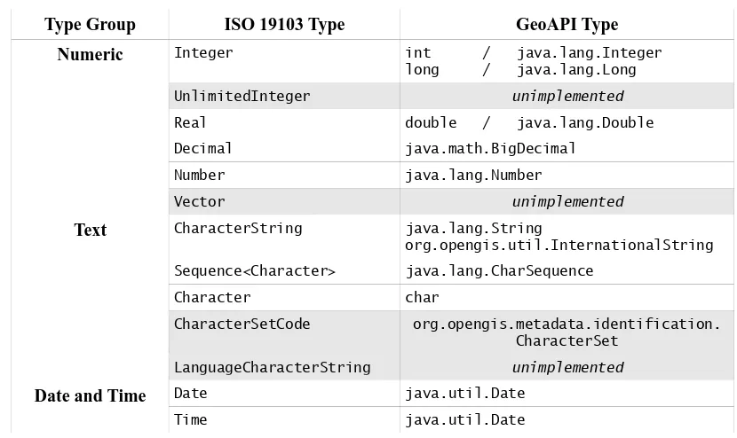
8.1.1 Primitive Types
The Primitive types of the ISO/OGC specifications map to single object structures in GeoAPI. Where the mapping can be made directly to a Java primitive type, such as int and double, the Java primitive is preferred; however, when the value must be able to be set to null, the object wrapper of that primitive is used.
The following table shows the mapping used by GeoAPI to represent the types in the ISO 19100 series.
Table 1: Primitive Types Mapping
Type Group ISO 19103 Type GeoAPI Type Numeric Integer int / java.lang.Integer
Date and Time Date java.util.Date
DateTime java.util.Date
DatePrecision unimplemented
Truth Probability unimplemented
Boolean boolean / java.lang.Boolean
Logical unimplemented
Truth unimplemented
DiscreteTruth unimplemented
ContinuousTruth unimplemented Multiplicities Multiplicity unimplemented
MultiplicityRange unimplemented
Enumerations Sign unimplemented
Digit unimplemented
Bit unimplemented
Several of the objects in ISO 19103 have not been implemented since they have not yet been needed during the development of the rest of the interfaces. GeoAPI will consider implementing these types when they become necessary for the implementation of other elements in the ISO and OGC standards.
The interface InternationalString is an extension used by GeoAPI to handle Java String objects which may potentially need to be translated for users of different locales. Conceptually this acts as a String but may, depending on the implementation, provide access to locale specific representations of that String. This is useful, for example, when an implementation is operating on a server that serves multiple languages simultaneously, to allow sending String representations in the locale of the client rather than the locale of the server running the GeoAPI implementation.
Note: InternationalString is inspired by JSR-150 (Internationalization Service for
J2EE) with support for different timezones omitted.
8.1.2 Collection and dictionary types
GeoAPI implements ISO 19103 collection types using the standard Java Collections Framework. The one major difference is that GeoAPI collections do not implement the TransfiniteSet interface.
Table 2: Collection and Dictionary Types Mapping
ISO 19103 Type GeoAPI Type
Transfinite Set unimplemented
Collection java.util.Collection
Set java.util.Set
Sequence java.util.List
CircularSequence unimplemented
Dictionary java.util.Map
KeyValuePair java.util.Map.Entry
These collection types are used within GeoAPI qualified with a parametric type, which does not quite follow strictly the template notion which these types have in the ISO standards but is the closest one can conveniently do in the Java language.
8.1.3 Enumerated types
GeoAPI distinguishes between two enumerated types depending on whether the complete set of literal types is known when the code is originally created or if the list may be extended at run time or when the code is extended. The Java language provides the Enum language construct for the former case and GeoAPI defines the CodeList interface for the latter case.
Table 3: Enumerated Types Mapping
ISO 19103 Type GeoAPI Type
Enumeration java.lang.Enum
CodeList org.opengis.util.CodeList
8.1.4 Representation types
GeoAPI currently defines only a strict minimum of the representation types in order to cover those necessary for the coverage package implementing the types in ISO 19123.
Table 4: Representation Types Mapping
ISO 19103 Type GeoAPI Type
Schema Unimplemented
Any java.lang.Object
Type org.opengis.util.Type
RecordSchema org.opengis.util.RecordSchema
RecordType org.opengis.util.RecordType
8.1.5 Name types
The name types in ISO 19103 have little documentation. The current explanation for how we interpret this Name system is in the Javadoc for GenericName:
http://www.geoapi.org/snapshot/javadoc/org/opengis/util/GenericName.html
which explains our current interpretation of scopes and namespaces.
Table 5: Name Types Mapping
ISO 19103 Type GeoAPI Type
(constructors) org.opengis.util.NameFactory
NameSpace org.opengis.util.NameSpace
GenericName org.opengis.util.GenericName
ScopedName org.opengis.util.ScopedName
LocalName org.opengis.util.LocalName
TypeName org.opengis.util.TypeName
MemberName org.opengis.util.MemberName
The NameFactory is an extension of the GeoAPI project designed to allow the construction of instances of these Name types.
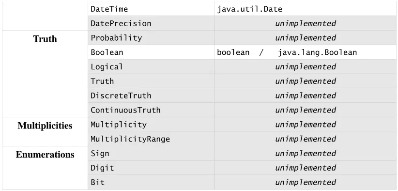
8.1.6 Derived types
The derived types from ISO 19103 are almost all related to units and measurements. GeoAPI relies for these types on the interfaces defined by the external project JSR-275. The JScience
project (http://jscience.org/) provides an implementation of these APIs.
The UOMo interfaces rely extensively on parametrized types to qualify the type of Unit or Measure being used.
Table 6: Derived Types Mapping
ISO 19103 Type GeoAPI Type
Measure javax.measure.quantity.Quantity
UnitOfMeasure javax.measure.unit.Unit<? extends Quantity> Area javax.measure.quantity.Area
UomArea javax.measure.unit.Unit<Area>
Distance javax.measure.quantity.Length
GeoAPI uses the Java language keyword null to represent the ISO NULL value and the empty set from the Java Collections Framework for the ISO EMPTY. Note that programmers, for type safety when using Java Generics, should call the method java.util.Collections.emptySet() rather than refer directly to the constant, since the former will have the parametric type at compile time.
8.2 Use of the utility types
Use of the types in the GeoAPI utility package follows directly standard practice in Java.
The org.opengis.util.InternationalString interface provides a container for multiple versions of the same text, each for a specific Locale – the identifier used in Java for a specific language, possibly in a named territory.
NameFactory factory = ...{Implementation dependent}
Map<Locale,String> names = new HashMap<Locale,String>(); names.put(Locale.ENGLISH, "My documents");
names.put(Locale.FRENCH, "Mes documents");
System.out.println(localized.toString(Locale.FRENCH));
The method to obtain factories is not specified by this standard and therefore depends on the design of the library implementation. Also, the locale used by default depends on the choice of the implementation so the result of the call toString() without parameters will depend on the implementation.
The use of org.opengis.util.CodeList constructs includes accessing statically defined elements, defining new elements and retrieving any element defined for the code list. Considering, for example, org.opengis.metadata.distribution.MediumName used to specify the kinds of physical media on which a data set could be distributed, the following code could be used
MediumName cd = MediumName.CD_ROM;
MediumName usbkey = MediumName.valueOf("USB_KEY");
where the second locution will create a new value if it does not exist. Special care should be taken to keep such calls consistent throughout the code since the CodeList will create a new element if there are any differences between the String parameters: for example, the call
MediumName med = MediumName.valueOf("CDROM");
would return a new value rather than the static CD_ROM.
The use of javax.measure.unit.Unit and associated types is explained at length in the specification document Units and Measures. Here, only a trivial example is presented:
Unit<Length> sourceUnit = NonSI.MILE;
Unit<Length> targetUnit = SI.KILO(SI.METRE);
UnitConverter converter = source.getConverterTo(target); double source = 123.2;
double target = converter.convert(source);
where the initial calls define units of length and then a converter is used to obtain the equivalent length in a new unit.
8.3 Departure from ISO 19103
GeoAPI differs from ISO 19103 in not providing all of the types defined in the standard. The elements that have not been defined have not yet been encountered in subsequent standards implemented by GeoAPI.
The NameFactory type provided by the utility package complements the Name types defined by ISO 19103 by providing a formalized approach to instantiating the objects.
The Collections provided by GeoAPI are the standard Java collections and therefore do not extend TransfiniteSet as required by the ISO 19103 specification. However, the concept of TransfiniteSet applies most naturally to geometric constructs rather than to sets more generally.
8.4 Future improvements
9. Metadata packages
The GeoAPI metadata packages use the org.opengis.metadata namespace and implement the types defined in the specification from the International Organization for Standardization ISO 19115:2003 Geographic Information – Metadata along with the modifications of Technical Corrigendum 1 from 2006. They are completed or merged with the types defined in ISO 19115-2:2007 Geographic Information – Extensions for imagery and gridded data.
The metadata packages of GeoAPI provide container types for descriptive elements which may be related to data sets or components. All of these data structures are essentially containers for strings, and the interfaces consist almost exclusively of methods which provide access to the strings or a container. The API defines no methods which manipulate or modify the data structures.
The metadata packages of GeoAPI have been built primarily in support of the geodetic types defined in the referencing packages and therefore consider primarily read access to the data structure contents. The GeoAPI metadata interfaces provide no methods to set the values of the types. Furthermore, because the way that wild-cards for Java Generics have been used in the interfaces, the collection instances are constrained to be read only. Implementors are free to provide a fully mutable implementation of GeoAPI interfaces, but users may need to cast to the implementation classes in order to modify a metadata.
The GeoAPI rules of method return values have been changed for the metadata packages. Elsewhere in GeoAPI, methods which have a mandatory obligation in the specification must return an instance of the return type and cannot return the Java null reference. However, in the metadata package this rule is relaxed because data sets are encountered so frequently which have not correctly followed the requirements of the specification. In the GeoAPI metadata packages, all methods are considered to have an optional obligation and must follow the rules for that obligation level. This means that metadata methods shall return the object if present or otherwise either return null or return the empty collection, if the method return type is a Java Collection. This modification has been adopted to allow implementations sufficient latitude to handle metadata records which do not correctly conform to the specification. Nonetheless, sophisticated implementations can determine if a metadata record conforms with the specification by inspecting the annotation at runtime.
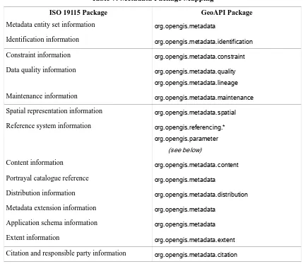
9.1 Package mapping
Table 7: Metadata Package Mapping
ISO 19115 Package GeoAPI Package
Metadata entity set information org.opengis.metadata
Identification information org.opengis.metadata.identification Constraint information org.opengis.metadata.constraint Data quality information org.opengis.metadata.quality
org.opengis.metadata.lineage
Maintenance information org.opengis.metadata.maintenance Spatial representation information org.opengis.metadata.spatial Reference system information org.opengis.referencing.*
org.opengis.parameter
(see below)
Content information org.opengis.metadata.content Portrayal catalogue reference org.opengis.metadata
Distribution information org.opengis.metadata.distribution Metadata extension information org.opengis.metadata
Application schema information org.opengis.metadata Extent information org.opengis.metadata.extent Citation and responsible party information org.opengis.metadata.citation
Several minor packages have been aggregated into the top level package. The Data quality information package has been split into two packages to separate the DQ_* types from the LI_* types. As explained next, the Reference system information has been replaced by the types from the referencing package.
9.2 Use of the GeoAPI metadata packages
The types in the GeoAPI metadata packages are primarily containers of Java String types, primitive types and other metadata types, and have been designed around providing read access to those elements. Metadata elements will be encountered in the data types from the referencing packages and the interfaces enable users to obtain the elements of the data type.
As an example, we want to print a list of all the authors for a document starting with an org.opengis.metadata.citation.Citation element.
for (ResponsibleParty rp : citation.getCitedResponsibleParties()) {
The remainder of the metadata packages work in similar ways, where client code must disaggregate an instance to obtain the elements needed.
9.3 Departures from standard
The major departure in the GeoAPI metadata packages from the published ISO 191115 standard come from GeoAPI following the ISO 19111 standard and replacing the MD_CRS type from ISO 19115 with the types in ISO 19111. The types from ISO 19111 duplicate the classes present in the metadata specification but with richer, more complete semantics. GeoAPI does not implement the following classes but substitutes a suitable replacement from the referencing packages.
Table 8: Mapping of types from the reference system information package
ISO 19115 type GeoAPI replacement
MD_ReferenceSystem org.opengis.referencing.ReferenceSystem
Note however, that the parameter package of GeoAPI and ISO 19111 is more generic than the explicit types defined in ISO 19115, handling referencing constructs in a map like structure rather than as individual, named data types.
9.4 Future work
10. Geometry packages
The GeoAPI geometry packages use the org.opengis.geometry namespace and implement the types defined in the specification from the International Organization for Standardization ISO 19107:2003 Geographic Information - Spatial schema.
The geometry packages of GeoAPI provide spatial types combining coordinates with the reference system used for those coordinates. These types implement a vector based spatial representation of elements. The geometry packages also include a sophisticated container-ship hierarchy, objects which know of their boundary, and topological data structures.
The geometry types defined in this standard include only the two simplest types in the specification along with their abstract parent interface. It is expected that the two concrete types will be instantiated through public constructors.
10.1 Defined types
GeoAPI defines a minimal set of four types from the ISO 19107 Geographic Information - Spatial schema specification, DirectPosition, Position, Envelope, and MismatchedDimensionException, because these types are needed by the referencing package.
Table 9: Mapping of types from the Coordinate geometry package
ISO 19107 type GeoAPI type
GM_Position org.opengis.geometry.coordinate.Position
DirectPosition org.opengis.geometry.DirectPostion
GM_Envelope org.opengis.geometry.Envelope
The DirectPosition type represents a single location in the anchored coordinate space defined by a CoordinateReferenceSystem. Since DirectPosition extends the Position type that interface was needed as well.
these DirectPositions might not have any meaning in physical space. For example the corners could be outside the CRS domain of validity even if the feature itself is fully inside that domain. The corner DirectPositions are acting, for convenience, as data containers for a tuple of ordinates but not as representations of an actual Position so the ordinates of the tuple must be considered independent.
GeoAPI also defines a MismatchedDimensionException Java exception. This type can be used for method calls whose parameters might be nonsensical if they do not share the same, or have the correct, dimension.
10.2 Use of the geometry packages
The usage of the data types in the geometry package of GeoAPI follow the standard rules of Java and do not warrant extended explanation here.
10.3 Departure from Standards
GeoAPI has moved the DirectPosition and Envelope types from the coordinate sub-package where they are defined in the ISO 19107 specification up to the org.opengis.geometry package due to their importance and frequency of use. Conceptually, the ISO 19107 standard considers geometric objects to be collections of DirectPositions so that data structure is used throughout the API.
10.4 Future work
11. Referencing and Parameter packages
The GeoAPI referencing and parameter packages use the org.opengis.referencing and org.opengis.parameter namespaces respectively and implement the types defined in the standard from the International Organization for Standardization ISO 19111:2007 Geographic Information - Spatial referencing by coordinates. The referencing package also includes the types describing object factories and mathematical transformation operators between reference frames defined in the standard from the Open Geospatial Consortium OGC 01-009 OpenGIS Implementation Specification: Coordinate Transformation Services from 2003.
The referencing and parameter packages of GeoAPI provide data constructs and operations for geospatial referencing and coordinate operations.
Figure 2: Components of a CRS
(after Fig.2, ISO 19111:2007)
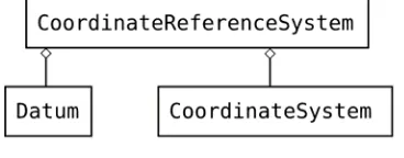
The referencing package types can be used to define geospatial referencing constructs based on the ISO 19111 specification which can be used to define various engineering and geodetic datums, define various coordinate systems, and combine those to define all the coordinate referencing systems (CRS) generally encountered in geospatial science.
Finally, the referencing packages include factory types also defined originally in the OGC 01-009 specification. These object factories define a normalized approach to object instantiation and come in two forms, the ObjectFactories which instantiate objects by assembling types passed as arguments and the AuthorityFactories which instantiate objects based on the values of some third party database, notably those in the EPSG SQL database of referencing objects assembled by the Surveying & Positioning Committee of the International Association of Oil & Gas producers.
Figure 4: Referencing factories
11.1 Package Mapping
The mapping of ISO 19111 packages to GeoAPI packages follows an almost perfectly parallel naming scheme while the OGC 01-009 packages map to GeoAPI less linearly because the factory system of the OGC standard provides factory types in each GeoAPI package.
Table 10: Referencing and Parameter Package Mapping
ISO 19111 (OGC 01-009) Package GeoAPI Package
IO Identified Object org.opengis.referencing RS Reference System org.opengis.referencing SC Coordinate Reference System org.opengis.referencing.crs CS Coordinate System org.opengis.referencing.cs
CD Datum org.opengis.referencing.datum
CC Coordinate Operation org.opengis.referencing.operation org.opengis.parameter
CS Coordinate Systems (OGC 01-009) org.opengis.referencing org.opengis.referencing.crs org.opengis.referencing.datum
CT Coordinate Transformations (OGC 01-009) org.opengis.referencing.operation PT Positioning (OGC 01-009) org.opengis.referencing.operation
Nonetheless, the mapping is fairly straightforward. It should be noted, as was discussed in the section on Metadata, that several types from the ISO 19115 specification also map into the GeoAPI referencing packages.
11.2 Use of the referencing and parameter types
The following examples illustrate the use of the referencing and parameter packages of GeoAPI.
11.2.1 Creating a Projected Coordinate Reference System
// Obtaining factory instances is implementation dependent CRSFactory crsFactory = ...;
CoordinateOperationFactory opFactory = ...; CoordinateOperationAuthorityFactory af = ...;
// We assume these instances are already available (used at end) GeographicCRS baseGeograhpicCRS = ...;
CartesianCS cartesianCS = ...;
// Get the parameters initialized to their default values
OperationMethod method = af.createOperationMethod("Mercator (1SP)"); ParameterValueGroup pg = method.getParameters().createValue();
// Set the parameter values
pg.parameter("semi-major axis").setValue(6377397.155);
pg.parameter("semi-minor axis").setValue(6377397.155 * (1 - 1/299.15281)); pg.parameter("Latitude of natural origin").setValue(0.0);
pg.parameter("Longitude of natural origin").setValue(110.0); pg.parameter("Scale factor at natural origin").setValue(0.997); pg.parameter("False easting").setValue(3900000.0);
pg.parameter("False northing").setValue(900000.0);
// Create the defining conversion
Map<String,Object> properties = new HashMap<String,Object>(); properties.put(Conversion.NAME_KEY, "Makassar / NEIEZ");
Conversion def = opFactory.createDefiningConversion(properties, method, pg);
// Create the projected CRS properties.clear();
properties.put(Conversion.NAME_KEY, "Makassar / NEIEZ"); ProjectedCRS projectedCRS = crsFactory.createProjectedCRS( properties, baseGeographicCRS, def, cartesianCS);
This gives us a ProjectedCRS with the appropriate parameters for our needs.
11.2.2 Build a Coordinate Operation
In this usage example we build an operation using a sophisticated factory.
// Obtaining factory instances is implementation dependent CoordinateOperationFactory opFactory = ...;
// We assume these instances are already available (taken from above) CoordinateReferenceSystem sourceCRS = baseGeographicCRS;
CoordinateReferenceSystem targetCRS = projectedCRS;
CoordinateOperation op = opFactory.createOperation(sourceCRS, targetCRS);
11.2.3 Transform a coordinate between coordinate reference systems.
In this example, we use the operation we just created to calculate the coordinates in a destination coordinate reference system equivalent to the coordinates in a source coordinate reference system.
// We assume these instances are already available CoordinateOperation op = ...;
double[] sourceOrdinates = ...;
// Create the destination array
double[] targetOrdinates = new double[sourceOrdinates.length];
MathTransform mt = op.getMathTransform();
mt.transform(sourceOrdinates, 0, targetOrdinates, 0,
sourceOrdinates.length / mt.getSourceDimensions());
with the user needing to guarantee that the length of the ordinate arrays are the same integer multiple of the number of dimensions in their respective coordinate reference systems.
11.3 Departure from Standards
The major departure of GeoAPI from the ISO 19111 standard comes from the inclusion, directly in the CoordinateOperation type, of a method providing access to the MathTransform construct from the older OGC specification. This departure fundamentally alters the function of these packages: under the ISO 19111 standard the classes only describe coordinate reference systems and the operations which convert between them, under GeoAPI the classes also provide an object which can actually calculate the coordinates in a destination CRS equivalent to given coordinates in a source CRS. For reasons of consistency with the OGC 01-009 approach, the method providing access to the MathTransform has been directly integrated into the CoordinateOperation interface so that users can obtain the mathematical object directly from the object that defines the operation. GeoAPI further departs in defining its own 1D and 2D MathTransforms, for speed, convenience and interoperability with the Java2D graphics library.
namespaces and the authority codes provided by the EPSG database of the Surveying & Positioning Committee of the International Association of Oil & Gas producers (OGP).
One minor departure from the ISO 19111 specification comes from GeoAPI defining an Ellipsoidal VerticalDatumType. The ISO specification does not allow distances above an ellipsoid independent of the longitude and latitude coordinates in order to prevent users from misusing the vertical ordinate during conversion. However, this separation is not inherently incorrect, but merely dangerous, and is necessary to handle older constructs such as the coordinate reference systems defined in the Well-Known Text textual format. GeoAPI has therefore elected to integrate this vertical datum type.
11.4 Future work
Annex A
(normative)
Conformance
Libraries implementing GeoAPI are enjoined to follow certain requirements to claim conformance with this standard. The standard does permit implementations with different levels of coverage of the library by providing, below, a number of conformance classes for implementation libraries.
A.1 Fundamental requirements
All implementing libraries must follow the requirements made in this clause.
Implementing libraries must satisfy all paragraphs in this standard and in the library Javadoc that use the keywords "required", "shall", "shall not", or "must".
Java libraries which provide code implementations of the GeoAPI interfaces and which wish to claim conformance with this standard shall follow the dictates both of the Javadoc comments in the API and of the language of the OGC specifications which define each Java method.
Conformant libraries shall respect the following general pattern for method return values unless countermanded by the Javadoc code documentation for a particular method. Methods which generate new instances, such as Factory methods, are expected to return the desired value or to throw a checked exception such as a FactoryException. 'Setter' methods, methods which set the value of an object, are expected either to succeed or to throw an UnsupportedOperationException if the method is either not implemented or illegal in that implementation. 'Getter' methods, methods which obtain a value from an object, are documented through annotations to the Javadoc as mandatory or optional. Mandatory 'getter' methods are expected to return the requested value unless the value is missing in which case they shall throw the runtime exception, IllegalStateException. (An exception is made to this rule in the metadata packages because of the extensive existence of incomplete metadata. In those packages, all methods are treated as optional.) Optional 'getter' methods are expected to return the requested value unless the value is missing or the method is not implemented in which case they shall return null. Exceptions to these general rules occur occasionally but are documented in the Javadoc comments.
A.2 Conformance levels
This standard provides several levels of conformance for libraries that wish to claim conformance with this standard.
All implementations must necessarily provide a fully functional implementation of the base types required by the library. This means that all implementing libraries must provide a fully working implementation of the JSR-275 standard, possibly by including the reference implementation directly. All implementing libraries must also provide functional implementations of the types defined in the org.opengis.util package.
A.2.1 Conformance Level M – Metadata
The first level of conformance, M1, requires the implementing library to provide a functional implementation of methods annotated with @Profile(level=CORE) in the org.opengis.metadata packages.
The second level of conformance, M2, requires the implementing library to provide a functional implementation of all the types defined in the org.opengis.metadata packages.
A.2.2 Conformance Level R-A – Referencing Base
Libraries implementing the types defined in the org.opengis.referencing and org.opengis.parameter packages can reach several different levels of conformance depending on the coverage and complexity of their implementation.
The simplest conformant status for the Referencing level, Status R-A1 provides code, including the ObjectFactory types, which can instantiate all the objects in the org.opengis.referencing.datum, cs, and crs packages but may be limited to the creation of coordinate referencing systems which are not compound.
The next status for this level, Status R-A2 provides the types in level R-A1 but includes all the types necessary for compound coordinate reference systems. At this conformance level, the implementation must be able to construct any CoordinateReferenceSystem which is legal under the ISO 19111 standard, including all of the projected systems.
A.2.3 Conformance Level R-B – Referencing Authority Factories
The simplest conformance status for this level, Status R-B1 requires being able to instantiate the most common objects from the OGC authority. The factory must be able to handle the following identifiers:
• CRS:1 (computer display)
• CRS:84 (geographic, WGS 84)
• CRS:83 (geographic, NAD83)
• CRS:27 (geographic, NAD27)
• CRS:88 (NAD vertical datum)
• AUTO2:42001 (Universal Transverse Mercator)
• AUTO2:42002 (Transverse Mercator)
• AUTO2:42003 (Orthographic)
• AUTO2:42004 (Equirectangular)
• AUTO2:42005 (Mollweide)
which are defined by the OGC for other implementation specifications. The factory should also be able to handle the URN form of these identifiers, such as urn:ogc:def:crs:epsg:4326, and the URL form, such as http://www.opengis.net/gml/srs/epsg.xml#4326.
The next conformance status for this level, Status R-B2 requires being able to instantiate valid instances from any Well-Known Text (WKT) string. WKT is defined in OGC 01-009.
The final conformance status for this level, Status R-B3 requires being able to instantiate a valid instances of the Datum, CoordinateSystem, or CoordinateReferenceSystem interfaces based on the codes and values in the EPSG database. The database is maintained by the Surveying and Positioning Committee of the International Association of Oil and Gas Producers and can be found at the URL http://www.epsg.org/.
A.2.4 Conformance Level R-C – Referencing Operations
This conformance level requires implementations to be able to create the types in the org.opengis.referencing.operation and org.opengis.parameter packages.
The simplest conformance status for this level, Status R-C1 requires implementations to provide the CoordinateOperationFactory type and be able to instantiate any of the types in the two packages.
A.2.5 Conformance Level R-M – Math Transforms
This conformance level requires that the CoordinateOperations provided by the implementations be able to create the appropriate MathTransform instance for the OperationMethod of the CoordinateOperation. The MathTransform will then permit the calculation of coordinates in a target coordinate reference system from the values of a coordinate in a source coordinate reference system. The different status categories for this level are distinguished by the mathematical complexity of the OperationMethod which are supported.
The first conformance status for this level, Status R-M1 requires that conformant implementations be able to instantiate the appropriate MathTransform instance for any CoordinateOperation which uses one of the OperationMethod types identified below:
• Affine general parametric transformation (EPSG:9624)
• Longitude rotation (EPSG:9601)
• Equidistant Cylindrical (EPSG:9842, 9823)
• Mercator (1SP) (EPSG:9804)
• Mercator (2SP) (EPSG:9805)
These MathTransform instances involve no shift in Datum and the most basic mathematical treatment.
The next conformance status for this level, Status R-M2, requires that conformant implementations be able to instantiate the appropriate MathTransform instance for any CoordinateOperation which uses one of the OperationMethod types identified below:
• Transverse Mercator (EPSG:9807)
• Transverse mercator (South Orientated) (EPSG:9808)
• Lambert Conic Conformal (1SP) (EPSG:9801)
• Lambert Conic Conformal (2SP) (EPSG:9802)
• Lambert Conic Conformal (2SP Belgium) (EPSG:9803)
These operations involve no shift in Datum but require more advanced mathematics.
The third conformance status for this level, Status R-M3, requires that conformant implementations be able to instantiate the appropriate MathTransform instance for any CoordinateOperation which uses one of the OperationMethod types identified below:
• Molodensky transformation (EPSG:9604)
• Abridged Molodensky transformation (EPSG:9605)
• Geographic/geocentric conversions (EPSG:9602)
• Geocentric translation (EPSG:9603)
• Position Vector 7-parameters (EPSG:9606)
These operations perform a shift in Datum but the shifts require only a small number of parameters.
The final conformance status for this level, Status R-M4 requires that conformant implementations be able to instantiate the appropriate MathTransform instance for any CoordinateOperation which uses one of the OperationMethod types identified below:
• Ellipsoid to Geoid
• North American Datum Conversion (EPSG:9613)
These operations require a shift in Datum based on an extensive set of parameters using a numerical Grid or a set of spherical harmonic parameters.
A.3 Validation
The GeoAPI source bundle, in the test packages of the conformance modules, contains a number of validator which can be used in JUnit test cases to test compliance of the objects created in an implementation. This is not as sophisticated as a full conformance test suite. Nonetheless, the GeoAPI validators can establish that certain instances are invalid and therefore can readily be integrated into the test suite of any implementation library.
A.3.1 Example of a validation test
The following code demonstrates an example which uses the validators contained in the GeoAPI binary distribution to evaluate an instance object created by the implementation within a unit test. This test would require the JUnit library, version 4 or later, on the Java Classpath.
Annex B
(normative)
GeoAPI Source Java Archive
In addition to this document, this specification includes the normative GeoAPI Java archive file:
geoapi-3.00-sources.jar
That archive contains the authoritative Javadoc code documentation for the types and methods.
The Java archive file contains the following elements:
META-INF/MANIFEST.MF
Annex C
(informative)
GeoAPI Types and Methods
This annex lists the GeoAPI identifiers (first column) together with the OGC/ISO identifiers and their originating specifications. This list includes every types and members present in the Javadoc, but without their method signature. Implementors should refer to the Javadoc for the detailed API description.
Package org.opengis.geometry
Interface DirectPosition DirectPosition ISO 19107
getCoordinateReferenceSystem coordinateReferenceSystem ISO 19107
getDimension dimension ISO 19107
getCoordinate coordinate ISO 19107
getOrdinate setOrdinate
equals Java
hashCode Java
Interface Envelope GM_Envelope ISO 19107
getCoordinateReferenceSystem getDimension
getLowerCorner lowerCorner ISO 19107
getUpperCorner upperCorner ISO 19107
getMinimum getMaximum getMedian getSpan
Class MismatchedDimensionException
Package org.opengis.geometry.coordinate
Interface Position GM_Position ISO 19107
Package org.opengis.metadata
Interface ApplicationSchemaInformation MD_ApplicationSchemaInformation ISO 19115
getName name ISO 19115
getSchemaLanguage schemaLanguage ISO 19115
getConstraintLanguage constraintLanguage ISO 19115
getSchemaAscii schemaAscii ISO 19115
getGraphicsFile graphicsFile ISO 19115
getSoftwareDevelopmentFile softwareDevelopmentFile ISO 19115 getSoftwareDevelopmentFileFormat softwareDevelopmentFileFormat ISO 19115
Code list Datatype MD_DatatypeCode ISO 19115
CLASS class ISO 19115
CODE_LIST codelist ISO 19115
ENUMERATION enumeration ISO 19115
CODE_LIST_ELEMENT codelistElement ISO 19115
ABSTRACT_CLASS abstractClass ISO 19115
CHARACTER_STRING characterString ISO 19115
INTEGER integer ISO 19115
ASSOCIATION association ISO 19115
Interface ExtendedElementInformation MD_ExtendedElementInformation ISO 19115
getName name ISO 19115
getMaximumOccurrence maximumOccurrence ISO 19115
getDomainValue domainValue ISO 19115
getParentEntity parentEntity ISO 19115
getRule rule ISO 19115
getRationales rationale ISO 19115
getSources source ISO 19115
Interface FeatureTypeList MD_FeatureTypeList ISO 19115
getSpatialObject spatialObject ISO 19115
getSpatialSchemaName spatialSchemaName ISO 19115
Interface Identifier MD_Identifier ISO 19115
getCode code ISO 19115
getAuthority authority ISO 19115
Interface Metadata MD_Metadata ISO 19115
getFileIdentifier fileIdentifier ISO 19115
getCharacterSet characterSet ISO 19115
getParentIdentifier parentIdentifier ISO 19115
getHierarchyLevels hierarchyLevel ISO 19115
getHierarchyLevelNames hierarchyLevelName ISO 19115
getContacts contact ISO 19115
getDateStamp dateStamp ISO 19115
getMetadataStandardName metadataStandardName ISO 19115 getMetadataStandardVersion metadataStandardVersion ISO 19115
getDataSetUri dataSetURI ISO 19115
getLocales locale ISO 19115
getSpatialRepresentationInfo spatialRepresentationInfo ISO 19115
getReferenceSystemInfo referenceSystemInfo ISO 19115
getMetadataExtensionInfo metadataExtensionInfo ISO 19115
getIdentificationInfo identificationInfo ISO 19115
getContentInfo contentInfo ISO 19115
getDistributionInfo distributionInfo ISO 19115
getDataQualityInfo dataQualityInfo ISO 19115
getPortrayalCatalogueInfo portrayalCatalogueInfo ISO 19115
getMetadataConstraints metadataConstraints ISO 19115
getApplicationSchemaInfo applicationSchemaInfo ISO 19115
getMetadataMaintenance metadataMaintenance ISO 19115
getAcquisitionInformation acquisitionInformation ISO 19115-2
Interface MetadataExtensionInformation MD_MetadataExtensionInformation ISO 19115
getExtensionOnLineResource extensionOnLineResource ISO 19115
getExtendedElementInformation extendedElementInformation ISO 19115
Code list Obligation MD_ObligationCode ISO 19115
MANDATORY mandatory ISO 19115
OPTIONAL optional ISO 19115
CONDITIONAL conditional ISO 19115
Interface PortrayalCatalogueReference MD_PortrayalCatalogueReference ISO 19115
getPortrayalCatalogueCitations portrayalCatalogueCitation ISO 19115
Package org.opengis.metadata.acquisition
Interface AcquisitionInformation MI_AcquisitionInformation ISO 19115-2
getAcquisitionPlans acquisitionPlan ISO 19115-2
getAcquisitionRequirements acquisitionRequirement ISO 19115-2 getEnvironmentalConditions environmentalConditions ISO 19115-2
getInstruments instrument ISO 19115-2
getObjectives objective ISO 19115-2
getOperations operation ISO 19115-2
getPlatforms platform ISO 19115-2
Code list Context MI_ContextCode ISO 19115-2
ACQUISITION acquisition ISO 19115-2
PASS pass ISO 19115-2
Interface EnvironmentalRecord MI_EnvironmentalRecord ISO 19115-2
getAverageAirTemperature averageAirTemperature ISO 19115-2
getMaxRelativeHumidity maxRelativeHumidity ISO 19115-2
getMaxAltitude maxAltitude ISO 19115-2
getMeteorologicalConditions meteorologicalConditions ISO 19115-2
Interface Event MI_Event ISO 19115-2
getIdentifier identifier ISO 19115-2
getTrigger trigger ISO 19115-2
getContext context ISO 19115-2
getSequence sequence ISO 19115-2
getTime time ISO 19115-2
getExpectedObjectives expectedObjective ISO 19115-2
getRelatedPass relatedPass ISO 19115-2
getRelatedSensors relatedSensor ISO 19115-2
Code list GeometryType MI_GeometryTypeCode ISO 19115-2
POINT point ISO 19115-2
LINEAR linear ISO 19115-2
AREAL areal ISO 19115-2
STRIP strip ISO 19115-2
Interface Instrument MI_Instrument ISO 19115-2
getCitations citation ISO 19115-2
getIdentifier identifier ISO 19115-2
getType type ISO 19115-2
getDescription description ISO 19115-2
getMountedOn mountedOn ISO 19115-2
Interface Objective MI_Objective ISO 19115-2
getIdentifiers identifier ISO 19115-2
getPriority priority ISO 19115-2
getTypes type ISO 19115-2
getFunctions function ISO 19115-2
getExtents extent ISO 19115-2
getObjectiveOccurences objectiveOccurence ISO 19115-2
getPass pass ISO 19115-2
getSensingInstruments sensingInstrument ISO 19115-2
Code list ObjectiveType MI_ObjectiveTypeCode ISO 19115-2
INSTANTANEOUS_COLLECTION instantaneousCollection ISO 19115-2
PERSISTENT_VIEW persistentView ISO 19115-2
SURVEY survey ISO 19115-2
Interface Operation MI_Operation ISO 19115-2
getDescription description ISO 19115-2
getCitation citation ISO 19115-2
getIdentifier identifier ISO 19115-2
getStatus status ISO 19115-2
getType type ISO 19115-2
getChildOperations childOperation ISO 19115-2
getObjectives objective ISO 19115-2
getParentOperation parentOperation ISO 19115-2