Posted Date: 2012-11-16
Approval Date: 2012-12-21
Publication date: 2013-03-26
External identifier of this OGC® document: http://www.opengis.net/doc/bp/eo-product-collection
Reference number of this document: OGC 11-035r1
Version: 1.0
Category: OGC® Best Practice
Editors: Frédéric Houbie, Steven Smolders
EO Product Collection, Service and Sensor Discovery
using the CS-W ebRIM Catalogue
Copyright © 2013 Open Geospatial Consortium
To obtain additional rights of use, visit http://www.opengeospatial.org/legal This document defines an OGC Best Practices on a particular technology or approach related to an OGC standard. This document is not an OGC Standard and may not be referred to as an OGC Standard. This document is subject to change without notice. This document is an official position of the OGC membership on this particular technology topic
Document type: OGC® Best Practice Paper Document subtype: NA
License Agreement
Permission is hereby granted by the Open Geospatial Consortium, ("Licensor"), free of charge and subject to the terms set forth below, to any person obtaining a copy of this Intellectual Property and any associated documentation, to deal in the Intellectual Property without restriction (except as set forth below), including without limitation the rights to implement, use, copy, modify, merge, publish, distribute, and/or sublicense copies of the Intellectual Property, and to permit persons to whom the Intellectual Property is furnished to do so, provided that all copyright notices on the intellectual property are retained intact and that each person to whom the Intellectual Property is furnished agrees to the terms of this Agreement.
If you modify the Intellectual Property, all copies of the modified Intellectual Property must include, in addition to the above copyright notice, a notice that the Intellectual Property includes modifications that have not been approved or adopted by LICENSOR.
THIS LICENSE IS A COPYRIGHT LICENSE ONLY, AND DOES NOT CONVEY ANY RIGHTS UNDER ANY PATENTS THAT MAY BE IN FORCE ANYWHERE IN THE WORLD.
THE INTELLECTUAL PROPERTY IS PROVIDED "AS IS", WITHOUT WARRANTY OF ANY KIND, EXPRESS OR IMPLIED, INCLUDING BUT NOT LIMITED TO THE WARRANTIES OF MERCHANTABILITY, FITNESS FOR A PARTICULAR PURPOSE, AND NONINFRINGEMENT OF THIRD PARTY RIGHTS. THE COPYRIGHT HOLDER OR HOLDERS INCLUDED IN THIS NOTICE DO NOT WARRANT THAT THE FUNCTIONS CONTAINED IN THE INTELLECTUAL PROPERTY WILL MEET YOUR REQUIREMENTS OR THAT THE OPERATION OF THE INTELLECTUAL PROPERTY WILL BE UNINTERRUPTED OR ERROR FREE. ANY USE OF THE INTELLECTUAL PROPERTY SHALL BE MADE ENTIRELY AT THE USER’S OWN RISK. IN NO EVENT SHALL THE COPYRIGHT HOLDER OR ANY CONTRIBUTOR OF INTELLECTUAL PROPERTY RIGHTS TO THE INTELLECTUAL PROPERTY BE LIABLE FOR ANY CLAIM, OR ANY DIRECT, SPECIAL, INDIRECT OR CONSEQUENTIAL DAMAGES, OR ANY DAMAGES WHATSOEVER RESULTING FROM ANY ALLEGED INFRINGEMENT OR ANY LOSS OF USE, DATA OR PROFITS, WHETHER IN AN ACTION OF CONTRACT, NEGLIGENCE OR UNDER ANY OTHER LEGAL THEORY, ARISING OUT OF OR IN CONNECTION WITH THE IMPLEMENTATION, USE, COMMERCIALIZATION OR PERFORMANCE OF THIS INTELLECTUAL PROPERTY.
This license is effective until terminated. You may terminate it at any time by destroying the Intellectual Property together with all copies in any form. The license will also terminate if you fail to comply with any term or condition of this Agreement. Except as provided in the following sentence, no such termination of this license shall require the termination of any third party end-user sublicense to the Intellectual Property which is in force as of the date of notice of such termination. In addition, should the Intellectual Property, or the operation of the Intellectual Property, infringe, or in LICENSOR’s sole opinion be likely to infringe, any patent, copyright, trademark or other right of a third party, you agree that LICENSOR, in its sole discretion, may terminate this license without any compensation or liability to you, your licensees or any other party. You agree upon termination of any kind to destroy or cause to be destroyed the Intellectual Property together with all copies in any form, whether held by you or by any third party.
Except as contained in this notice, the name of LICENSOR or of any other holder of a copyright in all or part of the Intellectual Property shall not be used in advertising or otherwise to promote the sale, use or other dealings in this Intellectual Property without prior written authorization of LICENSOR or such copyright holder. LICENSOR is and shall at all times be the sole entity that may authorize you or any third party to use certification marks, trademarks or other special designations to indicate compliance with any LICENSOR standards or specifications.
Abstract
This is an OGC Best Practice document describing the relations that exist between several metadata conceptual models (EO Product, EO Product Collections, Sensors and Services). The specification of the linking between different artifacts is important for the process of cataloguing and discovering those artifacts.
Keywords
Contents
1 INTRODUCTION ... 1
1.1 Document contributor contact points ... 1
1.2 Revision history ... 1
1.3 Future work ... 2
1.4 Forward ... 2
2 REFERENCES ... 2
3 TERMS AND DEFINITIONS ... 4
4 CONVENTIONS ... 5
4.1 Abbreviated terms ... 5
4.2 UML notation ... 5
5 INTRODUCTION ... 5
6 METADATA MODELS ... 7
6.1 EO Product Collection minimal information model ... 7
6.1.1 EO Product Collection information model ... 7
6.1.2 Non ISO 19115 elements for eo product collection discovery ... 14
6.2 EO Services minimal information model ... 17
6.2.1 EO Services information model ... 18
6.2.2 INSPIRE mapping notes ... 25
6.3 SensorML minimal information model ... 25
6.3.1 SensorML Discovery Profile ... 25
7 DISCOVERY STRATEGY IN EO COMMUNITY ... 26
7.1 EO Community Metadata model ... 26
7.1.1 Link between EO product metadata and the acquiring sensor ... 27
7.1.2 Link between EO product metadata and the metadata of the corresponding EO Product Collection ... 31
7.1.4 Identifier definition ... 32
7.2 Metadata cataloguing ... 32
7.2.1 How to link different extension packages in a CSW ebRIM catalog ... 33
7.2.1.1 LINK BY ASSOCIATION ... 33
7.2.1.2 LINK BY EQUIVALENT SLOT ... 33
7.2.2 Link between EO Product and EO Product Collection metadata ... 34
7.2.3 Link between EO Product and Sensor metata ... 34
List of figures
Figure 1 EO Product Collection metadata (Simplified UML class diagram – using
ISO19115 elements only – not all dataTypes/codelists included) ... 7
Figure 2 EO Product Collection metadata (Simplified UML class diagram – using ISO19115 -2 extension for Platform & Instrument elements only) ... 15
Figure 3 : EO Data Models and what they describe ... 27
List of tables
Page Table 1 Metadata entity set information (EO Product Collection Mandatory elements only) ... 8Table 2 CI_ResponsibleParty (EO Product Collection Mandatory elements only) ... 9
Table 3 DataIdentification Information (EO Product Collection Mandatory elements only) ... 10
Table 4 CI_Citation (EO Product Collection Mandatory elements only) ... 11
Table 5 CI_Date (EO Product Collection Mandatory elements only) ... 11
Table 6 MD_resolution (EO Product Collection Mandatory elements only) ... 11
Table 7 MD_Keywords ... 12
Table 8 DQ_DataQuality ... 12
Table 9 DQ_Element ... 12
Table 10 DQ_Result ... 13
Table 11 LI_Lineage ... 13
Table 12 MD_Constraints/LegalConstraints ... 14
Table 14 CI_ResponsibleParty (EO Services Collection Mandatory elements only) ... 20
Table 15 ServiceIdentification Information ... 22
Table 16 SV_CoupledResource ... 22
Table 17 SV_OperationMetadata ... 22
Table 18 MD_StandardOrderProcess ... 23
Table 19 CI_Citation ... 23
Table 20 CI_Date ... 24
Table 21 MD_Keywords ... 24
1
EO Product Collection and Service Discovery using the
CS-W ebRIM Catalogue
1 Introduction
This document is created within the SMAAD (Semantic-web Mediated Access Across Domains) project. This European Project aims at validating the technical choices concerning metadata and discovery within the Earth Observation domain made within the Heterogeneous Mission Accessibility series of projects.
This document proposes a technical guideline for implementing the discovery of EO Product Collections, EO Services and EO Sensors.
This document contains an analysis of the minimal EO Product collection and EO Services metadata that is to be supplied for meaningful and concise descriptions of EO Product Collections and EO Services and documents the effects on the existing CIM extension Package of the ebRIM Application Profile of CSW.
1.1 Document contributor contact points
All questions regarding this document should be directed to the editor or the contributors:
Name Organization
Frédéric Houbie Intergraph Philippe Mougnaud ESA Steven Smolders GIM
1.2 Revision history
Date Release Editor Primary clauses modified
Description
2011-10-06 1.0 S. Smolders,
F. Houbie
All Initial version
1.3 Future work
This document is a description of the relations that exist between different metadata models and their cataloguing process. Evolutions in the metadata models or
catalogue specifications could have impact on the content of this document.
1.4 Forward
Attention is drawn to the possibility that some of the elements of this document may be the subject of patent rights. The Open Geospatial Consortium shall not be held responsible for identifying any or all such patent rights.
Recipients of this document are requested to submit, with their comments, notification of any relevant patent claims or other intellectual property rights of which they may be aware that might be infringed by any implementation of the standard set forth in this document, and to provide supporting documentation.
2 References
The following documents provide background reference. In the body of the text these documents are referenced as listed below.
[RD01] ISO 19115:2003 Geographic Information – Metadata
[RD02] ISO 19119, Geographic Information – Services (ISO 19119:2005) 21/06/2006,
http://www.iso.org/iso/iso_catalogue/catalogue_tc/catalogue_detail.htm?cs number=39890
[RD03] ISO 19139, Geographic Information – Metadata XML (ISO 19139:2007), http://www.iso.org/iso/iso_catalogue/catalogue_tc/catalogue_detail.htm?cs number=32557
[RD04] OGC 09-163r2, OGC Catalogue Services Specification 2.0, Extension Package for ebRIM Application Profile: SensorML, Version 0.0.3, 02/04/2010.
[RD05] OGC 06-131r6, OGC Catalogue Services Specification 2.0, Extension Package for ebRIM Application Profile: Earth Observation Products, Version 1.0.0, 10/02/2010
http://portal.opengeospatial.org/files/?artifact_id=28152
[RD06] OGC 07-038r3, OGC Cataloguing of ISO Metadata (CIM) – Using the ebRIM profile of CS-W, Version 0.1.12
[RD07] OGC 07-045, OpenGIS Catalogue Services Specification 2.0.2 – ISO Metadata Application Profile, Version 1.0, 19/07/2007,
[RD08] DRAFT HMA EO Product Collection and Service Discovery using the ISO Metadata Application Profile of CSW 2.0.1, OGC 07-025 (not published)
[RD09] OGC 04-038r4 OpenGIS Catalogue Services Specification 2.0.1 (with Corrigendum) ISO Metadata Application Profile
[RD10] OGC 10-168 DRAFT, OGC SensorML Encoding Standard, Version 2.0.0, 2011-06-27
[RD11] ISO 19115/Cor.1:2006, Geographic information – Metadata, Technical Corrigendum 1
[RD12] INSPIRE Metadata Implementing Rules: Technical Guidelines based on EN ISO 19115 and EN ISO 19119, INSPIRE Drafting Team Metadata and European Commission Joint Research Centre, V. 1.2, 2010-06-16
[RD13] ISO 19119:2005/PDAM 1 - Extensions of the service metadata model http://www.iso.org/iso/iso_catalogue/catalogue_tc/catalogue_detail.htm?cs number=44268
[RD14] INSPIRE Metadata Regulation, 03/12/2008, COMMISSION
REGULATION (EC) No 1205/2008 of 3 December 2008 implementing Directive 2007/2/EC of the European Parliament and of the Council as regards metadata, http://eur-
lex.europa.eu/LexUriServ/LexUriServ.do?uri=CELEX:32008R1205:EN:N OT
[RD15] Corrigendum to INSPIRE Metadata Regulation 15.12.200, Corrigendum to INSPIRE Metadata Regulation published in the Official Journal of the European Union, L 328, page 83, http://eur-
lex.europa.eu/LexUriServ/LexUriServ.do?uri=CELEX:32008R1205R%28 02%29:EN:NOT
[RD16] ISO 19115-2:2009 - Geographic information -- Metadata -- Part 2: Extensions for imagery and gridded data
[RD17] ISO 19139-2, Geographic Information – Metadata – XML Schema Implementation – Part 2: Extensions for imagery and gridded data – DRAFT
[RD18] OGC 11-043 DRAFT, Sensor Model Language 2.0 Extensions for Earth Observation Instruments and Platforms, Version: 1.0.0, 2011-04-15
[RD19] OGC 08-167 Semantic Annotation of OGC standards, Version 2.1 2011-07-27
[RD20] OGC 10-157 Earth Observation Metadata profile of Observations & Measurements, Version 1.0.0, 2011-06-02
3 Terms and definitions
dataset
identifiable collection of data (ISO19115)
dataset series
collection of datasets sharing the same product specification (ISO19115)
EO product collection
An EO product collection is equivalent to a dataset series as defined within the ISO 19XXX series of standards. It is a collection of datasets sharing the same product specification.
In the Earth Observation context, a collection typically corresponds to datasets (i.e. products) derived from data acquired by a single sensor onboard a satellite or series of satellites and having the same operation mode. Examples of EO Product
Collections are “TerraSAR-X spotlight mode ” or “ESA ENVISAT MERIS Full Resolution L1+2”
EO Service
Web Service that operates on the above mentioned EO product collections.
Examples of such services include catalogue services that allow discovery of EO data products, EO Product Collections, EO Sensors and EO Services, EO Feasibility Analysis services, EO Ordering services, on-line EO data access services and EO Web Map Services.
interface
named set of operations that characterize the behaviour of an entity (ISO19119)
metadata
data about data (ISO19115)
metadata element
discrete unit of metadata (ISO19115)
metadata entity
set of metadata elements describing the same aspect of data (ISO19115)
model
abstraction of some aspects of a universe of discourse (ISO19115)
operation
specification of a transformation or query that an object may be called to execute (ISO19119)
resource
service
distinct part of the functionality that is provided by an entity through interfaces ([ISO/IEC TR 14252])
service interface
shared boundary between an automated system or human being and another automated system or human being [ISO 19101]
4 Conventions
4.1 Abbreviated terms
AP Application Profile
CIM Cataloguing of ISO Metadata
CSW Catalogue Services for the Web
DLR Deutsches Zentrum für Luft- und Raumfahrt
ebRIM eBusiness Registry Information Model
EO Earth Observation
ESA European Space Agency
HMA Heterogeneous Missions Accessibility
INSPIRE Infrastructure for Spatial Information in Europe
ISO International Organisation for Standardisation
OGC Open Geospatial Consortium
TBC To Be Confirmed
TBD To Be Defined
UML Unified Modelling Language
XML eXtensible Markup Language
4.2 UML notation
Most diagrams that appear in this standard are presented using the Unified
Modeling Language (UML) static structure diagram, as described in Subclause 5.2 of [OGC 06-121r3].
5 Introduction
This EO Production Collection metadata information model was based on the ISO 19115 metadata model which was adapted for use in the EO/HMA Context in the following manner:
It was constrained by making some optional ISO1915 elements mandatory (e.g. fileIdentifier)
It was constrained by fixing the values for some elements (e.g. hierarchyLevel fixed to series).
6 Metadata models
6.1 EO Product Collection minimal information model
6.1.1 EO Product Collection information model
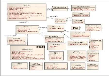
The following simplified UML class diagram shows the metadata elements that are minimally required for describing EO Product Collections. Other elements as permitted by ISO19115 may be added to obtain a more complete description:
Figure 1 EO Product Collection metadata (Simplified UML class diagram – using ISO19115 elements only – not all dataTypes/codelists included)
The following tables constitute the data dictionary. It only lists the mandated metadata elements with the changes and additional constraints with respect to ISO19115 indicated in Bold.
The contents of the INSPIRE column indicates whether this is one of the metadata elements mandated by INSPIRE and gives the INSPIRE Metadata Element name as well as the reference to the paragraph of the Implementing Rule.
Name / Role
MI_Metadata root entity which defines metadata about a resource or resources
M 1 Following
lines in this table fileIdentifier unique identifier for this
metadata file
Clarification for EO Product Collection metadata:
This fileiIdentifier is equal to the identifier of the EO Product Collection
M 1 Free text
language language used for documenting metadata
characterSet full name of the character coding standard used for the metadata set
M 1 MD_Character
SetCode <<CodeList>>
hierarchyLevel scope to which the metadata applies.
name of the hierarchy level for which the metadata is provided.
M 1 Fixed value
“EO Product Collection”
contact party responsible for the EO Product Collection dateStamp date that the metadata was
created profile name) used
M 1 Fixed value of
OGC 11-035
metadataStand ardVersion
version of the metadata standard
(version of the profile) used
M 1 Free text
Role name: identificationInf o
basic information about the resource(s) to which the metadata applies
M 1 MD_DataIdent
ification
Role name: contentInfo
describes the coverage and image data characteristics
O 1 MD_ContentIn
provides an overall assessment of quality of a
Table 1 Metadata entity set information (EO Product Collection Mandatory elements only)
Name / Role
name Definition Obligation/ Condition Maximum occurrence Domain INSPIRE
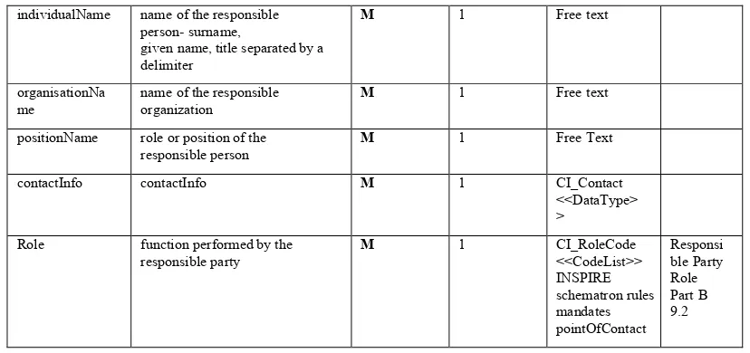
CI_Responsible Party
identification of, and means of communication with, person(s) and organizations associated with the dataset
individualName name of the responsible person- surname,
given name, title separated by a delimiter
M 1 Free text
organisationNa me
name of the responsible organization
M 1 Free text
positionName role or position of the responsible person
M 1 Free Text
contactInfo contactInfo M 1 CI_Contact
<<DataType> >
Role function performed by the responsible party
Table 2 CI_ResponsibleParty (EO Product Collection Mandatory elements only)
Name / Role
name Definition Obligation/ Condition Maximum occurrence Domain INSPIRE
MD_Identification
citation citation data for theresource(s) M 1 CI_Citation<<D ataType>>
abstract brief narrative summary ofthe content of the resource(s)
M 1 Free text Part B1.2
Resource Abstract
language language(s) used within thedataset pointOfContact identification of, and
meansof communication with, person(s) andorganization(s) associated with the resource(s)
M N CI_Responsible
Party<<DataTy
Reference to an image that illustrates the EO Product Collection. aboutconstraints whichapply to the resource(s)
M 1 MD_Constraint
s type, and reference source
1 compositeType is stored in ISO19115 using Keywords of Type Temporal that identifies a identifies a time
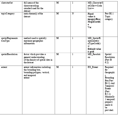
characterSet full name of the charactercoding standard used for the dataset
M 1 MD_CharacterS
etCode<<Code List>>
topicCategory main theme(s) of the dataset
method used to spatially represent geographic spatialResolution factor which provides a
general understanding of the density of spatial data in the dataset
extent extent information including the bounding box,
bounding polygon, vertical, and temporal
Table 3 DataIdentification Information (EO Product Collection Mandatory elements only)
Name / Role
name Definition Obligation/ Condition Maximum occurrence Domain INSPIRE
CI_Citation standardized resource reference
date reference date for the cited resource
Both creation and revision dates should be included
M N CI_Date Date of
title Name by which the cited
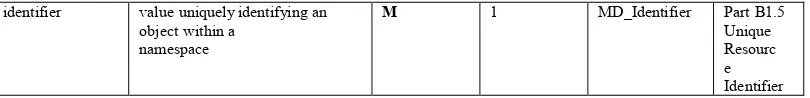
resource is known M 1 Free Text Part B1.1 Resourc
identifier value uniquely identifying an object within a
namespace
Table 4 CI_Citation (EO Product Collection Mandatory elements only)
Name / Role
Name Definition Obligation/ Condition Maximum occurrence Domain INSPIRE
CI_Date reference date and event used to describe it
Use date reference date for the cited
resource M
1 CI_Citation
<<DataType>>
dateType event used for reference date M 1 CI_DateType
Code <<CodeList>> Creation, revision and publication
Table 5 CI_Date (EO Product Collection Mandatory elements only)
Name / Role
Name Definition Obligation/ Condition Maximum occurrence Domain INSPIRE
MD_Resolution level of detail expressed as a ground distance
distance ground sample distance M 1 Distance
(ISO/TS 19103)
Table 6 MD_resolution (EO Product Collection Mandatory elements only)
Name / Role
Name Definition Obligation/ Condition Maximum occurrence Domain INSPIRE
MD_Keywords2 keywords, their type and
reference source Use obligation from keyword3 commonly used word(s) or
formalised word(s)
or phrase(s) used to describe the subject
For INSPIRE the use of one keyword expressing the INSPIRE Data theme is required. Relevant INSPIRE data themes concerning EO Product collections are “Land cover” and “Orthoimagery”
M N Free Text Part B
3.1
2 See INSPIRE metadata technical guidance for description on how to use the descriptive keywords to encode
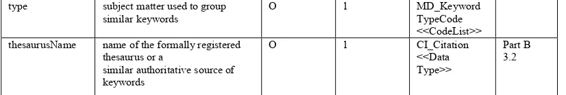
type subject matter used to group
similar keywords O 1 MD_Keyword TypeCode
<<CodeList>> thesaurusName name of the formally registered
thesaurus or a
similar authoritative source of keywords
Table 7 MD_Keywords
Name / Role
Name Definition Obligation/ Condition Maximum occurrence Domain INSPIRE
DQ_DataQualit y
quality information for the data specified by a
data quality scope
Use Scope the specific data to which the
data quality information applies
M 1 DQ_Scope
Role name:
Report
quantitative quality information for the data
specified by the scope
M 1 DQ_Element Required information about the
lineage of the data specified by the scope
M 1 LI_Lineage Required
for Part B 6.1
Table 8 DQ_DataQuality
Name / Role
Name Definition Obligation/ Condition Maximum occurrence Domain INSPIRE
DQ_Element aspect of quantitative quality
information Use obligation
from Result value (or set of values)
obtained from applying a data quality measure or the outcome of
evaluating the obtained value (or set of
values) against a specified acceptable
conformance quality level
M N DQ_Result Required
for Part B7.1/B7. 2
Table 9 DQ_Element
Name / Role
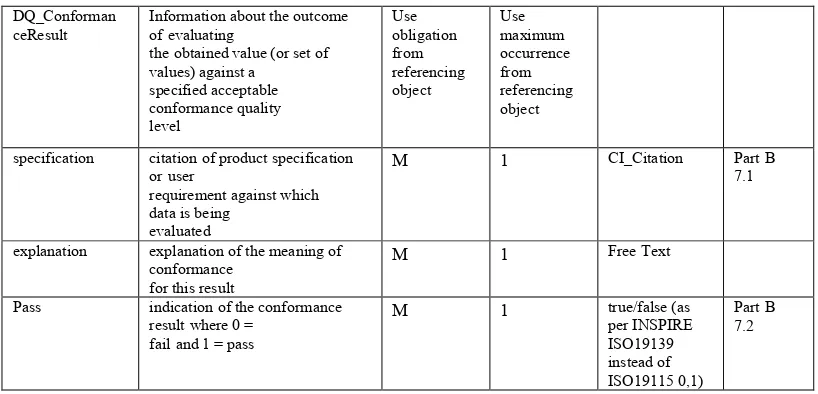
Name Definition Obligation/ Condition Maximum occurrence Domain INSPIRE
DQ_Result generalization of more specific
result classes Use obligation from
DQ_Conforman
ceResult Information about the outcome of evaluating the obtained value (or set of values) against a
specified acceptable
specification citation of product specification or user
requirement against which data is being
evaluated
M 1 CI_Citation Part B
7.1
explanation explanation of the meaning of conformance
for this result
M 1 Free Text
Pass indication of the conformance result where 0 =
Table 10 DQ_Result
Name / Role
Name Definition Obligation/ Condition Maximum occurrence Domain INSPIRE LI_Lineage information about the events or
source data
used in constructing the data specified by the
scope or lack of knowledge about lineage statement general explanation of the data
producer’s
knowledge about the lineage of a dataset
M 1 Free Text Part B
6.1
LI_ProcessStep.de scription
information about an event or transformation in the life of a dataset including the process used to maintain the d ataset
C as statement is provided
N Free Text
Table 11 LI_Lineage
Name / Role
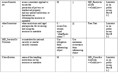
name Definition Obligation/ Condition Maximum occurrence Domain INSPIRE MD_Constraints restrictions on the access and
use of a
resource or metadata
Use useLimitation limitation affecting the fitness
for use of the resource or metadata. Example, “not to be used for navigation”
M 1 Free Text Condition
accessConstrai
nts access constraints applied to assure the protection of privacy or intellectual property, and any special restrictions or limitations on
obtaining the resource or metadata
M 1 MD_Restrictio
nCode
s other restrictions and legal prerequisites for accessing and using the
resource or metadata
C /
N Free Text Limitatio
ns on
Nstraints or metadata for national security or similar security concerns Classification name of the handling
restrictions on the resource or metadata
M 1 MD_Classifica
Table 12 MD_Constraints/LegalConstraints
6.1.2 Non ISO 19115 elements for eo product collection discovery
In addition to the ISO19115 subset described above, [RD08] also defined a set of metadata elements for EO Product Collection Discovery that could not be directly mapped on ISO19115. That information can be described in other metadata documents, like a sensorML XML file. ISO19115:2003 does not have a generic metadata element to provide additional documentation, but define a rather precise structure of metadata elements with well-defined semantic.
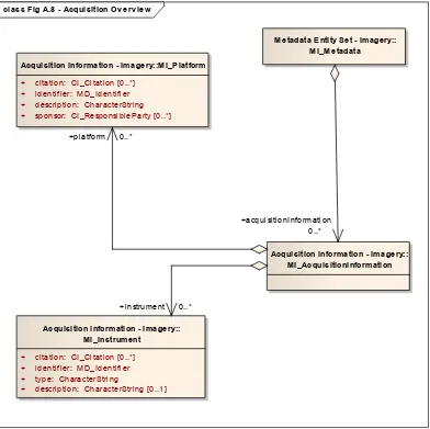
class Fig A.8 - Acquisition Ov erv iew
Metadata Entity Set - Imagery:: MI_Metadata
Acquisition information - Imagery:: MI_AcquisitionInformation Acquisition information - Imagery::MI_Platform
+ citation: CI_Citation [0..*] + identifier: MD_Identifier + description: CharacterString + sponsor: CI_ResponsibleParty [0..*]
Acquisition information - Imagery:: MI_Instrument
+ citation: CI_Citation [0..*] + identifier: MD_Identifier + type: CharacterString
+ description: CharacterString [0..1]
+acquisitionInformation 0..*
+instrument 0..* +platform 0..*
Figure 2 EO Product Collection metadata (Simplified UML class diagram – using ISO19115 -2 extension for Platform & Instrument elements only)
PropertyName Proposed
Cardinality Description Potential mapping on ISO19115 Potential mapping on ISO 19115-2
platformShortName 1 Platform short of the platform which is specified via the
“gml:identifier” property of the SensorML System in the form of a URI. TBD if the identifier or the corresponding shortname property is used for making the link. platformSerialIdentifier 0..1 Platform serial
identifier (ex. for PHR : 1A)
To be combined with Shortname in the
aforementioned code element
To be combined with Shortname in the
aforementioned code element?
instrumentShortName4 1 Instrument /
Sensor name property of the SensorML System which is specified in the form of a URI.
The most relevant observations are:
The distinction that is made between the platformShortName and
platformSerialIdentifier does not map well on ISO19115-2 and SensorML. Both properties should be combined to obtain a unique identification of a platform instance
For cross-model linkage it is better to use identifiers than shortnames for identifying platforms and instruments
In Earth Observation domain, an Instrument can be configured with specific parameters. It can be seen as a customization of a generic Instrument for a specific usage. In SensorML, this is described as a specific System (called Instrument Mode) referencing the generic Instrument ID.
<sml:SensorML
xmlns:sml="http://www.opengis.net/sensorML/1.0.1" xmlns:swe="http://www.opengis.net/swe/1.0.1" xmlns:gml="http://www.opengis.net/gml"
xmlns:xsi="http://www.w3.org/2001/XMLSchema-instance" xmlns:xlink="http://www.w3.org/1999/xlink"
xsi:schemaLocation="http://www.opengis.net/sensorML/1.0.1
<sml:System gml:id="SPOT5_HRG_PA-XS">
<!-- ================================================= --> <!-- System Description --> <!-- ================================================= --> <gml:description>
The PA+XS mode is used to acquire 5m resolution multispectral images by pan sharpening
the 10m resolution multispectral data with the 5m resolution
The processing information could potentially be added in an unstructured manner within a single descriptive field LI_ProcessStep.description of ISO19115. The ISO19115-Part 2 provided LE_ProcessStep provides additional fields to better structure the processing information
6.2 EO Services minimal information model
During the Heterogeneous Missions Accessibility Project series of ESA, the HMA stakeholders also defined the minimal set of metadata elements that are required to describe the different Web Service Instances that are being
deployed throughout the Ground Segments of the GMES Contributing Missions.
Product Collections and EO Services, Ordering Services, Feasibility Analysis, Web Map Services and Web Coverage Services.
The information model employed was based on the ISO 19119 metadata model which was adapted for use in the EO Context in the following manner:
a number of optional elements are not included in this minimum element set. These elements mainly relate to the chaining of operations and the parameters that are associated with the operations.
a number of optional elements have been declared mandatory. It is to note that the original document defined a set of minimal elements required for EO Service discovery hereby not excluding the use of additional optional ISO19119 metadata elements for obtaining a more complete
description of EO Services.
The information model proposed in this section started from the information model proposed in OGC07-025 but applies the following changes:
Using the latest corrigenda: ISO 19119:2005, Amendment 1 [RD13]. With the adoption of the INSPIRE Directive and the INSPIRE Metadata
Implementing Rules, it is desirable for EO Services metadata to contain all the minimal information elements required by the INSPIRE Metadata Implementing Rule and following the INSPIRE technical guidelines. The Elements mandated by INSPIRE have been added to the minimal set of ISO19119 elements.
Minor corrections to elements occurring in the original table.
6.2.1 EO Services information model
Figure 2 EO Services Minimal Information Model
The following tables constitute the data dictionary. The tables are based on the corresponding ISO19115/19119 tables with changes/additional constraints with respect to ISO19119 are highlighted in Bold.
The contents of the INSPIRE column indicates whether this is one of the metadata elements mandated by INSPIRE and gives the INSPIRE Metadata Element name as well as the reference to the paragraph of the Implementing Rule.
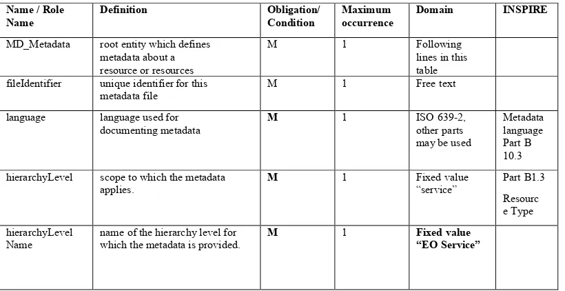
Name / Role
Name Definition Obligation/ Condition Maximum occurrence Domain INSPIRE MD_Metadata root entity which defines
metadata about a resource or resources
M 1 Following
lines in this table fileIdentifier unique identifier for this
metadata file M 1 Free text
language language used for
documenting metadata M 1 ISO 639-2, other parts may be used
Metadata language Part B 10.3 hierarchyLevel scope to which the metadata
applies. M 1 Fixed value “service” Part B1.3
Resourc e Type
hierarchyLevel Name
name of the hierarchy level for which the metadata is provided.
M 1 Fixed value
contact party responsible for the EO
Service M 1 CI_Responsibl eParty
<<DataType> dateStamp date that the metadata was
created M 1 Date Metadata date
Part B10.2
metadataStand ardName1
name of the metadata standard (including profile name) used
M 1 Fixed value of
OGC 11-035
metadataStand
ardVersion version of the metadata standard (version of the profile) used
M 1 Free text
Role name: identificationInf o
basic information about the resource(s) to
which the metadata applies
M 1 SV_ServiceId
entification
Role name dataQualityInfo
provides overall assessment of quality of a resource(s)
M N DQ_DataQuali
Table 13 Metadata entity set information (EO Services Mandatory elements only)
Name / Role
Name Definition Obligation/ Condition Maximum occurrence Domain INSPIRE
CI_Responsible
Party identification of, and means of communication with, person(s) and
organizations associated with the dataset
M 1
individualName name of the responsible person- surname,
given name, title separated by a delimiter
M 1 Free text
organisationNa
me name of the responsible organization M 1 Free text
positionName role or position of the
responsible person M 1 Free Text
contactInfo contactInfo M 1 CI_Contact
<<DataType> >
Role function performed by the
responsible party M 1 CI_RoleCode <<CodeList>> Responsi ble Party Role Part B 9.2
Table 14 CI_ResponsibleParty (EO Services Collection Mandatory elements only)
Name / Role
Name Definition Obligation/ Condition Maximum occurrence Domain INSPIRE
MD_Identification
Citation citation data for the
resource(s) M 1 CI_Citation <<DataType
>> abstract brief narrative summary of
pointOfContact identification of, and means of communication with, person(s) and organization(s) associated with the resource(s)
M 1 CI_Responsi
provides information about constraints which apply to the resource(s)
M N MD_Constrai
provides category keywords, their type, and
reference source
M N MD_Keywor
ds Required for Parts B 3.1 and B.3.2 Extent the geographic/temporal
region where the service is valid. including the bounding box, bounding polygon, vertical, or temporal extent of the service
C/ if couplingT ype equals “mixed” or "tight"
1 EX_Extent Required
for
accessProperties Information about the availability of the service, including, - Fees
- Planned available date and time
- Ordering instructions - Turnaround
O 1 MD_Standar
dOrderProce ss
restrictions Legal and security constraints on accessing the service and distributing data generated by the service.
O 1 MD_Constrai
nts
serviceType A service type name from a registry of
services. For example, the values of the
nameSpace and name attributes of
GeneralName may be "OGC " and
n Provides for searching based on the version of serviceType. For example, we may only be interested in OGC Catalogue V1.1 services. If version is maintained as a
separate attribute, users can easily search for
all services of a type regardless of the version.
O N Free Text
coupledResource further description of the data coupling in the case of tightly coupled services
O N SV_CoupledRe
couplingType type of coupling between service and associated data (if exists)
containsOperations Provides information about the operations that comprise the service
M N SV_Operatio
nMetadata
Role name:
operatesOn Provides information on the datasets that the service operates on
O N MD_DataIde
ntification Coupled Resource Part B 1.6
Implement ed by Reference
Table 15 ServiceIdentification Information
Name / Role
Name Definition Obligation/ Condition Maximum occurrence Domain INSPIRE
SV_CoupledReso
urce further description of the data coupling in the case of tightly coupled services
operationName name of the service
operation M 1 Free Text
identifier name of the identifier of a given tightly coupled dataset
M 1 Free Text
scopedName e.g. the name of the layer in the WMS or the featureTypeName of the WFS
M 1 Free text
Table 16 SV_CoupledResource
Name / Role
Name Definition Obligation/ Condition Maximum occurrence Domain INSPIRE
SV_OperationMet
adata describes the signature of one and only one method provided by the service.
operationName name of the service operation
M 1 Free Text
DCP Distributed Computing
Platforms on which
the operation has been implemented
M N DCPList
operationDescription Free text description of the intent of the
operation and the results of the operation.
M 1 Free Text
connectPoint Handle for accessing the
service interface M N CI_OnlineRe source
Table 17 SV_OperationMetadata
Name / Role
MDStandardORde
rProcess describes the signature of one and only one method provided by the service.
Fees fees and terms for retrieving the resource.
Include monetary units
M 1 Free Text
orderingInstructions general instructions, terms and services
provided by the distributor
0 1 Free Text
Table 18 MD_StandardOrderProcess
Name / Role
Name Definition Obligation/ Condition Maximum occurrence Domain INSPIRE
MDIdentifier value uniquely identifying an object within a
namespace
authority person or party responsible for maintenance
of the namespace
O 1 CI_Citation
Code alphanumeric value
identifying an instance in the namespace
M 1 Free Text
Name / Role
Name Definition Obligation/ Condition Maximum occurrence Domain INSPIRE
CI_Citation standardized resource reference
Date reference date for the cited resource
Both creation and revision dates should be included
M N CI_Date Date of
title Name by which the cited
resource is known M 1 Free Text Resourc Part B1.1
e title identifier value uniquely identifying an
object within a namespace
Table 19 CI_Citation
Name / Role
CI_Date reference date and event used
to describe it Use obligation/c ondition Date reference date for the cited
resource M 1 CI_Citation <<DataType>
>
dateType event used for reference date M 1 CI_DateType
Code <<CodeList>> Creation, revision and publication
Table 20 CI_Date
Name / Role
Name Definition Obligation/ Condition Maximum occurrence Domain INSPIRE
MD_Keywords5 keywords, their type and
reference source Use obligation from keyword6 commonly used word(s) or
formalised word(s)
or phrase(s) used to describe the subject
M N Free Text Part B
3.1
Type subject matter used to group
similar keywords O 1 MD_Keyword TypeCode
<<CodeList>> thesaurusName name of the formally registered
thesaurus or a
similar authoritative source of keywords
O 1 CI_Citation
<<Data Type>>
Part B 3.2
Table 21 MD_Keywords
Name / Role
Name Definition Obligation/ Condition Maximum occurrence Domain INSPIRE MD_Constraints restrictions on the access and
use of a
resource or metadata
Use useLimitation limitation affecting the fitness
for use of the resource or metadata. Example, “not to be used for navigation”
M 1 Free Text Condition
5 One of the keywords used should indicate the spatial data service type
MD_LegalConst
Raints restrictions and legal prerequisites for accessing and using the resource or metadata
nts access constraints applied to assure the protection of privacy or intellectual property, and any special restrictions or limitations on
M 1 MD_Restrictio
nCode obtaining the resource or
metadata otherConstraint
s Other restrictions and legal prerequisites for accessing and using the resource or metadata
N Free Text Limitatio
ns on
nstraints or metadata for national security or similar security concerns classification name of the handling
restrictions on the resource or metadata
M 1 MD_Classifica
Table 22 MD_Constraints/LegalConstraints
6.2.2 INSPIRE mapping notes
The table in section Error! Reference source not found. includes mapping notes for EO Services.
6.3 SensorML minimal information model
6.3.1 SensorML Discovery Profile
The SensorML data model specifies a majority of its elements as optional. It allows expressing the same information in several, differently structured ways. This open and flexible structure was one of the main aims of the SensorML design in order to make it possible to apply the data model to nearly any type of sensor. For ensuring that SensorML documents which are intended for discovery purposes can be
reliably handled by automatic harvesting mechanisms, it is necessary to create a profile for SensorML that define the information which shall be contained in a SensorML document as well as the structure in which the metadata shall be
encoded. This profile called Discovery Profile of SensorML is currently specified in the OGC document 09-163r2, SensorML Extension Package for ebRIM.
To constrain the flexibility of the SensorML data model, a set of Schematron rules have been defined. These rules check that the mandatory information are present in an instance of SensorML (System or Component).
- gml:description
- keywords
- Identification
o urn:ogc:def:identifier:OGC:1.0:uniqueID
o urn:ogc:def:identifier:OGC:1.0:longName
o urn:ogc:def:identifier:OGC:1.0:shortName
o parentSystemUniqueID
- Classification
o intendedApplication [urn:ogc:def:classifier:OGC:1.0:application]
o sensorType [urn:ogc:def:classifier:OGC:1.0:sensorType]
- validTime
- Capabilities
o observedBBOX
- contact
- position
- Inputs
- Outputs
- Components
The most important elements are the uniqueID and the shortName, as they are used to make the link between the different entities involved (EO Series, sensors, EO Product).
7 Discovery strategy in EO Community
7.1 EO Community Metadata model
Figure 3 : EO Data Models and what they describe
7.1.1 Link between EO product metadata and the acquiring sensor
Each EO Product described using the Earth Observation Metadata profile of Observations & Measurements [RD20] contains an EarthObservationEquipment section grouping information about the platform, instrument and sensor used to produce this EO product. SensorML defines all the information about platform, instrument and sensor. So there clearly is a conceptual relationship between EO Product and Sensors. But with the current metadata model, there is currently no definition on how to express this linkage between an EO Product (EO GML) and a SensorML.
A snippet of the eop:EarthObservationEquipment of an EO Product taken by the SPOT-4 platform using the instrument HRVIR-Nb2 is given here:
<eop:EarthObservationEquipment> <eop:platform>
<eop:Platform>
<eop:shortName>SPOT</eop:shortName> <eop:serialIdentifier>4</eop:serialIdentifier> <eop:orbitType>LEO</eop:orbitType> </eop:Platform>
</eop:platform> <eop:instrument> <eop:Instrument>
<eop:shortName>HRVIR-Nb2</eop:shortName> </eop:Instrument>
</eop:instrument> <eop:sensor> <eop:Sensor>
</eop:Sensor> </eop:sensor>
…
<eop:EarthObservationEquipment>
A snippet of a SensorML describing the Spot 4 platform is given below. The unique Identifier « urn:ogc:id:CEOS:platform:SPOT4:v01», the shortName
« SPOT4 » and the sensor type « Satellite » in the platform codespace « urn:ogc:def:dictionary:CEOS:eop:PlatformTypes:v01» are present.
<sml:SensorML version="1.0.1"> <sml:member>
<sml:System gml:id="SPOT4">
<gml:description>…</gml:description>
<!-- ================================================= --> <!-- System Identifiers -->
<!-- ================================================= --> <sml:identification>
<sml:IdentifierList>
<sml:identifier name="uniqueID">
<sml:Term definition="urn:ogc:def:identifier:OGC:1.0:uniqueID"> <sml:value>urn:ogc:id:CEOS:platform:SPOT4:v01</sml:value> </sml:Term>
</sml:identifier>
<sml:identifier name="shortName">
<sml:Term definition="urn:ogc:def:identifier:OGC:1.0:shortName"> <sml:value>SPOT4</sml:value>
</sml:Term> </sml:identifier> …
</sml:IdentifierList> </sml:identification>
<!-- ================================================= --> <!-- System Classifiers -->
<!-- ================================================= --> <sml:classification>
<sml:ClassifierList>
<sml:classifier name="sensorType">
<sml:Term definition="urn:ogc:def:classifier:OGC:1.0:sensorType">
<sml:codeSpace xlink:href="urn:ogc:def:dictionary:CEOS:eop:PlatformTypes:v01"/> <sml:value>Satellite</sml:value>
</sml:Term> </sml:classifier> …
</sml:ClassifierList> </sml:classification>
…
A snippet of a SensorML instance describing the SPOT-4 HRVIR1 instrument is given below. The unique Identifier
« urn:ogc:id:CEOS:instrument:SPOT4:HRVIR1:v01», the shortName « SPOT-4 HRVIR1» and the sensor type « Imaging Multispectral Radiometer» in the instrument codespace « urn:ogc:def:dictionary:CEOS:eop:InstrumentTypes:v01» are present.
<sml:SensorML version="1.0.1"> <sml:member
<sml:System gml:id="SPOT4_HRVIR">
<!-- ================================================= --> <!-- System Description -->
<!-- ================================================= --> <gml:description>…</gml:description>
<!-- ================================================= --> <!-- System Identifiers -->
<!-- ================================================= --> <sml:identification>
<sml:IdentifierList>
<sml:identifier name="uniqueID">
<sml:Term definition="urn:ogc:def:identifier:OGC:1.0:uniqueID">
<sml:value>urn:ogc:id:CEOS:instrument:SPOT4:HRVIR1:v01</sml:value> </sml:Term>
</sml:identifier>
<!-- <sml:identifier name="Platform UID">
<sml:Term definition="urn:ogc:def:property:CEOS:eop:PlatformID"> <sml:value>urn:ogc:id:CEOS:platform:SPOT4:v01</sml:value> </sml:Term>
</sml:identifier>
--> <sml:identifier name="shortName">
<sml:Term definition="urn:ogc:def:identifier:OGC:1.0:shortName"> <sml:value>SPOT-4 HRVIR1</sml:value>
</sml:Term> </sml:identifier> …
<sml:identifier name="parentSystemUniqueID">
<sml:Term definition="urn:ogc:def:identifier:OGC:1.0:parentSystemUniqueID"> <sml:value>urn:ogc:id:CEOS:platform:SPOT4:v01</sml:value>
</sml:Term> </sml:identifier> </sml:IdentifierList> </sml:identification>
<!-- ================================================= --> <!-- System Classifiers -->
<!-- ================================================= --> <sml:classification>
<sml:ClassifierList>
<sml:classifier name="sensorType">
<sml:Term definition="urn:ogc:def:classifier:OGC:1.0:sensorType">
<sml:codeSpace xlink:href="urn:ogc:def:dictionary:CEOS:eop:InstrumentTypes:v01"/> <sml:value>Imaging Multispectral Radiometer</sml:value>
</sml:Term> </sml:classifier>
<sml:classifier name="intendedApplication">
</sml:Term> </sml:classifier>
<sml:classifier name="Acquisition Method">
<sml:Term definition="urn:ogc:def:property:OGC:sensorType"> <sml:codeSpace
xlink:href="urn:ogc:def:dictionary:CEOS:eop:AcquisitionMethods:v01"/> <sml:value>Pushbroom</sml:value>
</sml:Term> </sml:classifier> </sml:ClassifierList> </sml:classification>
To express the linkage between EO Product metadata and the acquiring platform and sensor, we need to add the unique identifier of the platform, the instrument and perhaps the detector to the EOProduct metadata. Unfortunately, in the current version of OGC10-157 there are no elements to store these identifiers.
The long term solution is to add a new “identifier” element in the “eop:platform”, “eop:instrument” and “eop:sensor”. This solution would break backward
compatibility.
Another solution that can be realized with the current version of OGC10-157, is to use the eop:platform:shortName and eop:instrument:shortName to make the linkage and fill them with the appropriate SensorML shortName. Note that this means that the platform shortname should include the platform serial identifier.
Here is the previous EO Product snippet updated to use the same platform and instrument short name.
<eop:EarthObservationEquipment> <eop:platform>
<eop:Platform>
<eop:shortName>SPOT4</eop:shortName> <eop:serialIdentifier>4</eop:serialIdentifier> <eop:orbitType>LEO</eop:orbitType> </eop:Platform>
</eop:platform> <eop:instrument> <eop:Instrument>
<eop:shortName>SPOT-4 HRVIR1</eop:shortName> </eop:Instrument>
</eop:instrument> <eop:sensor> <eop:Sensor>
<eop:sensorType>OPTICAL</eop:sensorType> </eop:Sensor>
</eop:sensor> …
7.1.2 Link between EO product metadata and the metadata of the corresponding EO Product Collection
The link between an EO Product and the corresponding dataset series is done using the “parentIdentifier” element. The “parentIdentifier” contains the identifier
(element fileIdentifier) of the dataset series.
Here is a snippet of the “parentIdentifier” of the EO Product.
<opt:EarthObservation version="1.2.1"> <gml:metaDataProperty>
<eop:EarthObservationMetaData>
<eop:identifier>urn:spot:sn:19336775:sat:Shift0:eop</eop:identifier> <eop:doi>urn:spot:sn:19336775:sat:Shift0:eop</eop:doi>
<eop:parentIdentifier>urn:ogc:def:EOP:ESA:EECF.ENVISAT_ASA_APx_xS </eop:parentIdentifier>
…
</eop:EarthObservationMetaData> </gml:metaDataProperty>
</opt:EarthObservation>
Here is a snippet of a dataset series with the same fileIdentifier:
<gmd:MD_Metadata> <gmd:fileIdentifier>
<gco:CharacterString>urn:ogc:def:EOP:ESA:EECF.ENVISAT_ASA_APx_xS </gco:CharacterString>
</gmd:fileIdentifier> …
</gmd:MD_Metadata>
7.1.3 Link between the EO Product Collection metadata and the sensors information
The EO Product Collection metadata can contain a link to the sensors information. The ISO 19115/2 defines the extension to store acquisition information.
Here is a snippet of a dataset series with the
“urn:ogc:id:CEOS:platform:SPOT1:v01”platform identifier and the “urn:ogc:id:CEOS:instrument:SPOT1:HRV:v01” instrument identifier.
<gmi:MI_Metadata> …
<gmi:acquisitionInformation> <gmi:MI_AcquisitionInformation> <gmi:platform>
<gmi:MI_Platform> <gmi:identifier> <gmd:RS_Identifier> <gmd:code>
<gmd:codeSpace>
<gco:CharacterString>http://spotimage.fr</gco:CharacterString> </gmd:codeSpace>
</gmd:RS_Identifier> </gmi:identifier> <gmi:description>
<gco:CharacterString>Spot 1 platform</gco:CharacterString> </gmi:description>
<gmi:instrument> <gmi:MI_Instrument> <gmi:citation> <gmd:CI_Citation>
<gmd:title> <gco:CharacterString>…</gco:CharacterString>
</gmd:title> …
<gmd:identifier> <gmd:RS_Identifier> <gmd:code>
<gco:CharacterString>urn:ogc:id:CEOS:instrument:SPOT1:HRV:v01</gco:CharacterString> </gmd:code>
<gmd:codeSpace>
<gco:CharacterString>http://spotimage.fr</gco:CharacterString> </gmd:codeSpace>
</gmd:RS_Identifier> </gmd:identifier> </gmd:CI_Citation> </gmi:citation> <gmi:type>
<gmi:MI_SensorTypeCode id="Imaging.Multispectral.Radiometer"/> </gmi:type>
</gmi:MI_Instrument> </gmi:instrument> </gmi:MI_Platform> </gmi:platform>
</gmi:MI_AcquisitionInformation> </gmi:acquisitionInformation>
</gmi:MI_Metadata>
7.1.4 Identifier definition
The key point to be able to define a formal link between metadata of EO Products, EO Product Collections and Sensors is to define stable, unique, coherent identifiers for each metadata entity. These identifiers will be used to make the link between the different metadata models. These identifier will also be used to identify and retrieve the metadata in catalogue/registry.
7.2 Metadata cataloguing
To catalogue metadata corresponding to the three different metadata models, we need to have a catalog solution capable of handling “any” metadata model.
The CSW ebRIM Application Profile (OGC 07-110) catalogue is based on the generic ebXML model that can be profiled to store any model. These profiles are called extension packages. Currently there is one extension package defined for each of the three metadata models:
‐ OGC 06-131: EO Product Extension Package
‐ OGC 10-189: EO Product Extension Package v2
‐ OGC 07-038: ISO 19115/19119 Extension Package
‐ OGC 09-163: SensorML Extension Package
Currently, there is no official document that defines the interlinkage between these extension packages. The following section proposes some ideas to implement these links.
7.2.1 How to link different extension packages in a CSW ebRIM catalog
There are two ways to make a link between extension packages.
7.2.1.1 Link by association
The most obvious way to link objects (Registry Objects) in an ebRIM catalog is to create an Association between these objects. For instance, we can create an
SubsetOf association between an EO product and its collection.
To create this association when an EO Product is harvested the identifier of the collection (the parentIdentifier element) needs to be extracted. Based on the collection identifier, we query the catalog to retrieve the Registry Object
corresponding to this collection. If the Registry Object is found, the Association between the EO Product and the Collection Registry Object can be created.
This procedure can only work if the parentIdentifier within the EO Product metadata points to an existing collection. Hence the importance of a coherent identifier scheme.
7.2.1.2 Link by equivalent slot
Another solution is to define equivalent slots between the different extension packages. For instance, the EO Product Registry Object contains a slot called “parentIdentifier” which is equal to the slot “identifier” of the Collection registry Object. A GetRecords request can search for all EO Product in the collections matching one or several constraints (like a keyword equal to a particular value…).
An example CSW GetRecords Query searching for all EO Products within a collection where the topicCategory equals « imageryBaseMapsEarthCover » is given below:
<?xml version="1.0" encoding="UTF-8"?> <csw:GetRecords
xmlns:csw="http://www.opengis.net/cat/csw/2.0.2" xmlns:ogc="http://www.opengis.net/ogc"
maxRecords="10"
outputSchema="urn:oasis:names:tc:ebxml-regrep:xsd:rim:3.0">
<csw:Query typeNames="RegistryPackage ExtrinsicObject__product ExtrinsicObject__collection"> <csw:ElementName>/RegistryPackage</csw:ElementName>
<csw:Constraint version="1.0.0"> <ogc:Filter>
<ogc:And>
<ogc:PropertyIsEqualTo>
<ogc:PropertyName>/RegistryPackage/RegistryObjectList/*/@id</ogc:PropertyName> <ogc:PropertyName>/product/@id</ogc:PropertyName>
</ogc:PropertyIsEqualTo> <ogc:PropertyIsEqualTo>
<ogc:PropertyName>/product/@objectType</ogc:PropertyName>
<ogc:Literal>urn:ogc:def:objectType:OGC-CSW-ebRIM-EO::EOProduct</ogc:Literal> </ogc:PropertyIsEqualTo>
<ogc:PropertyIsEqualTo>
<ogc:PropertyName>/product/Slot[@name="urn:ogc:def:slot:OGC-CSW-ebRIM-EO::parentIdentifier"]/ValueList/Value[1]</ogc:PropertyName>
<ogc:PropertyName>/collection/Slot[@name="urn:ogc:def:slot:OGC-CSW-ebRIM-CIM::identifier"]/ValueList/Value[1]</ogc:PropertyName>
</ogc:PropertyIsEqualTo> <ogc:PropertyIsEqualTo>
<ogc:PropertyName>/collection/@objectType</ogc:PropertyName>
<ogc:Literal>urn:ogc:def:objectType:OGC-CSW-ebRIM-CIM::DataMetadata</ogc:Literal> </ogc:PropertyIsEqualTo>
<ogc:PropertyIsEqualTo>
<ogc:PropertyName>/collection/Slot[@name="urn:ogc:def:slot:OGC-CSW-ebRIM-EO::topicCategory"]/ValueList/Value[1]</ogc:PropertyName>
<ogc:Literal>imageryBaseMapsEarthCover</ogc:Literal> </ogc:PropertyIsEqualTo>
</ogc:And> </ogc:Filter> </csw:Constraint> </csw:Query> </csw:GetRecords>
To have a more coherent slot naming, OGC recommends using HTTP URIs (http://www.opengis.net/def/property/OGC/). For instance the identifier of a
platform should be http://www.opengis.net/def/property/OGC-EO/0/Platform . This slot name should be used in EO Product, Collection and Sensor RegistryObjects.
At OGC, the slot names are URI and are registered into the OGC registry of
Naming Authority. Another way of making a semantic relation between two slots is to create a relation like a skos:exactMatch or a rdf:sameAs between two URIs.
7.2.2 Link between EO Product and EO Product Collection metadata
The link can be done by using the “parentIdentifier” slot from the EOProduct ExtrinsicObject (EO extension Package) and the “identifier” slot of the MetadataInformation ExtrinsicObject (CIM Extension Package)
7.2.3 Link between EO Product and Sensor metata
For the platform, the link can be established using the “name” of the
ExtrinsicObject describing the platform. The “name” must be identical in the 2 metadata records .
For the instrument, the link can be done between the “instrumentShortName » slot of the EOAcquisitionPlatform ExtrinsicObject and the “shortName” slot from the System ExtrinsicObject describing the Instrument. The “name” must be identical in the 2 metadata records .
What concerns the detector, there is no reference to the detector in the EO Product metadata model.
7.2.4 Link between Collection and Sensor
Currently, the ISO Extension package (CIM) does not support the ISO 19115/2 extensions. So we cannot establish the linkage with the current draft specification. To solve this issue, the proposal is to extend the current discovery model to take into account some part of ISO 19115/2.
For the platform, a suggestion is to extract the
« gmi:MI_AcquisitionInformation/gmi:platform/gmi:MI_Platform/gmi:identifier/gm
d:RS_Identifier/gmd:code/gco:CharacterString » property in the
« platformIdentifier » slot of the MetadataInformation ExtrinsicObject. Then the link can be done with the “shortName” slot from the System ExtrinsicObject describing the platform.
For the instrument, a suggestion is to extract the
« gmi:MI_AcquisitionInformation/gmi:instrument/gmi:MI_Instrument/gmi:citation/
gmd:CI_Citation/gmd:identifier/gmd:RS_Identifier/gmd:code/gco:CharacterString » property in the « instrumentIdentifier » slot of the MetadataInformation
Annex A
Informative
Example of EO Product Collection metadata
ml versi 1. encodi U
MI_Metadata xmlns http ww.isotc or gmi
xmlns:gco http: www.isotc or gco xmlns:xlink http ww.w .org link
xmlns:xsi http: www.w or XMLSchema instance
xmlns:gmd http: www.isotc or gmd
xsi:schemaLocation http ww.isotc 11.org gmd
http: standards.iso.or ittf Publicly vailableStandards ISO chemas gm metadata pplication.xsd http: www.isotc or gmi
http ww.isotc 11.org 00 m mi.xsd
gmd:fileIdentifier
gco:CharacterString urn: M : S: C 11D0
0C gco:CharacterString
gmd:fileIdentifier gmd:language
gmd:LanguageCode codeList http: www.loc.gov standards is
codeListValue eng eng gmd:LanguageCode
gmd:language gmd:characterSet
gmd:MD_CharacterSetCode
codeList http: www.isotc or resources Codelist gmxCodelists.xml D_Charact
erSetCode codeListValue u
gmd:characterSet gmd:hierarchyLevel
gmd:MD_ScopeCode
codeList http: www.isotc or resources Codelist gmxCodelists.xml D_ScopeC
ode codeListValue series
gmd:hierarchyLevel gmd:hierarchyLevelName
gco:CharacterString O Product Collection gco:CharacterString gmd:hierarchyLevelName
gmd:contact
gmd:CI_ResponsibleParty gmd:individualName
gco:CharacterString elp gco:CharacterString
gmd:individualName gmd:organisationName
gco:CharacterString gco:CharacterString
gmd:organisationName gmd:positionName
gco:CharacterString Order Desk gco:CharacterString gmd:positionName
gmd:contactInfo gmd:CI_Contact
gmd:address
gmd:CI ddress
gmd:electronicMail ddress
gco:CharacterString eohel esa.int gco:CharacterString gmd:electronicMail ddress
gmd:CI ddress
gmd:contactInfo gmd:role
gmd:CI_RoleCode
codeList http: www.isotc or resources Codelist gmxCodelists.xml I_RoleCod
e codeListValue pointOfContact
gmd:role
gco:CharacterString O C 11 gco:CharacterString
gmd:metadataStandardName
gco:CharacterString S R Image Mode
cquisitions gco:CharacterString
codeList http: www.isotc or resources Codelist gmxCodelists.xml I_DateTyp
eCode codeListValue creation
gmd:dateType
gco:CharacterString urn: M : S: C
11D0 0C gco:CharacterString
gco:CharacterString [ T [T a
href tp: envisat.esa.int instruments asar dvanced Synthetic perture Radar S R more info
href tp: envisat.esa.int dataproducts asar CNTR htm is one of the instruments aboard t nvironmental Satellit a href http: envisat.esa.int m s NVIS T .. br rom this collection you may order
hre http nvisat.esa.in struments sar ata dataprod.html oducts the following types: href tp: envisat.esa.int instruments asar data
prodspread.html I S _IM__0P mage Mode Level S _IM__0P href tp: envisat.esa.int instruments asar data
S _IMP_1P href tp: envisat.esa.int instruments asar data prodspread.html I S _IMS_1P mage Mode Single Look Complex S _IMS_1P href tp: envisat.esa.int instruments asar data
prodspread.html I S _IM _1P mage M llipsoi eocoded Image S _IM _1P href tp: envisat.esa.int instruments asar data
prodspread.html Id S _IMM_1P mage Mode Medium Resolution S _IMM_1P ]] gco:CharacterString
gmd:abstract
gco:CharacterString Order Desk gco:CharacterString gmd:positionName
gco:CharacterString eohel esa.int gco:CharacterString gmd:electronicMail ddress
codeList http: www.isotc or resources Codelist gmxCodelists.xml I_RoleCod
e codeListValue originator
gmd:role
gmd:CI_ResponsibleParty gmd:pointOfContact
gmd:descriptiv eywords xmlns:gmd http: www.isotc or gmd
gmd:MD eywords
codeList http: www.isotc or resources Codelist gmxCodelists.xml D eywor
dTypeCode codeListValue theme
gmd:type
gmd:thesaurusName gmd:CI_Citation
gmd:title
gco:CharacterString M T INSPIR themes