Current status of social forestry in climate change
mitigation and adaptation in the ASEAN region:
Situational analysis 2013
Copyright © RECOFTC – The Center for People and Forests,
Swiss Agency for Development and Cooperation (SDC)
and the ASEAN Social Forestry Network (ASFN)
May 2014
Bangkok, Thailand
ISBN: 978-616-91154-5-8
All photos courtesy of RECOFTC.
Reproduction of this publication for educational or other
non-commercial purposes is authorized without prior written
permission from the copyright holders provided the source
is fully acknowledged. Reproduction of this publication for
resale or other commercial purposes is prohibited without
written permission of the copyright holder.
The views expressed in this publication are those of the
authors and do not necessarily reflect the views of RECOFTC,
Swiss Agency for Development and Cooperation (SDC)
and the ASEAN Social Forestry Network (ASFN)
Suggested citation:
Current status of social forestry in climate change
mitigation and adaptation in the ASEAN region
Situational analysis 2013
Foreword
The ASEAN Social Forestry Network (ASFN) was established in 2005 to promote social forestry policy and practices in the region. Its drive is to contribute to the goal of food security through sustainable, efficient and effective use of land, forest, water and aquatic resources by minimizing impacts of climate change. The ASFN works with communities, local governments, civil society organizations and the private sector to strengthen ASEAN cooperation in social forestry and to promote good policy and practices by sharing knowledge and experiences.
As a partner in the ASEAN–Swiss Partnership on Social Forestry and Climate Change (ASFCC), RECOFTC – The Center for People and Forests contributes to strengthening the ASFN through various activities. In particular, it is helping to define ASEAN policy and strategic issues for social forestry. In 2011 and as part of that process, RECOFTC (with support from ASFN and ASEAN member States) developed an analytical study of social forestry and climate change in the region that has been widely used as a baseline of information for the member States and their partners.
Three years later, this publication updates that baseline assessment by incorporating new facts and figures related to social forestry and climate change at the national level across ASEAN countries. The study was prepared by Claudine Nagiah, independent consultant; David Gritten, Regan Suzuki, Ronnakorn Triraganon and Tomi Haryadi from RECOFTC provided guidance and overall supervision of the study. The funding for this study was provided by the Swiss Agency for Development and Cooperation’s (SDC) Global Programme on Climate Change.
Experts and practitioners from ASFCC partners’ organizations and country representatives also contributed to this report through the ASFCC Learning Group activities. Special thanks go to Learning Group members: Ari Sulistyo, Billy Ne Win, Chairat Chantarasaltool, Edmund William, Elvira Agpoon, Maarit Kalio, Moira Moeliono, Nikolas Nugroho Surjobasuindro, Sara Chuon, Patti Rahmi Rahayu, Peter Jack, Phomma Pathoummavong, Prasert Trakansuphakon, Rosy Ne Win, Ruth Canlas and Tran Thi Tu Ha.
The report has undergone a peer review process and benefited from inputs of external partners: Albert Salamanca (Stockholm Environment Institute), Ben Vickers (FAO), Etienne Delattre (GREEN Mekong), Preecha Ongprasert (Royal Forest Department) and Puja Shawney (Institute for Global Environmental Strategies). RECOFTC would also like to thank Doris Capistrano, ASFCC Advisor, Juergen Blaser from SDC and Thong Eth Phayvanh, ASFN Chairman, for their guidance and direction as well as Sagita Arhidani, Head ASFN Secretariat, for her support in coordination with each country.
Additionally, many thanks to the RECOFTC Strategic Communication team for their contribution in copy editing, design and finalizing.
Table of Contents
1.2 Report structure, methodology and data sources 1.3 The ASEAN region
1.4 The ASEAN Social Forestry Network 1.5 What is social forestry?
1.6 Definitions of social forestry and community forestry 1.7 Climate change
1.8 Forests and climate change mitigation and adaptation 1.9 Social forestry and climate change mitigation and adaptation
2. Forests and social forestry in the ASEAN region
2.1 Differing definitions of forest, forest land and forest cover 2.2 Status of forests
2.3 Forest area managed by local people in the ASEAN region 2.4 Social forestry models
2.5 Forest tenure
3. Climate change in the ASEAN region
3.1 Potential impacts of climate change 3.1.1 Observed trends
3.1.2 Projected trends
3.1.3 Projected impacts of climate change on forests and forest-dependent people 3.2 Climate change policies and strategies
3.3 Climate change mitigation and forests 3.3.1 Forest carbon stocks
3.3.2 Current status of REDD+
3.3.3 Social forestry and climate change mitigation 3.4 Climate change adaptation and forests
3.4.1 Roles of social forestry in climate change adaptation 3.5 Opportunities, gaps and challenges
4. Country summaries
5. Summary of the current situation
5.1 Summary of progress on social forestry
5.2 Summary of progress on climate change mitigation and adaptation 5.3 Looking to the future
Tables
Table 1: Area of forest land, forest cover and community forests in the ASEAN region Table 2: National definition of social and/or community forestry
Table 3: National forest definitions
Table 4: Forest land, forest cover and forest cover change in ASEAN countries
Table 5: Comparison of forest cover data from the 2010 FAO forest resources assessment and national forest departments, 2013
Table 6: Drivers of deforestation in ASEAN countries
Table 7: Comparison of forest area covered by community forestry agreements in 2010 and 2013 Table 8: Forest area managed by local people with official community forestry agreements, 2013 Table 9: Overview of legal rights and forest tenure arrangements in Southeast Asia
Table 10: Reported changes in the climate in the ASEAN region
Table 11: Estimates of forest carbon in ASEAN countries and other regions Table 12: REDD+ projects in Cambodia
Table 13: Tenure rights under KHm, HTR and hutan desa Table 14: REDD+ projects in Lao PDR
Table 15: Land managed under people-oriented forest management instruments Table 16: Ongoing REDD+ projects in the Philippines
Table 17: REDD+ projects in Viet Nam
Figures
Figure 1: Map of the ASEAN region
Figure 2: Representations of 70 percent, 40 percent, 20 percent and 10 percent canopy cover Figure 3: Map of forest cover in Southeast Asia in 2005
Figure 4: Distribution of forest cover in the ASEAN region, 2013 Figure 5: Forest cover in ASEAN countries 1990–2010 (in 000s ha
Figure 6: Land area managed by local people under official community forestry agreements, 2013 Figure 7: Ecosystem services and the constituents of well-being
Figure 8: Cambodia community forestry statistics as of December 2012 Figure 9: Forest area in Indonesia
Figure 10: Indonesia community forestry statistics
Figure 11: Forest cover and condition in Malaysian Borneo and Brunei, 2009 Figure 12: Trends in Myanmar’s forest cover and deforestation rate
Figure 13: Forest cover change in the Philippines, 1990–2003 Figure 14: Forest cover and forest types in Viet Nam, 2002–2011 Figure 15: Forest categories and forest users, 2011
Boxes
Box 1: The evolution of social forestry in Asia
Box 2: Definitions of social forestry and community forestry
Box 3: Estimations of CO2 emissions from deforestation, forest degradation and land use change Box 4: Reducing Emissions from Deforestation and Forest Degradation (REDD) and REDD+ Box 5: Traditional land use systems sequester carbon and enhance adaptive capacity Box 6: Land and forest tenure and bundles of rights
Box 7: ASEAN declarations on climate change Box 8: ASEAN’s Common Position on REDD Box 9: Peat forests and climate change
Box 10: Bamboo wall in Samut Sakhon, Thailand
Box 11: Bio-digesters contribute to climate change mitigation and adaptation Box 12: Economic land concessions
Box 13: Importance of legal recognition of Indonesian social forests Box 14: Meru Betiri National Park, Java
Box 15: Native customary rights in Malaysia
Box 16: The Kinabatangan Corridor Research Project
Box 17: Community forests in Myanmar protect villages from cyclone damage
ADB Asian Development Bank
AFCC ASEAN Multisectoral Framework on Climate Change: Agriculture and Forestry towards Food Security ASEAN Association of Southeast Asian Nations
ASFCC ASEAN–Swiss Partnership on Social Forestry and Climate Change
ASFN ASEAN Social Forestry Network
ARCC Adaptation and Resilience to Climate Change Project
BAPPENSA National Action Plan on Climate Change Adaptation of the National Development Planning Agency (Indonesia)
BMZ German Federal Ministry for Economic Cooperation and Development
CCC Climate Change Commission (Philippines)
CDM Clean Development Mechanism
CIFOR Center for International Forestry Research CLiPAD Climate Protection through Avoided Deforestation
CO2 carbon dioxide
CO2-eq carbon dioxide equivalent
DCA/CA Dan Church Aid/Christian Aid
DENR Department of Natural Resources (Philippines)
DFID UK Department for International Development
DMH Department of Meteorology and Hydrology
DOE Department of Environment
DOF Department of Forests
ENSO El Niño–Southern Oscillation
EU European Union
FA Forestry Administration (Cambodia)
FAO Food and Agriculture Organization of the United Nations
FFI Fauna and Flora International
FMB Forest Management Board (Philippines)
FOMACOP Forest Management and Conservation Programme
FPP Forest Peoples Programme
FRA forest resources assessment
GDP gross domestic product
GIZ German International Cooperation
GOL Government of Lao PDR
HH households
HKm Hutan Kemasyarakatan or community-based forest
HTR Hutan Tanaman Rakyat or community-based forest estate
ICRAF World Agroforestry Center
IGES Institute for Global Environmental Strategies
IPCC Intergovernmental Panel on Climate Change
ISPONRE Institute of Strategy and Policy on Natural Resources and Environment
JICA Japanese International Cooperation Agency
LEAF Lowering Emission in Asia’s Forests
LNSO La Niña–Southern Oscillation
MAF Ministry of Agriculture and Forestry (Lao PDR)
MAFF Ministry of Agriculture, Forests and Fisheries (Cambodia) MARD Ministry of Agriculture and Rural Development (Viet Nam)
MMD Malaysian Meteorology Department
MOECAF Ministry of Environmental Conservation and Forestry (Myanmar)
Abbreviations and acronyms
This report aims to update the initial Baseline Assessment on Social Forestry and Climate Change, published in 2010 by RECOFTC – The Center for People and Forests as part of its collaboration with the ASEAN Social Forestry Network. It also aims to facilitate information sharing within the region and the continued development of relevant policies and programmes by providing policy-makers, practitioners and other stakeholders with up-to-date information on social forestry and climate change.
This report covers eight ASEAN countries (Cambodia, Indonesia, Lao People’s Democratic Republic, Malaysia (particularly the state of Sabah), Myanmar, Philippines, Thailand and Viet Nam). The information in this report was collected through desk-based research and reviews of national laws and policies, technical reports and other relevant materials. The information on forest cover and social forestry is based primarily on the latest data from national governments, provided by the members of the ASEAN–Swiss Partnership on Social Forestry and Climate Change Learning Group.1
The report finds that forest cover in the ASEAN region is slightly less than 200 million ha, or approximately 46 percent of the total land area (Table 1). Deforestation in the region as a whole is estimated to result in the loss of 1.2 million ha of forest per year on average, with Indonesia and Myanmar experiencing the highest rates of deforestation. On the other hand, Viet Nam and the Philippines report increases in forest cover. Officially recognized community forests in the region encompass an estimated 8.8 million ha.
Executive summary
1 The ASEAN–Swiss Partnership on Social Forestry and Climate Change (ASFCC) Learning Group is a forum for brainstorming and exchanging learning among social forestry experts, practitioners and policy-makers from the ASEAN member States. The Learning Group provides a platform for ASFN members to develop an understanding of the common principles of social forestry and provides strategic guidance for ASFCC projects.
In terms of climate change trends in the region, distinct changes in average temperatures (up by an average of 0.76 oC), rainfall patterns, sea levels (rising by 1–3 mm every year) and extreme weather events are being observed throughout the region. Rising average temperatures have been recorded in all eight countries in recent decades. Changes in rainfall patterns are more complex and indicate a high level of regional variation, with some parts of the region receiving higher levels of rainfall and others receiving less. Seasonal patterns, particularly the onset and duration of the wet season, are becoming less predictable. While extreme weather events, such as severe storms, heavy rainfall, floods and droughts, are becoming more severe.
In 2013, 8.8 million ha of forest land were managed by local people through official community forestry agreements or land titles. This accounted for 3.5 percent of the region’s total forest land. However, in the three years since the 2010 baseline assessment was published, social forestry programmes have continued to grow in the ASEAN region. The area of land allocated to local people through official community forestry agreements has increased by more than 2 million ha. The most notable expansions have taken place in Cambodia (61.8%), Philippines (38.3%), Thailand (154.2%) and Viet Nam (15.4%). Despite this expansion and with the exception of Viet Nam (95% achieved) and the Philippines (45%), the transfer of forest land allocated to local people is proceeding very slowly. Less than 10% of forest land allocated to local people has been transferred in Cambodia, Indonesia and Myanmar (data from Lao PDR and Malaysia was not available but is likely to be quite small areas), thus community forestry programmes must be scaled up if national targets are to be met.
Total forest land Forest cover
Official community forest
252,535,074 199,975,262 8,806,470
58% 46% 2%
Area (ha) % total land area
Source: National forest authorities and FAO, 2010a.
Comparison of forest area covered by community forestry agreements in 2010 and 2013
ASEAN countries have also made considerable progress in developing climate change adaptation and mitigation policies and programmes. The majority of countries now have a climate change strategy or action plan in place, along with a high-level body responsible for overseeing and coordinating national responses on climate change. Implementation of these policies and strategies now needs to be scaled up at the local and national levels, along with the integration of climate change considerations into all sectors.
A number of factors still impede the more rapid expansion of social forestry. These include inadequate legal frameworks, the inherently complex and time-consuming nature of land allocation (Soriaga and Mahanty, 2008), overly restrictive rules, complicated and bureaucratic procedures and limited financial resources and capacities at the local level. Additionally, data on the financial and livelihood benefits that social forestry provides to local communities are ambiguous. Limited profitability of social forestry reduces the incentives for local people to engage. As a result, forest tenure rights in much of the region remain insecure, and governments retain a high degree of control over the majority of forest resources (RRI, 2012; RECOFTC, 2013).
Moving forward, ASEAN governments must work to remove these barriers hindering the allocation of forest land to local communities, expand forest area officially managed by local people and meet national targets. This may include revising legal frameworks, simplifying land allocation processes and administrative procedures and building capacity at the local and national levels.
Allocating better-quality forests that can generate greater social and economic benefits will help create stronger incentives for local people to engage in sustainable forest management to address the limited profitability of social forestry. A greater focus on social forestry in support of climate change adaptation and building resilience may result in more immediate and tangible benefits for forest communities.
Measures to strengthen tenure security in ASEAN countries is important to incentivizing mitigation and adaptation measures at the community level. Rights, such as exclusion rights, will need to be strengthened if community forestry is to be effective in reducing deforestation and forest degradation, which this report still finds to be rampant in the region (1.2 million ha forest loss per year).
1
1.1 Background
Atmospheric concentrations of carbon dioxide are now higher than at any time during the past 15 million years (World Bank, 2012). With global greenhouse gas emissions continuing to rise2 (Herzog, 2009; UNEP, 2012) and existing international commitments on emissions reductions falling short of the level needed to limit global temperature increases within 2°C, temperature rise between 3° and 4°C is increasingly likely (World Bank, 2012; UNEP, 2012). Southeast Asia is expected not only to experience greater increases in temperatures but also increased incidence of tropical storms, sea-level rise, saltwater intrusion and water scarcity and excess than any other region (World Bank, 2013). Recent projections suggest that parts of the Mekong River Basin may endure average temperature increases of 3°–5°C by 2050 (Mekong ARCC, 2013).
Millions of people in Southeast Asia rely on forests for their livelihoods (Angelsen, 2011; Poffenberger, 2006). Forests are also important for climate change mitigation and provide goods and services that enable communities to increase their resillience to the impacts of climate change. The governments of ASEAN countrieshave recognized the importance of forests and the role of local people in sustainable forest management. Social or community forestry has become a feature of forest management policies and programmes in most ASEAN countries.
In 2010, RECOFTC – The Center for People and Forests, with support from the ASEAN Social Forestry Network, published a baseline assessment of the role of social forestry in climate change mitigation and adaptation in the ASEAN region.3 The assessment brought together national and regional data on forests and social forestry and proved to be of great value to decision-makers, donors and civil society organizations working on social forestry. Three years on, there is impetus to update that information to better benefit forthcoming decision-making processes and programme development.
This publication thus provides an overview of social forestry in the ASEAN region in 2013, focusing on climate change mitigation and adaptation. The report compiles the most recently available government data on forest area, forest cover and social (and community) forestry and describes the social forestry models and the main tenure arrangements across the region. It also brings together data and projected trends on climatic changes in the region, including sea-level rise, temperatures, changes in rainfall patterns and extreme weather events in each country covered. As with the 2010 baseline study, this assessment focuses on eight ASEAN countries: Cambodia, Indonesia, Lao People’s Democratic Republic, Malaysia (particularly Sabah state), Myanmar, Philippines, Thailand and Viet Nam. 4
1.2 Report structure, methodology and data sources
The report is presented in four chapters. This first chapter introduces the concepts of social forestry and climate change mitigation and adaptation. Chapter 2 presents the 2013 data on forests and social forestry in ASEAN and an overview of the social forestry models across the region. Chapter 3 summarizes the current and projected climatic changes in the region, and chapter 4 details the social forestry and climate change dynamics by country.
The information presented in this assessment was gathered through desk-based research and review of national laws and policies, technical reports and other relevant materials. The national statistics and forest information are based on data from forestry departments in each country (unless otherwise noted), which were provided by members of the ASEAN–Swiss Partnership on Social Forestry and Climate Change (ASFCC) Learning Group on Social Forestry in early 2013.5 The report thus differs from the 2010 baseline assessment, which used data from the Food and Agriculture Organization of the United Nation (FAO) 2010 assessment of global forest resources.6 The approach used in 2010 baseline assessment, however, presents some difficulties for making comparisons:
1. Some governments use different definitions of forest and include different types of forest in their assessments of forest cover. The forest data provided by some governments is not always directly comparable.
2. Due to the different definitions of forest and minimum canopy thresholds used in the global assessment and by some governments, data presented in the 2010 baseline assessment is not always directly comparable with the data
1. Introduction
2 Total global emissions grew by 12.7 percent between 2000 and 2005, an average of 2.4 percent a year. In 2005 (the most recent year for which comprehensive emissions data are available for every major sector), total greenhouse gases were estimated at 44,153 million tonnes of CO2 equivalent (Herzog, 2009). 3 The baseline assessment report is available at
www.recoftc.org/site/resources/The-Role-of-Social-Forestry-in-Climate-Change-Mitigation-and-Adaptation-in-the-ASEAN-Region.php
4 Brunei Darussalam and Singapore do not have significant social forestry programmes.
presented in this current assessment. Some variations in the 2010 and 2013 data reflect the different definitions and methods of data collection used rather than actual changes on the ground. These definitional challenges are discussed further in section 2.1 of this report.
Despite the difficulty for comparisons, the data presented in this report provides stakeholders with a current snapshot of social forestry in the region and highlights progress made in recent years. The report should be of value for policy-makers and practitioners engaged in social forestry programmes as well as climate change mitigation and adaptation initiatives at the local level.
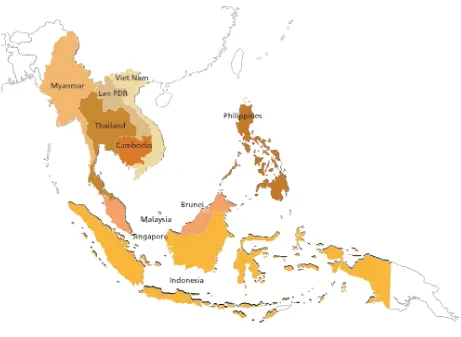
1.3 The ASEAN region
ASEAN consists of ten countries: Brunei Darussalam, Cambodia, Indonesia, Lao PDR, Malaysia, Myanmar, Philippines, Singapore, Thailand and Viet Nam. The total land area of the ASEAN region covers 4.4 million km2 (444 million ha) of land. In 2011, the collective population of the ten ASEAN countries was estimated at slightly fewer than 600 million people (ASEAN Secretariat,2012).
1.4 The ASEAN Social Forestry Network
The ASEAN Social Forestry Network (ASFN) was established in 2005 by the ASEAN Senior Officials on Forestry, who are responsible for policy coordination, decision-making and regional cooperation in the forest sector. The government-driven ASFN promotes cooperation and knowledge sharing on social forestry in the region. It links government forestry policy-makers with other stakeholders from civil society, research, academia, the private sector and elsewhere working to develop social forestry in ASEAN member countries, including its potential to address climate change mitigation and adaptation. Working under the auspices of ASEAN, the ASFN informs the Senior Officials on Forestry policy agenda and builds synergies with the ASEAN Regional Knowledge Network on Forests and Climate Change.
3
1.5 What is social forestry?
Both social forestry and community forestry refer to the involvement of local communities in the protection and/or management of public forests (Rath, 2010), with the intent to prevent degradation from overuse, promote sustainable forest management and respond to the basic social and economic needs of local people (Box 1). In theory, when the people who depend upon forest resources are jointly responsible for managing and protecting them, they tend to do so in a more sustainable manner by focusing on the long-term benefits rather than the immediate short-term gains. In contrast, where tenure rights are weak, unclear or insecure or offer limited benefits, people are provoked to extract immediate benefits, resulting in suboptimal forest management and the reduction of carbon stocks. The transfer of forest ownership, management and user rights to local people is therefore expected to lead to improvements in forest protection and conditions as well as improved livelihoods.
There is considerable evidence in the literature to suggest that when local people acquire secure tenure and forest management rights and receive adequate benefits from forest resources, this indeed leads to improved forest management, conservation of biodiversity and stronger local livelihoods (FAO, 2006; FAO, 2011; Robinson et al., 2011; Chhatre and Agrawal, 2011; Porter-Bolland et al., 2011; Persha et al., 2011; Sikor et al., 2013). Community management of forests has been shown to improve forest conditions and levels of forest biomass (Skutsch and Solis, 2010). Documented experiences in ASEAN countries demonstrate that community forestry has positive outcomes on both forest quality and local livelihoods. In Myanmar for example, community forest management has contributed to improvements in forest conditions and increased livelihood benefits for local people (Springate-Baginski et al., 2011).
The details of how forest land is transferred to local people, on what terms, with what combination of rights, benefits, responsibilities and security as well as the capacities of local communities and government officials are critical factors for ensuring sustainable forest management (Ostrom and Nagendra, 2006; FAO, 2006; Robinson et al., 2011; Helvetas and Rights and Resources Initiative, 2012; Lawry and Maclean, 2012). Well-defined and locally accepted rules governing the use of forest are also significant for achieving sustainable forest management (Patel et al., 2013). Where local people are genuinely engaged in formulating the rules on forest use – or at least consider the rules to be legitimate, they are more likely to follow them and monitor and sanction the actions of others (Ostrom and Nagendra, 2006). Forest user groups need to be able to enforce forest management regulations and protect their forests against external actors and drivers of land use change (Robinson et al., 2011). Although experience from the region suggests that in practice, this is extremely challenging (Springate-Baginski et al., 2011).
Box 1: The evolution of social forestry in Asia
Forest management in Asia has long been dominated by state actors, initially by European colonial powers and later by independent national governments. Forest communities are often regarded as “encroachers” on state land; their traditional land tenure and agriculture practices are blamed for deforestation (Poffenberger, 1999; Poffenberger et al., 2005; Poffenberger, 2006; Charnleyand Poe, 2007). Towards the end of the twentieth century, it became increasingly clear that centralized systems of forest management and intensive timber extraction were leading to environmental degradation and failing to provide for the needs of local people. Governments began to recognize the need for increased participation of local stakeholders in the rehabilitation, management and protection of forest resources. New policies, laws and programmes emerged to strengthen the role of local governments and communities in sustainable forest management and devolve greater management rights and responsibilities to local people (Sands, 2005; Poffenberger, 2006; Soriaga and Mahanty, 2008).
1.6 Definitions of social forestry and community forestry
There are many definitions and models of social forestry that emphasize different social, economic and ecological goals and levels of local participation and autonomy in forest management (Box 2). Although the term “social forestry” is sometimes used synonymously with community forestry, it is considered to have greater emphasis on social objectives, such as poverty reduction (Arnold, 1992; Poffenberger et al., 2005), and is often targeted at vulnerable or underprivileged groups. Although this publication singles out social forestry in its title, it uses the two terms somewhat interchangeably. Social forestry can also contribute to less tangible goals, such as social cohesion, social inclusion, learning and education, empowerment, emotional well-being and physical recreation. Social forestry activities can include people living within and around forests who depend on the forest for some or all of their basic needs. Social forestry takes place in both rural and urban areas and in industrialized and developing countries (Sands, 2005).
Box 2: Definitions of social forestry and community forestry
The following reflects the variance in definitions and the greater use of community forestry than social forestry.
FAO (1978): Community forestry is any situation that “intimately involves local people in a forestry activity. It embraces a spectrum of situations ranging from woodlots in areas which are short of wood and other forest products for local needs, through the growing of trees at the farm level to provide cash crops and the processing of forest products at the household, artisan or small industry level to generate income, to the activities of forest dwelling communities”.
Gilmour and Fisher (1991): Community forestry is “the control and management of forest resources by the rural people who use them, especially for domestic purposes and as an integral part of their farming systems”.
Martel and Whyte (1992): Community forestry is “a village-level forestry activity, decided on collectively and implemented on communal land, where local populations participate in the planning, establishing, managing and harvesting of forest crops and so receive a major proportion of the socio-economic and ecological benefits from the forest”.
Revington, Rainforest Information Centre (1992): “Community forestry has the following characteristics: the local community controls a clearly and legally defined area of forest; the local community is free from governmental and other outside pressure concerning the utilization of that forest; if the forestry involves commercial sale of timber or other products, then the community is free from economic exploitation of markets or other pressure from outside forces; the community has long-term security of tenure over the forest and sees its future as being tied to the forest.”
Nanang and Inoue (2000): Social forestry is “participatory forest-related activities for the purpose of sustaining and improving the economic and social welfare of people living in and around forests”.
Charnley and Poe (2007): “Community forestry refers to forest management that has ecological sustainability and local community benefits as central goals, with some degree of responsibility and authority for forest management formally vested in the community.”
Burley, Oxford Forestry Institute (2007): “Community forestry, social forestry and rural development forestry are more or less equivalent and reflect Abraham Lincoln’s view of democracy – government of the people, by the people, for the people.”
RECOFTC (2008): Community forestry “includes all aspects, initiatives, sciences, policies, institutions and processes that are intended to increase the role of local people in governing and managing forest resources. It consists of informal, customary and indigenous and formal or government-led initiatives. Community forestry covers social, economic and conservation dimensions in a range of activities, including indigenous management of sacred sites of cultural importance, small-scale forest-based enterprises, forestry out-grower schemes, company–community partnerships and decentralized and devolved forest management.”
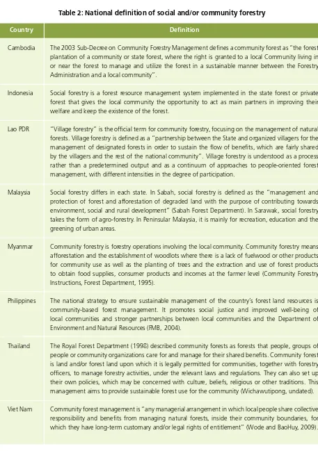
5 Each ASEAN country has developed its own definition of social or community forestry (Table 2).
Table 2: National definition of social and/or community forestry
Country
Cambodia
Indonesia
Lao PDR
Malaysia
Myanmar
Philippines
Thailand
Viet Nam
The 2003 Sub-Decree on Community Forestry Management defines a community forest as “the forest plantation of a community or state forest, where the right is granted to a local Community living in or near the forest to manage and utilize the forest in a sustainable manner between the Forestry Administration and a local community”.
Social forestry is a forest resource management system implemented in the state forest or private forest that gives the local community the opportunity to act as main partners in improving their welfare and keep the existence of the forest.
“Village forestry” is the official term for community forestry, focusing on the management of natural forests. Village forestry is defined as a “partnership between the State and organized villagers for the management of designated forests in order to sustain the flow of benefits, which are fairly shared by the villagers and the rest of the national community”. Village forestry is understood as a process rather than a predetermined output and as a continuum of approaches to people-oriented forest management, with different intensities in the degree of participation.
Social forestry differs in each state. In Sabah, social forestry is defined as the “management and protection of forest and afforestation of degraded land with the purpose of contributing towards environment, social and rural development” (Sabah Forest Department). In Sarawak, social forestry takes the form of agro-forestry. In Peninsular Malaysia, it is mainly for recreation, education and the greening of urban areas.
Community forestry is forestry operations involving the local community. Community forestry means afforestation and the establishment of woodlots where there is a lack of fuelwood or other products for community use as well as the planting of trees and the extraction and use of forest products to obtain food supplies, consumer products and incomes at the farmer level (Community Forestry Instructions, Forest Department, 1995).
The national strategy to ensure sustainable management of the country’s forest land resources is community-based forest management. It promotes social justice and improved well-being of local communities and stronger partnerships between local communities and the Department of Environment and Natural Resources (FMB, 2004).
The Royal Forest Department (1998) described community forests as forests that people, groups of people or community organizations care for and manage for their shared benefits. Community forest is land and/or forest land upon which it is legally permitted for communities, together with forestry officers, to manage forestry activities, under the relevant laws and regulations. They can also set up their own policies, which may be concerned with culture, beliefs, religious or other traditions. This management aims to provide sustainable forest use for the community (Wichawutipong, undated).
Community forest management is “any managerial arrangement in which local people share collective responsibility and benefits from managing natural forests, inside their community boundaries, for which they have long-term customary and/or legal rights of entitlement” (Wode and BaoHuy, 2009).
1.7 Climate change
Southeast Asia is highly vulnerable to the impacts of climate change; in particular, storms, floods, water scarcity and sea-level rise. The Fourth Assessment Report of the Intergovernmental Panel on Climate Change (IPCC) in 2007 pointed out the changes taking place in Southeast Asia’s climate, including rising temperatures, increases in the number of hot days and nights and decreases in the number of cold days and nights (Barker, 2007). Other studies indicate that precipitation is reducing and sea levels are rising by 1–3 mm every year (ADB, 2009).
These observations are supported by national data (presented in chapter 3) showing temperature increases over the past 50 years and notable changes in the numbers of hot and cold days and nights. Patterns of precipitation and the timing of the seasons are becoming more unpredictable, and there is a marked increase in the frequency and severity of floods, droughts and storms. The Philippines and Viet Nam are experiencing increasingly frequent and severe storms and typhoons. Flooding is a major risk in Cambodia, Lao PDR, Thailand and Viet Nam, while Indonesia, Myanmar and Viet Nam are highly vulnerable to the impacts of sea-level rise (World Bank, 2009). In a global study of 50 cities, five of the seven cities identified as at “extreme risk” to climate change are located in the ASEAN region7 (Maplecroft, 2013).
Climate change presents a major risk to economic development across the region. It is expected to reduce the availability of clean water, negatively impact agricultural yields, biodiversity and the availability of forest products and cause greater incidence of diseases, such as malaria and dengue fever. These impacts will endanger the livelihoods of millions of people, particularly rural populations who depend directly on forests, agriculture and other natural resources. Climate change is projected to cause economic losses of $230 billion8 each year by 2100, equivalent to 6.7 percent of the region’s gross domestic product (GDP). This is more than twice the projected global average loss of 2.6 percent, indicating that Southeast Asia will be more seriously impacted by climate change than other regions (ADB, 2011).
1.8 Forests and climate change mitigation and adaptation
Through the carbon cycle, carbon dioxide (CO2) is exchanged between the atmosphere, the oceans and the terrestrial biosphere. Through the process of photosynthesis, trees and plants (and forest soils) withdraw CO2 from the atmosphere and store it in their trunks, branches, leaves and roots. CO2 is returned to the atmosphere through the respiration of vegetation and when trees, plants and soils decompose and burn. Reducing deforestation and forest degradation and increasing forest cover can help to reduce anthropogenic CO2 emissions.
Estimates of CO2 emissions from land use change and forestry vary widely, depending on the methodology used. In 2007, the Intergovernmental Panel on Climate Change estimated that emissions from deforestation in the 1990s made up 17.4 percent of total anthropogenic emissions (Barker et al., 2007) (Box 3). Recent estimates suggest that deforestation and forest degradation produce between 6 and 17 percent of total anthropogenic CO2 emissions (van der Werf, 2009; Harris et al., 2012). In Southeast Asia, land use change and forestry produce an estimated 75 percent of the region’s total greenhouse gas emissions, compared with 15 percent from the energy sector and 8 percent from agriculture (ADB, 2009)9, which highlights the considerable potential for forest-based mitigation in the ASEAN region.
Forests are important in terms of climate change adaptation. They provide a range of ecosystem services, such as the provision of forest products, soil and nutrient cycling, the regulating of water quality and flow and coastal protection in the case of mangrove forests. These services underpin the health and well-being of forest communities and human society in general and increase people’s resilience and ability to cope with the negative impacts of climate change. Forests serve as a natural safety net, providing essential products and services, such as food, water, shelter and building materials, that help people to cope and recover from weather-related disasters, such as floods, droughts or storms.
7 Of the seven cities cited as facing extreme risks from climate change, Dhaka (Bangladesh) was found to be at greatest risk, followed by Manila (Philippines), Bangkok (Thailand), Yangon (Myanmar), Jakarta (Indonesia), Ho Chi Minh City (Viet Nam) and Kolkata (India).
8 All $ figures are US$.
7
Box 3: Estimations of CO2 emissions from deforestation, forest degradation and land use change
Deforestation and forest degradation generate between 12 and 18 percent of anthropocentric emissions. In 2007, the Intergovernmental Panel on Climate Change estimated that 17.4 percent of manmade emissions in the 1990s were caused by deforestation (Barker, 2007). More recent studies suggest that emissions from deforestation and forest degradation make a smaller contribution to total global emissions, although this is partially due to the increase in the emissions produced by burning fossil fuels. CO2 emissions from deforestation and forest degradation (excluding peatland emissions) were estimated at 1.2 petagrams of carbon per year in 2008, approximately 12 percent of the total CO2 emissions (van der Werf et al., 2009). Winrock International researchers estimated gross CO2 emissions from tropical deforestation from 2000 to 2005 at 0.81 petagrams of carbon per year and between 7 and 14 percent of total anthropogenic CO2 emissions. This figure does not include emissions from forest degradation and peat soil drainage and fire, which is estimated to produce an additional 0.6 petagrams of carbon per year (Harris et al., 2012). In a study by the Woods Hole Research Centre, the researchers estimated that net carbon emissions from tropical deforestation and land use at 1 petagram of carbon per year between 2000 and 2010 (Baccini et al., 2012).
1.9 Social forestry and climate change mitigation and adaptation
In addition to promoting sustainable forest management and providing social and economic benefits for local communities, social forestry has considerable potential to contribute to both climate change mitigation activities and community-level adaptation strategies. As noted, secure tenure and access to forest resources generally lead to improved forest management, reduced deforestation and forest degradation and increased forest carbon stocks. Social forestry programmes can support the implementation of climate change mitigation efforts under the Reducing Emissions from Deforestation and Forest Degradation Plus (REDD+) framework by involving local communities in carbon measuring and monitoring activities (Box 4).
Box 4: Reducing Emissions from Deforestation and Forest Degradation (REDD) and REDD+
Reducing Emissions from Deforestation and Forest Degradation (REDD) is a framework for providing compensation, in the form of financial payments, for the long-term benefits associated with forest protection, specifically reduced carbon emissions. It is a scheme to provide payment for ecosystem services (PES). The basic principle is that developing countries would be financially compensated by industrialized countries for reducing deforestation and forest degradation through either voluntary or compulsory funding mechanisms that incentivize forest protection. The + in REDD+ represents the expanded principle of sustainable forest management, forest conservation and the enhancement of forest carbon stocks. In addition to climate change mitigation, REDD+ has the potential to contribute to other ecological and developmental goals through so-called “co-benefits”, such as biodiversity conservation, maintaining ecosystem services, recognition of the rights of forest peoples and building up their capacity at the local level to manage their forest.
Forest ecosystems can reduce the exposure of local people to climate risks (Box 5). For example, mangrove forests can protect coastal communities from damage caused by storms and cyclones. Community-managed mangrove forests in Myanmar’s Ayeyarwady Delta are credited with reducing the impact of Cyclone Nargis in 2008 and saving many lives. Social forestry activities can reduce the vulnerability of forest communities to the impacts of climate change and its associated risks (Locatelli et al., 2008; FAO, 2012; RECOFTC, 2012). For example, community-maintained fire breaks and the clearing of leaf litter can reduce the spread of forest fires, and reforestation on sloping lands can help to reduce the risks of flash flooding and landslides.
The social dimensions of climate change and vulnerability are becoming more widely understood. Social factors, such as social structures, norms, governance systems, institutions and power relations, can create, increase or reduce vulnerability to climate change. The most vulnerable, poor or socially excluded groups in society have higher levels of vulnerability to climate change. For example, men and women are affected differently by environmental or climate stresses and disasters due to gender roles and responsibilities and traditional resource use patterns. By engaging groups who are frequently marginalized – such as indigenous people, forest-dependent communities, the rural poor and women – in local participatory processes and building individual skills and collective capacities in planning, decision-making and problem solving, social forestry can contribute to social inclusion and empowerment and help to address the social dimensions of vulnerability.
Box 5: Traditional land use systems sequester carbon and enhance adaptive capacity
Ban Mae Nam Kham is a Karen village situated near a national reserve forest in Thailand’s Chiang Mai Province. Land is communally held, with individual plots allocated to each family on a yearly basis. The community uses a traditional system of rotational farming within a seven-year cycle, meaning that fallow lands are reused periodically and no additional forest areas are cleared. For every plot of land that is cleared in a particular year in this system, six fallow plots are sequestering carbon and thus producing a net carbon sink.
The rotational farming system protects critical ecosystem services by maintaining soil quality and protecting watershed functions. The community produces a range of crops throughout the year, including rice, fruits and vegetables. They also collect non-timber forest products, raise buffaloes and weave cloth to generate additional income. The diverse range of crops and income-generating options makes the community resilient to the negative impacts of climate change.
The village is a member of a local natural resource management network covering three districts in the Mae Sai River Basin. As part of this network, villagers take part in forest fire prevention activities that involve maintaining a firebreak that is 126 km long and 5–10 m wide and clearing leaf litter from the forest floor. The network has been successful in reducing the incidence of forest fires, particularly when compared with neighbouring districts that have experienced increased forest fires in the past five years.
11
2. Forests and social forestry in
the ASEAN region
2.1 Differing definitions of forest, forest land and forest cover
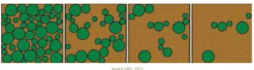
International organizations and various relevant conventions rely on different definitions and classifications of “forest” and “forest land”. For example, FAO defines forest as a land area of more than 0.5 ha, with trees higher than 5 m and a canopy cover of more than 10 percent. The United Nations Framework Convention on Climate Change (UNFCCC) defines forest as a land area that is 0.01–1 ha in size, with trees higher than 2–5 m and a crown cover of 10–30 percent. The United Nations Environment Programme (2001) distinguishes between “forest cover” (as a canopy density greater than 10 percent) and “closed forest” (as a canopy density of 40 percent). Greater harmonization of the definitions used would be beneficial in reducing errors, reducing the burden and costs of reporting and minimizing confusion in communicating with stakeholders, the media and the public (FAO, 2002).
There are also differences at the national level. For example, Lao PDR uses a minimum canopy density of 20 percent to define “forest”, while other ASEAN countries use a minimum of 10 percent canopy cover. The use of the 10 percent threshold for areas defined as forests means that significant changes in forest cover above this threshold go unrecorded – considerable forest degradation may occur without being reflected in official statistics (Figure 2), leading to “hidden deforestation” (FAO, 2011; Sasaki and Putz, 2009).
Figure 2: Representations of 70 percent, 40 percent, 20 percent and 10 percent canopy cover
10 In Indonesia, there is reportedly around 15 million ha of forest outside the designated forest estate. See the CIFOR Forests news blog at http://blog.cifor. org/3753/land-tenure-reform-starting-to-gain-momentum-in-indonesia/#.UigikmmkdMs [5 Sept. 2013].
Additionally, the term “forest land” is used as a legal or administrative term rather than the presence of forest of trees. For example, in Indonesia, a “forest area” refers to an area of land that has been designated as permanent forest land by the Government, regardless of whether trees are present. Bare or degraded forest land that has been set aside for regeneration and fallow land used in shifting cultivation also may be classed as forest land even though the land does not have permanent tree cover. And there may be considerable areas of forest that exist outside the area officially designated as forest land.10
Statistics on total forest cover frequently include both natural and planted forests and can mask the conversion of natural forests to plantations. A detailed assessment of changes in the types of forest cover is needed to identify and understand trends.
Many experts do not consider plantations to be “forest” because they are monocultures, often consisting of non-native species and not performing the full functions of a healthy natural forest ecosystem (FAO, 2002). As well, natural forests contain an estimated five to ten times more carbon stocks than tree plantations (VNFOREST, 2013). The ability to distinguish between natural forests and plantations is of particular importance in calculating forest carbon stocks and the emissions associated with the conversion of natural forests to planted forests.
National definitions of forest and forest cover types also vary (Table 3). For example, bamboo forests and unstocked forests are included in forest cover assessments in the Philippines but not in Lao PDR. Forest definitions, classifications, survey methods and technologies used to calculate forest cover also change and develop over time, so historical forest data may
not be comparable. And the reported increases or decreases in forest cover may be a result of the different definitions, methodologies and technologies used rather than a reflection of actual changes on the ground.
Table 3: National forest definitions
The use of different definitions by each ASEAN country makes uniform reporting on forests and forest cover in the region extremely challenging. Additionally, many forestry issues are cross-border in nature and require collaboration between countries to tackle them effectively. The different definitions and understandings of terms and the different methodologies used makes reporting and coordination more difficult.
Country
Cambodia
Indonesia
Lao PDR
Malaysia
Myanmar
Philippines
Thailand
Viet Nam
The 2006 forest assessment used the FAO definition of forest: 10 percent or more canopy coverage, minimum area of 0.5 ha and minimum 5 m tree height (RGC, 2010). The 2010 forest classification included evergreen forest, semi-evergreen forest, deciduous forest, other forest, wood shrub dry, wood shrub evergreen, bamboo, mangrove forest and rubber plantation (mangrove forest and rubber plantations were added in 2010).
Forest area is any particular area designated by the Government to be permanent forest. Forest cover includes primary dryland forest, secondary dryland forest, primary swamp forest, secondary swamp forest, primary mangrove forest, secondary mangrove forest and plantation forest (MOF, 2012).
“Current forest” is defined as natural forest or tree plantation with a canopy density greater than 20 percent, a minimum area of 0.5 ha and average tree height above 5 m. Bamboo forest, fallow forest and unstocked forest with less than 20 percent canopy density are not included as current forest (GOL, 2005).
The Government uses the FAO definition of land area greater than 0.5 ha, with trees higher than 5 m and a minimum 10 percent canopy cover or trees able to reach these thresholds in situ. Data on forest cover include permanent reserved forest, state land forest, national parks, wildlife and bird sanctuaries and rubber plantations (FAO, 2010b).
Forest area is land with tree crown cover (or equivalent stocking level) of more than 10 percent and an area of more than 0.5 ha. The trees should reach a minimum height of 5 m at maturity in situ (MOF, 2005).
The Department of Environment and Natural Resources uses the following definition of forest: land areas greater than 0.5 ha, with a tree crown of more than 10 percent and trees capable of reaching a height of 5 m at maturity. Young natural stands and forestry plantations in which trees have yet to reach 10 percent crown and 5 m in height are included as forests as well as temporarily unstocked areas that are expected to revert to forest. The definition includes rubber plantations, bamboo, palm and fern formations, forest nurseries, seed orchards, forest roads and firebreaks. Coconut and oil palm plantations are not included (DENR, 2005).
The existing forest area is defined as land spanning more than 0.6 ha that can be classified using Landsat data, at 30m resolution. It does not include land predominantly under agricultural or urban land use (FAO, 2010c). Forest cover assessments include natural forests, secondary and planted forests and the following forest types: tropical evergreen, mixed deciduous, dry dipterocarp, swamp forest, inundated forest, beach forest, pine forest, bamboo forest and mangrove forest.
The national definition of forest is an area of at least 0.5 ha, with trees higher than 3 m and a canopy cover of 0.3 ha or growing stock over 30 m3 per ha (FAO, 2010d). Assessments of forest cover include natural forests of timber, bamboo, mangrove, mixed and rocky mountain forest and plantations of timber, bamboo, mangrove and other specialty species (VNFOREST, 2013).
13
11 The national forest reserve in Cambodia has not yet been officially demarcated and is therefore not included in this figure. 12 With the exception of Singapore, for which the 2010 FAO forest resources assessment data were used.
2.2 Status of forests
14 Table 4: Forest land, forest cover and forest cover change in ASEAN countries
Designated Forest Area Actual Forest Cover Average Annual Rates of Forest Cover Change ha % land area ha % land area ha per year period % forest cover
1 Brunei Forest Department. Current gazetted forest area is 235,520 ha. Plus 86,675 ha of forest is proposed for gazettement. http://www.forestry.gov.bn/frst_forest.htm Accessed 18 April 2013. Cover change data from FAO 2010.
2 Data from Cambodia Forest Cover 2010. Change rate calculated by the author based on FA 2006 and FA 2010.
3 National Level Forestry Plan 2011-2030, Ministerial Regulation No. P.49/Menhut-II/2011, DG of Forestry Planning; and Directorate of Social Forestry Development, MoF, presented at 2nd ASFN Learing Group Workshop. February 2013. Change
rate for 2005/6 to 2009/10 from MoF Forest Statistics 2012.
4 Government Sector Lao PDR 2010, presented at 2nd ASFN Learing Group Workshop, February 2013. Data presented by government presents forest cover change as a percentage of total land (-0.15%). In this study it is presented as a % of
forest cover to enable comparison with other countries.
5 Forest cover data presented at 2nd ASFN Learning Group Workshop. February 2013. Forest cover change data from FAO 2010.
6 Myanmar Forest Department, presented at 2nd ASFN Learning Group Workshop. February 2013
7 Forest cover data is based on data from the 2003 inventory, presented at ASFN Learning Group Workshop in February 2013. Cover change rate was provided by DENR in July 2013. Philippines Land Cover Mapping for 2010 is taking place in
2013 and should be available in 2014.
8 FAO 2010a
9 Data provided by the Thai Royal Forest Department in May 2013.
15 Based on the data provided by each forest department (Table 5), total forest cover is more than 13 million ha – smaller than the figure reported in the 2010 baseline assessment (RECOFTC, ASFN and SDC, 2010) and the 2010 forest resources assessment (FAO, 2010a). A significant part of this change is due to the different parameters used to measure forest cover in the FAO forest resources assessment and by each state forest department, particularly in the case of Lao PDR.13
Table 5: Comparison of forest cover data from the 2010 FAO forest resources assessment and national forest departments, 2013
13 The 2010 baseline assessment used the 2010 FAO forest resources assessment data, based on 10 percent canopy cover resulting in 15.8 million ha of forest cover. The Lao PDR Department of Forestry used a 20 percent canopy cover threshold to produce the current figure of 9.6 million ha.
Brunei
Country Forest resource assessment 2010 Forest department 2013 Variance
ha % land area ha % land area ha
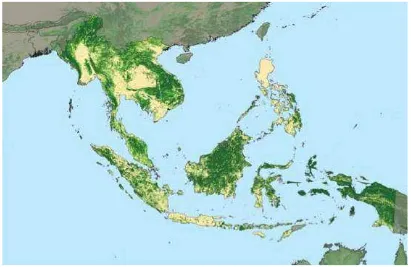
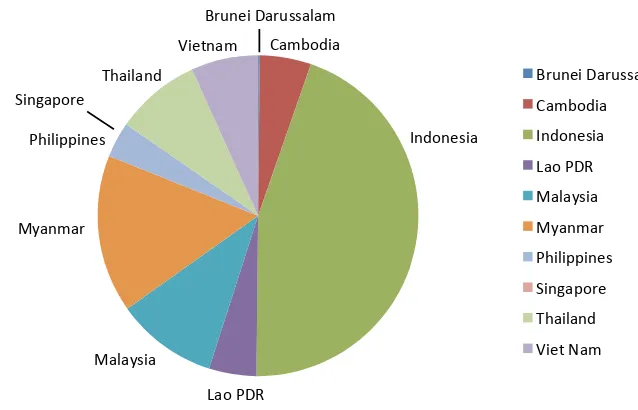
Among the ASEAN countries, Indonesia has the largest amount of forest cover, at almost 90 million ha, covering 49 percent of its land area (MOF, 2011).14 Brunei Darussalam, Cambodia and Malaysia have more than 50 percent of their land covered with forest.15 With the exception of Singapore, the Philippines has the smallest proportion of forest cover, at only 24 percent of the total land area, making it one of the most heavily deforested countries in the tropics (DENR, 2002). Figure 4 reflects the distribution of forest cover in the eight ASEAN countries covered in this study.
Figure 4: Distribution of forest cover in the ASEAN region, 2013
Forests in the ASEAN region are under pressure from a complex range of direct and indirect anthropogenic pressures. Based on the 2010 FAO data, forest cover in Southeast Asia is estimated to have declined by an average of 1.2 million ha per year between 2005 and 2010 (FAO, 2010a). Figure 5 shows the decline in forest cover in the ASEAN region since 1990 (based on the 2010 forest resources assessment data) and the current area of forest cover.
Figure 5: Forest cover in ASEAN countries 1990–2010 (in thousands of ha)
14 National Level Forestry Plan 2011–2030, Ministerial Regulation No. P. 49/Menhut-II/2011, Directorate-General of Forestry Planning, Ministry of Forestry, presented at the second ASFCC Learning Group Workshop, February 2013.
15 Cambodia and Malaysia include some tree plantations as forest cover.
Forest Resources Assessment (FRA) data
246,294
222,191 218,698
213,322
150,000 175,000 200,000 225,000 250,000 275,000 300,000
1990 2000 2005 2010 2013
Brunei Darussalam Cambodia
Indonesia
Lao PDR Malaysia
Myanmar Philippines Singapore
Thailand
Vietnam
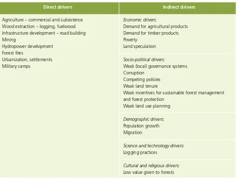
17 Many factors contribute to deforestation, including the direct causes of forest loss as well as underlying economic, socio-political, demographic and cultural factors (Table 6). Direct drivers of deforestation include clearance for agricultural production, wood extraction, forest fires, infrastructure development, increasing urbanization and human settlements. Indirect drivers include consumer demand for timber and agricultural products, weak local governance and corruption, weak land tenure, population growth, migration and poverty (Zurek et al., 2013).
Table 6: Drivers of deforestation in ASEAN countries
Forest cover in most ASEAN countries is in decline. Indonesia has the largest annual reduction in forest area, with 832,127 ha (0.89 percent) lost each year between 2006 and 2009 (MOF, 2012). Myanmar has the highest rate of deforestation, with forest cover falling by 0.91 percent (310,000 ha) per year. The deforestation rate increased from 0.87 percent in 2006 to 0.91 percent in 2010 (MOECAF, 2013). Lao PDR currently has the lowest deforestation rate, at 34,650 ha per year, with the exception of Singapore, where the small area of remaining forest is protected. Other countries report an increase in forest cover. In Viet Nam, forest cover increased by 1.7 million ha between 2002 and 2011 due to large-scale reforestation programmes and currently stands at 41 percent of the total land area (VNFOREST, 2013). In the Philippines, inventory data indicates that forest cover increased from 5.4 million ha in 1988 to 7.2 million ha in 2003.16
2.3 Forest area managed by local people in the ASEAN region
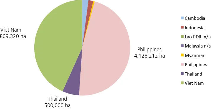
In 2013, 8.8 million ha of forest land were managed by local people through official community forestry agreements or land titles.17 This accounted for 3.5 percent of the region’s total forest land. Since 2010, more than 2.2 million ha of forest land have been officially placed under the management of local people (Table 7).
16 The forest inventories of 1988 and 2003 used different methodologies to estimate forest cover (FAO, 2005), which may account for some of the reported increase.
17 Data is based on formal community forestry agreements issued to communities or households. It does not include agreements that are currently being processed, unrecognized claims to forest lands, community forestry activities taking place on land managed by the State or commercial license holders or forest lands that local people are entitled to access and use that are not covered by official community forest agreements or titles.
Economic drivers:
Demand for agricultural products Demand for timber products Poverty
Land speculation
Socio-political drivers:
Weak (local) governance systems Corruption
Competing policies Weak land tenure
Weak incentives for sustainable forest management and forest protection
Weak land use planning
Demographic drivers:
Population growth Migration
Science and technology drivers:
Logging practices
Cultural and religious drivers:
Low value given to forests Agriculture – commercial and subsistence
Wood extraction – logging, fuelwood Infrastructure development – road building Mining
Hydropower development Forest fires
Urbanization, settlements Military camps
Direct drivers Indirect drivers
Cambodia
The vast majority (90 percent) of this land is in the Philippines and Viet Nam, where around 25 percent of forest land is managed by local people (Figure 6). In Cambodia, Indonesia, Myanmar and Thailand, the area managed by local people is between 0.1 and 2 percent of total forest land. Official data on land area managed under approved community forestry agreements in Lao PDR and Malaysia were not available at the time of writing but is likely to be quite small areas. According to the Lao PDR Forest Sector Strategy to 2020, 8.2 million ha of forest land was allocated to villages and households through the Land and Forest Allocation Programme (MAF, 2005). However, village forests only exist as a land use category; few community forest lands are covered by formal land use titles (RECOFTC, 2013). In Malaysia, social forestry takes the form of agro-forestry and village development projects target state forestland.
Figure 6: Land area managed by local people under official community forestry agreements, 2013
18 Community held management rights over public forests in 2005 (FAO, 2010). 19 Land under HKm (community-based forest) and hutan desa (village forest).
20 The Forest Sector Strategy to 2020 reports that 8.2 million ha of forest land was allocated to villages and households through the Land and Forest Allocation Programme (MAF, 2005). However, village forests only exist as a land use category; few community forest lands have received formal land use titles to date (RECOFTC, 2013).
21 Data on social forestry in Malaysia is limited. A 2006 report estimates that 40,654 ha (1.5 percent of forest management units of land) had been set aside for social forestry projects in Sabah, of which 7,000 ha was managed by the Sabah Forest Department and 33,654 ha by sustainable forest management license holders (Toh and Grace, 2006). There were no recent data on active social forestry projects in Sabah state or for Malaysia as a whole.
22 Community-held management rights over public forests in 2005 (FAO, 2010).
Table 7: Comparison of forest area covered by community forestry agreements in 2010 and 2013
Cambodia
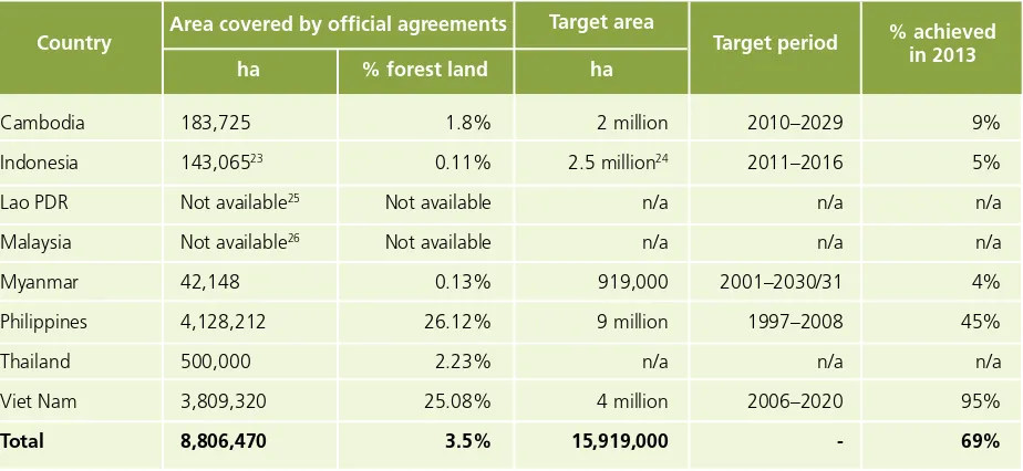
Cambodia, Indonesia, Myanmar, Philippines and Viet Nam have set national targets on the area of forest land to be transferred to local communities for community forestry. Collectively, these targets would place 15.9 million ha, or 6 percent of total forest land, under the management of local people by 2030 (Table 8). In 2006, Viet Nam set a target of transferring 4 million ha of land to local people. By 2013, 95 percent of this target area had been allocated. In other countries, the
19 transfer of forest land to local people is proceeding more slowly. In 1997, the Philippines set a target of allocating 9 million ha of land to local communities by 2008. By 2013, only 45 percent of this target area had been allocated (DENR, 2013). Community forestry programmes in Cambodia, Indonesia and Myanmar will need to be scaled up if national targets are to be met.
Table 8: Forest area managed by local people with official community forestry agreements, 2013
2.4 Social forestry models
The ASFN considers social forestry to be an integral part of sustainable forest management because it aims to improve the standard of living and well-being of local people.27 The ASFN recognizes that social forestry is a cost-effective way to: support sustainable local livelihoods through income generation;
• balance economic use and ecological conservation of forests;
• build the capacity of forest communities to practise land stewardship and reduce forest degradation and destruction; • combat illegal logging;
• share the benefits from forests among local communities;
• build upon the potential of local communities to manage forests sustainably; and • promote democratic and transparent governance practice.
The participation of local people in forest management has become a feature of national forest policy in most ASEAN countries over the past 20 years. Social forestry models share similar objectives of encouraging sustainable forest management, improving forest condition, governing local use of forest resources and improving the social and economic conditions of forest-dependent people. Despite shared common objectives, social forestry models in the ASEAN region have notable differences. Some models prioritize community management, while other models are based on local partnerships between communities and local councils or business license holders. Different social forestry models also exist depending on the type of forest (such as production forest, protection or conservation forest) and purpose (commercial activities, reforestation or conservation).
23 Land under HKm (community-based forest) and hutan desa (village forest).
24 Statement by Indonesia’s Director of Social Forestry Development at the Asia REDD+ Regional Working Group, January 2013 (CFI, 2013).
25 The Forest Sector Strategy to 2020 reports that 8.2 million ha of forest land was allocated to villages and households through the Land and Forest Allocation Programme (MAF, 2005). However, village forests only exist as a land use category; few community forest lands have received formal land use titles to date (RECOFTC, 2013).
26 Data on social forestry in Malaysia is limited. A 2006 report estimates that 40,654 ha (1.5 percent of forest management units of land) had been set aside for social forestry projects in Sabah, of which 7,000 ha was managed by the Sabah Forest Department and 33,654 ha by sustainable forest management license holders (Toh and Grace, 2006). There were no recent data on active social forestry projects in Sabah state or for Malaysia as a whole.
27 Consolidation of the working group discussion in the ASEAN Workshop on Social Forestry, in Madiun, East Java, Indonesia, 28–30 March 2005 (available at www.dephut.go.id/informasi/Umum/KLN/Consolidation.htm).
Country Area covered by official agreements
Target area % achieved
in 2013
ha % forest land ha