Methods to aggregate turbulent fluxes over heterogeneous
surfaces: application to SALSA data set in Mexico
A. Chehbouni
a,b,∗, C. Watts
a, Y.H. Kerr
b, G. Dedieu
b, J-C. Rodriguez
a,
F. Santiago
a, P. Cayrol
b, G. Boulet
a, D.C. Goodrich
caIRD/IMADES, Reyes&Agascalientes Esq., Col. San Benito, CP. 83190, Hermosillo, Sonora, Mexico bCESBIO (CNES-CNRS-UPS-IRD), 18 avenue Edouard Belin, 31401 Toulouse Cedex, France
cUSDA-ARS, Tucson, AZ, USA
Abstract
The issue of using remotely sensed surface temperature to estimate the area-average sensible heat flux over surfaces made up of different vegetated patches has been investigated. The performance of three aggregation procedures, ranging from physically based through semi-empirical, to entirely empirical has been assessed by comparing measured and simulated area-average sensible heat flux. The results show that the physically based scheme perform very well. The performance of the entirely empirical scheme was reasonable but that of the semi-empirical scheme, which actually takes full advantage of remotely sensed data, was very poor. This result suggests that unlike the case of surface fluxes, it is not appropriate to use relationships between model and observational variables (here radiative and aerodynamic surface temperature) that were developed and calibrated at a local/patch scale, for an application at a larger/grid scale just by scaling the parameters. Therefore, future research should be directed towards building robust relationships between model and observational variables directly at the large-scale. © 2000 Elsevier Science B.V. All rights reserved.
Keywords:Aerodynamic and radiative surface temperatures; Effective parameters; Aggregation rules; Blending height; Surface heterogeneity
1. Introduction
It is well known that land characteristics vary across a wide range of spatial scales, from a few meters to hundreds of kilometers. Yet most large-scale atmo-spheric models assume homogeneity within a grid square and use the dominant vegetation type to spec-ify the surface flux-controlling parameters. The issue of improving the representation of sub-grid scale het-erogeneity in regional and global climate models has been an active research topic during the past decade. Consequently, substantial progress has been made
∗Corresponding author. Fax:+33-5-61-55-85-1.
E-mail address:[email protected] (A. Chehbouni).
in the development of aggregation schemes to esti-mate area-average surface fluxes over heterogeneous surfaces (Koster and Suarez, 1992; Braden, 1994).
Two main approaches have been used in develop-ing such schemes: a stochastic-dynamic approach and a deterministic one. The stochastic approach consists of describing the heterogeneity of a surface parameter using a probability density function PDF (Avissar, 1992; Li and Avissar, 1994; Boulet et al., 1990). The unsolved issue here is to establish relationships between the PDFs of different surface parameters knowing their link at the local scale (through the wa-ter or energy balance for example). The dewa-terministic approach, also called ‘the conceptual’ approach, con-sists of formulating grid-scale surface fluxes using the
134 A. Chehbouni et al. / Agricultural and Forest Meteorology 105 (2000) 133–144
same equations that govern the patch-scale behavior but whose arguments are the aggregate expressions of those at the patch-scale.
The strategy for linking local and aggregate or effec-tive surface parameters can also be divided into two categories. The first one is essentially empirical and consists of postulating hypothetical rules such as con-sidering that aggregate parameters can be derived as area-weighted averages of the local ones (Shuttle-worth, 1991; Blyth et al., 1993; Noilhan and Lacar-rere, 1995; Arain et al., 1996; Sellers et al., 1997; Noilhan et al., 1997). The second is theoretical, where the relationships between local and effective surface parameters are derived analytically, through the matching of the model equations between scales (Raupach, 1991, 1993; Lhomme, 1992; Lhomme et al., 1994; McNaughton, 1994; Raupach and Finni-gan, 1995; Chehbouni et al., 1995).
Research is currently under way to use remotely sensed data to improve the representation of surface heterogeneity in large-scale models (Sellers et al., 1997; Bastiaansen et al., 1998; Avissar, 1998). In this regard, Pelgrum and Bastiaanssen (1996) used Land-sat Thematic Mapper (TM) images in conjunction with an energy balance model to derive area-average surface fluxes during the European Field Experi-ment in a Desertification-Threatened Area (EFEDA). Moran et al. (1997) address the issue of sensible heat flux aggregation using several sets of spectral im-ages with different spatial resolution taken during the MONSOON’90 experiment. They conclude that there was substantial error in aggregation of sensible heat flux for sites with differences in surface roughness. Arain et al. (1996) have shown that the incorporation of remotely sensed land-cover classes improves the performance of global climate model simulations.
To take full advantage of the increasingly avail-able remotely sensed data, one needs to establish, at different scales, relationships that link remote sens-ing observations to the variables needed to formulate surface fluxes (Njoku et al., 1996). Remotely sensed surface temperature is believed to be very useful for estimating surface fluxes since it results from the ther-mal equilibrium of the land-surface. Yet it represents a perfect example of the difficulties encountered in using remotely sensed data to infer surface fluxes over heterogeneous surfaces. From a theoretical viewpoint, sensible heat flux should be expressed in terms of the
aerodynamic surface temperature since it is the aero-dynamic surface temperature, which determines the loss of sensible heat flux from a surface. Aerodynamic surface temperature can be defined as the extrapola-tion of air temperature profile down to an effective height within the canopy located at the same height as the effective sink of momentum, at which the vegetation components of sensible and latent heat flux arise. Since aerodynamic surface temperature cannot be directly measured, it is often replaced by radiative surface temperature in the formulation of sensible heat flux. This usually requires, especially over sparsely vegetated surfaces, that a supplementary resistance, called excess resistance, be added to the aerodynamic resistance so that the simulated fluxes fit the measured ones. Adding such a resistance is fun-damentally equivalent to establishing a relationship between radiative and aerodynamic surface tempera-tures. This issue has been heavily investigated during the past two decades (Kustas et al., 1989; Moran et al., 1994; Stewart et al., 1994; Sun and Mahrt, 1995; Chehbouni et al., 1996, 1997; Lhomme et al., 1997; Troufleau et al., 1997; Cahill and Parlange, 1997). However, most of these studies have been confined to a patch-scale. The situation where different patches exist in the same grid has received less attention.
The objective of this study is to examine the perfor-mance of three different aggregation schemes or proce-dures to estimate area-average sensible heat flux over heterogeneous surfaces using radiative surface tem-perature. The surface is made up of two distinct and adjacent patches: sparse grass of about 0.8 km×1 km and sparse mesquite of about 1 km ×1 km. Mea-surements, which were taken during the Semi-Arid Land-Surface-Atmosphere (SALSA) research pro-gram, are used to compare the performance of the three different aggregation schemes. Finally, the pos-sibilities and limitations for using aggregation rules in conjunction with remotely sensed data in free running predictive mode (stand-alone mode) are discussed.
2. Site and data description
for addressing a large number of scientific challenges in arid and semi-arid areas. The basin represents a transition area between the Sonoran and Chihuahuan deserts. It is an international basin spanning the Mexico–United States border with significantly dif-ferent cross-border legal and land use practices, as well as significant topographic and vegetation variation. Major vegetation types include desert grasslands, shrub-steppe, mesquite, oak Savannah, Pinyon-juniper, and Ponderosa pine.
The specific objective in the Mexican part of the basin was to investigate the effect of land degrada-tion (grass-mesquite transidegrada-tion) on the partidegrada-tioning of available energy into sensible and latent heat flux. To achieve this objective, two contrasting sites rep-resenting different situations with respect to surface degradation have been instrumented. The first site is a native and well managed grassland, which represents the pre-degradation conditions in the basin; the sec-ond is a mesquite site representing the ultimate stage of the degradation process.
Toward the end of the growing season, a degraded grassland site adjacent to the mesquite site was instru-mented for this particular study. This provides a grid made up of two adjacent sites/patches of about 1 km2 each. The vegetation cover was sparse, about 35% in the grass (Bouteloua) patch and about 30% in the mesquite (Prosopis velutina) patch. The aerodynamic characteristics of the two vegetation types were very different; the average grass height was about 0. 25 m while the average mesquite height was about 4.26 m. Values of leaf-area-index (LAI) for the grass and for the mesquite were estimated to be 0.3 and 0.85, respectively.
A meteorological tower of 12 m height was installed in the middle of the mesquite site and one of 3 m in that of the degraded grassland site. These towers were equipped with a set of standard meteorological instruments to measure the air temperature, relative humidity, incoming solar radiation, wind speed, wind direction, and precipitation. These standard meteoro-logical measurements were sampled every 10 s and an average was recorded every 30 min. Over the mesquite site, sensible and latent heat fluxes were measured using a 3D sonic anemometer, a fast response ther-mocouple and a fast response hygrometer (Campbell Scientific Inc., USA). Over the grass site sensible heat flux was measured using a 3D sonic anemometer
(Applied Technology, USA). At the end of the exper-iment, these two eddy correlation devices have been run side by side over a homogeneous grassland site. A linear regression, forced through the origin, gave a slope of 0.97 and a correlation coefficient of 0.93 with a standard error of 22 W m−2.
Over each site, net radiation was measured using Q7.1 net radiometers (REBS Inc., USA), soil heat flux was measured using six HFT3 plates (REBS Inc., USA), soil temperature and soil moisture were mea-sured at different depths using six 108 temperature probes and six CS600 TDR (Time Domain Reflec-tometer) probes, respectively (Campbell Scientific Inc., USA). Radiative surface temperature over the grass site was measured using Everest Interscience (USA) infrared radiometer (IRT) with a 15◦ field of
view. Over the mesquite site, two IRTs has been used. One IRT was installed over a representative mesquite tree. Since the mesquite trees are very close, a radia-tive measurement made over the mesquite will inte-grate the thermal emission of the leave and the trunk as well as that over the soil underneath (shaded bare soil). The second one was installed over open bare soil so that temperature of illuminated bare soil is mea-sured. Radiative temperature was then computed as an area-weighted average of the component tempera-tures. The band pass of these radiometers is nominally 8–14mm. Surface temperature measurements were
then corrected using an effective emissivity value of 0.98 for both sites following the investigation per-formed by Humes et al. (1994) in the same basin. Here also, it is worthwhile to mention that a systematic calibration between a black body and all the infrared radiometers used in this study has been performed. The average slope (correlation coefficient) was about 0.98 (0.99) and the average error was<0.5◦C.
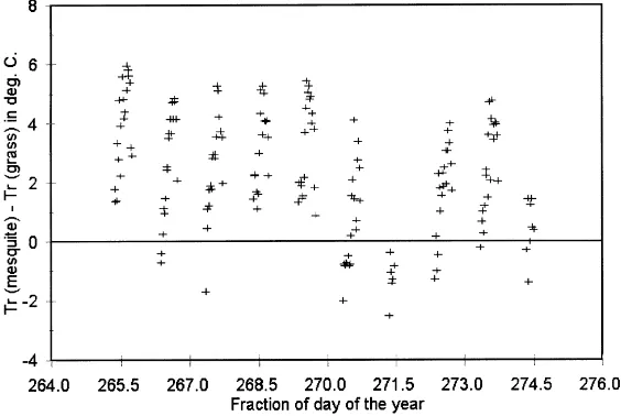
For this particular study, data collected over the mesquite site and the adjacent degraded grassland site are considered. Daytime data over each patch from day of year (DOY) 265 to DOY 274 have been used, which corresponds to the end of the growing season. Fig. 1 presents the differences in measured sensible flux between mesquite and grass patches. This figure shows that there are significant differences between the two patches. The observed differences can be up to 130 W m−2 for sensible heat flux. At first glance,
136 A. Chehbouni et al. / Agricultural and Forest Meteorology 105 (2000) 133–144
Fig. 1. Difference in sensible heat flux values measured over mesquite and over grass.
influences the aerodynamic flow above the canopy) and the differences in the rooting depth between the grass and the mesquite (which determines the avail-ability of soil moisture to the plants). However, in con-trast to the wet season, sensible heat measured over the mesquite during the dry season was larger to that over the grass. The soil in the mesquite was very de-graded with a large proportion of rocks/stones. This leads to high sensible heat flux production especially from the bare soil component. As shown in Fig. 2,
Fig. 2. Difference in radiative surface temperature values measured over mesquite and over grass.
this is the consequence of the fact that under such low soil moisture condition, radiative surface temperature observed over the mesquite was much larger than that of the grass (by up to 6◦C).
3. Modeling approach
H =ρ Cp To−Ta
ra
(1)
whereρ is the air density (kg m−2),C
p the specific
heat of air at constant pressure (J kg−1K−1),T a the
air temperature at a reference height above the surface (K);Tothe aerodynamic surface temperature (K),
de-fined at the mean canopy source,ra the aerodynamic
resistance (sm−1) corrected for the stability/unstability effects following Choudhury et al. (1986). The zero plane displacement height (d) and the roughness length for momentum (zo) are determined following
Choud-hury and Monteith (1988) who fitted simple functions to curves obtained by Shaw and Pereira (1982) from second-order closure theory (the mean drag coefficient was taken to be equal to 0.2). This formulation presents two main advantages compared to the rule of thumb one. First, the vertical structure of the vegetation is taken into account through the use of LAI. Second, the effect of substrate is included in the roughness length calculation.
Sensible heat flux can be rewritten in terms of radiative surface temperature and an excess resistance as
H =ρ Cp Tr−Ta
ra+rex (2)
where Tr is the remotely sensed radiative surface
temperature,rex the additional resistance required to
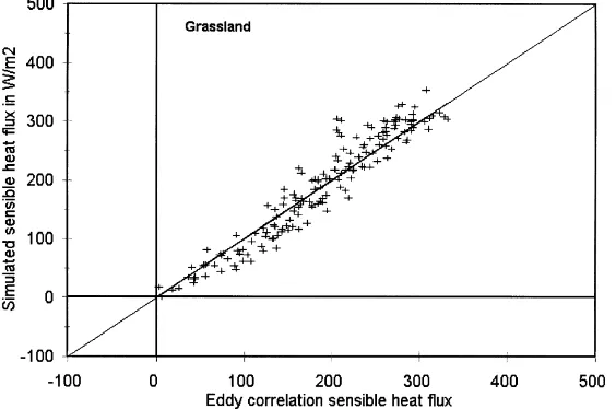
Fig. 3. Comparison between measured and simulated sensible heat fluxes for the grass patch.
take into account the difference between radiative and aerodynamic surface temperature (Hall et al., 1992). Alternatively, Chehbouni et al. (1996) showed that sensible heat flux can also be written using the following equation:
H=ρ Cpβ Tr−Ta
ra
(3)
whereβ is an empirical function of the LAI that re-lates aerodynamic to radiative surface temperature. Based on the investigation of Chehbouni et al. (1996),
β can be expressed for low LAI values as
β= To−Ta Tr−Ta =
1
exp(L/(L−LAI))−1 (4)
Lis a site specific calibration coefficient that has been calibrated using the 1997 data set to a 1.5 (Watts et al., this issue). It is important to emphasize that the excess resistance andβ approaches are functionally equiva-lent. In fact, there is a reciprocal relationship between them (rex =ra(β−1−1)). Therefore, the expression
138 A. Chehbouni et al. / Agricultural and Forest Meteorology 105 (2000) 133–144
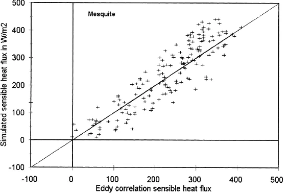
Fig. 4. Comparison between measured and simulated sensible heat fluxes for the mesquite patch.
simulated flux values was 27 W m−2for the grass and
51 W m−2for the mesquite. These results are similar
to those reported in Chehbouni et al. (1996, 1997). It is worthwhile to mention that the excess resistance approach, with an appropriate calibration, can provide similar results, but this is not the thrust of the present study.
3.1. Aggregation procedures
The non-linear nature of the transfer processes dic-tates that only the scalar fluxes can be linearly aver-aged to give area-average values. Therefore, grid-scale sensible heat flux can be obtained as
hHi =fHm+(1−f )Hg (5)
whereHgandHmare the sensible heat flux emanating
from the grass and from the mesquite, respectively, andfis the fraction of the grid covered by the mesquite (about 0.55 here). Grid-scale sensible heat fluxes can also be expressed in terms of the effective surface con-trolling parameters (denoted by angle brackets) using Eqs. (1) and (3) as
hHi =ρCp
hToi −Ta hrai
(6)
hHi =ρCphβihTri −Ta hrai
(7)
According to Shuttleworth (1988) and considering the size of the patches, the heterogeneity of the sur-face can be considereddisorganized(micro-scale het-erogeneity) where the air above the surface is suffi-ciently mixed so that the atmospheric boundary layer responds only to the composite surface structure. Thus, atmospheric forcing parameters are common to both patches and the air temperature and wind speed is as-sumed constant over the grid. The values measured at 10.8 m over the mesquite site have been used here.
By substituting Eq. (1) into Eq. (5) and matching term by term with Eq. (6), effective aerodynamic resis-tance and the effective aerodynamic temperature can be analytically derived as
1
hrai = f
ram
+1−f rag
(8)
hToi = (f T
om/ram)+(1−f )Tog/rag (f/ram)+(1−f )/rag
(9)
where the subscript g stands for grass and m for mes-quite. Similarly, using Eqs. (3), (5) and (7), effective radiative temperature and effectiveβare obtained as
hTri = (
f Trmβm/ram)+βg(1−f )Trg/rag (fβm/ram)+(1−f )βg/rag
(10)
hβi = (fβ
m/ram)+(1−f )βg/rag (f/ram)+(1−f )/rag
Eq. (10) indicates that the effective surface temper-ature is not a direct area-average of the component temperatures but is weighted by the component resis-tancesra and coefficientsβ. It also indicates that, in
principle, the only straightforward case where effec-tive radiaeffec-tive temperature can be precisely equated to composite surface temperature (simple area-weighted component temperatures) is where the ratio (β/ra) are
the same for the entire grid. Similarly Eq. (11) indi-cates that the effectiveβis not an area-weighted aver-age of individual components, but the weighting also involves aerodynamic resistance. One should men-tion that this aggregamen-tion procedure (Eqs. (8)–(11); Scheme 1 Physically based) does not deal directly with the primary surface variables such as roughness length, displacement height, and LAI, involved in the expression of resistance to heat transfer which can be empirically derived from remotely sensed data.
A second aggregation scheme (Scheme 2, semi-empirical) can be derived following the idea suggested by Shuttleworth (1997). He stipulates that “the effec-tive area-average value of land surface parameters is estimated as a weighted average over the component cover types in each grid through that function involv-ing the parameter which most succinctly expresses its relationship with the associated surface flux”. The ap-plication of this rule to sensible heat flux allows the derivation of the following set of relationships between local and effective surface parameters as
ln−2zb− hdi
wherezbis the so-called blending height defined as a
level in the atmosphere where turbulent mixing is suf-ficient so that it can be assumed that the atmosphere has became blended to the differing types of land cover on the ground below (Wieringa, 1986). The blending height was estimated to of the orderl/100,
where l is the characteristic horizontal scale of the different patches making up the grid (roughly about 1 km in the present study). Finally, a third aggregation scheme (Scheme 3, empirical) can be obtained by considering that effective surface temperature and ef-fectiveβcan be obtained as an area weighted average of their corresponding component values and effective aerodynamic resistance can be obtained as a mid-point of series and parallel expressions (Blyth et al., 1993; Blyth and Dolman, 1995; Blyth and Harding, 1995).
Before comparing the performances of the three schemes, it is of interest to analyze their differences and the assumptions associated with each of them. It can be said that the resulting set of relationships between local and effective parameters in Scheme 1 is exact (within the limits of the equation assumed to apply at the local scale) while the relationships asso-ciated with Scheme 3 are purely empirical. Scheme 2 can be considered as semi-empirical. In fact, Eqs. (12) and (13) lead to the formulation of effective aero-dynamic resistance given in Eq. (8) under neutral conditions (Shuttleworth et al., 1997). It is important to notice that Eq. (14) assumes that the relationship between observational and model parameters (here radiative and aerodynamic temperatures) is generic or universal, in the sense that it is can be expressed in a similar manner at both patch and grid scales. Besides this assumption, which needs to be verified, Scheme 2 has a major advantage with respect to Schemes 1 and 2 since it does not require subgrid-scale infor-mation such as individual (component) resistance. In this regard, Scheme 2 makes full use of sur-face parameters that can be obtained from remote sensing.
4. Results
140 A. Chehbouni et al. / Agricultural and Forest Meteorology 105 (2000) 133–144
Fig. 5. Comparison between measured and simulated area-average sensible heat flux using the physically based aggregation procedure (Scheme 1).
area-average flux. However, Chehbouni et al. (this is-sue) showed these area weighted averages compared well with scintillometer measurements which provide a direct estimate of area-average sensible heat flux.
Fig. 5 presents a comparison between simulated and measured fluxes using Scheme 1. It can be seen the correspondence is very good. The RMSE between observed and simulated area-average fluxes was 30 W m−2and the correlation coefficient and the slope
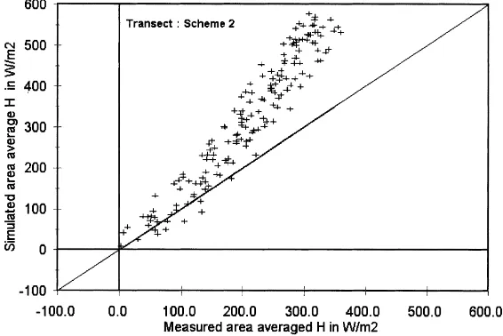
Fig. 6. Comparison between measured and simulated area-average sensible heat flux using the semi-empirical procedure (Scheme 2).
Fig. 7. Comparison between observed and simulated area-average sensible heat flux using the entirely empirical procedure (Scheme 3).
is about more than 2.5 times that of Scheme 1. The correlation coefficient and the slope associated with the linear regression forced to the origin were 0.91 and 1.57, respectively. Fig. 7 presents the same compari-son for Scheme 3. This scheme also presents a slight overestimation of the observed fluxes. The RMSE was about 52 W m−2 and the correlation coefficient
and the slope associated with the linear regression forced to the origin were 0.91 and 1.23, respectively. However, despite the observed overestimation, espe-cially at large flux values, the overall performance of this scheme is correct considering the difficulty in estimating surface fluxes over such complex terrain.
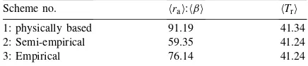
To interpret these results, we present in Table 1, the average surface temperature and the average of the ra-tio between effective values of aerodynamic resistance andβ associated with each of the three aggregation schemes. This table shows that effective and composite surface temperatures (Eq. (16)) are similar despite the expected non-linearity caused by the Planck function.
Table 1
Time average of the ratio between effective values of aerody-namic resistance andβcoefficient and effective radiative surface temperature simulated by each aggregation schemes
Scheme no. hrai:hβi hTri
1: physically based 91.19 41.34
2: Semi-empirical 59.35 41.24
3: Empirical 76.14 41.24
This is of interest since composite surface tempera-ture can be directly measured from remote sensing. The ratiohrai:hβiassociated with Scheme 3 is closer to that of Scheme 1, as compared to Scheme 2. It is precisely this ratio which really determines the trans-fer coefficient. This explains the better performance of Scheme 3 versus Scheme 2.
The influence of changing the fractional area of each patch on the performance of the three schemes has been numerically explored by re-running the three pro-cedures using different proportions of mesquite/grass patches. The results showed that Scheme 2 can per-form similarly to Scheme 3 for large fractional cover of the mesquite patch. In the same vein, the effect of changing vegetation characteristics on the results of the aggregation models model has also been in-vestigated. The results showed that, for example, by dividing the mesquite height by 2 or by multiplying the LAI of the grass by 2, Scheme 3 performed much better than Scheme 2. This may indicate that the re-ported good performance of similar empirical schemes in previous studies might be specific to the conditions where these studies were performed.
5. Discussion and conclusion
142 A. Chehbouni et al. / Agricultural and Forest Meteorology 105 (2000) 133–144
and parameters over heterogeneous surfaces. The results reported are conflicting. Numerical simula-tion studies have emphasized the need to develop theoretically-based aggregation schemes which take into account the non-linear nature of the relation-ships between surface fluxes and surface parameters (Braden, 1994; Lhomme et al., 1994; Chehbouni et al., 1995; Raupach and Finnigan, 1995). However, other studies where field measurements are used sug-gest that the simple empirical aggregation rules may provide accurate estimates of area-average surface fluxes, at least for clear weather conditions (Blyth and Harding, 1995; Arain et al., 1996; Noilhan et al., 1997; Moran et al., 1997; Sellers et al., 1997).
In this study, the issue of estimating area-average sensible heat flux using remotely sensed surface tem-perature over surfaces presenting heterogeneity at both patch and grid-scales has been investigated. The performance of three aggregation schemes ranging from physically-based through semi-empirical to en-tirely empirical has been assessed by comparing mea-sured and estimated area-average sensible heat flux. The results show that the physically based procedure (Scheme 1) provides very good estimates of area-averaged sensible heat flux. However, this procedure requires the knowledge of surface parameters such as radiative temperature and more importantly aerody-namic resistance and β or its equivalent at the patch scale which cannot be obtained from remote sensing at the appropriate time–space scale. The performance of Scheme 3 was reasonable, but this scheme also required patch scale component resistance. This is ac-tually a major limitation of this type of procedure. As pointed out by Shuttleworth et al. (1997), these exact aggregation procedures cannot be routinely applied to a model which is operating at the grid scale in free running predictive mode.
In this regard, the semi-empirical procedure (Scheme 2) seems more practical, but it did not perform very well in the present study. One possible explanation of the poor performance of Scheme 2 might be that the relationships between model and ob-servational variables (here between radiative and aero-dynamic temperatures) are not universal or generic, but are scale dependent. This might only be true for the particular non-linear relationship used here (Eqs. (4) and (14)), but this is unlikely since most, if not all, relationships between observational and model
variables are non-linear. Therefore, to take full advan-tage of the increasing availability of multi-spectral re-motely sensed data, future research should be directed towards building robust relationships between model and observational variables directly at the grid-scale. More importantly, these relationships need to be val-idated using data taken over a range of surface type combinations. It is the intention of the authors to test this approach during the coming years.
Acknowledgements
This research is within the framework of NASA-EOS IDS project (NAGW 2425). Thanks for funds from IRD, CONACyT (Ref. 29340), the French Remote Sensing Program (PNTS), and European Union through VEGETATION program. Additional sup-port was provides by USDA-ARS Global Change Research Program, and NASA grant W-18, 1997. Many thanks to Dr. Y. Nouvellon and the anonymous reviewers for helping to improve this manuscript.
References
Arain, A.M., Michaud, J.D., Shuttleworth, W.J., Dolman, A.J., 1996. Testing of vegetation parameter aggregation rules appli-cable to the Biosphere-Atmosphere Transfer Scheme (BATS) at the Fife site. J. Hydrol. 177, 1–22.
Avissar, R., 1992. Conceptual aspects of a statistical-dynamical approach to represent landscape subgrid-scale heterogeneities in atmospheric models. J. Geophys. Res. 97, 2729–2742. Avissar, R., 1998. Which type of SVAT is needed for GCMs. J.
Hydrol. 50, 3751–3774.
Bastiaansen, W.G.M., Menenti, M., Feddes, R.A., Holtslag, A.A.M., 1998. A remote sensing surface energy balance algo-rithm for land (Sebal). J. Hydrol. 212/213, 198–212. Blyth, E.M., Dolman, A.J., 1995. The roughness length for heat
of sparse vegetation. J. Appl. Meteorol. 34, 583–585. Blyth, E.M., Harding, R.J., 1995. Application of aggregation
models to surface heat flux from Sahelian tiger bush. Agric. For. Meteorol. 72, 213–235.
Blyth, E.M., Dolman, A.J., Wood, N., 1993. Effective resistance to sensible and latent heat flux in heterogeneous terrain. Quart. J. R. Meteorol. Soc. 119, 423–442.
Boulet, G., Kalma, J.D., Braud, I., Vauclin, M., 1990. An asse-ssment of effective land surface parameterisation in regional-scale water balance studies. J. Hydrol. 217, 225–238. Braden, H., 1994. Energy fluxes from heterogeneous terrain:
Cahill, A.T., Parlange, M.B., 1997. On the Brutsaert temperature roughness length model for sensible heat flux estimation. Water Resour. Res. 10, 2315–2324.
Chehbouni, A., Njoku, E.G., Lhomme, J.P., Kerr, Y.H., 1995. An approach for averaging surface temperature and surface fluxes over heterogeneous surfaces. J. Clim. 5, 1386–1393. Chehbouni, A., Lo Seen, D., Njoku, E.G., Monteny, B.A., 1996.
A coupled hydrological and ecological modeling approach to examine the relationship between radiative and aerodynamic surface temperature over sparsely vegetated surfaces. Rem. Sens. Environ. 58, 177–186.
Chehbouni, A., LoSeen, D., Njoku, E.G., Lhomme, J.-P., Monteny, B.M., Kerr, Y.H., 1997. Estimating of sensible heat flux using radiative surface temperature. J. Hydrol. 188, 855–868. Choudhury, B.J., Monteith, J.L., 1988. A four-layer model for
the heat budget of homogeneous land surfaces. Quart. J. R. Meteorol. Soc. 114, 373–398.
Choudhury, B.J., Reginato, R.J., Idso, S.B., 1986. An analysis of infrared temperature observations over wheat and calculation of latent heat flux. Agric. For. Meteorol. 37, 75–88.
Goodrich, D.C., Chehbouni, A., 29 co-authors, 1998. An overview of the 1998 activities of the Semi-Arid Land-Surface program. In: Proceeding of the 1998 American Meteorological Society Meeting, January 1998, Phoenix, AZ, USA.
Hall, G.H., Huemmrich, K.F., Goetz, S.J., Sellers, P.J., Nickeson, J.E., 1992. Satellite remote sensing of surface energy balance: succes, failure and unresolved issues in FIFE. J. Geophys. Res. 97, 19061–19089.
Humes, K.S., Kustas, W.P., Moran, M.S., Nichols, W.D., Weltz, M.A., 1994. Variability of emissivity and surface temperature over sparsely vegetated surface. Water Resour. Res. 30, 1299– 1310.
Koster, R.D., Suarez, M.J., 1992. Modeling the land surface boun-dary in climate models as a composite of independent vegetation stands. J. Geophys. Res. 97, 2697–2715.
Kustas, W.P., Choudhury, B.J., Moran, M.S., Reginato, R.J., Jackson, R.D., Gay, L.W., Weaver, H.L., 1989. Determination of sensible heat flux over sparse canopy using thermal infrared data. Agric. For. Meteorol. 44, 197–216.
Lhomme, J.-P., 1992. Energy balance of heterogeneous terrain: averaging the controlling parameters. Agric. For. Meteorol. 61, 11–21.
Lhomme, J.-P., Chehbouni, A., Monteny, B., 1994. Effective para-meters of surface energy balance in heterogeneous landscape. Bound. Layer Meteorol. 71, 297–309.
Lhomme, J.P., Monteny, B., Troufleau, D., Chehbouni, A., Bauduin, S., 1997. Sensible heat flux and radiometric surface temperature over sparse sahelian vegetation: a model for the kB−1 parameter. J. Hydrol. 189, 839–854.
Li, B., Avissar, R., 1994. The impact of spatial variability of land-surface characteristics on land-surface heat fluxes. J. Clim. 7, 527–537.
McNaughton, K.G., 1994. Effective stomatal and boundary-layer resistances of heterogeneous surfaces. Plant Cell Environ. 7, 1061–1068.
Moran, M.S., Humes, K.S., Pinter, P.J., 1997. The scaling characteristics of remotely-sensed variables for sparsely-vegetated heterogeneous landscapes. J. Hydrol. 190, 337–362.
Moran, M.S., Kustas, W.P., Vidal, A., Stannard, D.I., Blanford, J.H., Nichols, W.D., 1994. Use of ground-based remotely sensed data for surface energy balance evaluation of a semi-arid rangeland. Water Resour. Res. 30, 1339–1349.
Njoku, E.G., Hook, S.J., Chehbouni, A., 1996. Effects of surface heterogeneity on thermal remote sensing of land parameters. In: Stewart, J.B., Engman, E.T., Feddes, R.A., Kerr, Y. (Eds.), Scaling up in Hydrology Using Remote Sensing. John Wiley & Sons, NY, (Chapter 2).
Noilhan, J., Lacarrere, L., 1995. GCM gridscale evaporation from mesoscale modelling: a method based on parameter aggregation tested for clear days of Hapex-Mobilhy. J. Clim. 8, 206– 223.
Noilhan, J., Lacarrere, P., Dolman, A.J., Blyth, E.M., 1997. Defining area-average parameters in meteorological models for land surfaces with mesoscale heterogeneity. J. Hydrol. 190, 302–316.
Pelgrum, H., Bastiaanssen, W.G.M., 1996. An intercomparison of techniques to determine the area-average latent heat flux from in-situ observations: a remote sensing approach using the European Field Experiment in Desertification-Threatened Area data. Water Resour. Res. 32, 2775–2786.
Raupach, M.R., 1991. Vegetation-atmosphere interaction in homogeneous and heterogeneous terrain: some implications of mixed-layer dynamics. Vegetatio. 95, 105–120.
Raupach, M.R., 1993. The averaging of surface fluxes densities in heterogeneous landscapes. In: Bolle, H.J., Feddes, R.A., Kalma, J.D. (Eds.), Exchange Processes at the Land Surface for a Range of Space and Time Scales. Proceedings of the Yokohama Symposuim, IAHS Publ. No. 212, pp. 334–355. Raupach, M.R., Finnigan, J.J., 1995. Scale issues in boundary-layer
meteorology: surface energy balances in heterogeneous terrain. Hydrol. Processes 9, 589–612.
Sellers, P.J., Heiser, M.D., Hall, F.G., Verma, S.B., Desjardins, R.L., Schuepp, P.M., MacPherson, J.I., 1997. The impact of using area-averaged land surface properties-topography, vegetation condition, soil wetness-in calculations of intermediate scale (approximately 10 km2) surface-atmosphere heat and moisture fluxes. J. Hydrol. 190, 269–301.
Shaw, R.H., Pereira, A.R., 1982. Aerodynamic roughness of a plant canopy: a numerical experiment. Agric. For. Meteorol. 26, 51–65.
Shuttleworth, W.J., 1988. Macrohydrology — the new challenge for process hydrology. J. Hydrol. 100, 31–56.
Shuttleworth, W.J., 1991. The modellion concept. Rev. Geophys. 29, 585–606.
Shuttleworth, W.J., 1997. Hydrological models, regional evaporation and remote sensing: let’s start simple and maintain perspective. In: Sorooshian, S., Gupta, H.V., Rodda, J. (Eds.), Land Surface Processes in Hydrology: Trials and Tribulations of Modeling and Measuring. Nato ASI series, Vol. I46, Springer, Berlin, Heidelberg.
Shuttleworth, W.J., Yang, Z.-L., Arain, M.A., 1997. Aggregation rules for surface parameters in global models. Hydrol. Earth Syst. Sci. 2, 217–226.
144 A. Chehbouni et al. / Agricultural and Forest Meteorology 105 (2000) 133–144
surface temperature relationship for 8 semi-arid areas. J. Appl. Meteorol. 33, 1110–1117.
Sun, J., Mahrt, L., 1995. Determination of surface fluxes from the surface radiative temperature. J. Atm. Sci. 52, 1096–1106. Troufleau, D., Lhomme, J.-P., Monteny, B., Vidal, A., 1997.
Sensible heat flux and radiometric surface temperature over sparse sahelian vegetation: is the kB−1 a relevant parameter. J. Hydrol. 189, 815–838.
Watts, C.J., Chehbouni, A., Rodriguez, J.-C., Kerr, Y.H., Hartogensis, O., De Bruin., H.A.R., 2000. Comparison of sensible heat flux estimates using AVHRR with scintilllometer measurements over semi-arid grassland in northwest Mexico. Agric. For. Meteorol. 105, 81–89.