LONG-TERM SOIL MOISTURE TIME SERIES ANALYSES BASED ON ACTIVE
MICROWAVE BACKSCATTER MEASUREMENTS
W. Wagner, C. Reimer, B. Bauer-Marschallinger, M. Enenkel, S. Hahn, T. Melzer, V. Naeimi, C. Paulik, W. Dorigo
Vienna University of Technology (TU Wien), Department of Geodesy and Geoinformation (GEO), Vienna, Austria – [email protected]
KEY WORDS: Soil moisture, scatterometers, land surface dynamics
ABSTRACT:
Active microwave sensors operating at lower microwave frequencies in the range from 1 to 10 GHz provide backscatter measurements that are sensitive to the moisture content of the soil. Thanks to a series of European C-band (5.3 GHz) scatterometers, which were first flown on board of the European Remote Sensing satellites ERS-1 and ERS-2, and later on board of MetOp-A and MetOp -B, we are now in the possession of a long-term soil moisture time series starting in 1991. The creation of globally consistent long-term soil moisture time series is a challenging task. The TU-Wien soil moisture algorithm is adopted to tackle these challenges. In this paper we present two methodologies that were developed to ensure radiometric stability of the European C-band scatterometers. The objective of sensor intra-calibration is to monitor and correct for radiometric instabilities within one scatterometer mission, while sensor inter-calibration aims to remove radiometric differences across several missions. In addition, a novel vegetation modelling approach is presented that enables the estimation of vegetation parameters for each day across several years to account for yearly to longer-term changes in vegetation phenology and land cover.
1. INTRODUCTION
Environmental monitoring, particularly in the microwave spectrum, has a long heritage in the European earth observation programme. With the launch of the European Remote Sensing satellite ERS-1 in 1991, the first European C-band scatterometer (ESCAT) was placed in orbit (Attema, 1991). At this time, ESCAT was the most sophisticated microwave instrument ever developed by the European Space Agency (ESA), providing new insights into the land surface dynamics of the Earth. Due to the great success of the ERS-1 mission, the follow-up mission ERS-2 was launched in 1995, with almost identical payload as its precursor, to guarantee the continuity of C-band scatterometer observations (Lecomte, 1998). ERS-1 was decommissioned after 9 years of operations in the year 2000, ERS-2 in 2011 after almost 16 years in space. However, already by the end of 2006, ESA and the European Organisation for the Exploitation of Meteorological Satellites (EUMETSAT) launched the Meteorological Operational satellite MetOp-A, followed by MetOp-B in 2012, as two of three satellites within EUMETSAT’s Polar System (Figa-Saldaña et al., 2002; Klaes et al., 2007). One instrument on-board both satellites is the Advanced Scatterometer (ASCAT), the successor instrument of ESCAT with a technical enhanced sensor design, attributable to the considerable evolution in the capabilities of spaceborne hardware (Gelsthorpe et al., 2000).
ESCAT on-board ERS-1/2 is a C-band fan-beam scatterometer with three sideways looking vertically polarised antennas operating at 5.3 GHz. One antenna is looking perpendicular to the right side of the satellite track (Mid-Beam), one is looking forward at 45° angle (Fore-Beam) and one is looking backward at 135° angle (Aft-Beam) illuminating a single 500 km wide swath. The instrument technical design of the ASCAT is similar to that of ESCAT, but with an enhanced system geometry of two swaths separated from the satellite ground track by about 336 km to the left and right sight. As a result, the twin swath
geometry of ASCAT, with three antennas within each swath, offers twice the coverage of ESCAT. Furthermore, linear frequency modulated pulses are transmitted, permitting longer pulse durations at a relatively low peak power.
The primary objective of these European C-band fan-beam scatterometers is the retrieval of wind speed and direction over the oceans (Long, 1985; Stoffelen, 1998). Over land, the backscattered signal being recorded contains substantial information about soil moisture, surface roughness and vegetation. A number of authors proposed methods for retrieving soil moisture from ERS-1/2 ESCAT backscatter measurements (Frison et al., 1998; Magagi and Kerr, 1997; Pulliainen et al., 1998; Woodhouse and Hoekman, 2000; Zine et al., 2005; Zribi, 2003). Most approaches make use of inversion methods based on the physical approximation of the scattering mechanism to account for surface roughness and vegetation cover (Attema and Ulaby, 1978; Fung et al., 1992; Oh et al., 1992). Limitations of these retrieval concepts appear in their physical validity at larger scales and their parameterisation. Wagner et al. (1999a, 1999b) presented a physically motivated change detection method, hereafter referred to as TU-Wien soil moisture model, to overcome possible limitations of the inversion methods. Initially tailored to ESCAT, the TU-Wien soil moisture model was successfully transferred to ASCAT incorporating minor adaptations and improvements (Bartalis et al., 2007; Naeimi et al., 2009).
2. INSTRUMENT STABILITY OF ESCAT AND ASCAT
The TU Wien soil moisture model is from a mathematical point of view less complex than semi-empirical inversion methods based upon the Cloud Model. Soil moisture retrievals can be estimated directly from the scatterometer measurements without the need of an iterative adjustment process. One disadvantage of the method is that it is necessary to calibrate its model parameters using long-term backscatter time-series to implicitly account for land cover, surface roughness and many other effects. Thanks to the long heritage of European scatterometer observations, a robust estimation of such model parameters is ensured individually for ESCAT and ASCAT. However, a key aspect in the estimation of accurate model parameters is the radiometric stability of the utilised backscatter measurements over long time periods.
Main mission events such as the gyroscope failure of ERS-2 ESCAT in 2001 (Crapolicchio et al., 2012) or the regular calibration campaigns performed for ASCAT (Wilson et al., 2010) may affect the overall long-term instrument stability. Radiometric instabilities of the instrument will affect the TU-Wien soil moisture retrieval by degrading the parameter estimation precision. Hence, a method was recently developed to monitor the long-term radiometric stability of ESCAT and ASCAT (Reimer, 2014). The developed method closely follows the principle of relative calibration of scatterometers by making use of natural calibration targets on the Earth’s surface (Anderson et al., 2012; Crapolicchio et al., 2012; Lecomte and Wagner, 1998). Natural calibration targets are featured by a temporal stable and homogeneous backscatter response over an extensive area like the Amazon and Congo Rainforest. The employed strategy is referred to as sensor intra-calibration aiming to detect and correct for potential radiometric instabilities of a single scatterometer mission.
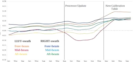
Results of this analyses confirm the good quality of operational disseminated MetOp-A ASCAT Level 1 backscatter data. The radiometric stability of ASCAT was found to be 0.047 dB on average over all antenna beams within the mission period from 2007 to 2013. On 9September 2009 an important change in the operational Level 1 processing chain was implemented at EUMETSAT, affecting the stability of the left swath mid-beam antenna of ASCAT as shown in Figure 1. Moreover, the implementation of a new calibration table, derived from the 2010 transponder calibration campaign, into ground processing chain is noticeable from August 2011 onwards, having an impact on the overall instrument stability (EUMETSAT, 2011).
Figure 1: Radiometric stability of ASCAT from 2007 to 2013
With respect to ESCAT, equivalent analyses were performed based on the available re-processed data archive computed with the Advanced Scatterometer Processing System. This system is a state-of-the-art Level 1 scatterometer processor (ASPS), specifically engineered to re-process ERS-2 ESCAT data recorded in zero-gyro mode (ZGM) and data acquired in the so called “Regional Mission Scenario”(Crapolicchio et al., 2012; De Chiara et al., 2007). The average radiometric stability of ESCAT was determined with 0.024 dB for the mission period from May 1997 to February 2003. Nevertheless, a decrease of the instrument stability was detected in the aft-beam antenna of ESCAT. This instability is related to the ZGM piloting of ERS-2 from February 2001 onwards, with a mean aft-beam stability value of 0.05 dB in contrast to the two other antenna beams.
By taking full advantage of the developed sensor intra-calibration strategy, it was possible to further improve the radiometric stability of ASCAT and ESCAT. Figure 2 illustrates the achieved instrument performance after sensor intra-calibration. With reference to ASCAT, an improved stability of 0.015 dB was attained, whereas in terms of ESCAT a value of 0.017 dB was achieved, respectively. The enhanced instrument stability of ESCAT and ASCAT will have a positive impact on the TU-Wien model parameter estimation and will additionally improve the final soil moisture retrievals.
Figure 2: ASCAT radiometric stability after sensor intra-calibration
3. INTER-CALIBRATION OF ESCAT AND ASCAT
In view of the generation of a long-term soil moisture time-series covering the last 23 years, scatterometer observation from various instruments need to be merged to a single consistent data record. This task prerequisites a careful characterisation of the instrument performance of each individual scatterometer mission with respect to the radiometric calibration. Similarities in the instrument technical design of ESCAT and ASCAT, encourage the fusion of these missions towards a long-term European scatterometer data archive. Hence, a sensor inter-calibration method was introduced at TU-Wien to quantify radiometric differences between these European C-band scatterometer missions (Reimer, 2014).
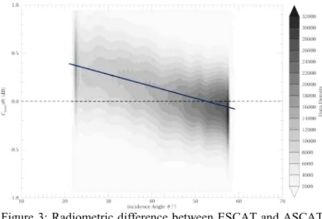
Figure 3: Radiometric difference between ESCAT and ASCAT aft-beam observations
Figure 3 depicts the detected radiometric difference of the aft-beam antenna of ESCAT with reference to ASCAT. Overall, the observed biases are ranging from 0.39 dB at the lowest incidence angle to -0.08 dB at the highest incidence angle, respectively. Applying the developed sensor inter-calibration approach result in radiometric adjusted backscatter values as shown in Figure 4 in case of the ESCAT aft-beam antenna. Achieved residual radiometric differences between ESCAT and ASCAT vary between 0.04 dB and -0.04 dB, indicating a successful adjustment and encourage the merging of these data sets to the demanded long-term data. In addition, it will be possible to derive combined model parameters of the TU-Wien soil moisture model from ESCAT and ASCAT. Consequently, a consistent long-term soil moisture dataset could be generated covering at least 23 years of global records.
Figure 4: Radiometric difference between ESCAT inter-calibrated backscatter observations and ASCAT
4. MODELLING OF VEGETATION EFFECTS
Backscatter observations depend strongly on the incidence angle. One assumption in the TU-Wien soil moisture model is that this dependency can be accurately modelled by a 2nd order polynomial. Furthermore, it is assumed that the 1st and 2nd derivative of this polynomial depend on the vegetation state and surface roughness, while the 0th moment, the intercept, depends on the soil moisture. An increase in soil moisture shifts the curve upwards and a decrease in soil moisture shifts it downwards. Thus, in the TU-Wien soil moisture model the 1st and 2nd
derivative of the 2nd order polynomial, known as slope and curvature, are crucial parameters to estimate. Slope and curvature mediate the effect of vegetation on the backscatter versus incidence angle relationship. As an example, for sparse
vegetation the curve tends to drop off rapidly with increasing incidence angle, while for fully grown vegetation it becomes less steep or almost horizontal in the case of the rainforests.
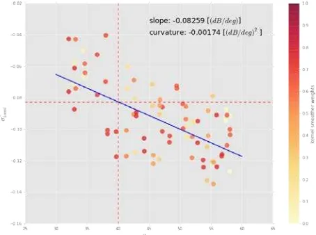
Slope and curvature are the 1st and 2nd derivative of the 2nd order polynomial modelling the backscatter-incidence angle dependency. Hence, the first derivative of this model is a linear function, in which the intercept and slope coefficients represent the crucial slope and curvature parameters of the soil moisture model. It is worth noting that the dependency on the unknown soil moisture vanished in first derivative of the backscatter-incidence angle model. As a consequence, slope and curvature parameters are determined as the coefficients of a linear fit to the so called local slopes (Figure 5). Local slopes represent the 1st derivative of the backscatter versus incidence angle dependency and are derived as the difference quotients between fore- and mid-beam, and aft- and mid-beam, respectively (Wagner et al., 1999a).
Figure 5: Estimation example of slope and curvature parameters by fitting a linear function to the so called local slopes
In the current implementation of the TU-Wien soil moisture model, known as WAter Retrieval Package (WARP) 5.5, it is assumed that the vegetation state is always the same at the same day of the year. Accordingly the estimated parameters do not change inter-annually and are referred to as yearly slope and yearly curvature. Yearly slope and curvature values are computed for each day of the year. Hence for each location on the Earth’s surface there are 365 parameter pairs.
day of the year. Finally, slope and curvature parameters are determined as the mean of simulated values, given a large quasi-random number of window lengths ranging between 2 and 12 weeks as input of the simulation. Yearly slope and yearly curvature are derived by extrapolation of the parameters determined at the 27 equidistant days to the remaining days of the year.
Drawbacks of the current slope/curvature parameter estimation are its high computational cost in order to compute the various Monte Carlo simulations and the fact that inter-annual changes in vegetation are not taken into account. To overcome these limitations Melzer (2013) proposed a novel approach to estimate slope and curvature parameters on a daily base, with the aim to account for changing vegetation effects across different years. The objective was to develop an algorithm that is faster than the Monte Carlo simulation approach, so that it becomes possible to calculate slope/curvature parameter pairs annually on a daily base. In a first step, the costly averaging over the different Monte Carlo simulations was removed by conducting research with focus on the optimal choice of time window length. Ultimately, an adaptive, data-driven, time window selection scheme was foreseen, but rejected due to the relatively high noise variance of the local slopes. It was found that a fixed time window half-length of 21 days strikes a good balance between bias and variance of the estimates.
Furthermore, three different linear regression methods were evaluated for a robust estimation of the model parameters. The three linear regression method options were: Simple Robust Fit, Least Median of Squares and Local Linear Regression. In terms of the Simple Robust Fit (SR) method, a standard linear least squares fit is computed repeatedly. After each iteration step, points with residuals greater than twice the estimated standard deviation are identified as outliers and removed. The iteration terminates when the magnitude of change of the parameters is below a defined threshold. Least Median of Squares (LMS) is a robust regression paradigm, capable to deal with extreme outliers. The idea is to select those parameters that minimise the median of the residuals. However, both methods have weaknesses in estimating a smooth functional behaviour of the parameters. Additionally, a main disadvantage of the LMS method is the high computational cost.
Figure 6: Slope and Curvature estimation using LLR with an Epanechnikov kernel smoother for a single evaluation day and a time window half-length of 21 days.
The third method is known as Local Linear Regression (LLR) which is a kernel smoother method computing locally weighted linear fits (Hastie et al., 2003). Normally, weights are decreasing as a function of the distance with respect to the evaluation point. In our case, the fit is performed over the whole incidence angle range, by weighting the different contributions according to their distance in time from the evaluation day (Figure 6). As a smoothing kernel the Epanechnikov kernel was selected with a time window half-width of 21 days. Since this approach estimates daily slope and curvature parameters in a smooth fashion as a function of time with relative low computational cost, the current implemented Monte Carlo simulation is replaced with this novel method.
A first comparison between the yearly and daily slope/curvature estimates, as shown in Figure 7, indicated distinct differences. The yearly slope/curvature exhibits a quasi-unimodal structure, which is apparent in the daily parameters estimates as well. Provided the differences seen in the yearly and daily estimates are in fact related to vegetation changes across the different years, the quality of the soil moisture retrieval could be improved by integrating the daily slope and daily curvature parameters into the model.
Figure 7: Yearly slope / curvature (red) versus daily slope / curvature (blue) estimates
5. CONCLUSION
and adopted to consider annual vegetation changes. The newly introduced vegetation modelling approach is novel in terms of deriving a vegetation parameter estimate for each day in a long-term data record. Hence it is anticipated that inter-annual and longer-term changes in vegetation and land cover could be detected and attributed in the soil moisture retrieval to further improve the retrieval performance.
ACKNOWLEDGEMENTS
We acknowledge the funding by ESA through the SCIRoCCo (http://scirocco.sp.serco.eu/) and Climate Change Initiative Soil Moisture (http://www.esa-soilmoisture-cci.org/) projects, and by EUMETSAT through H-SAF (http://hsaf.meteoam.it/).
REFERENCES
Anderson, C., Figa, J., Bonekamp, H., Wilson, J.J.W., Verspeek, J., Stoffelen, A., Portabella, M., 2012. Validation of Backscatter Measurements from the Advanced Scatterometer on MetOp-A. J. Atmos. Oceanic Technol. 29, 77–88. doi:10.1175/JTECH-D-11-00020.1
Attema, E.P.W., 1991. The Active Microwave Instrument on-board the ERS-1 satellite. Proceedings of the IEEE 79, 791 – 799. doi:10.1109/5.90158
Attema, E.P.W., Ulaby, F.T., 1978. Vegetation modeled as a water cloud. Radio Science 13, 357–364. doi:10.1029/RS013i002p00357
Bartalis, Z., Wagner, W., Naeimi, V., Hasenauer, S., Scipal, K., Bonekamp, H., Figa, J., Anderson, C., 2007. Initial soil moisture retrievals from the METOP-A Advanced Scatterometer (ASCAT). Geophysical Research Letters 34. doi:10.1029/2007GL031088
Crapolicchio, R., De Chiara, G., Elyouncha, A., Lecomte, P., Neyt, X., Paciucci, A., Talone, M., 2012. ERS-2 Scatterometer: Mission Performances and Current Reprocessing Achievements. IEEE Transactions on Geoscience and Remote Sensing. doi:10.1109/TGRS.2011.2179808
De Chiara, G., Crapolicchio, R., Lecomte, P., 2007. ERS-1/2 Scatterometer new products: mission reprocessing and data quality improvement. Presented at the Space for Hydrology Workshop.
EUMETSAT, 2011. ASCAT Product Guide [WWW Document]. EUMETSAT: ASCAT Product Guide. URL http://oiswww.eumetsat.org/WEBOPS/eps-pg/ASCAT/ASCAT-PG-0TOC.htm
Figa-Saldaña, J., Wilson, J.J.W., Attema, E., Gelsthorpe, R., Drinkwater, M.R., Stoffelen, A., 2002. The advanced scatterometer (ASCAT) on the meteorological operational (MetOp) platform: A follow on for European wind scatterometers. Canadian Journal of Remote Sensing 28, 404– 412. doi:10.5589/m02-035
Frison, P.L., Mougin, E., Hiernaux, P., 1998. Observations and Interpretation of Seasonal ERS-1 Wind Scatterometer Data over Northern Sahel (Mali). Remote Sensing of Environment 63, 233–242. doi:10.1016/S0034-4257(97)00137-5
Fung, A.K., Li, Z., Chen, K.S., 1992. Backscattering from a randomly rough dielectric surface. IEEE Transactions on
Geoscience and Remote Sensing 30, 356–369. doi:10.1109/36.134085
Gelsthorpe, R.., Schied, E., Wilson, J.J.., 2000. ASCAT – Metop’s Advanced Scatterometer. ESA Bulletin 19–27.
Hastie, T., Friedman, J., Tibshirani, R., 2003. The elements of
statistical learning : data mining, inference, and prediction.
Springer, New York, NY [u.a.].
Klaes, K.D., Cohen, M., Buhler, Y., Schlüssel, P., Munro, R., Engeln, A., Clérigh, E., Bonekamp, H., Ackermann, J., Schmetz, J., Luntama, J.-P., 2007. An Introduction to the EUMETSAT Polar system. Bulletin of the American Meteorological Society 88, 1085–1096. doi:10.1175/BAMS-88-7-1085
Lecomte, P., 1998. ERS scatterometer instrument and the on-ground processing of its data, in: European Space Agency, (Special Publication) ESA SP. pp. 241–260.
Lecomte, P., Wagner, W., 1998. ERS Wind Scatterometer Commissioning & In-Flight Calibration. EUROPEAN SPACE AGENCY-PUBLICATIONS-ESA SP 424, 261–270.
Long, A.., 1985. Towards a C-band radar sea echo model for the ERS-1 scatterometer (Proceedings of a conference on spectral signatures No. ESA SP-247), European Space Agency Spec. Publ. Les Arc, France.
Magagi, R.D., Kerr, Y.H., 1997. Retrieval of soil moisture and vegetation characteristics by use of ERS-1 wind scatterometer over arid and semi-arid areas. Journal of Hydrology 188-189, 361–384. doi:10.1016/S0022-1694(96)03166-6
Melzer, T., 2013. Vegetation Modelling in WARP 6.0, in: Proceedings of the 2013 EUMETSAT Metereological Satellite Conference.
Naeimi, V., Scipal, K., Bartalis, Z., Hasenauer, S., Wagner, W., 2009. An Improved Soil Moisture Retrieval Algorithm for ERS and METOP Scatterometer Observations. IEEE Transactions on Geoscience and Remote Sensing 47, 1999–2013. doi:10.1109/TGRS.2008.2011617
Oh, Y., Sarabandi, K., Ulaby, F.T., 1992. An empirical model and an inversion technique for radar scattering from bare soil surfaces. IEEE Transactions on Geoscience and Remote Sensing 30, 370–381. doi:10.1109/36.134086
Pulliainen, J.T., Manninen, T., Hallikainen, M.T., 1998. Application of ERS-1 wind scatterometer data to soil frost and soil moisture monitoring in boreal forest zone. IEEE Transactions on Geoscience and Remote Sensing 36, 849–863. doi:10.1109/36.673678
Reimer, C., 2014. Calibration of space-borne Scatterometers: Towards a consistent climate data record for Soil Moisture Retrieval (Master Thesis). Vienna University of Technology, Vienna.
Stoffelen, A., 1998. Scatterometry. University of Utrecht, Utrecht.
Wagner, W., Noll, J., Borgeaud, M., Rott, H., 1999b. Monitoring soil moisture over the Canadian Prairies with the ERS scatterometer. IEEE Transactions on Geoscience and Remote Sensing 37, 206–216. doi:10.1109/36.739155
Wilson, J.J.W., Anderson, C., Baker, M.A., Bonekamp, H., Saldaña, J.F., Dyer, R.G., Lerch, J.A., Kayal, G., Gelsthorpe, R.V., Brown, M.A., Schied, E., Schutz-Munz, S., Rostan, F., Pritchard, E.W., Wright, N.G., King, D., Onel, U., 2010. Radiometric Calibration of the Advanced Wind Scatterometer Radar ASCAT Carried Onboard the METOP-A Satellite. IEEE Transactions on Geoscience and Remote Sensing 48, 3236– 3255. doi:10.1109/TGRS.2010.2045763
Woodhouse, I.H., Hoekman, D.H., 2000. Determining land-surface parameters from the ERS wind scatterometer. Geoscience and Remote Sensing, IEEE Transactions on 38, 126–140.
Zine, S., Jarlan, L., Frison, P., Mougin, E., Hiernaux, P., Rudant, J., 2005. Land surface parameter monitoring with ERS scatterometer data over the Sahel: A comparison between agro-pastoral and agro-pastoral areas. Remote Sensing of Environment 96, 438–452. doi:10.1016/j.rse.2005.04.012