IMPACT ASSESSMENT OF TROPICAL CYCLONE HUD HUD ON COASTAL REGION
OF VISAKHAPATNAM, ANDHRA PRADESH, INDIA
Vivek G a, * , Srinivasa Kumar T b
a Dept. of Civil Engineering, SRM University, Kattankulathur, Kancheepuram District, Chennai-603203, India -
b INCOIS, Hyderabad, Telangana-500090, India - [email protected]
KEY WORDS: Track Map, NDVI Classification Map, Inundation Map, Statistical Table
ABSTRACT:
Tropical cyclone is a rapidly rotating storm system characterized by a low pressure center, strong winds, and a spiral arrangements of thunderstorms that produce heavy rain. Tropical cyclones typically form over large bodies of relatively warm water. On 6th October
2014 Hud Hud originates from a low pressure system that formed under the influence of an upper air cyclonic circulation in the Andaman Sea. On 9th October 2014 the IMD department classified the Hud Hud as a very severe cyclonic storm on IMD scale and
category 4 on Staffir-Simpson scale. The cyclone hit the coast of Visakhapatnam on 12th October 2014 at wind speed of 175 km/h
which caused extensive damage to the city and the neighbouring districts. The damage caused by Cyclone Hud Hud not only changed the landscape of the port city, but also made it the first city in the country to be directly hit by a cyclone since 1891 as per the records of the IMD. The remote sensing technique used here is NDVI. NDVI will separate vegetation and non-vegetation part. The NDVI will be classified in ERDAS and calculated the area using ARCGIS. The satellite data of 4th October 2014 show s before the cyclone,
14th October 2014 shows after the cyclone and 7th December 2014 after two month of cyclone.
1. INTRODUCTION
1.1 General Introduction
A tropical cyclone is a rapidly rotating storm system characterized by a low-pressure center, strong winds, and a spiral arrangement of thunderstorms that produce heavy rain. Similar to tropical cyclones, extra-tropical storms cause an offshore rise of water. However, unlike most tropical cyclone storm surge, extra-tropical storms can cause higher water levels across a large area for longer periods of time, depending on the system. This is due to many factors, such as storm size and different steering winds, which could keep a system in a storm-surge prone area for longer periods of time. The main objective of this study is the change detection. Due to the cyclone the vegetation has been affected very large, many trees are uprooted. For assessing the vegetation damage the technique used here is the NDVI classification technique. This technique gives better result as compare to other technique like supervised and unsupervised classification. The normalized difference vegetation index (NDVI) is a simple graphical indicator that can be used to analyse remote sensing measurements, and assess whether the target being observed contains live green vegetation or not. The classification of NDVI image is easy as compare to supervised and un-supervised classification because if the resolution of the satellite image is not good, it will be difficult to select the region of interest from the image. 1.2 Background of Study
Visakhapatnam (Vizag) is the largest city in the Indian state of Andhra Pradesh. Visakhapatnam is located 370 kilometres north east of the proposed state capital of Amaravati and 701
kilometres of Hyderabad, the common capital of Andhra Pradesh and Telangana. It is situated between the Eastern Ghats to its west and the Bay of Bengal to its east, bordering on the north with the state of Orissa and Vizianagaram district and East Godavari District to the south. Its periphery consists of plains along the coast line while the interiors boast of the beautiful hills of the Eastern Ghats which surround it on the North and the West. This region is also called the Agency Division. It occupies an area of approximately 11,161 km2 (4,309 sq. mi). Since it is near to the coast, it is most vulnerable to cyclonic activities and it is categorizes as very high risk zone.
1.3 Climatic Change Studies of Visakhapatnam
A comprehensive study on vulnerability of a coastal city like Visakhapatnam to rise in sea level, storm surge, and other climatic changes has been made by The Energy and Resources Institute. A database management system (DBMS) has also been created on climate resilience. The one-and-a-half-year study, taken up by TERI with the support of USAID’s Climate Change Resilient Development Programme (CCRD) under climate resilient infrastructure services component, has created a database that could be used by the Greater Visakhapatnam Municipal Corporation. In its climate analysis, rainfall pattern, observed and projected sea level rise, pattern of cyclone events have been considered and corroborated with digital elevation models to identify vulnerable hotspots in the city.
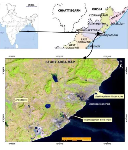
1.4 Study Area
Figure 1. Study Area
The study area is most vulnerable to cyclonic activities and it is categorizes as very high risk zone. The city coordinates lies between 17.6883° N latitude, and 83.2186° E longitude. Its periphery consists of plains along the coast line while the interiors boast of the beautiful hills of the Eastern Ghats which surround it on the North and the West. This region is also called the Agency Division. It occupies an area of approximately 11,161 km. (Figure 1)
2. DATA AND METHODOLOGY
2.1 Data Source
Remote sensing data from USGS website was downloaded. The USGS satellite Landsat 8 of Multi Spectral Scanner (MSS) was selected for this study for the better identification of settlement, vegetation and water bodies. Three different dates of satellite image was selected and downloaded.(Table1)
Table 1. Details of the Data used in this Study
2.2 Track Map
The track map is used for tracking the cyclone. It gives the information about direction of the cyclone. The track map used here will give the basic information like date and time of the cyclone reaches near to the coast. (Figure 3)
Figure 2. Cyclone track map
2.3 Methodology
The (Figure 3) explains the methodology. The tack map is used as a reference map for selecting the base map. Once the base map is selected the NDVI is created and classified them as sparse, dense, water and settlement. Once the features are classified, calculate the area in km2 in ARCGIS.
2.4 Base Map
Using the track map the base map has been generated. Base map will give the basic information about surface features like vegetation, water, road and settlement etc. The base map of 4th Oct 14 will give the condition before the cyclone, 20th
Oct 14 will give after the cyclone and 7th Dec 14 after a two
month cyclone passes. (Figure 4)
a b
c
Figure 4. (a) Base map for before cyclone 4 Oct 14 (b) Base map for after cyclone 20 Dec 14 (c) Base map for after a month of cyclone 7 Dec 14
3. RESULTS AND DISCUSSION
3.1 NDVI: Normalised differential vegetation index
The normalized difference vegetation index (NDVI) is a simple graphical indicator that can be used to analyse remote sensing measurements, and assess whether the target being observed contains live green vegetation or not. Here NDVI is created using the model maker in ERDAS. The input will be layer stacked image and using the conditional statement, the values are simplify and image will be enhanced. The condition used here is:
Band 4 – Red
Band 5 – Near Infrared
EITHER 0 IF ((band 5 + band 4) ==0) OR (band 5 – band 4) / (band 5 + band 4) OTHERWISE
After processing the NDVI will be created. (Figure 5) 3.2 NDVI Classification Map
After the NDVI is extracted, the image will be classified in ERDAS. The classification will be classified as sparse vegetation, dense vegetation, settlement and water. In the attribute table assign appropriate colour for different features. After classification open the image in ARCGIS and calculate the area of features in square km.
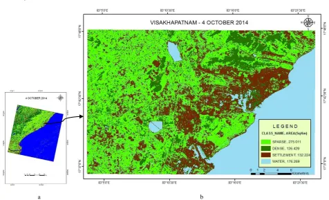
3.2.1 4th Oct 2014 – The classification has been done for
showing the pre event condition of that area. The features are classified as sparse, dense, water and settlement and respective area is calculated. (Figure 6)
3.2.2 20th Oct 2014 – the classification has been done for
showing the post event condition of that area. The changes will be identified by calculating the area in KM2. (Figure 7) 3.2.3 7th Dec 2014 – the classification has been done for
showing after a two month of cyclone passes. The actual impact will be get to know by calculating the area. (Figure 8) 3.3 Statistical Table
3.3.1 Before Cyclone
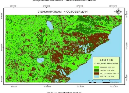
This shows that sparse vegetation is 275.011 km2, dense vegetation is 126.429 km2, settlement is 132.224 km2 and water is 176.269 km2. These are the condition before the cyclone hits the coast of Visakhapatnam. (Table 2)
CLASS NAME AREA – KM2
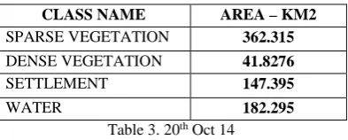
The area is calculated for after a cyclone passes. The result shows that sparse vegetation is increased but dense vegetation is decreased. This is due to trees uprooting. During the cyclone trees are mostly affected. The water level is also increased which is due to the heavy rainfall. Maximum rainfall recorded is 550mm over the ocean and 200 - 250 mm over the land. Rise in the area of settlement is due to debris or raw materials from the buildings. (Table 3)
CLASS NAME AREA – KM2
is the change of rate in settlement? The data shows there is slight increase in sparse vegetation, the dense vegetation is decreased, settlement is decreased, and water level is decreased. After a two month of cyclone passes the actual impact is identified. (Table 4)
CLASS NAME AREA – KM2
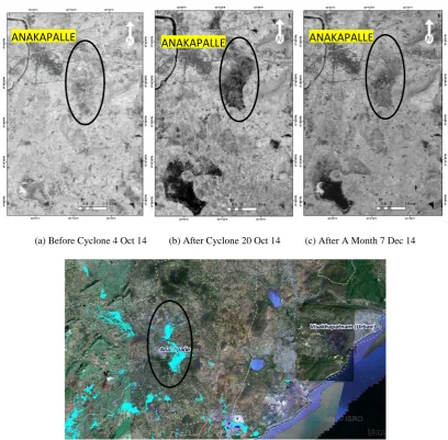
Inundation events are among most frequent, costly and deadly coastal hazards. There are four primary causes of significant inundation: storm surge, tsunamis, inland flooding and shallow coastal flooding. Due to the tropical cyclone Hud Hud in some area is affected by the inundation. There is a place anakapalle near to the study area, which is affected by inundation. In figure (a) the highlighted area shows before the cyclone (b) show the area is affected by the flood (c) shows the condition of that area after a month of cyclone passes. This type of inundation is occur due to the heavy rain from a storm. (Figure 9)
4. CONCLUSION
Cyclone Hud Hud caused severe damages near to the coastal region of Visakhapatnam, which lead to human loss, injuries, house damages, road damages etc. When the tropical cyclone comes necessary step should be taken like evacuating the place when the government launches storm bulletins, reach to
the safe place as soon as possible. Using the NDVI classification technique the impact assessment has been done.
5. RECOMDATION
The Landsat 8 image has been used here which is 30 m resolution. While doing supervised classification result will not be appropriate. While choosing the region of interest the pixel can be mixed with other pixels which lead to improper classification and the accuracy will be less. While using the NDVI classification technique the result will be appropriate and better than supervised classification. There will be less chance of pixel mixes because the NDVI will separate vegetation and non-vegetation part, which can be classified easily. The supervised classification can give better result if we use the high resolution satellite data like IKONOS and QUICKBIRD. The comparison between supervised classification (minimum distance method) and NDVI classification technique has been given . (Figure 10)
6. WORK IN PROGRESS
The CVI (Costal vulnerability index) for Visakhapatnam will be created. Then risk rating will be assigned like very high, high, moderate, low. It will help us to know the coastal geomorphology, slope, shoreline changing rate.
7. ACKNOWLEDGEMENT
I take this opportunity to express my profound gratitude to my guide Dr. T. Srinivasa Kumar Scientist F, R S Mahendra Scientist D, Prakash Mohanthy Project Scientist B, (INCOIS) who help me throughout in completing of my project and providing the necessary data.
8. REFERENCES
References from Journals:
Malini A Shetty, R.K. Somashekar (2014). Assessment of vegetation cover through NDVI, Bangalore, India”, Indian Journal of Applied Research, Volume 4|Issue: 3| Mar 2014| ISSN – 2249-555
Shaji.C, S.K. Kar & T. Vishal (2014). Storm Surge Studies in the North Indian Ocean” Indian Journal of Geo-Marine Sciences Vol. 43(2), pp. 125-147
Shiva K.H, Panditrao S, Baliarsingh S.K, R.S Mahendra, P.C. Mohanty, Lotliker A, Srinivasa Kumar T (2014). Consequences of cyclonic storm Phailin on coastal morphology of Rushikulya estuary An Attribute site of vulnerable Olive Ridely sea turtles along east coast of India”,Current Science , Vol. 107, NO. 1, 10
References from Website:
https://en.wikipedia.org/wiki/Cyclone_Hudhud
APPENDIX
1. NDVI
a b c
Figure 5. (a) NDVI from base map 4 Oct 14 (b) NDVI from base map 20 Oct 14 (c) NDVI from base map 7 Dec 14
2. NDVI CLASSIFICATION MAP
Before Cyclone 4 Oct 2014
a b
After a Cyclone – 20 Oct 2014
a b
Figure 7. (a) NDVI classification map (b) Study area is clipped from the NDVI classification map
After A Month of Cyclone Passes- 7 Dec 2014
a b
3. INUNDATION MAP
(a) Before Cyclone 4 Oct 14 (b) After Cyclone 20 Oct 14 (c) After A Month 7 Dec 14
(d) Reference image taken from Bhuvan (NRSC)
Figure 9. Anakapalle Inundation Map
ANAKAPALLE
4. COMPARISON BETWEEN TWO TECHNIQUES
(a) Supervised classification – Minimum Distance Method
(b) NDVI classification method
