Open Geospatial Consortium
Submission Date: 2017-03-24
Approval Date: 2017-06-02
Publication Date: 2017-08-16
External identifier of this OGC® document: http://www.opengis.net/doc/standard/infragml/part6/1.0
Internal reference number of this OGC® document: 16-106r2 Version: 1.0
Category: OGC® Encoding Standard Editor: Hans-Christoph Gruler
Contributors: Paul Scarponcini
OGC InfraGML 1.0: Part 6 – LandInfra Survey - Encoding
Standard
Copyright notice
Copyright © 2017 Open Geospatial Consortium
To obtain additional rights of use, visit http://www.opengeospatial.org/legal/.
Warning
This document is an OGC Member approved international standard. This document is
available on a royalty free, non-discriminatory basis. Recipients of this document are
invited to submit, with their comments, notification of any relevant patent rights of which
they are aware and to provide supporting documentation.
License Agreement
Permission is hereby granted by the Open Geospatial Consortium, ("Licensor"), free of charge and subject to the terms set forth below, to any person obtaining a copy of this Intellectual Property and any associated documentation, to deal in the Intellectual Property without restriction (except as set forth below), including without limitation the rights to implement, use, copy, modify, merge, publish, distribute, and/or sublicense copies of the Intellectual Property, and to permit persons to whom the Intellectual Property is furnished to do so, provided that all copyright notices on the intellectual property are retained intact and that each person to whom the Intellectual Property is furnished agrees to the terms of this Agreement.
If you modify the Intellectual Property, all copies of the modified Intellectual Property must include, in addition to the above copyright notice, a notice that the Intellectual Property includes modifications that have not been approved or adopted by LICENSOR.
THIS LICENSE IS A COPYRIGHT LICENSE ONLY, AND DOES NOT CONVEY ANY RIGHTS UNDER ANY PATENTS THAT MAY BE IN FORCE ANYWHERE IN THE WORLD.
THE INTELLECTUAL PROPERTY IS PROVIDED "AS IS", WITHOUT WARRANTY OF ANY KIND, EXPRESS OR IMPLIED, INCLUDING BUT NOT LIMITED TO THE WARRANTIES OF MERCHANTABILITY, FITNESS FOR A PARTICULAR PURPOSE, AND NONINFRINGEMENT OF THIRD PARTY RIGHTS. THE COPYRIGHT HOLDER OR HOLDERS INCLUDED IN THIS NOTICE DO NOT WARRANT THAT THE FUNCTIONS CONTAINED IN THE INTELLECTUAL PROPERTY WILL MEET YOUR REQUIREMENTS OR THAT THE OPERATION OF THE INTELLECTUAL PROPERTY WILL BE
UNINTERRUPTED OR ERROR FREE. ANY USE OF THE INTELLECTUAL PROPERTY SHALL BE MADE ENTIRELY AT THE USER’S OWN RISK. IN NO EVENT SHALL THE COPYRIGHT HOLDER OR ANY CONTRIBUTOR OF
INTELLECTUAL PROPERTY RIGHTS TO THE INTELLECTUAL PROPERTY BE LIABLE FOR ANY CLAIM, OR ANY DIRECT, SPECIAL, INDIRECT OR CONSEQUENTIAL DAMAGES, OR ANY DAMAGES WHATSOEVER RESULTING FROM ANY ALLEGED INFRINGEMENT OR ANY LOSS OF USE, DATA OR PROFITS, WHETHER IN AN ACTION OF CONTRACT, NEGLIGENCE OR UNDER ANY OTHER LEGAL THEORY, ARISING OUT OF OR IN CONNECTION WITH THE IMPLEMENTATION, USE, COMMERCIALIZATION OR PERFORMANCE OF THIS INTELLECTUAL PROPERTY.
This license is effective until terminated. You may terminate it at any time by destroying the Intellectual Property together with all copies in any form. The license will also terminate if you fail to comply with any term or condition of this Agreement. Except as provided in the following sentence, no such termination of this license shall require the termination of any third party end-user sublicense to the Intellectual Property which is in force as of the date of notice of such termination. In addition, should the Intellectual Property, or the operation of the Intellectual Property, infringe, or in LICENSOR’s sole opinion be likely to infringe, any patent, copyright, trademark or other right of a third party, you agree that LICENSOR, in its sole discretion, may terminate this license without any compensation or liability to you, your licensees or any other party. You agree upon termination of any kind to destroy or cause to be destroyed the Intellectual Property together with all copies in any form, whether held by you or by any third party.
Contents
1.
Scope ... 8
2.
Conformance ... 8
3.
References ... 9
4.
Terms and Definitions ... 9
5.
Conventions ... 10
5.1
Abbreviations ... 10
5.2
UML Package and Class Diagrams ... 10
5.3
Requirements ... 10
6.
InfraGML Parts ... 11
7.
Requirements Classes for this Part ... 13
7.1
Structural Overview of Requirements Classes ... 13
7.1.1
Requirement Classes Defined in This Part ... 15
7.1.2
Other Standards upon which the Requirement Classes of this Part Depend
16
7.1.3
OGC® GML Observation and OGC® Observations and Measurements . 16
7.2
Requirements Class: Survey ... 18
7.2.1
Implementation decisions regarding OGC 15-111r1 UML ... 19
7.2.2
Specific Requirements for this Requirements Class ... 19
7.3
Requirements Class: Equipment ... 19
7.3.1
Implementation decisions regarding OGC 15-111r1 UML ... 19
7.3.2
Specific Requirements for this Requirements Class ... 21
7.4
Requirements Class: Observations ... 23
7.4.1
Implementation decisions regarding OGC 15-111r1 UML ... 23
7.4.2
Specific Requirements for this Requirements Class ... 23
7.5.1
Implementation decisions regarding OGC 15-111r1 UML ... 25
7.5.2
Specific Requirements for this Requirements Class ... 25
7.6
Requirements Class: Sampling ... 26
7.6.1
Implementation decisions regarding OGC 15-111r1 UML ... 27
7.6.2
Specific Requirements for this Requirements Class ... 27
8.
Media Types for any data encoding(s) ... 28
Annex A:
Conformance Class Abstract Test Suite (Normative) ... 29
A.1
Conformance class: Survey ... 29
A.2
Conformance class: Equipment ... 29
A.3
Conformance class: Observations ... 29
A.4
Conformance class:SurveyResults ... 30
A.5
Conformance class:Sampling ... 30
Annex B:
Sample XML (Informative) ... 31
B. 1
Survey ... 31
B. 2
Equipment ... 33
B. 3
Equipment and SurveyProcess ... 45
B. 4
Observations ... 54
B. 5
SurveyResults ... 66
B. 6
Sampling ... 71
Annex C:
Revision history ... 78
Figures
Figure 1. InfraGML Part Dependencies ... 12
Figure 2. LandInfra Requirements Classes grouped into InfraGML Parts ... 13
Figure 3. Requirements Classes for this Part and their Dependencies ... 14
Figure 4. SurveyObservation and OGC Abstract Specification Topic20 ... 17
Figure 5. GML 3.2.1 Observation ... 18
Figure 6. Camera Class encoding for ISO-19130 ... 21
i.
Abstract
This OGC InfraGML Encoding Standard presents the implementation-dependent, GML
encoding of concepts supporting land and civil engineering infrastructure facilities
specified in the OGC Land and Infrastructure Conceptual Model Standard (LandInfra),
OGC 15-111r1. Conceptual model subject areas include land features, facilities, projects,
alignment, road, railway, survey (including equipment, observations, and survey results),
land division, and condominiums.
InfraGML is published as a multi-part standard. This Part 6 addresses the Survey,
Equipment, Observations and Survey Results Requirements Classes from LandInfra.
ii.
Keywords
The following are keywords to be used by search engines and document catalogues.
OGC document, LandInfra, InfraGML, infrastructure, civil, survey, observation,
measurements
iii.
Preface
In order to achieve consensus on the concepts supporting land and civil engineering
infrastructure facilities, a UML Conceptual Model, LandInfra, was approved as an OGC
standard in August, 2016. This model provides a unifying basis for encodings including
but not limited to InfraGML, including similar work in buildingSMART International. It
can also provide a framework for discussing how other software standards relate to
LandInfra.
As an OGC standard, LandInfra follows the OGC modular specification standard, OGC
08-131r3. Because of the breadth of LandInfra, its subject areas are divided into separate
Requirements Classes. This InfraGML encoding similarly is divided into Requirements
Classes which are then grouped into Parts. A Part may address multiple LandInfra
Requirements Classes but each Requirements Class is addressed in a single part. Because
Requirements Classes may depend on other Requirements Classes (see LandInfra Figure
1, “Requirements Classes as UML Packages with their dependencies”), the reader of this
InfraGML Part may need to conform to Requirements Classes in other Parts as well.
Note that this InfraGML encoding standard is a target of LandInfra and therefore this
standard conforms to the Requirements Classes in LandInfra. On the other hand, an
application claiming conformance to this InfraGML encoding standard must conform to
the Requirements Classes contained in this InfraGML standard.
constraints. And of course, it should be easier for the application software developer to
only deal with Parts relevant to their application.
Attention is drawn to the possibility that some of the elements of this document may be
the subject of patent rights. The Open Geospatial Consortium shall not be held
responsible for identifying any or all such patent rights.
Recipients of this document are requested to submit, with their comments, notification of
any relevant patent claims or other intellectual property rights of which they may be
aware that might be infringed by any implementation of the standard set forth in this
document, and to provide supporting documentation.
iv.
Submitting organizations
The following organizations submitted this Document to the Open Geospatial
Consortium (OGC):
Bentley Systems, Inc.
Leica Geosystems
Swedish Transport Administration
Trimble, Inc.
Autodesk
v.
Submitters
All questions regarding this submission should be directed to the editor or the submitters:
Name
Affiliation
Paul Scarponcini, SWG chair
Bentley Systems, Inc.
Hans-Christoph Gruler, SWG co-chair
Leica Geosystems
Peter Axelsson
Swedish Transport Administration
Lars Wikström
Swedish Transport Administration
Leif Granholm
Trimble Inc.
Johnny Jensen
Trimble Inc.
Thomas Liebich
buildingSMART International
1.
Scope
InfraGML is a GML encoding standard of the LandInfra Conceptual Model standard,
OGC 15-111r1. InfraGML is provided as a set of individual though inter-dependent
Parts, each of which is a GML standard.
The overall scope of this InfraGML Encoding Standard is infrastructure facilities and the
land on which they are constructed. Also included is the surveying necessary for the
setting out and as-built recording of these facilities and land interests. Primarily having a
civil engineering point of view, InfraGML is relevant across all life cycle phases of a
facility. Subject areas include land features, facilities, projects, alignment, road, railway,
survey (including equipment, observations, and survey results), land division, and
condominiums.
The scope of this Part 6 of InfraGML addresses the following subject area(s): survey,
observations, equipment, survey results. The InfraGML Survey, Observations,
Equipment and Survey Results Requirements Classes are included. It is optional in that
an application can conform to InfraGML without supporting any of these, for example by
only supporting the LandDivision Requirements Classes in Part 7. However, to claim
support for Survey, an application must also support the InfraGML Core Requirements
Class. To claim support for Equipment, an application must also support the InfraGML
Core and Survey Requirements Classes. To claim support for Observations, an
application must also support the InfraGML Core and Survey Requirements Classes and
may choose to support the Equipment and also the Survey Results Requirements Class.
To claim support for Survey Results, an application must also support the InfraGML
Core and Survey Requirements Classes and may choose to also support the Observations
and also the Equipment Requirement Class. To claim support for Sampling, an
application must also support the InfraGML Survey, Observations, and Core
Requirements Classes and may optionally support Equipment and Survey Results.
2.
Conformance
The InfraGML encoding standard defines requirements, grouped into Requirements
Classes, for applications which read and write information about infrastructure facilities
and the land on which they are constructed, including the surveying necessary for the
setting out and as-built recording of these facilities and land interests.
The OGC modular specification (OGC 08-131r3) defines “standardization target” as the
entity to which requirements of a standard apply. It further notes that the standardization
target is the entity which may receive a certificate of conformance for a requirements
class. The standardization target type for this standard is therefore:
Conformance with this standard shall be checked using all the relevant tests specified in
Annex A (normative) of this document. The framework, concepts, and methodology for
testing, and the criteria to be achieved to claim conformance are specified in the OGC
Compliance Testing Policies and Procedures and the OGC Compliance Testing web site
1.
In order to conform to this OGC encoding standard, a standardization target shall choose
to implement the core conformance class and any of the other conformance classes with
their dependencies. Conformance classes are based on Requirements Classes which are
specified in this and possibly other Parts of the InfraGML standard.
All requirements classes and conformance classes described in this document are owned
by the standard(s) identified. Note that Conformance Classes for this Part of InfraGML
may require conformance with Conformance Classes from other Parts of InfraGML.
3.
References
The following normative documents contain provisions that, through reference in this
text, constitute provisions of this Part of InfraGML. For dated references, subsequent
amendments to, or revisions of, any of these publications do not apply. For undated
references, the latest edition of the normative document referred to applies.
OGC: OGC 07-036,
OpenGIS® Geography Markup Language (GML) Encoding
Standard,
v3.2.1, 2007
OGC: OGC 10-129r1,
OGC® Geography Markup Language (GML) — Extended
schemas and encoding rules
, v3.3, 2012
OGC: OGC 15-111r1,
OGC Land and Infrastructure Conceptual Model Standard
(LandInfra)
, v1.0, 2016.
OGC : OGC 16-100,
OGC InfraGML 1.0: Part 0 – LandInfra Core – Encoding Standard
,
v1.0, 2017
4.
Terms and Definitions
This document uses the terms defined in Sub-clause 5.3 of [OGC 06-121r8], which is
based on the ISO/IEC Directives, Part 2, Rules for the structure and drafting of
International Standards. In particular, the word “shall” (not “must”) is the verb form used
to indicate a requirement to be strictly followed to conform to this standard.
The LandInfra standard contains a long list of terms and definitions relevant to the scope
of InfraGML. As these will not be repeated here, the reader is directed to Clause 4 of
LandInfra. Only terms not already appearing there are listed below.
5.
Conventions
5.1
Abbreviations
In this document the following abbreviations and acronyms are used or introduced:
GML
Geography Markup Language
ISO
International Organization for Standardization
OGC
Open Geospatial Consortium
UML
Unified Modeling Language
XML
eXtensible Markup Language
5.2
UML Package and Class Diagrams
The LandInfra standard contains UML diagrams for the concepts supported by
InfraGML. As these will not be repeated here, the reader is directed to Clause 7 of
LandInfra. UML will only appear in InfraGML in the rare cases where LandInfra is
extended by InfraGML.
5.3
Requirements
When referred to in a Requirement or Requirements Class, the boxes contained in the
LandInfra UML figures may all be called “Classes” even if they are data types,
enumerations, code lists, unions etc. In most cases, these will be encoded as XML
elements in InfraGML.
When an InfraGML Requirement states that “A conforming application shall support the
[Requirements Class] XML elements listed in Table <n> in accordance with the GML
XSD in this standard.”, the XSD was developed to support the UML for the
corresponding LandInfra Requirements Class as follows:
a)
all classes shown as blue boxes for the corresponding LandInfra Requirements
Class UML diagrams;
b)
all attributes, attribute cardinalities, and attribute data types of these classes
(usually shown in subsequent diagrams);
d)
all classes shown as beige boxes (another Requirements Class) in the diagrams
connected to the blue box classes by association or used as attribute data types;
and
e)
all classes shown as pink boxes (another Standard) in the figure connected to the
blue box classes by association or used as attribute data types.
Note that, in rare cases, the OGC 15-111r1 UML may be altered. In such cases, the
alterations are declared in the first subclause of each Requirements Class, entitled
“Implementation decisions regarding OGC 15-111r1 UML”. Logical Model UML
diagrams may be included if the implementation constraints of GML (or XML) dictate
that the Conceptual Model cannot be implemented directly as shown in OGC 15-111r1.
In most cases, the InfraGML XML derived from the LandInfra UML follows the rules in
OGC 07-036, GML, Annex E, UML-to-GML application schema encoding rules.
The only normative version of the GML XSD (XML schema definition) for all Parts of
the InfraGML Encoding Standard is available from the official OGC XML schema
repository at
http://schemas.opengis.net
. Any occurrences of all or part of this XSD
contained within this document are to be considered to be informative only.
The URI base for the LandInfra Conceptual Model standard is
http://www.opengis.net/spec/landinfra/1.0
. All URIs of Requirements Classes,
Requirements, and Conformance Classes contained in that standard are relative to this
base.
The URI base for this InfraGML encoding standard is
http://www.opengis.net/spec/infragml/part6/1.0
. All URIs of Requirements Classes,
Requirements, and Conformance Classes contained in this standard are relative to this
base.
6.
InfraGML Parts
The InfraGML encoding standard has been divided into Parts. These Parts enable the
grouping of LandInfra subject areas (Requirements Classes) into individual OGC
encoding standards. All of these InfraGML encoding standards have a similar name:
“OGC 16-10n, OGC® InfraGML 1.0: Part n - <part name> Encoding Standard”, where
Part numbers and names are as follows:
N
<part name>
0
LandInfra Core
1
LandInfra LandFeatures
2
LandInfra Facilities and Projects
3
LandInfra Alignments
5
LandInfra Railways
6
LandInfra Survey
7
LandInfra LandDivision
Some InfraGML Parts depend upon other parts:
0. Core
2. Facilities and
Projects
6. Survey
7. LandDivision
3. Alignments
4. Roads
5. Railways
1. LandFeatures
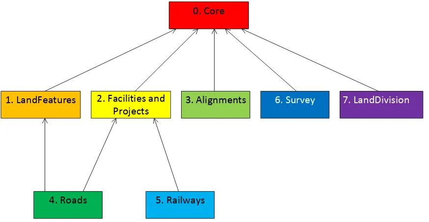
Figure 1. InfraGML Part Dependencies
The boxes above represent InfraGML Parts. Arrows show Part dependencies.
The Part dependencies derive from the dependencies of the InfraGML Requirements
Classes contained in these Parts. The reader should rely more on the InfraGML
Requirements Class dependencies and only use the Part dependencies as a guide for
knowing which InfraGML Part standards to consider.
LandInfra
0
Facility
2
Survey
6
LandDivision
7
Condominium
7
Project
2
Equipment
6
SurveyResults
6
Observations
6
Alignment
3
Road
4
RoadCrossSection
4
Railway
5
LandFeature
1
Sampling
6
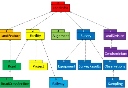
Figure 2. LandInfra Requirements Classes grouped into InfraGML Parts
The boxes above and their names represent LandInfra Requirements Classes. The
numbers are InfraGML Part numbers. Dependency arrows shown above are
dependencies between LandInfra Requirements Classes.
7.
Requirements Classes for this Part
7.1
Structural Overview of Requirements Classes
The Requirements Classes for this Part of the InfraGML encoding standard (shown in
blue in
Figure 3
below) are defined in this Clause 7. Requirements Classes from other
Parts upon which this Part’s Requirements Classes are dependent (shown in beige in
Figure 3
below) are listed here but defined in the documentation of their respective Parts.
External OGC and ISO standards on which Requirements Classes in this Standard depend
(shown in pink in
Figure 3
below) are also listed. Below is a brief summary of the
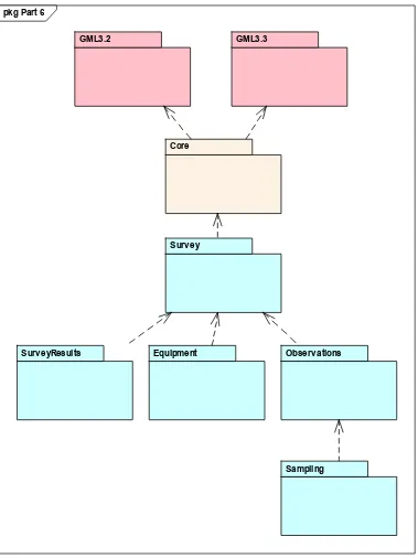
Figure 3. Requirements Classes for this Part and their Dependencies
In the OGC 15-111r1UML model the Survey LandInfra Requirement Classes had the
dependeny to OGC 07-022r1, OGC® Observations and Measurements — Part 1 —
Observation schema and OGC 07-002r3, OGC® Observations and Measurements — Part
2 — Sampling Features. However in GML 3.2 there is already an observation encoding
with the schema observation (
urn:x-ogc:specification:gml:schema-xsd:observation:3.2.1) defined. Therefore it was decided to use the GML observation for
the encoding of the InfraGML Requirement Classes in this part. Details on the
pkg Part 6
GML3.3 GML3.2
Core
Surv ey
Surv eyResults Equipment Observ ations
differences and the resulting differences to the OGC 11-111r1 UML model are listed in
section
Error! Reference source not found.
.
7.1.1
Requirement Classes Defined in This Part
Survey
The Survey Requirement Class supports those use cases to hold the observations,
processes and their results for the acquisition of points, lines, surfaces and properties of
features of interest. The primary focus of this package is to have the possibility of
recording and reprocessing the observations of the acquired objects.
The present Survey Requirement Class contains header information for the surveys, as
the survey package has been divided in sub- packages because of the number of classes in
the Observations, SurveyResults and Equipment packages.
Equipment
The Equipment Requirements Class describes the equipment, sensors, and observation
processes. The purpose of a Survey Process is to generate a survey result, and it holds all
the information about the sensors used for the measurements.
Observations
The Observations Requirements Class contains all measurements in a structured way to
enable later reprocessing.
Survey Results
The SurveyResults Requirement Class contains the estimate of the value(s) of a geometry
or property of the feature of interest.
Sampling
The Sampling Requirement Class dercribes the observational strategy and contains the
observation protocol including the related observation, the observation process and their
results.
Part 0. LandInfra Core
7.1.2
Other Standards upon which the Requirement Classes of this Part Depend
For external OGC and ISO standards on which Requirements Classes in this Standard
depend, a brief summary of the function of each of these Standards is described below.
GML 3.2
OGC 07-036, OpenGIS® Geography Markup Language (GML) Encoding Standard, v3.2
provides most of the geometry types (e.g., Point, LineString, Polygon) used for spatial
representations in this Standard. Defines Coordinate Reference Systems. Supports the
General Feature Model upon which this Standard is based.
GML 3.3
OGC 10-129r1, OGC® Geography Markup Language (GML) — Extended schemas and
encoding rules, v3.3 defines the linear referencing concepts (e.g., linear element, distance
along, Linear Referencing Methods) used for linearly referenced locations in this
Standard.
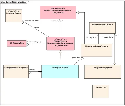
Figure 4. SurveyObservation and OGC Abstract Specification Topic20
Similar to the OM_Observation the observation class of GML 3.2 has an assoiciation to a
procedure (using), and association to a feature of interest (target) and an association to
the result of the observation (resultOf).
class Surv eyObserv ationClass
Equipment::Surv eyProcess
Surv eyObserv ation
«FeatureType»
OGC-ASTopic20- Observ ationsAndMeasurements::
OM_Observ ation GF_PropertyType
Surv eyResults::Surv eyResult
Equipment::Surv eySensor OGC-ASTopic20-
Observ ationsAndMeasurements:: OM_Process
Equipment::Equipment
«FeatureType»
LandInfra::Feature
LandInfra::ID
+surveySensor 0..*
+procedure 1
+surveySensor 1..* +procedure 1
+observedProperty
1
Domain +featureOfInterest 1
+result
Figure 5. GML 3.2.1 Observation
For the realization of Sampling a new requirement class for introduced in InfraGML to
also be able to support the sampling functionality defined in OGC® Observations and
Measurements — Part 2 — Sampling Features.
Using this model now allows us to remove the dependencies between Equipment,
Observations and SurveyResults. Therefore an application can choose if they just want to
support one of these Requirement Classes ( for example the application is just interested
in the SurveyResults, or another application just wants to reprocess the results internally).
However to cover the observation procedure Oberservations, Equipment and
SurveyResults ave to be supported by the application.
7.2
Requirements Class: Survey
Requirements Class
/req/survey
Target type
Conforming application
Name
Survey
Dependency
/req/core
(from InfraGML Part 0)
Requirement
/req/survey/elements
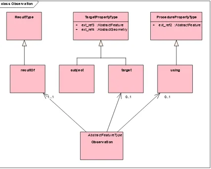
class Observ ation
AbstractFeatureType
Observ ation
using ProcedurePropertyType
+ ext_ref2 :AbstractFeature
target subj ect
TargetPropertyType
+ ext_ref3 :AbstractFeature + ext_ref4 :AbstractGeometry
resultOf ResultType
7.2.1
Implementation decisions regarding OGC 15-111r1 UML
The following implementation decisions have been made regarding the OGC 15-111r1
LandInfra Requirements Class UML:
1.
New association for surveyProcess has been added because of the change to have this
class as individual class with the link to SurveySensors instead of deriving
SurveySensors from gml:: ProcedurePropertyType – therefore SurveyProcess would
not have a home inside Equipment.
2.
New association for sampling has been added - Sampling would not have a home
inside Survey.
7.2.2
Specific Requirements for this Requirements Class
Requirement
/req/survey/elements
A conforming application shall support the Survey XML elements listed
in
Table 1
in accordance with the GML XSD specified in
http://schemas.opengis.net/infragml/part6/1.0/survey.xsd.
An application conforming to this standard shall support the Survey
XML elements listed
below in
Table 1
in accordance with the GML XSD specified in
http://schemas.opengis.net/infragml/part6/1.0/Survey.xsd. Survey
XML element names
are shown with a XML namespace prefix of “lis”. Corresponding LandInfra UML
classes are shown with their LandInfra Requirements Class prefix of “Survey”.
InfraGML XML element
LandInfra UML Class
lis:Survey
Survey::Survey
Table 1. InfraGML Survey XML elements with corresponding LandInfra UML classes
7.3
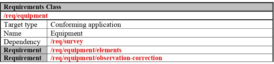
Requirements Class: Equipment
Requirements Class
/req/equipment
Target type
Conforming application
Name
Equipment
Dependency
/req/survey
Requirement
/req/equipment/elements
Requirement
/req/equipment/observation-correction
7.3.1
Implementation decisions regarding OGC 15-111r1 UML
(urn:x-ogc:specification:gml:schema-xsd:observation:3.2.1). InfraGML uses the GML
3.2 schema as the foundation for the LandInfra equipment schema. The O&M and
GML encodings are similar, only differing in association names and cardinalities.
This decision avoids depending on another external encoding.
2.
LandInfra SurveyProcess is derived from OM_Process, which is a Feature Type,
and most of the classes in the Equipment requirement class are derived from it.
Change #1 above means that Antenna has to be made a Feature Type
3.
Correction::type was set to optional- The type is then not needed for dervived
classes and makes the resulting xml file clener.
4.
Equipment : equivalent to #2
5.
SurveyProcess is derive from gml:ProcedurePropertyType instead of OM_Process
6.
SurveySensor - equivalent to #2.
7.
SurveySensor:attribute type set to optional because it is then not needed for
dervived classes.
8.
In the SurveySensorTpye enumeration a new type “other” was added and the
unused “tilt” entry was removed.
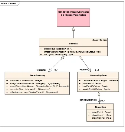
Figure 6. Camera Class encoding for ISO-19130
7.3.2
Specific Requirements for this Requirements Class
Requirement
/req/equipment/elements
A conforming application shall support the Survey XML elements listed
in
Table 2
in accordance with the GML XSD specified in
http://schemas.opengis.net/infragml/part6/1.0/equipment.xsd. An
application shall decide which SurveySensor types it will support and
then include appropriate elements accordingly.
class Camera
SurveySensor
Camera
+ autoFocus :Boolean [0..1]
+ offsetAndOrientation :gml::MovingObjectStatusType + crs :gml:CRSPropertyType
DetectorArray
+ numberOfDimentions :Integer
+ arrayDimentionsValue :Interger [1..2] {ordered} + arrayDimentionsName :CharacterString [1..2] {ordered} + detectorSize :Interger [1..2] {ordered}
+ offsetVector :gml:VectorType [1..2] {ordered}
SensorSystem
+ calibratedFocalLength :Distance + princPoint :Point
+ instFieldOfView :Angle + swathFieldOfView :Angle
Distortion
+ princPoint :Point + distortionK1 :Real + distortionK2 :Real
ISO-19130-ImagerySensors:: SD_SensorParameters
+opticalDistortion 0..1
+system 0..1
An application conforming to this standard shall support the Equipment
XML elements
listed below in
Table 2
in accordance with the GML XSD specified in
http://schemas.opengis.net/infragml/part6/1.0/Equipment.xsd. Equipment XML element
names are shown with a XML namespace prefix of “lise”. Corresponding LandInfra
UML classes are shown with their LandInfra Requirements Class prefix of “Equipment”.
InfraGML XML element
LandInfra UML Class
lise:AngularCorrection
Equipment::AngularCorrection
lise:Antenna
Equipment::Antenna
lise:Camera
Equipment::Camera
lise:Correction
Equipment::Correction
lise:DetectionArray
ISO-19130-SD_DetectionArray
lise:DistanceCorrection
Equipment::DistanceCorrection
lise:Distortion
ISO-19130-SD_Distortion
lise:EDM
Equipment::EDM
lise:Equipment
Equipment::Equipment
lise:GNSS
Equipment::GNSS
lise:GenericAngle
Equipment::GenericAngle
lise:GenericDistance
Equipment::GenericDistance
lise:InteriorOrientation
Equipment::InteriorOrientation
lise:LaserScanner
Equipment::LaserScanner
lise:Level
Equipment::Level
lise:ObservationCorrections
Equipment::ObservationCorrections
lise:Offset
Equipment::Offset
lise:SensorSystem
ISO-19130-SD_SensorSystem
lise:SurveyProcess
Equipment::SurveyProcess
lise:SurveySensor
Equipment::SurveySensor
lise:Tps
Equipment::Tps
lise:Transformation
Equipment::Transformation
Table 2. InfraGML Equipmnent XML elements with corresponding LandInfra UML classes
Requirement
/req/equipment/observation-correction
then that application shall support the ObservationCorrections element.
The application shall specify which correction types it supports.
7.4
Requirements Class: Observations
Requirements Class
/req/observations
Target type
Conforming application
Name
Observations
Dependency
/req/survey
Requirement
/req/observations/elements
7.4.1
Implementation decisions regarding OGC 15-111r1 UML
The implementation follows the OGC 15-111r1Survey Requirements Class UML.
1.
In OGC 15-111r1 the observations requirement class depends on OGC 07-022r1,
OGC® Observations and Measurements — Part 1 — Observation schema and
OGC 07-002r3, OGC® Observations and Measurements — Part 2 — Sampling
Features. However GML 3.2 already defines an observation encoding
(urn:x-ogc:specification:gml:schema-xsd:observation:3.2.1). InfraGML uses the GML
3.2 schema as the foundation for the LandInfra equipment schema. The O&M and
GML encodings are similar, only differing in association names and cardinalities.
This decision avoids depending on another external encoding.
2.
LandInfra SurveyObject is derived from OM_Observation, which is a Feature
Type, and most of the classes in the Survey requirement class are derived from it.
Change #1 above means that PanoramaImage and Setup have to be made Feature
types.
3.
ImageObservations and PanoramaImage has been added as optional attributes to
SurveyObservation. All observation classes derived from SurveyObservation can
now include references to images (example: PointCloudObservation has a link to
an image to colorize the pointcloud).
7.4.2
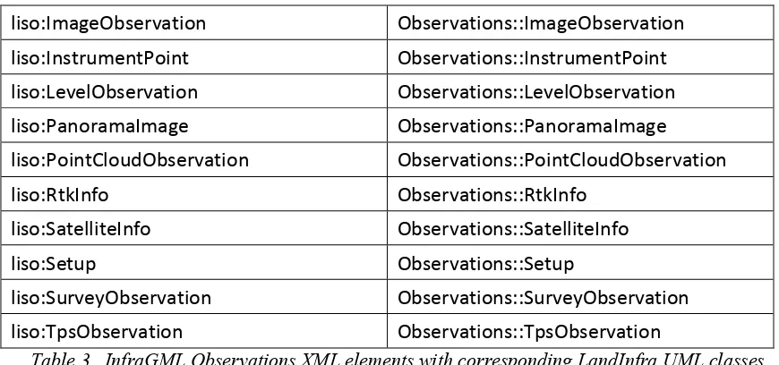
Specific Requirements for this Requirements Class
Requirement
/req/observations/elements
A conforming application shall support the Survey XML elements listed
in
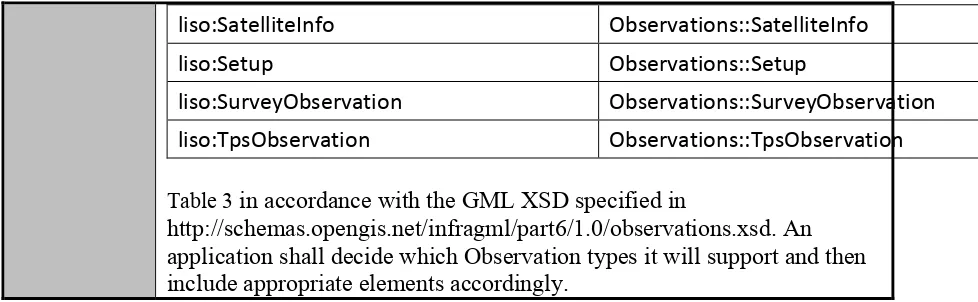
liso:InstrumentPoint
Observations::InstrumentPoint
liso:LevelObservation
Observations::LevelObservatio
liso:PanoramaImage
Observations::PanoramaImage
liso:PointCloudObservation
Observations::PointCloudObse
liso:SatelliteInfo
Observations::SatelliteInfo
liso:Setup
Observations::Setup
liso:SurveyObservation
Observations::SurveyObservation
liso:TpsObservation
Observations::TpsObservation
Table 3
in accordance with the GML XSD specified in
http://schemas.opengis.net/infragml/part6/1.0/observations.xsd. An
application shall decide which Observation types it will support and then
include appropriate elements accordingly.
An application conforming to this standard shall support the Observations XML elements
listed below in
liso:InstrumentPoint
Observations::InstrumentPoint
liso:LevelObservation
Observations::LevelObservation
liso:PanoramaImage
Observations::PanoramaImage
liso:PointCloudObservation
Observations::PointCloudObservation
liso:RtkInfo
Observations::RtkInfo
liso:SatelliteInfo
Observations::SatelliteInfo
liso:Setup
Observations::Setup
liso:SurveyObservation
Observations::SurveyObservation
liso:TpsObservation
Observations::TpsObservation
Table 3
in accordance with the GML XSD specified in
http://schemas.opengis.net/infragml/part6/1.0/Observations.xsd. Observations XML
element names are shown with a XML namespace prefix of “liso”. Corresponding
LandInfra UML classes are shown with their LandInfra Requirements Class prefix of
“Observations”.
InfraGML XML element
LandInfra UML Class
liso:AngularObservation
Observations::AngularObservation
liso:DistanceObservation
Observations::DistanceObservation
liso:ExteriorOrientation
Observations::ExteriorOrientation
liso:GF_PropertyType
Observations::GF_PropertyType
liso:GnssObservation
Observations::GnssObservation
liso:ImageObservation
Observations::ImageObservation
liso:InstrumentPoint
Observations::InstrumentPoint
liso:LevelObservation
Observations::LevelObservation
liso:PanoramaImage
Observations::PanoramaImage
liso:PointCloudObservation
Observations::PointCloudObservation
liso:RtkInfo
Observations::RtkInfo
liso:SatelliteInfo
Observations::SatelliteInfo
liso:Setup
Observations::Setup
liso:SurveyObservation
Observations::SurveyObservation
liso:TpsObservation
Observations::TpsObservation
Table 3. InfraGML Observations XML elements with corresponding LandInfra UML classes
7.5
Requirements Class: SurveyResults
Requirements Class
/req/survey-results
Target type
Conforming application
Name
SurveyResults
Dependency
/req/survey
Requirement
/req/survey-results/elements
7.5.1
Implementation decisions regarding OGC 15-111r1 UML
The implementation follows the OGC 15-111r1Survey Requirements Class UML.
1.
In OGC 15-111r1 the observations requirement class depends on OGC 07-022r1,
OGC® Observations and Measurements — Part 1 — Observation schema and
OGC 07-002r3, OGC® Observations and Measurements — Part 2 — Sampling
Features. However GML 3.2 already defines an observation encoding
(urn:x-ogc:specification:gml:schema-xsd:observation:3.2.1). InfraGML uses the GML
3.2 schema as the foundation for the LandInfra equipment schema. The O&M and
GML encodings are similar, only differing in association names and cardinalities.
This decision avoids depending on another external encoding.
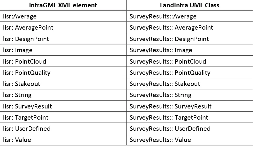
7.5.2
Specific Requirements for this Requirements Class
Requirement
/req/survey-results/elements
A conforming application shall support the Survey XML elements listed
in
lisr: Value
SurveyResults:: Value
Table 4
in accordance with the GML XSD specified in
http://schemas.opengis.net/infragml/part6/1.0/surveyResults.xsd. An
application shall decide which SurveyResults types it will support and
then include appropriate elements accordingly.
An application conforming to this standard shall support the SurveyResults XML
elements listed below in
lisr: UserDefined
SurveyResults:: UserDefined
lisr: Value
SurveyResults:: Value
Table 4
in accordance with the GML XSD specified in
http://schemas.opengis.net/infragml/part6/1.0/ SurveyResults.xsd. SurveyResults XML
element names are shown with a XML namespace prefix of “lisr”. Corresponding
LandInfra UML classes are shown with their LandInfra Requirements Class prefix of
“SurveyResults”.
InfraGML XML element
LandInfra UML Class
lisr:Average
SurveyResults::Average
lisr: AveragePoint
SurveyResults:: AveragePoint
lisr: DesignPoint
SurveyResults:: DesignPoint
lisr: Image
SurveyResults:: Image
lisr: PointCloud
SurveyResults:: PointCloud
lisr: PointQuality
SurveyResults:: PointQuality
lisr: Stakeout
SurveyResults:: Stakeout
lisr: String
SurveyResults:: String
lisr: SurveyResult
SurveyResults:: SurveyResult
lisr: TargetPoint
SurveyResults:: TargetPoint
lisr: UserDefined
SurveyResults:: UserDefined
lisr: Value
SurveyResults:: Value
Table 4. InfraGML SurveyResults XML elements with corresponding LandInfra UML classes
7.6
Requirements Class: Sampling
Requirements Class
/req/sampling
Name
Sampling
Dependency
/req/observations
Requirement
/req/sampling/elements
7.6.1
Implementation decisions regarding OGC 15-111r1 UML
The implementation follows the OGC 15-111r1Survey Requirements Class UML.
1.
Sampling Features is defined in OGC® Observations and Measurements — Part 2
— Sampling Features. The decision to use the observation encoding
(urn:x-ogc:specification:gml:schema-xsd:observation:3.2.1) of GML it is necessary to
add this Requirement Class to also support Sampling.
7.6.2
Specific Requirements for this Requirements Class
Requirement
/req/sampling/elements
A conforming application shall support the Survey XML elements listed
in
Table 5
in accordance with the GML XSD specified in
http://schemas.opengis.net/infragml/part6/1.0/sampling.xsd.
An application conforming to this standard shall support the Sampling XML elements
listed below in
Table 5
in accordance with the GML XSD specified in
Figure 7. OGC Abstract Specification Topic 20 – Sampling Feature
InfraGML XML element
LandInfra UML Class
liss: SamplingFeature
sam: SF_SamplingFeature
liss: SamplingFeatureComplex
sam: SamplingFeatureComplex
liss: SamplingFeatureCollection
sam: SF_SamplingFeatureCollection
Table 5. InfraGML Sampling XML elements with corresponding LandInfra UML classes
8.
Media Types for any data encoding(s)
Data for all Parts of the InfraGML encoding standard is encoded in GML-conformant
XML documents. The standard MIME-type and sub-type for GML data should be used to
indicate the encoding in internet exchange, as specified in MIME Media Types for GML,
namely ‘application/gml+xml’.
class SamplingFeature
«FeatureType»
SF_SamplingFeature
«FeatureType»
OM_Observ ation
«FeatureType»
SF_SamplingFeatureCollection
{} «FeatureType»
LandInfra::Feature
SamplingFeatureComplex
0..* +relatedSamplingFeature 0..* Intention
+sampleFeature 1..*
Design
+relatedObservation 0..*
Annex A:
Conformance Class Abstract Test Suite (Normative)
A.1
Conformance class: Survey
/conf/survey
Requirements
/req/surveyDependency
/conf/core(from InfraGML Part 0)
Test /conf/survey/elements
Requirement
/req/survey/elementsTest purpose Verify that the conforming application supports the
Survey XML elements listed in Table 1 in accordance
with the GML XSD specified in
http://schemas.opengis.net/infragml/part6/1.0/survey.xsd.
Test method Inspect the GML output to verify the above
requirement.
Test type
Capability
A.2
Conformance class: Equipment
/conf/equipment
Requirements
/req/equipmentDependency
/conf/surveyTest /conf/equipment/elements
Requirement
/req/equipment/elementsTest purpose Verify that the conforming application supports the
Equipment XML elements listed in Table 2 in accordance
with the GML XSD specified in
http://schemas.opengis.net/infragml/part6/1.0/equipment.x
sd.
Test method Inspect the GML output to verify the above
requirement.
Test type
Capability
Test /conf/equipment/
observation-correction
Requirement
/req/equipment/elementsTest purpose Verify that the conforming application specifies which
correction types it supports, if any.
Test method Inspect the GML output to verify the above
requirement.
Test type
Capability
A.3
Conformance class: Observations
/conf/observations
Requirements
/req/observationsDependency
/conf/surveyRequirement
/req/observations/elementsTest purpose Verify that the conforming application supports the
Observations XML elements listed in Table 3 in
accordance with the GML XSD specified in
http://schemas.opengis.net/infragml/part6/1.0/observation
s.xsd.
Test method Inspect the GML output to verify the above
requirement.
Test type
Capability
A.4
Conformance class:SurveyResults
/conf/survey-results
Requirements
/req/survey-resultsDependency
/conf/surveyTest /conf/survey-results/elements
Requirement
/req/survey-results/elementsTest purpose Verify that the conforming application supports the
SurveyResults XML elements listed in Table 4 in
accordance with the GML XSD specified in
http://schemas.opengis.net/infragml/part6/1.0/surveyResul
ts.xsd.
Test method Inspect the GML output to verify the above
requirement.
Test type
Capability
A.5
Conformance class:Sampling
/conf/sampling
Requirements
/req/samplingDependency
/conf/observations Test /conf/sampling/elementsRequirement
/req/sampling/elementsTest purpose Verify that the conforming application supports the
Sampling XML elements listed in Table 5 in accordance
with the GML XSD specified in
http://schemas.opengis.net/infragml/part6/1.0/sampling.xs
d.
Test method Inspect the GML output to verify the above
requirement.
Annex B:
Sample XML (Informative)
<description>LandInfra dataset to test all possible content for Part6 Survey</description>
<dateTime>2016-10-19T10:00:00</dateTime>
<datasetVersion>1.0</datasetVersion>
<application>manual</application>
<author>Hans-Christoph Gruler, Leica Geosystems AG</author>
<infraVersion>1.0</infraVersion>
<language>English</language>
<defaultCRS xlink:href="crs1"/> <abstractData>
<lis:Survey gml:id="S1">
<gml:description>sample survey definition required content</gml:description> <lis:surveyID>
</property> </PropertySet> </propertySet> <lis:surveyID> <lis:ID>
<identifier>Survey2</identifier> <scope>OGC LandInfraSWG</scope> </lis:ID>
</lis:surveyID> <lis:landSurveyor>
<Professional gml:id="p1">
<li:fullName>Surveyor1</li:fullName>
<li:type xlink:href="http://example.com/professionalType#landSurveyor" xlink:title="Land Surveyor"/>
<li:company>LandSurveyors Inc.</li:company> <li:registration>SR12345678</li:registration>
<li:licensingCountry>Switzerland</li:licensingCountry> </Professional>
</lis:landSurveyor>
<lis:purposeOfSurvey>Determination of new Parcel Boundery</lis:purposeOfSurvey> <lis:type xlink:href="http://example.com/surveyType#surveyed" xlink:title="Surveyed"/> <lis:document>
<Document gml:id="D1"> <documentID>
<ID>
<identifier>20160004</identifier> </ID>
</documentID>
<documentType>Survey Marking</documentType>
<documentContent>http://city.net/survey/documents.pdf</documentContent> </Document>
</lis:document> </lis:Survey>
B. 2
Equipment
<description>LandInfra dataset to test all possible content for Part6 Survey Equipment
</description>
<dateTime>2016-10-19T10:00:00</dateTime>
<datasetVersion>1.0</datasetVersion>
<application>manual</application>
<author>Hans-Christoph Gruler, Leica Geosystems AG</author>
<infraVersion>1.0</infraVersion>
</lise:Equipment>
<gml:description>sample survey definition all possible content</gml:description> <gml:name>Survey 1 Survey</gml:name>
<li:type xlink:href="http://example.com/professionalType#landSurveyor" xlink:title="Land Surveyor"/>
<li:company>LandSurveyors Inc.</li:company> <li:registration>SR12345678</li:registration>
<li:licensingCountry>Switzerland</li:licensingCountry> </Professional>
</lis:landSurveyor>
<lis:purposeOfSurvey>Determination of new Parcel Boundery</lis:purposeOfSurvey> <lis:type xlink:href="http://example.com/surveyType#surveyed" xlink:title="Surveyed"/> <lis:equipment>
<lise:Equipment gml:id="E2">
<gml:description>sample survey equipment definition all possible sensors</gml:description>
<gml:name>Equipment 12 Crew2</gml:name> <lise:serialID>12345678</lise:serialID>
<lise:dataCollector>Survey Datacollector</lise:dataCollector> <lise:controlSoftware>Software for Surveyors</lise:controlSoftware> <lise:softwareVersion>1.97 Build 34</lise:softwareVersion>
<identifier>Scanner2</identifier>
<lise:compLongitudinal uom="deg">0.000030814891377</lise:compLongitudinal> <lise:compTransversal uom="deg">-0.000485202964925</lise:compTransversal> <lise:camera>
<lise:crossHairPosY uom="Pixel">0</lise:crossHairPosY>
<lis:SurveyProcess xsi:type="lise:SurveyProcessType"> <lise:surveyProcessID>
<lise:ID>
<identifier>SP1</identifier> </lise:ID>
</lise:surveyProcessID>
<lise:surveySensor xlink:href="SGA1"></lise:surveySensor> <lise:surveySensor xlink:href="SS2"></lise:surveySensor> </lis:SurveyProcess>
</lis:surveyProcess> <lis:surveyProcess>
<lise:surveyProcessID>
<lise:type xlink:href="http://example.com/observationCorrectionType#userDefined" xlink:title="User Defined"/>
<lis:SurveyProcess xsi:type="lise:ObservationCorrectionsType"> <lise:surveyProcessID>
<lise:projectionDistortion uom="m">0.9996</lise:projectionDistortion> <lise:individualScale uom="m">1.0006</lise:individualScale>
<lise:crossOffset uom="m">1.123</lise:crossOffset>
<lis:SurveyProcess xsi:type="lise:ObservationCorrectionsType"> <lise:surveyProcessID>
B. 3
Equipment and SurveyProcess
<description>LandInfra dataset to test all possible content for Part6 Survey Equipment
</description>
<dateTime>2016-10-19T10:00:00</dateTime>
<datasetVersion>1.0</datasetVersion>
<application>manual</application>
<author>Hans-Christoph Gruler, Leica Geosystems AG</author>
<infraVersion>1.0</infraVersion>
</lise:Equipment>
<gml:description>sample survey definition all possible content</gml:description> <gml:name>Survey 1 Survey</gml:name>
<li:type xlink:href="http://example.com/professionalType#landSurveyor" xlink:title="Land Surveyor"/>
<li:company>LandSurveyors Inc.</li:company> <li:registration>SR12345678</li:registration>
<li:licensingCountry>Switzerland</li:licensingCountry> </Professional>
</lis:landSurveyor>
<lis:purposeOfSurvey>Determination of new Parcel Boundery</lis:purposeOfSurvey> <lis:type xlink:href="http://example.com/surveyType#surveyed" xlink:title="Surveyed"/> <lis:equipment>
<lise:Equipment gml:id="E2">
<gml:description>sample survey equipment definition all possible sensors</gml:description>
<gml:name>Equipment 12 Crew2</gml:name> <lise:serialID>12345678</lise:serialID>
<lise:dataCollector>Survey Datacollector</lise:dataCollector> <lise:controlSoftware>Software for Surveyors</lise:controlSoftware> <lise:softwareVersion>1.97 Build 34</lise:softwareVersion>
</lise:surveySensorID>
<lise:compLongitudinal uom="deg">0.000030814891377</lise:compLongitudinal> <lise:compTransversal uom="deg">-0.000485202964925</lise:compTransversal> </lise:Tps>
</lise:surveySensor> </lise:Equipment> </lis:equipment> <lis:surveyProcess>
<lis:SurveyProcess xsi:type="lise:SurveyProcessType"> <lise:surveyProcessID>
<lis:SurveyProcess xsi:type="lise:ObservationCorrectionsType"> <lise:surveyProcessID>
<lise:ID>
</lise:ID>
<lise:type xlink:href="http://example.com/observationCorrectionType#userDefined" xlink:title="User Defined"/>
<lis:SurveyProcess xsi:type="lise:ObservationCorrectionsType"> <lise:surveyProcessID>
</lis:SurveyProcess> </lis:surveyProcess> <lis:surveyProcess>
<lis:SurveyProcess xsi:type="lise:ObservationCorrectionsType"> <lise:surveyProcessID>
B. 4
Observations
<description>LandInfra dataset to test all possible content for Part6 Observations</description>
<dateTime>2016-12-02T10:00:00</dateTime>
<datasetVersion>1.0</datasetVersion>
<application>manual</application>
<author>Paul Scarponcini, Bentley Systems, Inc.</author>
<infraVersion>1.0</infraVersion>
<language>English</language>
<defaultCRS xlink:href="crs1"/>
<featureAssociation>
<FeatureAssociation gml:id="fa1">
<gml:description>associates document 20160004 with Survey Mark
1001</gml:description>
<gml:name>survey marking</gml:name> <fromFeature xlink:href="d1"/>
<fromRole>documentation for</fromRole> <toFeature xlink:href="sm1"></toFeature> <toRole>documented survey mark</toRole>
<documentType>Survey Marking</documentType>
</lis:surveyID> <lis:setup>
<liso:Setup gml:id="SET1">
<gml:description>sample survey observation definition required content all possible observations</gml:description>
<gml:beginPosition>2016-08-24T09:01:00</gml:beginPosition>
<gml:description>sample survey observation definition all possible content of observations</gml:description>
<gml:name>Setup 2</gml:name>
<liso:instrumentHeight uom="m">1.50</liso:instrumentHeight> <liso:instrumentPoint>
<liso:InstrumentPoint gml:id="S2IP1"> <gml:location>
</gml:Point>
</gml:TimePeriod> </gml:validTime> <gml:resultOf> <gml:File>
<gml:rangeParameters>
<gml:name>PointCloud02</gml:name> </gml:rangeParameters>
<gml:fileName>PointCloud2345.las</gml:fileName> <gml:fileStructure>ASCII</gml:fileStructure> </gml:File>
</gml:resultOf> <liso:resultTime>
<gml:TimeInstant gml:id="PO2RT1">
<gml:timePosition>2016-08-24T09:05:04</gml:timePosition> </gml:TimeInstant>
</liso:resultTime>
<liso:bInstrumentPoint>true</liso:bInstrumentPoint> <liso:image xlink:href="IO1"></liso:image>
<liso:image xlink:href="IO2"></liso:image>
<liso:panoImage xlink:href="POI1"></liso:panoImage> <liso:numberPoints>20000000000</liso:numberPoints> <liso:maxSNR>3177</liso:maxSNR>
<liso:minSNR>29</liso:minSNR>
<liso:maxIntensity>52771</liso:maxIntensity> <liso:minIntensity>978</liso:minIntensity>
<liso:maxDistance uom="m">3.693400</liso:maxDistance> <liso:minDistance uom="m">3.164200</liso:minDistance> <liso:maxNorthing uom="m">0.350678</liso:maxNorthing> <liso:minNorthing uom="m">-0.090125</liso:minNorthing> <liso:maxEasting uom="m">0.416469</liso:maxEasting> <liso:minEasting uom="m">-0.241113</liso:minEasting> <liso:maxElevation uom="m">0.001460</liso:maxElevation> <liso:minElevation uom="m">-0.460276</liso:minElevation> </liso:PointCloudObservation>
</liso:surveyObservation> </liso:Observations> </liso:observations> <liso:panoImage>
<liso:PanoramaImage gml:id="POI1">
<liso:panoramaImageID>Panorama 1</liso:panoramaImageID> <liso:image xlink:href="IO1"></liso:image>
<liso:image xlink:href="IO2"></liso:image> </liso:PanoramaImage>
</liso:panoImage> </liso:Setup> </lis:setup> </lis:Survey>
B. 5
SurveyResults
<lis:purposeOfSurvey>String</lis:purposeOfSurvey>
<lis:type xlink:href="http://example.com/surveyType#surveyed" xlink:title="Surveyed"/> <lis:surveyResult>
<lisr:SurveyResult gml:id="SR1">
<gml:description>sample survey result definition all content of results</gml:description> <lisr:surveyResultID>
<lisr:ID>
<identifier>UserDefined</identifier> </lisr:ID>
</lisr:surveyResultID>
B. 6
Sampling
<identification>1001</identification> </SurveyMark>
<lis:purposeOfSurvey>String</lis:purposeOfSurvey>
<lis:type xlink:href="http://example.com/surveyType#surveyed" xlink:title="Surveyed"/> <lis:setup>
<liso:Setup gml:id="SET1">
<gml:description>sample survey observation definition required content all possible observations</gml:description>
<liso:instrumentHeight uom="m">1.50</liso:instrumentHeight> <liso:validTime>