Jame s E. Bruno Use o f ge o graphic al info rmatio n syste ms (GIS) mapping pro c e dure s to suppo rt e duc atio nal po lic y analysis and sc ho o l site manage me nt
Inte rnatio nal Jo urnal o f Educ atio nal Manage me nt 1 0 / 6 [1 9 9 6 ] 2 4 –3 1
r a t h er t h a n in ves t iga t in g t h e iss u e of ch oice by a ggr e ga t in g a ll t h e d a t a .
Ma s k in g im p or t a n t in for m a t ion t h a t r ela t es t o w h y cer t a in sch ools w er e ch osen over ot h er s ch ools is on e of t h e lim it a t ion s of s t u dy in g fa m ily ch oice u s in g a ggr e ga t e d a t a .
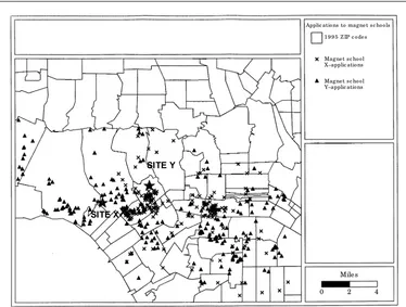
In r es ea r ch st u d ies of fa m ily ch oice, u su a lly a ll r esp on d en t s a r e s u r veyed for t h e va r iou s in for m a t ion fa ct or s (sa fet y, a t t a in m en t , p r o-gr a m m es, et c.) w h ich im p a ct on t h eir d eci-sion t o a t t en d a cer t a in s ch ool sit e in a la r ge d is t r ict . T h e u s u a l s u r vey r es ea r ch t y p e of p r oced u r e t h u s t en d s la r gely t o over w h elm , in a s t a t is t ica l fa s h ion , t h e m os t im p or t a n t fa ct or s t h a t con st it u t e ch oice for p a r en t s w h o h ave s im ila r geogr a p h ica l d ist a n ces fr om ea ch ot h er yet ch ose d iffer en t sch ools [9,14,15]. T h e geogr a p h ica l m a p of a p p lica t ion s of st u d en t s t o m a gn et p r ogr a m m es ca n t h u s b ecom e a p ow er fu l m ech a n is m for v isu a l-izin g t h e im p a ct of cer t a in s ch ool ch oice, p olicies, a n d for eva lu a t in g t h e effect iven es s of va r iou s t y p es of in for m a t ion a b ou t t h e m a gn et s ch ools t o p a r en t s.
In t h is illu st r a t ion , t wo m a gn et s ch ool p r ogr a m m es, t en m iles a p a r t , w er e su b m it t ed t o a geogr a p h ica l m a p p in g a n a ly sis. T h e r esu lt s of t h is GIS m a p of s t u d en t a p p lica n t loca t ion a r e p r es en t ed in F igu r e 1. N ot e t h a t
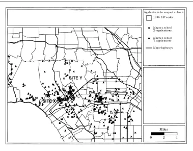
t h em a t ic layer s, su ch a s aver a ge h ou seh old in com e a n d p er cen t bla ck by geogr a p h ic r e gion on t h e m a p (zip cod e or cen su s t r a ck ), cou ld a lso over la id on t h e r e gion m a p. Ow in g t o t h e p r oh ib it ive cost of gen er a t in g a color m a p, on ly clien t (st u d en t a p p lica n t s) loca -t ion s a n d zip cod es a r e r e p r esen -t ed . N o-t e -t h e obv iou s clu st er in g of a p p lica t ion s by fa m ilies w h ich live in close p r oxim it y. F a r m or e in t er est in g for t h e fa m ily ch oice r esea r ch er, h ow -ever, a r e t h ose a p p lica t ion s w h ich a r e fou n d in close p r oxim it y t o ea ch ot h er, yet w h o ch ose d iffer en t sch ools (see F igu r e 2). Also n ot e h ow a m a n -m a d e geogr a p h ica l b a r r ier, su ch a s a m a jor h igh w ay or fr eew ay, a lso seem s t o im p a ct on t h e s ch ool ch oice d ecision (see F igu r e 2). N ot e h ow t h e h igh w ay seem s t o d iv id e t h ose w h o d esir e t o go t o on e s ch ool fr om t h ose w h o d esir e t o go t o t h e ot h er sch ool.
In s u m m a r y, t h os e ed u ca t ion a l r es ea r ch er s a n d p olicy a n a ly st s in t er est ed in sch ool-fa m ily iss u es ch oice wou ld fi n d t h is t y p e of geogr a p h ica l in for m a t ion ext r em ely u sefu l for exa m in in g t h e im p a ct of geogr a p h ica l d ist a n ce on ch oice a n d fi n d in g “ch oice” p a ir s of a p p lica n t s w h o cou ld by su r veyed in m or e d e p t h in or d er t o p r ov id e a b et t er u n d er -st a n d in g of t h e r ole of in for m a t ion in t h e fi n a l ch oice select ion of a m a gn et sch ool sit e.
Applic atio ns to magne t s c ho o ls 1 9 9 5 Z IP c o de s
Mile s
0 2 4
SITE Y
SITE X
Magne t s c ho o l X–applic atio ns Magne t s c ho o l Y–applic atio ns
Figure 1
Jame s E. Bruno Use o f ge o graphic al info rmatio n syste ms (GIS) mapping pro c e dure s to suppo rt e duc atio nal po lic y analysis and sc ho o l site manage me nt
Inte rnatio nal Jo urnal o f Educ atio nal Manage me nt 1 0 / 6 [1 9 9 6 ] 2 4 –3 1
School outreach services to the
community and geographical
location
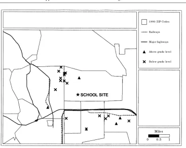
T h e secon d illu s t r a t ion of t h e GIS m a p p in g p r oced u r e en t a ils t h e sy st em a t ic p la n n in g of sch ool s it e ou t r ea ch ed u ca t ion a l p r ogr a m m es t o t h e com m u n it y. Sch ool sit e a d m in is t r a t or s wou ld b e p a r t icu la r ly in t er es t ed in t h ese t y p es of GIS a p p lica t ion s s in ce t h ey ca n b e u s ed t o loca t e st u d en t s w it h s p ecia l a ca d em ic n eed s. On ce t h es e p op u la t ion s a r e id en t ifi ed on a m a p, sch ool a d m in is t r a t or s m igh t b e b et t er a ble t o a d d r ess t h os e a ca d em ic n eed s w it h r em ot e, off-s it e in s t r u ct ion a l s u p p or t p r ogr a m m es a n d / or ot h er s ocia l s er v ice su p p or t p r ogr a m m es [16,17]. In t h is a p p lica -t ion , a geogr a p h ica l a n a ly sis w a s u sed -t o loca t e a ll s t u d en t s w h o w er e sign ifi ca n t ly a b ove a n d b elow gr a d e levels. Aga in , t h e m a p cou ld b e layer ed w it h d em ogr a p h ic in for m a -t ion , s u ch a s aver a ge h ou seh old in com e, a n d p er cen t m in or it y, a n d t h en colou r cod ed by r e gion (in t h is ca s e zip cod e).
N ote fr om F igu r e 3 th a t th er e wer e clu ster s of stu den ts in specifi c r e gion s of th e com -m u n ity wh er e -m a n y of th e below gr a de level stu den ts r esided. Most of th ese clu ster s of stu den ts wer e som e dista n ce fr om th e a ctu a l sch ool site, th er efor e, geogr a ph ica l dista n ce im peded th e a ttr a ctiven ess of offer in g
a fter -sch ool, on -site in str u ction a l su ppor t pr ogr a m m es. In stea d, a pr oject w a s developed wh ich m a de u se of a tr a iler -va n equ ipped w ith com pu ter wor k sta tion s, ta bles, a n d sta ffed w ith edu ca tion a l per son n el. Th e tr a iler -va n w a s th en br ou gh t to th e com m u n ity loca tion con ta in in g th e h igh est clu ster s of below gr a de level stu den ts. In sh or t, GIS pr ocedu r es wer e u sed to pr ovide edu ca tion a l a n d in str u ction a l su ppor t ser vices to stu den ts a t loca tion s wh ich wer e in close pr oxim ity to th eir a ddr ess, r a th er th a n pr ovidin g th ese ser vices a t th e sch ool site. N ote th a t in th is a pplica tion a geogr a ph ica l m a p is gen er a ted to deter m in e th e clu ster s of stu den ts (see F igu r e 4). Th e sa m e m a p ca n th en be u sed to deter m in e th e best loca tion for th e r em ote or off-site in str u c-tion a l su ppor t pr ogr a m m e. Geogr a ph ica l dista n ce, a s a fa ctor in u n der a ch ievem en t, ca n th en be pa r tia lly a ddr essed by th e geogr a ph i-ca l loi-ca tion of a ser vice veh icle for edu i-ca tion a l su ppor t ser vices in th e com m u n ity. In a sim i-la r a n d ea r lier a pplica tion of th e GIS m a ppin g pr ocedu r e for com m u n ity ou tr ea ch , m oth er s of low bir th weigh t ba bies a n d sin gle pa r en t h om es wer e m a tch ed to in ocu la tion ser vice cen tr es in th e Atla n ta , Geor gia a r ea [17]. Wh en u sin g GIS m a ppin g pr ocedu r es for th ese types of geogr a ph ica l “loca tion ” a pplica tion s, cer -ta in specifi c qu estion s m u st be a ddr essed. Th ese qu estion s in clu de:
Applic atio ns to magne t s c ho o ls 1 9 9 5 Z IP c o de s
Mile s
0 2 4
SITE Y
SITE X
Magne t s c ho o l X–applic atio ns Magne t s c ho o l Y–applic atio ns Majo r highways
Figure 2
Jame s E. Bruno Use o f ge o graphic al info rmatio n syste ms (GIS) mapping pro c e dure s to suppo rt e duc atio nal po lic y analysis and sc ho o l site manage me nt
Inte rnatio nal Jo urnal o f Educ atio nal Manage me nt 1 0 / 6 [1 9 9 6 ] 2 4 –3 1
Mile s
0 0 .5 1
SCHOOL SITE
1 9 9 5 Z IP Co de s Railways Majo r highways Abo ve grade le ve l Be lo w grade le ve l
Figure 3
Lo c atio n o f ins truc tio nal s uppo rt s e rvic e s fo r abo ve and be lo w grade le ve l s tude nts
Stude nt attainme nt 1 9 9 5 Z IP c o de s Railways Stre e ts Majo r highways Abo ve grade le ve l Be lo w grade le ve l
Mile s
0 0 .2 0 .4
SCHOOL SITE REM OTE OFF-SITE LOCATION Figure 4
Jame s E. Bruno Use o f ge o graphic al info rmatio n syste ms (GIS) mapping pro c e dure s to suppo rt e duc atio nal po lic y analysis and sc ho o l site manage me nt
Inte rnatio nal Jo urnal o f Educ atio nal Manage me nt 1 0 / 6 [1 9 9 6 ] 2 4 –3 1
• a n exa ct a s sess m en t of com m u n it y n eed s ; • r es ea r ch in t o t h e loca t ion of cu r r en t
com m u n it y r esou r ces t o ser v ice t h os e n eed s; a n d
• d evelop in g a s er v ice com p on en t t h a t lin k s t h e n eed s of t h e com m u n it y t o t h e
r es ou r ces ava ila ble.
All t h r ee of t h es e iss u es ca n b e a d d r es s ed u s in g GIS m a p p in g p r oced u r es.
New and continuing student
participation and geographical
distance
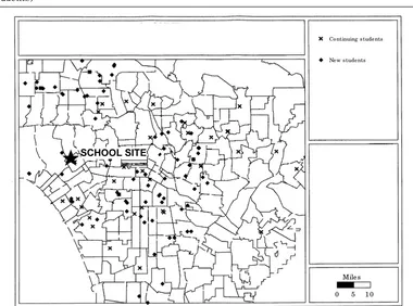
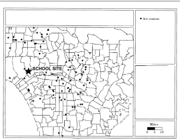
In t h e fi n a l illu st r a t ive a p p lica t ion of GIS m a p p in g, clien t s (n ew a n d con t in u in g st u d en t s ) of a la r ge ed u ca t ion a l cen t r e w er e id en t ifi ed in t er m s of t h eir geogr a p h ica l d is t a n ce. T h e p u r p ose h er e w a s n ot on ly t o exa m in e geogr a p h ica lly n ew a n d con t in u in g st u d en t loca t ion s a t t h e ed u ca t ion a l cen t r e, bu t t o p r ov id e s om e in s igh t s r e ga r d in g t h e d is t a n ces t r avelled . On ce n ew a n d con t in u in g st u d en t loca t ion s w er e d et er m in ed , q u es t ion s su ch a s w h er e t o p la ce a s a t ellit e ca m p u s, h ow b es t t o est a blish ca r p ools, w h er e t o p la ce a lu m n i cen t r es a n d fu n ct ion s, w h er e t o p la ce r ecr u it m en t , cen t r es et c., cou ld b e a d d r es s ed .
F igu r e 5 d isp lay s a ll n ew s t u d en t s en r olled in t h e ed u ca t ion a l p r ogr a m m e. Over la id on
t h e m a p ca n a lso b e com m u n it y r esou r ces, su ch a s lib r a r ies a n d ot h er ed u ca t ion a l fa cilit ies, so t h a t m or e effect ive co-or d in a t ion of socia l ser v ices cou ld b e a t t a in ed .
F igu r e 6 s h ow s b ot h n ew a n d con t in u in g st u d en t s in t h e p r ogr a m m e. H er e, p ossible p a ir in gs of st u d en t s by geogr a p h ica l d ist a n ce ca n b e a ch ieved . P a ir in g of n ew a n d con t in u in g st u d en t s for p u r p os es of ca r p oolin g, sem -in a r s, et c. ca n a lso b e a ch ieved w it h t h is t y p e of m a p.
F in a lly, if com m u n it y r e p r esen t a t ion a t t h e ed u ca t ion cen t r e is a goa l of t h e com m u n it y, t h en t h em a t ic in for m a t ion , s u ch a s fa m ily in com e, p er cen t bla ck , et c., in ea ch r e gion of t h e m a p (zip cod e) cou ld b e over la id on t h e m a p.
Extensions of GIS
T h ese t h r ee illu s t r a t ive a p p lica t ion s of t h e GIS m a p p in g p r oced u r e n icely d em on st r a t e t h a t t h e v isu a liza t ion of geogr a p h ica l d is-t a n ce in a s ch ool a is-t is-t en d a n ce a r ea ca n b e u sed t o p r es en t a n im p or t a n t “p ict u r e” of n eed t o t h e ed u ca t ion a l r es ea r ch er a n d sch ool sit e a d m in ist r a t or. In on e of t h e t h r ee illu st r a t ive a p p lica t ion s p r es en t ed h er e, t h e GIS m a p ser ved a s t h e in t r od u ct ion t o t h e com p lex p olicy is su e of en su r in g “eq u it y ” w it h r e ga r d t o sch ool ch oice in a la r ge u r b a n s et t in g. T h e
Co ntinuing s tude nts Ne w s tude nts
Mile s
0 5 1 0 SCHOOL SITE
Figure 5
Jame s E. Bruno Use o f ge o graphic al info rmatio n syste ms (GIS) mapping pro c e dure s to suppo rt e duc atio nal po lic y analysis and sc ho o l site manage me nt
Inte rnatio nal Jo urnal o f Educ atio nal Manage me nt 1 0 / 6 [1 9 9 6 ] 2 4 –3 1
s econ d GIS a p p lica t ion exa m in ed t h e q u es-t ion of h ow es-t o p r ov id e ed u ca es-t ion a l su p p or es-t s er v ices in t h e com m u n it y t h r ou gh a n off-s it e, a ft er -off-s ch ool in off-s t r u ct ion a l off-s u p p or t p r o-gr a m m e. T h e t h ir d a p p lica t ion w a s a p u r ely d es cr ip t ive clien t loca t ion t y p e of a n a ly sis for a la r ge cen t r a lized ed u ca t ion cen t r e.
Wh ile t h ese a p p lica t ion s r e p r esen t a cla ss of p r oblem s in m a n a gem en t (loca t ion ) a n d p ol-icy (ch oice), t h er e a r e ot h er cla sses of geo-gr a p h ica lly sen sit ive p r oblem a r ea wh er e GIS m a p p in g p r oced u r es cou ld b e of im p or t a n t u se. Wit h r ecen t m a r k et in g or clien t -d r iven effor t s in Am er ica t ow a r d s b r ea k in g u p la r ge u r b a n sch ool d ist r ict s in t o sm a ller a n d m or e m a n a gea ble u n it s, GIS m et h od s cou ld p r ove t o b e a n in va lu a ble t ool for loca t in g t h ose clu st er s of r econ fi gu r ed sch ools[18]. N ot on ly cou ld st u d en t s b e loca t ed a n d t h en com p a r ed w it h exist in g sch ool sit e a t t en d a n ce a r ea s, bu t d em ogr a p h ic t h em es cou ld a lso b e over la id , t o en su r e t h a t t h e r econ fi gu r ed sch ool a t t en -d a n ce a r ea is cu lt u r a lly a n -d econ om ica lly d iver se. N a t u r a l geogr a p h ica l b a r r ier s su ch a s r iver s a n d m ou n t a in s, a s well a s m a n -m a d e geogr a p h ica l b a r r ier s su ch a s fr eew ay s a n d r a ilw ay s, cou ld a lso b e m a p p ed so t h a t t r avel t im e a n d con ven ien ce for t h e st u d en t a n d p a r en t cou ld b e m a in t a in ed . Th is t y p e of a p p lica t ion of t h e GIS p r oced u r es r e p r esen t s a cla ss of p la n n in g or sit e loca t ion p r oblem s wh ich ca n b e ext en d ed t o in clu d e sch ool bu s
r ou t ein g a n d ca r p oolin g. T h is t y p e of GIS p r oblem is sim ila r t o t h ose fou n d in t h e r et a il sect or wh ich focu s on id ea l st or efr on t loca t ion s in a com m u n it y, given cu st om er p a t r on a ge p a t t er n s.
On e cou ld a lso u s e GIS t o exa m in e d ecib el r ea d in gs, sch ool sit e loca t ion s a n d fl igh t p a t h s t o a ir p or t s. T h ese d a t a ca n t h en b e v isu a lly d isp layed on t h e s a m e geogr a p h ic m a p a n d t h eir im p a ct on st u d en t p er for -m a n ce n ot ed .
F in a lly, GIS m a p p in g cou ld b e a va lu a ble in for m a t ion con vey in g m ech a n ism for p a r en t s a n d t ea ch er s for d es cr ib in g cer t a in ch a r a ct er ist ics of a sch ool s it e. For exa m p le, t h e m a p p in g of liq u or st or es, cr im e a n d va n d a lism (felon ies a n d m isd em ea n ou r s) a cr oss a n en t ir e sch ool d is t r ict m igh t p r ov id e in for m a t ion t o sch ool b oa r d s con cer n in g w h er e t o in cr ea se sch ool sit e secu r it y a n d t o p a r en t s con cer n ed w it h sch ool sa fet y. T h ese t y p es of d escr ip t ive sch ool in for m a t ion a l GIS a p p lica t ion s cou ld p er h a p s b e t h e m ost va lu -a ble con t r ibu t ion of t h e m -a p p in g p r oced u r e t o sch ool sit e m a n a gem en t a n d p la n n in g.
Conclusion
In con clu sion , t h e v isu a l r e p r esen t a t ion of geogr a p h ica l d a t a h a s w id esp r ea d a p p lica -t ion in ed u ca -t ion a l p olicy a n a ly s is a n d sch ool
Ne w s tude nts
Mile s
0 5 1 0 SCHOOL SITE
Figure 6
Jame s E. Bruno Use o f ge o graphic al info rmatio n syste ms (GIS) mapping pro c e dure s to suppo rt e duc atio nal po lic y analysis and sc ho o l site manage me nt
Inte rnatio nal Jo urnal o f Educ atio nal Manage me nt 1 0 / 6 [1 9 9 6 ] 2 4 –3 1
sit e m a n a gem en t . T h e for m a l r ecogn it ion of geogr a p h ic loca t ion , geogr a p h ica l d ist a n ce a n d m a n -m a d e a n d n a t u r a l geogr a p h ica l b a r r ier s in a d d r es s in g im p or t a n t p r oblem a r ea s in p olicy a n d m a n a gem en t m a k e t h e p r oced u r e ext r em ely a p p ea lin g in b ot h t h e USA a n d t h e r es t of t h e wor ld . Of cou r se, GIS m a p s cou ld a lso b e m a d e on a m on t h -t o-m on t h or yea r -t o-yea r b a s is a n d t h e ch a n ge in t h e geogr a p h ic in for m a t ion it s elf cou ld b e m a p p ed . T h is t y p e of ch a n ge-or ien t ed GIS p r oced u r e wou ld b e u sed t o p r ov id e a dy n a m ic q u a lit y t o t h e m a p a n d m igh t p r ove ver y u s efu l in s ch ool sit e m a n a gem en t w h er e t h er e is h igh s t u d en t t u r n over. F in a lly, t h e v is u a liza t ion of econ om ic, cu lt u r a l, d em o-gr a p h ic a n d p olit ica l in for m a t ion in a geo-sp a ce p r ov id es t h e sch ool sit e a d m in is t r a t or a n d ed u ca t ion a l p olicy a n a ly st w it h a p ow er -fu l v isu a l t ech n iq u e for u n d er st a n d in g m igr a t ion s, w h it e fl igh t , a n d ot h er s ch ool b eh av iou r s t h a t a r e a ss ocia t ed w it h geogr a -p h y. S-p ecia lized t o-p ic a r ea s fr om a t t en d a n ce b ou n d a r y op t im iza t ion t h a t con s id er s r a ce, gr a d e level a n d sch ool size t o t h e en h a n ce-m en t of coce-m ce-m u n it y ou t r ea ch s er v ices cou ld a lso b e exp lor ed w it h t h e GIS p r oced u r e. In es sen ce, w it h GIS m a p p in g on e get s t o “s ee w h a t w e t h in k w e k n ow ” d is p layed on a p er -fect ly p r op or t ion ed m a p. As m icr ocom p u t er m a p p in g p r oced u r es b ecom e m or e w id esp r ea d a n d t h e p r oced u r e is t a u gh t in gr a d u -a t e p r ogr -a m m es in sch ool -a d m in is t r -a t ion in t h e fu t u r e, w e sh ou ld fi n d m a p p in g t o b e a s com m on a s p r e p a r in g ch a r t s a n d gr a p h s for p a r en t s a n d s ch ool b oa r d s.
References
1 Tu ft e, E .R., T h e V isu a l Disp la y of Qu a n tita tiv e
In for m a tion , Gr a p h ics P r es s, Ch es h ir e, CT,
1983.
2 Ca st le, G.H ., Pr ofi tin g fr om a Geog ra p h ic In for
-m a tion S yste-m , GIS Wor ld In c., For t Collin s,
CO, 1993.
3 F r a n k lin , C., “An in t r od u ct ion t o geogr a p h ic in for m a t ion sy st em s: lin k in g m a p s t o d a t a -b a ses”, Da ta-b a se, Vol. 15, 2 Ap r il 1992, p p. 12-21. 4 Wik le, T.A., “P u t t in g you r id ea on a m a p ”,
B yte, J a n u a r y 1993, p p. 54-61.
5 Wis e, A.P., “T h e d evelop m en t of geogr a p h ic d a t a b a ses a n d com p u t er m a p p in g”, R egion a l
E con om ic Dev elop m en t In stitu te Pa p er N o. 1,
Wa s h in gt on , DC, 1975.
6 P a gh a r t , F.W., “Dem ogr a p h ic m a p p in g v ia com p u t er gr a p h ics”, F lor id a St a t e Un iver s it y, Ta lla h a ss ee De p a r t m en t of E d u ca t ion a l Ad m in is t r a t ion , Ta lla h a ss ee, F L, Au gu st 1970. 7 Tay lor, R., In teg ra ted Pla n n in g for S ch ool a n d
Com m u n ity, N o. OR/ E d . La b or a t or ies,
Or ien t a l, N C, 1995.
8 DeVoe, T., “Ser v in g t h e six m ile elem en t a r y s ch ool d is t r ict : d evelop in g m or e efficien t com p u t er ized bu s r ou t es ”, u n p u blis h ed d oct or a l d isser t a t ion , Un iver s it y of N or t h Ca r olin a , Ch a p el H ill, N C, 1985.
9 As ch er, C., “Ret r avellin g t h e ch oice r oa d ”,
H a r v a rd E d u ca tion a l R ev iew , Vol 64 N o. 2, 1994,
p p. 209-21.
10 Ba st ia n , A., “Wh ich ch oice? Wh os e ch oice?”,
Clea r in g H ou se, Vol. 66 N o. 2, N ovem b er
-Decem b er 1992, p p. 96-9.
11 Tya ck , D., “Ca n w e bu ild a sy st em of ch oice t h a t is n ot ju st a ‘s or t in g m a ch in e’ or a m a r k et -b a sed ‘fr ee-for -a ll’?”, E qu ity a n d Ch oice, Vol. 9 N o. 1, 1992, p p. 13-17.
12 Tya ck , D.B., “T h e p u blic sch ools : a m on op oly or a con t es t ed p u blic d om a in ?”, in Clu n e, W.H . a n d Wit t e, J .F. (E d s), Ch oice a n d Con tr ol in
A m er ica n E d u ca tion , F a lm er P r ess, Tay lor &
F r a n cis, Br is t ol, PA, 1990, p p. 86-90.
13 Ros sell, C.H ., “Wh a t is a t t r a ct ive a b ou t m a gn et s ch ools ”, Ur b a n E d u ca tion , Vol. 20 N o. 1, 1985, p p. 7-22.
14 Ray w in d , M.A., “F a m ily ch oice a r r a n gem en t s in p u blic s ch ools : a r ev iew of t h e lit er a t u r e”,
R ev iew of E d u ca tion a l R esea rch , Vol. 55 N o. 4,
1985, p p. 435-67.
15 Sh u k la , P.K. a n d Br u n o, J ., Defi n in g th e
Con cep t of “Ch oice” in Fa m ily Ch oice Policy S tu d ies: Use of Con join t A n a lysis M eth od s in S ch ool Distr ict S u r v eys, Ch a p m a n Colle ge, CA,
1994.
16 M a zia r z, T.J ., “A fa ct or ia l ecology of Cin cin n a t i’s bla ck r esid en t ia l a r ea s”, Oh io Geog ra
-p h ers, Vol. II, 1974, -p -p. 10-15.
17 Saw ick i, D.S., “Ma p p in g effor t s b r in g h op e t o in n er -cit y r esid en t s”, GIS W orld , J u n e 1993, p p. 30-3.