OF COASTAL RESOURCE USE
by
Richard B. Pollnac
andBrian R. Crawford
Proyek Pesisir, CRC/ URI CRMP, NRM Secretariat, Ratu Plaza Building 18th Floor Jl. Jenderal Sudir man 9, Jakar ta Selatan 10270, Indonesia
By
Richard B. Pollnac and Brian R. Crawford
Funding for preparation and printing of this document was provided by USAID as par t of the USAID/ BAPPENAS Natural Resources Management (NRM) Program
and
USAID-CRC/ URI Coastal Resources Management Program.
Fur ther details of Proyek Pesisir publications can be found at www.indomarine.or.id Fur ther details of NRM publications can be found at www.nr m.or.id
Fur ther details of CRM Program publications can be found at www.crc.uri.edu
Printed in Narragansett, Rhode Island USA
Citation:
Pollnac, Richard B. and B.R. Crawford (2000), ASSESSING BEHAVIO RAL ASPECTS O F COASTAL RESO URCE USE. Proyek Pesisir Publications Special Repor t. Coastal Resources Center Coastal Management Repor t # 2226. Coastal Resources Center, University of Rhode Island, Narragansett, Rhode Island. 139 pages.
Credits:
Maps: A. Siahainenia Layout: David Kendrick
Edited by: Alice Barrows and Chip Young
Page
INTRODUCTION . . . 1
1.1 Background . . . 1
1.2 Purpose and Scope . . . 2
1.3 Linking This Guide to Par ticipatory Assessments . . . 4
1.4 In W hat Situations Should This Manual Be Used? . . . 4
1.5 W ho Should Use This Manual? . . . 5
1.6 O rganization of the Manual . . . 5
Preliminary Appraisal and Site Selection . . . 6
Baseline Assessment and Problem Identification . . . 6
Monitoring and Evaluation . . . 6
PRELIMINARY APPRAISAL AND SITE SELECTION . . . 7
2.1 Introduction . . . 7
2.2 Sampling . . . 7
Purposive, Representative Sampling . . . 8
Procedure . . . 9
2.3 Infor mation Needs and Methods for Preliminary Appraisal . . . 11
Use of Secondary Infor mation . . . 11
Infor mation Requirements . . . 12
Specification of Variables . . . 12
Data Gathering Methods . . . 13
The Field Team . . . 14
Preliminary Preparations . . . 14
Transpor tation and Accommodations . . . 14
Limitations of the Data . . . 15
Procedures for Data Acquisition . . . 16
Validation of Infor mation . . . 23
Summary of Infor mation Needs and Methods for Preliminary Appraisal . . . . 25
BASELINE ASSESSMENT AND PROBLEM IDENTIFICATION . . . 41
3.1 Introduction . . . 41
3.2 General Methodology . . . 42
Review of Existing Infor mation . . . 43
Mapping . . . 43
O bser vaiton . . . 43
Key Infor mant Inter views . . . 43
Sample Sur vey . . . 44
Personnel Requirements . . . 45
Time Requirements . . . 45
3.3 Baseline Components: Methods, Analysis, and Presentation . . . 47
Environment . . . 47
Population and Settlement Patter ns . . . 50
Infrastructure . . . 50
Social Structure . . . 52
O ccupations . . . 52
Education . . . 52
Land O wnership . . . 54
Material Style of Life . . . 55
Ethnicity and Religion . . . 59
For mal and Infor mal Associations . . . 60
Gover nance of Coastal Activities . . . 62
Coastal Activities . . . 74
Introduction . . . 74
Significance . . . 74
Methods . . . 75
Scale of O peration . . . 75
Tenure and Conflict . . . 76
Distribution of Labor . . . 76
O wnership of Productive Equipment . . . 77
Production, Income, and Marketing . . . 77
Perceptions of Resource Impacts from Human Activities . . . 90
Perceived Q uality of Life and Problems . . . 96
3. 4 Problem Identification . . . 101
4.0 MONITORING AND EVALUATION . . . 107
4.1 Introduction . . . 107
4.2 Project Monitoring and Evaluation . . . 109
4.3 Post-evaluation . . . 121
Post-evaluation Data Set # 1 . . . 122
Post-evaluation Data Set # 2 . . . 123
Post-evaulation Data Set # 3 . . . 123
Post-evaluation Data Set # 4 . . . 123
Post-evaluation Data Set # 5 . . . 124
4.4. Putting It Together . . . 131
Page
Example 1: Sample selection procedure. . . . 9
Example 2: The need for cross-validation. . . . 23
Example 3: Preliminary appraisal for one community. . . . 25
Example 4: Preliminary appraisal summary for a region. . . . 30
Example 5: Project site selection. . . . 38
Example 6: Environment. . . . 48
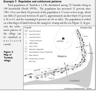
Example 7: Population and settlement patter ns. . . . 51
Example 8: Infrastructure. . . . 51
Example 9: O ccupations. . . . 53
Example 10: Education. . . . 54
Example 11: Land ownership. . . . 55
Example 12: Material style of life. . . . 56
Example 13: Ethnicity and religion. . . . 59
Example 14: For mal and infor mal associations. . . . 60
Example 15: Enabling legislation. . . . 64
Example 16: Community-level coastal resource management. . . . 70
Example 17: Seaweed far ming. . . . 77
Example 18: Fishing. . . . 81
Example 19: Perceptions of resource impacts from human activities— attitude scale reconstruction . . . . 91
Example 20: Perceptions of resource impacts from human activities— analysis of categorical data . . . 95
Example 21: Perceived quality of life and problems. . . . 97
Example 22: Problem identification . . . 101
Example 23: Village extension repor ting system and identification of contextual variables that can impact a project strategy . . . 109
Example 24: Monitoring and evaluating the implementation of an MPA . . . 112
Example 25: Time-1, time-2 comparison demonstrating use of controls. . . . 117
Page
Figure 1: Map of Minahasa villages. . . . 10
Figure 2: Map of Tumbak village. . . . 51
Figure 3: Evaluating individual perceptions using a seven-point scale. . . . 126
Figure 4: Example of a self-anchoring ladder indicating one respondent’s perception of positive environmental changes compared to the past and future . . . . 127
LIST OF TABLES
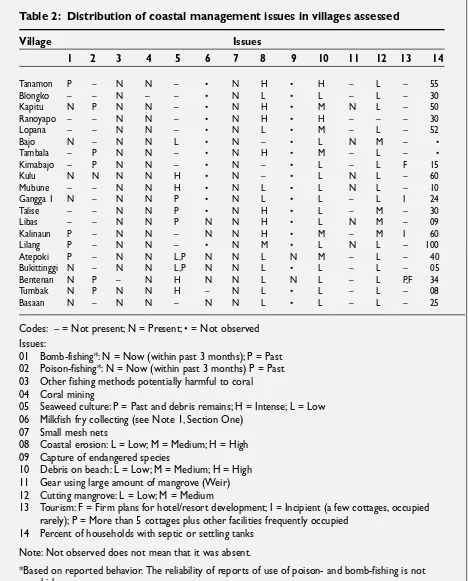
Page Table 1: Cross-tabulation of data gathering techniques and variables . . . 25Table 2: Distribution of coastal management issues in villages assessed . . . 37
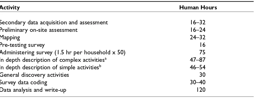
Table 3: Estimated time requirements for baseline assessment . . . 46
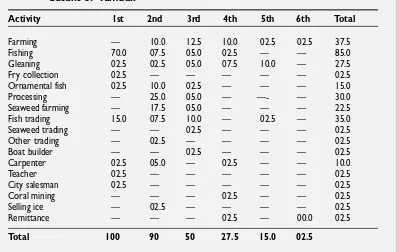
Table 4: Percent distribution of ranking of productive activities in coastal dusuns of Tumbak . . . 53
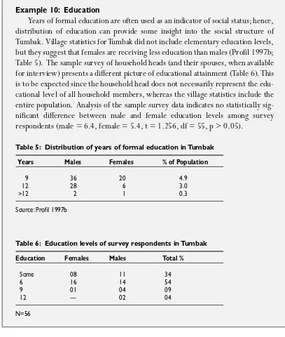
Table 5: Distribution of years of for mal education in Tumbak . . . 54
Table 6: Education levels of sur vey respondents in Tumbak . . . 54
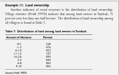
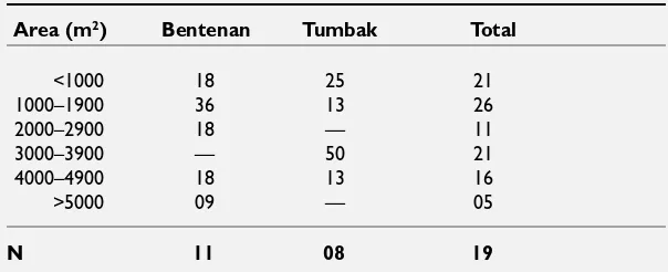
Table 7: Distribution of land among land owners in Tumbak . . . 55
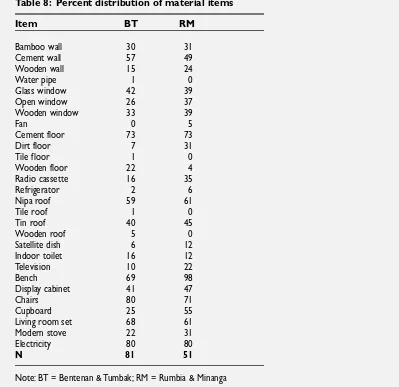
Table 8: Percent distribution of material items . . . 57
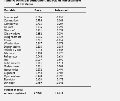
Table 9: Principal component analysis of material style of life items . . . 58
Table 10: Distribution (%) of rank of impor tance of seaweed far ming . . . 78
Table 11: Percent distribution of seaweed culture area . . . 79
Table 12: Percent distribution of seaweed culture labor by sex and age in sample households . . . 80
Table 13: Percent distribution of the relative impor tance of fishing . . . 81
Table 14: Vessel counts, March 1997 . . . 82
Table 16: Percent distribution of gear types used among sample households
in the capture fishery . . . 86
Table 17: Percent distribution of boat ownership among boat-using households using different vessel types . . . 86
Table 18: Percent distribution of gear ownership in households using it . . . 87
Table 19: Percent distribution of labor by age and sex categories for each gear type . . . . 87
Table 20: Percent distribution by age and sex for fish processing labor . . . 88
Table 21: Percent distribution by age and sex for fish trading labor . . . 88
Table 22: Percent distribution of scale values for Bentenan and Tumbak . . . 92
Table 23: Principal component analysis of beliefs about relationships between coastal resources and human activities . . . 94
Table 24: Resource beliefs component scores in villages . . . 94
Table 25: Percent distribution of the perception that bomb-fishers fish that way because it is a quick/ easy way to obtain fish/ money . . . 95
Table 26: Percent distribution of the perception that bomb-fishers fish that way because it is their way of making a living . . . 95
Table 27: Reasons for perceived changes cross-tabulated with village (reason # 1) . . . 98
Table 28: Reasons for perceived changes cross-tabulated with village (reason # 2) . . . 99
Table 29: Reasons for problems cross-tabulated with village (reason # 1) . . . 99
Table 30: Reasons for problems cross-tabulated with village (reason # 2) . . . 100
Table 31: Steps, actions, and outcomes expected from establishing a community-based marine sanctuary . . . 113
Table 32: Percent distribution of perceptions of changes in household well-being in Bentenan and Tumbak at time-1 and time-2 . . . 117
Table 33: Percent distribution of perceptions of changes in future status in Bentenan and Tumbak at time-1 and time-2 . . . 117
Table 34: Percent distribution of perceptions of changes in future status in Bentenan and Tumbak at time-1 and time-2 with collapsed categories . . . 118
Table 35: Percent distribution of perceptions of changes in household well-being over the past five years in project and control villages (July 1998) . . . 119
Table 36: Percent distribution of perceptions of future status in project and control villages (July 1998) . . . 119
Table 37: Percent distribution of reasons for change . . . 120
Table 38: Perceived pre-project to post-project changes in indicators . . . 129
Understanding the human aspects of coastal resources use is essential for effective coastal management, especially community-based coastal resources management (CB-CRM). Inclusion of good infor mation is essential if coastal managers are to ultimately demonstrate the benefits and impacts of CB-CRM. This manual breaks new ground in pro-viding guidance for collecting and utilizing rigorous quantitative and qualitative data as par t of CB-CRM effor ts as a complement to infor mation collected through more par tici-patory methods.
The Coastal Resources Center, through the Indonesia Coastal Resources Management Project, known in-country as Proyek Pesisir, has been working to develop and test inte-grated management approaches and practices that can be effective in the Indonesian con-text. Community-based coastal resources management is one “good practice” model being pioneered in Nor th Sulawesi. W hile experience in CB-CRM throughout Asia and globally is rapidly growing, Proyek Pesisir’s pilot effor ts in three Nor th Sulawesi sites— Blongko, Talise and Bentenan-Tumbak— are among the first such sustained initiatives in Indonesia. Since 1997, Proyek Pesisir has been working with these communities to prepare commu-nity profiles and CB-CRM plans. In late 1999, the plans were adopted by the communities themselves, as well as by the village leaders and the Minahasa Regency, making CB-CRM tangible in Indonesia.
Since it is our aspiration that these pioneering CB-CRM programs will be both an inspi-ration and example for many of Indonesia’s over 6,000 coastal villages, Proyek Pesisir made a major commitment to take a “scientific” approach to developing our model of CB-CRM. Such an approach seemed essential if we were to be able at the end of the project to say with confidence what impact the CB-CRM projects had; as well as where and how this approach should be replicated. W hile methodologies to look at the natural environment are relatively well-developed (and are not covered in this manual), practical methodologies aimed at understanding the human aspects of coastal resources use are few. Such information is essential for selecting CB-CRM sites, identifying and understanding coastal resource man-agement issues, and impor tantly, demonstrating the benefits and impacts of CB-CRM.
the impacts of CB-CRM projects. The methodological information is complemented with practical guidance about acquiring information in the field; and the utility of the informa-tion demonstrated through the use of a wide range of field examples from both Nor th Sulawesi and other nations working to establish viable CB-CRM. W hile developed for Indonesia, we believe the manual will be useful to practitioners globally as the problems it is designed to address— that of inadequate information on the human aspects of coastal resource use and the assessment of project results— are near universal.
As with any instrument, this guide needs to be applied carefully and appropriately. We commend it to you as a research tool that can augment the essential par ticipatory processes that are at the core of CB-CRM. We encourage your feedback to the authors on your expe-rience with its application.
Ian M. Dutton Lynne Zeitlin Hale
Chief of Par ty, Proyek Pesisir Associate Director, CRC
INTRODUCTION
1.1 BACKGROU ND
The purpose of this manual is to provide guidelines for assessing the behavioral aspects of resource use for community-based coastal resources management (CB-CRM) projects. W hy? First, we must be accountable in ter ms of justifying the money, time, and resources expended on such a project. We must be accountable to the people who suppor t the gov-er nments and organizations that fund these projects. We must also be accountable to the coastal communities that invest their time and labor, and take the ultimate risk that the CRM measures will improve, not diminish, their quality of life. They must be provided with some sor t of repor t card that infor ms them of a CB-CRM project’s progress and impact (Harwell et al. 1999).
Second, CB-CRM project management requires feedback on progress toward goals and objectives, so that, if need be, activities can be adjusted to fit the dynamics of change in coastal populations. This type of adjustment is referred to as adaptive management— a must in ecosystem management (Margoluis and Salafsky 1998).
W hile such infor mation has been useful to practitioners for building enthusiasm for the community-based approach, as well as adapting CB-CRM approaches to new situa-tions, it is impor tant to begin supplementing that approach with more systematic meth-ods. These methods will facilitate rigorous documentation of issues, testing of project logic/ hypotheses, and evaluation of project impacts. The methods described in this man-ual emphasize a systematic, empirical approach to obtaining detailed evidence of outcomes that can be attributed to a specific set of project inter ventions. Specifically, the methods allow testing hypotheses concer ning what constitutes best practices in the process of developing CB-CRM.
1.2 PU RPOSE AND SCOPE
The purpose of this manual is to help coastal program managers and scientists incorpo-rate systematic qualitative and quantitative assessment methods into the process-oriented work that is essential for viable community-based management. Specifically, the manual provides guidelines for assessing behavioral aspects of resource use for community-based coastal resources management projects. The emphasis is on human behaviors, factors influ-encing these behaviors, and the consequences of these behaviors for community well-being. It is impor tant to emphasize that the use of the concept “behavioral” is deliberate. Many non-social scientists refer to all infor mation on human behavior as “socioeconomic,” even when it includes obviously psychological factors such as attitudes, beliefs and values. Technically, socioeconomic involves only social and economic factors, neglecting the atti-tudes, beliefs and values that motivate much of human behavior. Another impor tant aspect of behavior that is neglected, in a strictly socioeconomic assessment, is the behavioral aspect of the deployment of technology. W hile socioeconomic studies consider technology— its costs, ownership and production— they usually omit descriptions of how the technology is used. Exactly the same technology can have completely different impacts on a natural resource when it is deployed in different ways. For example, some net deployment meth-ods result in entanglement in corals— breaking and otherwise damaging the living organ-ism. Hence, this manual also includes methods for describing significant aspects of behavior associated with technology.
Indonesian Coastal Resources Management Project, a cooperative effor t of the U.S. Agency for Inter national Development (USAID) and the Indonesia National Development Planning Board (BAPPENAS)) in its ongoing research, development and testing of best practice models for CB-CRM in Nor th Sulawesi, Indonesia.
A key assumption of this manual, with its emphasis on assessing human aspects of coastal resource use, is that the ultimate goal of CB-CRM is improvement of coastal ecosys-tem health, resulting in improvement in the quality of life for coastal communities. There are often different interpretations of what is meant by “community-level” with respect to CB-CRM programs. In this manual, we define community-level sites as areas encompassing:
• A coastal sub-village, a village, or several villages located on a small island or sur-rounding a small bay or estuary
• A collection of villages or sub-villages that uses the resources (for example, fish, coral, sand, mangroves) of a common coastal area
• A subgroup within a village that exploits a small ecosystem unit or collection of coastal resources within one area
factors). Finally, O lsen et al. (1999) developed a manual to assess the management capac-ity of a coastal management program. It reflects a qualitative approach to drawing lessons, with an emphasis on gover nance practices and inter ventions. Posing a series of questions at various stages in the program cycle, it is geared toward regional and national programs, rather than community-based initiatives.
1.3 LINKING TH IS GU ID E TO PARTICIPATORY ASSESSMENTS
Emphasis in this manual is not placed on par ticipatory methods. It is directed at obtaining systematic qualitative and quantitative data, and where appropriate, conducting statistical analysis of the infor mation gathered. The use of par ticipatory methods for obtaining some data, however, is not automatically ruled out. They are frequently an essential element of CB-CRM projects, and the fact they are not emphasized in this guide does not suggest otherwise. Par ticipatory approaches are useful to help build community suppor t for a CB-CRM initiative, to draw on the traditional community knowledge base, to raise awareness of socioeconomic and ecological trends and changes within the com-munity, and to build community capacity for sustained local-level management. Par ticipatory methods are not, however, always feasible, given the time constraints which often accompany CRM projects, par ticularly in the project site selection phase. They also have a number of limitations, usually requiring extensive preparation time if properly used, and having the potential of resulting in subjective infor mation with a relatively high level of community perceptual biases. This is a potential drawback to the par ticipatory method, since when developing or testing new approaches, decisionmakers often demand objective evidence that the new approach indeed delivered the intended benefits. Never theless, a par ticipatory process is an essential element of any CB-CRM effor t. A par ticipatory community planning and management process must be carried out concur-rent with, or immediately following, baseline assessment work. Results of the baseline assessments must then be fed back to the community and linked to the planning process. This guide sets for th methodologies for collecting data which complement, but do not replace, par ticipatory assessment techniques.
1.4 IN WH AT SITUATIONS SH OU LD TH IS MANUAL BE U SED ?
described here must be evaluated in ter ms of their suitability for specific projects. If nec-essary, they can be adapted and carefully applied to other situations.
O nce the pilot phase of CB-CRM is completed in an area, and the program is in the replication phase, neither the resources to conduct the extensive baseline assessments described in this manual may be available, nor the full suite of data described herein deemed necessary. In such cases, a subset of the recommended data may be more appropriate, and par ticipatory methods could play a more prominent role. However, if less infor mation is collected, then the knowledge base from which project inter vention decisions are made is more limited. This increases the risk that impor tant pieces of infor mation may be missing, and that project decisions may therefore not have intended outcomes. The project team must weigh the level of infor mation considered necessary against available resources. Finally, as with any assessment methodology, attention needs to be given to ensure that the assessment team has the experience and skills, as well as the resources, to apply the meth-ods recommended in this guide.
1.5 WH O SH OU LD U SE TH IS MANUAL?
This manual is directed at socioeconomic specialists and technical staff working on CB-CRM programs and projects. The infor mation and repor ts developed from the application of the assessment methods described are appropriate for a technical audience. W hile the infor mation obtained is useful for profiling human aspects of coastal resource use, the data acquired will not be in a for mat that is easily understood by client groups at the village level or by local gover nment officials. Hence, additional steps are needed to ensure that the infor mation collected through the methods in this manual is simplified and integrated into documents produced as par t of a project’s par ticipatory process. For example, in the first phase of the CB-CRM process, issue identification, projects typically develop a site profile document. The profile should involve a high degree of community input to identify key coastal resources management issues, document actual and perceived trends in resource condition and use, and help explain the causes and consequences of obser ved phenomena. Systematically collected quantitative and qualitative baseline infor mation (both socioeco-nomic and environmental), presented in a for m easily understood by community members and local gover nment officials, is an impor tant component of such a profile.
1.6 ORGANIZATION OF TH E MANUAL
Preliminary Appraisal and Site Selection
Chapter 2 describes relatively rapid appraisal techniques that can be applied to obtain a cursory over view of human resource use in the coastal zone of the target region. It then illustrates how to use this infor mation in the site-selection process.
Baseline Assessment and Problem Identification
O nce CB-CRM sites have been selected on the basis of data provided by the prelimi-nary rapid appraisal, it is necessary to obtain more detailed baseline infor mation from tar-get communities. Chapter 3 describes techniques for establishing a baseline for identifying coastal resource management issues, evaluating project impact, and testing aspects of the project’s logic (did project inter ventions have the hypothesized effect?).
Monitoring and Evaluation
Following implementation of CB-CRM activities, it is necessary to evaluate their impact on project communities. Chapter 4 provides examples of how to design continuing monitoring programs once a baseline is in place. These monitoring programs are designed to provide a methodology for producing CB-CRM project repor t cards (Harwell et al. 1999), and tracking impacts of various project activities. Finally, this section describes sys-tematic qualitative and quantitative statistical techniques for deter mining a project’s impacts on the human component of the coastal ecosystem during the final phase of the project or at some time after it has been completed. O nce again, it is assumed that parallel evaluations will be made concer ning biophysical conditions.
PRELIMINARY APPRAISAL AND SITE SELECTION
2.1 INTROD U CTION
Effective CB-CRM project design is highly dependent on accurate and timely infor ma-tion concer ning the distribuma-tion of habitats, people, and coastal activities throughout the target region. Frequently, available infor mation is old, incomplete or unreliable. The pur-pose of this chapter is to provide a methodology designed to generate infor mation essen-tial for the early stages of project design and site selection.
O f primary impor tance is adequate sampling of the diversity of communities and habi-tats included in the region. O nce the sample is selected, relevant infor mation must be com-piled for each sampling unit. This chapter outlines a sampling methodology, the types of infor mation required and methods for its acquisition, including the composition of the field team, preliminary preparations, transpor tation and accommodations, procedures for data acquisition, and validation techniques. It provides a detailed example of a preliminary appraisal that can be used as a model for preparing repor ts. Finally, it discusses using the appraisal as par t of the site selection process.
2.2 SAMPLING
of various points within this range. This is essential to maximize the chances that the lessons lear ned in the pilot communities are applicable to the widest range of communities in the target region.
An accurate description of the range of variation in the target region depends in large par t on the communities selected to provide data for the analysis. This is a sampling prob-lem, and as with all sampling problems, it is usually constrained by time and money. Ideally, if the sampling universe were large enough (hundreds or thousands of communities) and the budget and time constraints were generous, a simple random sampling technique could be used to select a sample of around 100 communities— the exact sample size being based on appropriate application of some type of statistical power analysis (Cohen 1988). Also ideally, if the sampling universe were small enough (less than 30) and the budget and time allowance large enough, all the communities could be sur veyed. Reality, however, often includes rather severe time and budget constraints, often of such magnitude as to rule out even stratified random sampling, resulting in the need to use some for m of purposive, rep-resentative sampling to achieve a minimally acceptable profile of the target region. Since many good books have been written dealing with the topics of simple random and strati-fied random sampling techniques (Hedayat and Sinha 1991, Henry 1990, Rosander 1977), the purposive, representative technique, under severe budget and time constraints will be described here. Variables used to make the sample representative are similar to those that would be used to stratify a simple random sample.
Purposive, Representative Sampling
Purposive, representative sampling is a technique used when financial and time con-straints prohibit a statistically acceptable sampling procedure. As long as its limitations are understood, it is the minimally acceptable method for characterizing the variation in a region of coastal communities for purposes of selecting representative sites for pilot CB-CRM projects. The limitations are as follows:
1. Results cannot be used to estimate population (regional) parameters. For example, if 20 percent of the sample sites manifest a certain characteristic, we cannot claim that 20 percent (with error estimates) of the communities in the region manifest this characteristic.
2. The smaller the sample, the more likely significant variation in the sampling uni-verse will be missed.
Procedure
The steps or procedure for selecting a sample of villages to be sur veyed for a rapid appraisal of a region are summarized below:
1. Deter mine time and financial constraints.
2. Using people knowledgeable of the area and available maps (preferably recent, detailed topographic char ts and aerial char ts), estimate travel time for various dis-tances between coastal communities using various available means of transpor tation (boat, motorcycle, automobile, bus).
3. With knowledge of available time and estimated travel time, and assuming on-site data collection time to be a minimum of 24 hours, calculate maximum sample size and subtract 20 percent to allow for unexpected problems (for example, engine failure, severe stor ms).
4. Compile available secondary infor mation on coastal communities and areas. This should include repor ts and statistics from regional and national statistics offices; fishery, agriculture, and forestry offices; as well as the most recent detailed topo-graphic, bathymetric, and aerial char ts available. Legislation applicable to the area should also be collected, since it may indicate sanctuaries, closed areas, etc. Also, if available, inter view knowledgeable local exper ts (university researchers, fishery agents, and private businessmen residing in the city who conduct business in the coastal communities).
5. Examine available infor mation and select criteria for sample selection based on what is available (population; percent fishers; fishing gear types; coastal characteristics, such as percent mangrove cover, presence of coral reefs, river mouth, island or mainland, rocky or sandy coastline, etc.; and geographic distribution).
6. Select sites based on these criteria.
If the results of the above procedure indicate a sample size less than 20, either adjust available resources to increase sample size or accept the fact that the limitations noted above will apply more severely and reduce the reliability of the assessment to a level that may be unacceptable.
Example 1: Sample selection procedure
Maximum time available for the appraisal was 30 days, including several days debriefing in project headquar ters following the completion of the first five or so communities. Examination of topographic char ts indicated that much of the area around the nor th coast and along the Maluku Sea coast would be difficult to access by automobile, and the islands off the nor th coast would require use of a boat; thus, it was decided that a boat would be the appropriate means of transpor tation. Given the length of coastline, estimated boat travel time, and the need to spend approxi-mately 24 hours in each community, it seemed reasonable to expect to finish an appraisal of at least 20 communities in 30 days.
A preliminary sample of communities and groups of communities was selected on the basis of official statistics concerning population, number of fishers in relation to farmers, and geographical position. Every effor t was made to select communi-ties reflecting the range of fisher/ farmer ratios, total population sizes, and location along the coast and offshore islands. Because of missing data in the statistics for some of the Maluku Sea coastal communities, several kecamatan (larger political divisions composed of a number of communities) were selected with the final deci-sion to be made in the field. This preliminary sample included 17 specific villages and four Maluku Sea coast kecamatan from which specific villages would be selected during the assessment.
Communities included in the final sample are indicated in Figure 1. As an example of the types of problems that can disr upt the best planned sched-ule, heavy seas prohibited use of the boat during the initial stage of the assess-ment, so the seven sites along the coast from Tanamon to Tambala were assessed using an automo-bile for transpor tation
between villages.
For-tunately a good road exists along this stretch of coastline.
2.3 INFORMATION NEED S AND METH OD S FOR
PRELIMINARY APPRAISAL
It is impor tant to realize that most projects allow very little time for this type of pre-liminary appraisal. The amount of time necessary for this impor tant process is frequently underestimated, often due to the mistaken belief that available secondary infor mation can be used to supply most of the necessary infor mation. The limitations of available secondary infor mation are as follows:
1. Available statistics are frequently five to 10 years out of date, an unacceptable prob-lem in a period of rapid change.
2. Infor mation concer ning impor tant variables (for example, number of fishers, types of coastal and marine activities) is frequently inadequate, sparse or unavailable. 3. It is frequently hard to assess the reliability and validity of the infor mation.
Use of Secondary Information
The second point above is very impor tant and will be discussed in detail, since it involves one of the most impor tant data points concerning coastal zone use. The number of fishers is frequently underestimated in census material, since the number repor ted almost always refers to full-time fishers. It is not unusual to walk the beach of a village and count two to three times as many boats as the number of fishers repor ted in official statistics. When boat owners are questioned, they say, “Yes, I am a farmer, but when I am not working in the field, or when there are many fish, I go fishing.” Household occupational multiplicity characterizes many rural coastal communities. In three out of four coastal communities where the authors recently conducted sur veys, more than half the households practiced four or more produc-tive activities (Pollnac et al. 1998). Many of these activities are significant for coastal re-sources management (fishing, seaweed farming, fish farming, fish processing and marketing, mangrove har vesting, coral mining). Never theless, they do not reliably appear in any pub-lished statistics. The sparseness or absence of data concer ning fishery activities is often due to fishery offices’ having limited resources for conducting sur veys. Hence, villages in the samples are usually widespread, and the frequency of complete sur veys is too low for the needs of the type of preliminary assessment necessary for CB-CRM development.
Available secondary infor mation (for example char ts, repor ts, statistics, legislation) should be collected as a par t of the procedure for sample selection. O nce the sample has been selected, cull secondary infor mation on sample communities for all infor mation rel-evant to the preliminary appraisal.
Information Requirements
As inadequate time is usually allocated for the preliminary appraisal, it is impor tant to specify a minimal data set that will provide a description of coastal activities and conditions sufficient for a superficial sketch of general conditions in the target area. Hence, there should be a clear rationale for every variable specified.
Population, distr ibution of population and population density are clearly related to coastal ecosystem health. They influence both pollution and intensity of resource exploitation. Productive activities (fishing, far ming, coral mining, mangrove cutting, etc. ) are directly related to coastal ecosystem health, and the occupations associated with these activities for m an impor tant aspect of community social organization. Discover ing the existence of potentially destr uctive practices associated with productive activities is especially impor tant. Different relationships between the people and the natural re-source are often reflected in, and influenced by, community social groupings (organiza-tions, ethnic and religious groups). They need to be accounted for in a preliminary appraisal for coastal resources management pur poses. Community infrastr ucture (roads, schools, medical care, markets, transpor tation) has direct links to many aspects of the coastal ecosystem, especially the economic value of coastal products and the quality of life of the human population.
It is also impor tant to deter mine major issues, such as perceived changes over the past five years in the overall well-being of the community, the condition of the fishery and the condition of other coastal resources exploited. Repor ts on these impor tant issues by key members of the community provide infor mation which otherwise may be impos-sible to discer n in a brief visit. Finally, a general description of the coastal geography is necessary, including outstanding oceanographic conditions (for example, destr uctive cur-rents or wave action); ocean depth nearshore; a minimal description of coral reefs, dis-tribution of mangrove, beach characteristics (including litter and erosion), and locations of rivers, streams and swamps. Infor mation on coastal geography will facilitate under-standing the existing relationships between the local population and their environment, and may also indicate potential problem areas. The foregoing represents the minimum essential data needed to provide an initial understanding of coastal management issues for a given target area.
Specification of Variables
1. Coastal Zone Physical Geography Prepare a general description of terrestrial ter-rain (for example, slope, land use); general coastal configuration and condition (bay, river, swamp, mangrove locations, estimates of size, shapes, etc.); composition (sand, pebbles, rocks, etc.), and extent of erosion, litter and runoff; nearshore bot-tom characteristics (slope, presence and general condition of coral); and any salient climatic or oceanographic conditions that influence human behavior (for example, strong currents, large waves, seasonal stor ms).
2. Population O btain present population of the community and population from the next previous census. This will per mit evaluation of recent population trends.
3. Settlement Pattern Describe whether houses and other structures are concen-trated (nucleated) in one area along the coast, dispersed, or in some combination (nucleated coastal and dispersed inland).
4. Land Area and Suitability for Agriculture
5. Occupations Find percent of population engaged in various occupations.
6. Coastal Activities Identify all coastal zone activities; for each, identify target
resource, methods and gear types (numbers of gear); who is involved, when, where, why (home consumption, market); and method of marketing and distribution. For tourism, identify types (for example, spor t fishing, sun bathing, diving) and facilities (number of dive shops, hotel rooms, beach facilities, etc.).
7. Community Infrastructure Deter mine numbers of hospitals, medical clinics, resi-dent doctors, resiresi-dent resi-dentists, secondary schools, primary schools, telephones, food markets, hotels or inns, restaurants, gas stations, banks, percent of homes with water piped to them, sewer pipes or canals, sewage treatment facilities, septic/ set-tling tanks, electric ser vice hook-ups, public transpor tation and paved roads.
8. Social Groups Find percent distribution of both ethnic and religious groups, names of all organizations identified by type, function, year formed and membership.
9.Major Issues Identify perceived changes over the past five years in a) overall well-being of the community, b) condition of the fishery and c) condition of other coastal resources exploited.
10. Destructive and Illegal Practices Deter mine presence of destructive techniques like use of poisons or dynamite, use of scare lines over coral reefs, anchoring on reefs, and/ or pollution of waters etc.
Data Gathering Methods
The Field Te am
The field team should be small (no more than three or four, including boatman or driver) to facilitate rapid movement and accommodations logistics, as well as to mini-mize disruptive effects in small coastal communities. At least one member of the team should be fluent in the local dialect of the language. The scientists (social and/ or bio-logical) should have broad experience in coastal communities with extensive knowl-edge of traditional and moder n coastal resource productive activities; they should be able to recognize most fishing gear and identify organisms with the aid of a guidebook. They should be in good physical condition, able to walk tens of kilometers a day, day after day, in the prevailing local weather conditions. They should be sufficiently adapt-able to go to sea with local fishers to obser ve fishing techniques, if necessary, and at least one should be able to use snorkel gear to obser ve the general condition of coral reefs, if present. Ideally, one would be a social scientist with extensive experience in small-scale and industrial fishing communities, and the other a marine biologist.
P relim inary Pre p ara tions
All secondary infor mation available should be reviewed and the required data abstracted for communities in the sample. Char ts should be carefully scrutinized and preliminary travel plans developed, maintaining flexibility, since field conditions may be better or worse than those depicted on the char ts. If available, local ter minology for coastal resources (flora, fauna, mineral) and gear and techniques should be compiled. This will facilitate data acquisition, as noted by a social anthropologist with extensive experience in coastal communities,
… furnished with the right word, one can get a direct answer to a question or under-stand a situation at once; without it, however correct one’s speech may be grammati-cally, one may often puzzle one’s informant or be reduced to giving and receiving laborious explanations which often irritate the person one is talking to. (Firth 1966:358)
If local taxonomies are not available, extra time should be allocated for the first site or a special trip should be made to a community in the region to compile preliminary taxonomies. A preliminary taxonomy should include most impor tant species and types of gear. This can be supplemented as the data collection procedure goes forward.
If necessary, per mission for travel through the area should be obtained. Also, if nec-essary, letters explaining the purpose of the exercise should be sent in advance to local community heads, so that they can be prepared for the team’s arrival.
Transport at ion and Accommodations
with a small, open cabin (see Example 1). The cabin was extended with a wooden framework and a tarp, and the team (human ecologist, marine biologist, boat driver and helper) slept on the boat, just offshore from the communities in the sample, pro-viding round-the-clock obser vation of coastal activities.
If transpor tation is by land, planning should account for the fact that many coastal communities are difficult to reach. The map may show a road connected to the coastal community, but roads along the coast are frequently in poor condition, and the com-munity center may be several extremely rough kilometers away from the coastline and coastal residents. Sometimes the coast cannot be accessed by motor vehicle at all, necessitating a time-consuming hike through terrain containing little infor mation of use to the preliminary assessment.
If it is necessary to arrange accommodations, all attempts should be made to stay in the sample community, despite the fact that most small r ural coastal communities do not have hotels or inns. In this type of sur vey, time is of the essence, and time spent traveling back and for th to an inn or hotel in another community is wasted. It is usu-ally possible to find someone in the sample community who has a spare room. This might involve sleeping on the floor, so be prepared. Accommodation in the sample community provides extra time, while eating and settling in for the night, to acquire infor mation that might otherwise have been missed in the brief time allocated for the assessment.
Lim it ations of the Dat a
It is impor tant to note that the limited time spent in each village places constraints on the process of verifying infor mation acquired by inter view. In many cases, it is pos-sible to make obser vations that can be used to validate cer tain types of infor mation. For example, if told that a cer tain type of resource use is carried out at night, attempts should be made to obser ve the practice; if told that no mangrove were har vested recently, the mangrove area should be examined, etc. O bser ved numbers of boats, by type, can be used to validate statements about the approximate number of fishers, etc. Some productive equipment, however, is small enough to be kept in the household or other closed storage place; hence, it is necessary to rely on infor mation provided by several infor mants (for example local fishers, fish buyers).
activity (see description in Example 3). This is a great weakness of rapid assessment techniques, especially with respect to coastal activities.
With these caveats in mind, it is never theless felt that if the infor mation is derived from inter views with several infor mants, combined with obser vation where possible, it does present a relatively reliable snapshot of practices of coastal resources manage-ment, relevant activities and conditions in the sample communities. It should, however, be used only as a preliminary over view, to stimulate fur ther investigation for deriving infor mation on which coastal management effor ts can be based.
P rocedures for Dat a Acquisition
Suggestions of procedures to be used for data acquisition are presented below for each of the specific variables discussed above. Alter native methods are suggested where appropriate, and estimates of reliability and potential pitfalls accompany many of the suggested methods.
COASTALZONEPHYSICALGEOGRAPHY A preliminary assessment of the physical geog-raphy of the coastal zone can be accomplished with the use of available topographic, bathymetric, and aerial photos and maps. Inter views with community officials and other key infor mants (fishers) can be used to supplement infor mation available in the published material and char ts. This preliminary description can be fur ther supple-mented and verified by obser vations made while walking the community and the beach, and snorkeling in the nearshore waters. W hile in the community (and while sail-ing along the coastline, if a boat is used), photographs should be taken to supplement the written repor t and jog one’s memory during repor t preparation. If the field worker cannot identify soils, etc., samples and photographs can be taken to exper ts for identi-fication, as necessary. The data needed is a general description of terrestrial terrain (for example, slope, land use); general coastal configuration and condition (bay, river, swamp, and mangrove locations, estimates of size, shapes, etc.); composition (for example, sand, pebbles, rocks); extent of erosion, litter and runoff; near shore bottom characteristics (slope, presence and general condition of coral, etc.); and any salient oceanographic conditions that influence human behavior, such as strong currents or large waves.
probe for an explanation. Sometimes two villages will merge into one, or one grows to the extent that it is split into two. Without this infor mation, one might repor t inaccu-rate population trends.
SETTLEMENTPATTERN There are several sources of infor mation for settlement pat-terns. First, in some cases, the community is required to prepare a map indicating land use. Many times, especially in smaller communities, these maps will indicate separate structures and can be used to determine settlement patterns. Second, unless there is dense tree cover in the community, recent aerial photographs, if available, can be used to determine settlement patterns. Recent topographic maps, if of appropriate scale, also indicate distribution of structures. In all cases, however, it is desirable to take a quick walk through the community as a means of validation. The walk-through will form par t of other data validation and collection procedures as well, justifying the time it takes.
LAND AREA AND SUITABILITY FOR AGRICULTURE Published statistics frequently include infor mation on land area and amount suitable for agriculture. The community map mentioned with regard to settlement patter ns may also be useful. These land fig-ures are also maintained by community officials in many countries; additional infor ma-tion may be derived from aerial photos.
OCCUPATIONS In some countries the percent distribution of different occupational subgroups can be obtained from published statistics. O ften, however, the data is aggre-gated at a higher level than the level of the community being assessed. In most cases, community officials keep statistics concer ning percent distribution into different occu-pational categories, which can be obtained easily. No matter what the source, one must keep in mind that these figures, both from community officials and published statistics, usually refer only to full-time par ticipants. Hence, significant numbers of par t-time par ticipants may be overlooked. Enumeration of boats and gear, discussed as a par t of obtaining data on coastal activities, may ser ve at least par tially to correct for this type of error. For example, if available infor mation indicates that there are five fishing fam-ilies in the village, but obser vation indicates 30 boats rigged for fishing, additional ques-tions to clear up the discrepancy are clearly needed.
COASTALACTIVITIES O btaining accurate data on coastal activities is not an easy under taking. They are usually seasonal, many take place out of sight of land, and activ-ities take place at all hours of the night and day. Since this is one of the most impor tant types of data collected in the assessment, a multi-method approach is advisable. Since this is also the most complex type of infor mation to be collected in the assessment phase, it is detailed in the sections below.
several days walking the waterfront, obser ving coastal activities such as fish landings, coral mining, mangrove har vesting, etc. At the same time, ask for the names of every activity, its associated equipment (boats, gear) and every coastal resource obser ved. Pay attention to minor variations between boat and gear types. The differences may signify not only a different type of vessel or gear (which will probably have a different name), but also different fishing methods and target species.
Walking around asking questions is a good technique for identifying knowledgeable individuals who are willing to provide useful infor mation. Keep in mind, however, that coastal activities are carried out at all times of the day and night, and the timing of the data gathering could result in bias if all times are not covered. Most producers like to talk about their activities to someone who is sincerely interested and also knowledge-able. Be prepared to answer questions concer ning methods you have seen elsewhere as well as to make comments about similar techniques, where appropriate. Such com-ments stimulate infor mants to provide even more detailed infor mation in hopes of lear ning something from the inter viewer.
A technique found to be useful for stimulating interest where fishing is a major activity is the use of a good fish identification guide, with colored pictures. Fishermen love to look at fish and talk about them. The process usually draws a small crowd— fish-ers, fish sellers and children— who will provide the local names of fish, as well as names for the techniques used to capture them. These taxonomies will not be simple. This is especially true for multi-species tropical fisheries where local taxonomies will name several hundred species (Pollnac 1998). Within the community there will also be some variation with respect to names. Fish sellers sometimes use more general terms (shark, rather than nurse shark) or a lingua franca (Indonesian, the national language of Indonesia, instead of Javanese, the language used by many Javanese). Coral reef fishers will tend to have more elaborate taxonomies of reef fish, while pelagic fishers may know fewer reef species. If the coastline is characterized by recent or past immigration from different areas, names may vary according to area of origin. Names should be cross-checked with several informants. If several names are provided for the same species, simply note that there are alternate names— a common finding. Photographs of any species one is unable to identify in the field can be brought to specialists for identifica-tion later. Warning: do not assume that the preliminary taxonomy of boats, gear and aquatic resources is complete. The degree of completion will depend on time and effor t used in its preparation, as well as the degree of local and inter-community variation.
appears to be well infor med, try to obtain percent distribution (or numbers) of differ-ent activities, gear types used, principal species targeted or cultivated, par ticipants (according to sex and age), seasonality, and distribution and marketing.
Resource use information obtained during initial inter views with community offi-cials should be verified by other sources of information, such as the enumeration and obser vations made during a walk through the community and along the coastline. General informational walks can be conducted at any time. Frequently, the most appro-priate time is following the initial inter view with community officials. Ask one of the officials if he has time to accompany you to the coastline. This act would show that the walk has been sanctioned by a higher authority. O bser vations of coastal activities can begin at this time, but the enumeration walk for fisheries activities should be done when most boats are at the shore, during non-fishing times. W hen walking the coastline, noth-ing should be overlooked— all unnatural looknoth-ing (for example, apparently manmade) structures and objects along the beach, in the water, in the boats, etc. should be identi-fied. O ne needs to develop the curiosity of a child, to learn to see again. Piles of coral, or coral in roadbeds or house foundations, are evidence of coral mining and should be investigated. Similarly, stacks of recently cut poles, logs for boats, and poles used in con-struction of gear or buildings suggest har vesting of forest resources. Buoys in the water are usually attached to something and poles protruding from the sea must have some function— ask what they are used for. Instances of coastal management field workers missing a several-hectare fish weir that looked like a stone wall in the sea have been obser ved. The field workers stated that they saw it, but never inquired about it. If a large fish weir can be overlooked, what about a small fish trap alongside a fisher’s dwelling?
For each coastal activity identified, as much of the following infor mation as possi-ble should be obtained from key infor mants:
• Number of people involved and their status (male, female, young, old, local, outsider)
• W hen (time of year, month, moon, tide, day)
•W here (where does the activity take place, what are the use rights)
• How much (what is the average har vest per boat or individual; what is the area and production of aquaculture ponds, etc.)
• W hy is the resource har vested? For home consumption or for the market (local or non-local)
• How is the resource gathered in ter ms of equipment and methods?
Boats and gear types should be enumerated using local nomenclature, either the pre-liminary taxonomy discussed above or one generated during the beach walk. Types of boats and gear should be queried until field workers are sure of the names. Small differences in hull shape, outrigger configuration or size may signify a different type of vessel, which may be related to a specific fishing technique. Likewise, minor differences in gear or deployment of gear are related to target species and potentially destructive techniques. For example, a gillnet suspended in the water column and fished passively has different potential impact on coral reefs than one which is fished by scaring the fish into the net with scare lines or poles dropped onto the coral. Motorized vessels can usually be dis-tinguished from non-motorized by the presence or absence of a motor mounting.
target species of each named technique? W hat is the work group size associated with each technique and how many groups are associated with each? W hat are its seasons?
Another significant obser vational method, used to identify techniques and species, is to identify landing places and landing times, and to be there to obser ve landings. Since landings will occur only once, or at most several times, during the brief initial assessment, this technique will suffer from the seasonality problem. Nevertheless, it has the positive aspect derived from the direct obser vation of behavior. Photographs should be taken of species that the field worker does not recognize for later identification by experts.
A supplemental technique for identifying impor tant species, seasonality and tech-niques, is to inter view fish buyers, who can also provide infor mation concer ning quan-tities entering the market, as well as marketing infor mation discussed below. As noted above, however, fish buyers often use names for fish that differ from those used by the local fishers.
O ne extremely effective method, which eliminates the timing problem and is use-ful for both species and technique identification, is to use a book, preferably with col-ored pictures, as a stimulus. Discussed above as a tool in preparation of a preliminary taxonomy, this technique should be continued throughout the preliminary appraisal. Fishers love to talk about fish and fishing techniques, and a picture book will usually attract a group with copious infor mation on the local taxonomy, as well as on fishing techniques and seasons.
Techniques analogous to those described above for fishing can be used to describe other coastal activities (for example, agriculture, aquaculture, coral mining, mangrove cutting, tourism). Community officials and par ticipants can be inter viewed, and obser-vation of activities and their physical evidence can take place.
The distribution and marketing of different target resources should be described (for example, home consumption, local market). Fishers, fish farmers, seaweed farm-ers, coral miners and others can be asked what is done with the different species (taken home to be used, sold directly to buyers on the beach, taken to a local market to be sold by retail sellers, hawked door to door in the village by the producer or by the producer’s wife, etc.). Buyers can be queried concerning where they buy and sell the resource and its ultimate destination (for example, international market, retail market place).
telephones, food markets, hotels or inns, restaurants, gas stations, banks, public trans-por tation and paved roads. W here possible, items on the checklist should be verified during the community walk-through.
SOCIALGROUPS Percent distribution of ethnic and religious groups can usually be obtained from community officials. Likewise, community officials keep records about for mal organizations such as cooperatives and other associations. The officials should be queried concer ning the type, function, year for med and membership of each for mal organization.
MAJORISSUES Several key infor mants should be inter viewed concer ning perceived changes over the past five years. First, community officials should be queried concer n-ing the overall well-ben-ing of the community. Second, fishers and/ or fish dealers should be inter viewed concer ning the condition of the fishery, and finally, individuals involved in the specific productive activities should be queried about the condition of other coastal resources exploited.
DESTRUCTIVE AND ILLEGALPRACTICES It is quite difficult to deter mine the presence or absence of illegal destructive practices like use of poisons or dynamite during a rel-atively brief preliminary assessment. W hen asked, community officials and local fishers usually say that they do not do it, and claim that it is done by fishers from elsewhere. An experienced obser ver can identify blast damage in coral, so if the diver is for tunate enough to snorkel over a damaged area (or if there is sufficient damage) it might be recorded during the brief assessment of bottom characteristics. If blast-fishing is prac-ticed daily, the obser ver may hear a blast during the minimum 24 hours allotted for each community in the preliminary assessment. Experienced obser vers can also assess blast damage in the catch (for example, ruptured air bladders and blood vessels, bro-ken bones, mutilated body par ts— see Ronquillo 1950). Evidence of material of poten-tial use for blast fishing (for example, bags of urea fer tilizer used in bomb construction) may be obser ved next to houses. If live fish are caught for the aquarium or food trade, cyanide may be used and evidence of squir t bottles or bottles of tablets (possibly cyanide) in boats landing fish suggest the need for fur ther investigation. Destructive practices which are legal (in some cases, these practices are illegal) can usually be read-ily obser ved, such as the use of scare lines over coral reefs, anchoring on reefs, or har-vesting of mangrove.
question is illegal, it is unlikely that they would admit the practice to an investigator who is conducting a one-day, rapid appraisal. Endangered species may be eaten locally sold whole, either live or dead, for human consumption or only cer tain products may be sold (bones, teeth, shells, eggs etc.). Look for live holding pens and tethers, evi-dence of products being prepared for sale (for example, shells, bones, or skins left out drying), and obser ve items being sold in the local market. O ther than that, a little luck and unceasing obser vation and questioning may unexpectedly uncover capture of ille-gal species during a preliminary appraisal.
It is impor tant to note that bags of fer tilizer, live fish trade, squir t bottles and bot-tles of tablets do not necessarily indicate illegal methods— they only suggest the need for fur ther investigation. The preliminary assessment is not the time to confront com-munity members concer ning illegal practices— the confrontation may adversely affect the community’s willingness to cooperate with the project. The obser ver’s role at this point is simply obser vation and repor ting obser vations to the project for future use or fur ther investigation.
Val i d at ion of Infor m ation
As noted above in the discussion of data gathering techniques, multiple methods are used for the same data type, wherever possible. The use of multiple methods, as well as multiple key infor mants, provides cross-validation for infor mation.1This is especially
impor tant when using outdated or questionable secondary infor mation, as well as when inter viewing key infor mants, including community officials. These infor mants may be attempting to provide you with accurate answers, but they simply may not know the correct answer or the type of infor mation most useful to the assessment. In other cases, they might not want to provide the correct infor mation. This is par ticularly true when the response may reflect negatively on them or their community, when they think a slight exaggeration may bring them a new project with funds, or when they think a cer-tain response may please you more than the truth. Selection of appropriate and reliable key infor mants is not an easy matter, and the time constraints of a preliminary appraisal make it more difficult.
1Some refer to this process as triangulation.
Example 2: The need for cross-validation
This example was selected because it illustrates several impor tant points. First, a high recommendation does not necessarily mean that the infor mant will be reliable for your purposes. In this case the infor mant had a great deal of interaction with marine scientists who gave him ideas about har mful fishing practices. He probably thought that the inter viewer would be impressed by a conser vation-oriented explanation for the demise of beach seining. Second, it illustrates the danger, when cross-validating a response, of asking leading questions. For example, the inter viewer did not approach other fishers and ask, “Did you quit using the beach seine because it har med the fishing by catching very small fish and shellfish?” That leading question would probably elicit a yes response. In the above case the inter viewer simply asked why beach seining was no longer practiced without making any suggestions. Third, since the infor mant was a respected, elderly individual, one can only speculate the impact he would have had on opinions expressed in a focus group.
inter viewed by one of the authors, he mentioned a species caught in a beach seine. Beach seines were no longer used in the area and he was asked why. He said fish-ers no longer used them because they knew that they took everything-small fish and shellfish-har ming the resource.
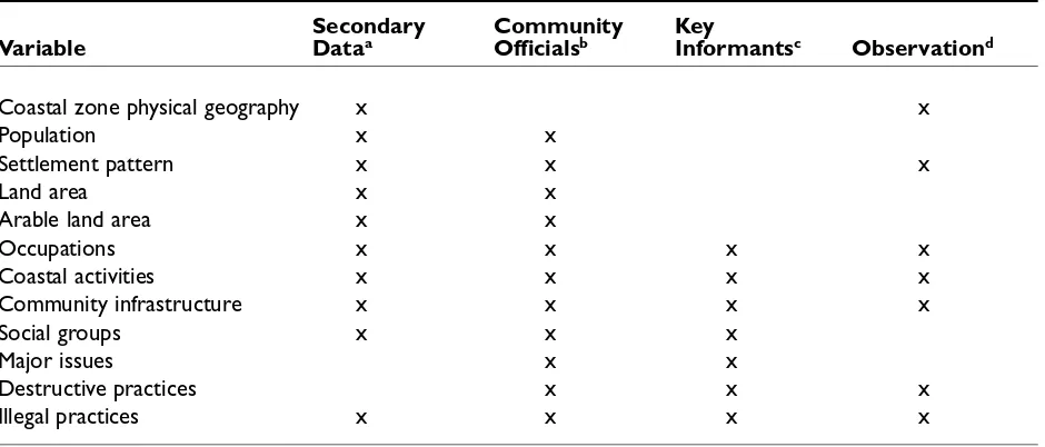
Summary of Information Needs and Methods for Preliminary Appraisal
Table 1 provides a summary of the preliminary appraisal data needs cross-tabulated with methods. This table should be used in combination with the text since it is merely a superficial summary.
Table 1: Cross-tabulation of data gathering techniques and variables
Secondary Community Key
Variable Dataa Officialsb Informantsc Observationd
Coastal zone physical geography x x
Population x x
Settlement pattern x x x
Land area x x
Arable land area x x
Occupations x x x x
Coastal activities x x x x
Community infrastructure x x x x
Social groups x x x
Major issues x x
Destructive practices x x x
Illegal practices x x x x
a Secondary data includes published statistics, reports, maps, legislation, etc. b Community officials include mayor, chief, secretary, etc.
c Key informants refers to any knowledgeable persons, including those inside and outside the community; gov-ernment agency personnel who have visited the community, researchers who have worked in the area, com-munity members involved in the activity being investigated, etc.
d Observation refers to observations made by the research team.The observations are made during beach walks, the community walk-through, sailing by on a boat, while participating in activities, and at all times while in or near the community. It should be a constant activity.
Example 3: Preliminary appraisal for one community
The following example is derived and modified from an actual preliminary assessment of coastal management issues in Nor th Sulawesi using the methods described above (Pollnac et al. 1997a).
BENTENAN
area a long stretch of cur ved beach, backed by brush, small trees, coconut palms and pasture, sweeps some 2.5 km south-southeast to Cape Popaya, a finger-shaped point of land scarcely .5 km from the wester n tip of Bentenan Island, a teardrop shaped island about .75 km by 1.5 km with its narrow end pointed toward the cape. At this point the coral reefs fringing both the mainland and the island almost meet. O ff the nor th shore of Bentenan Island the reef extends .75 to 1 km to the nor th. The village also has land on Bentenan Island. Most of the island remains as untouched forest. Kabupaten (Regency) statistics indicate that the village has a total land area of 800 ha, 650 ha classified as suitable for agriculture. The sea floor drops to 100 meters some 3.5 to 4 km offshore of the populated area.
Infrastructure Bentenan has a total of 10 km of roads (6 km asphalt, 2 km stone), and the rest dir t. Public transpor tation in the for ms of microlet (small van) and bus links the community to nearby towns and on to the capital of the kabupaten (Tondano) and Manado, some 100 km and three hours away. Belang, the nearest town with full ser vices (bank, gas stations, markets, gover nment offices), and the seat of the kecamatan (district gover nment) is a little over an hour and 20 km to the south. People and products can be transpor ted by the three pickup trucks, three microlet, six motorcycles, 11 oxcar ts and 21 bicycles recorded in the village statis-tics (Profil 1997a). Water piped from an inland source is available at several stand-pipes located throughout the community; approximately one-third (34 percent) of the households have septic or settling tanks. Electricity from the national electric company is available in the village, connecting approximately 60 percent of the homes. There are no telephones or gas stations. A small daily market operates in Dusun 3. The only restaurant and accommodations are located at the Bentenan Beach Resor t (Pollnac et al. 1997a). There are two primary schools (grades one to six) and one secondary school in the village. Thir teen teachers instruct the 159 pri-mary and 34 secondary school students (Profil 1997a).
establish a KUD (village cooperative unit) with a marine focus. The group is still in the for mative stages, and is being organized with the help of the owner of the Bentenan Beach Resor t (BBR).
Coastal activities The kepala desa classifies 50 percent of the population as far mers, 40 percent as fishers, and divides the rest among gover nment workers (mostly teachers), skilled workers and traders (shopkeepers, fish buyers). Agriculture comes right to the beach in the for m of coconut palms, while mari-culture and fisheries extend inland as milkfish ponds in the wetlands behind the beach. The beach and coastal waters are teeming with maritime activities. Stretching from the population centers, out and over the fringing reefs and reef flats to Bentenan Island, the coastal waters are densely covered with the multicol-ored plastic containers used as floats for seaweed culture. The shoreline, all along the populated area, is an unending strip of milkfish fry collectors, evenly spaced 10–15 m apar t along the beach. The density of the operations begins to thin out south of the village, as one moves to the tip of Cape Popaya, but does not disap-pear. Some milkfish fry collectors are even found on the west side of the cape, along the easter n shore of Sompini Bay. During the assessment, 95 milkfish fry nets were counted along Bentenan’s beach. Just to the nor th, and abutting the nor th edge of the residential area, a long row of thatched picnic/ beach shelters front the Bentenan Beach Resor t with its snackbar/ souvenir shop, seven red-roofed cot-tages, and its administrative building on the hills behind. Finally, the beach fronting the residential area is lined with fishing vessels, the smaller pulled up on the beach and the larger moored just offshore.
The fishing fleet of Bentenan consists of some 51 pelang without motor, 11 pelang with motor, three londe and four pajeko. Net types deployed include gillnets (soma kalenda, a drift net set at the edge of the seaweed culture areas), seine nets (soma roa and seser), and the mini-purse seine (soma pajeko). The pajeko at Bentenan do not use fish aggregating devices as in most other villages. Instead, a pelang pre-cedes the pajeko to the fishing grounds (about half an hour from the village) and lights a number of pressure lanter ns to attract fish. The pajeko follows about half an hour later and nets the fish. The entire operation is repor ted to take only several hours, from depar ture to landing.