USING ALOS DATA FOR CLASSIFICATION
OF LAND AND WATER USE IN NHA TRANG, VIETNAM
Phan Minh Thu1,2, Michael E. Schaepman3,
Rik Leemans2, Nguyen Tac An1, Tong Phuoc Hoang Son1
1
Institute of Oceanography, 01 Cau Da, Nha Trang, Khanh Hoa, Vietnam Email: [email protected], [email protected]
2
Environmental System Analysis Group, Wageningen University Droevendaalsesteeg 4, 6708 PB Wageningen, The Netherlands;
Email: [email protected]
3
Remote Sensing Laboratories, Department of Geography, University of Zurich Winterthurerstr. 190, CH-8057 Zurich, Switzerland
Email: [email protected]
ABSTRACT
The increasing availability of Earth observing satellites and instrumentation leads to increased image quality and quantity. The Advanced Land Observation Satellite (ALOS) provides three instruments: (1) Panchromatic Remote-sensing Instrument for Stereo Mapping (PRISM – 2.5m resolution), (2) Advanced Visible and Near Infrared Radiometer (AVNIR-2 – 10m) and (3) Phased Array type L-band Synthetic Aperture Radar (PALSAR – 2.5-10m). These instruments all provide improved opportunities for systematic land and water-use classification in coastal regions.
This study concentrates on the vicinity of Nha Trang City, Vietnam. We use atmospherically corrected ALOS AVNIR-2 data for supervised classification of land and water use. A hierarchical classification approach is used separating inland and coastal as well open water use types. On the land surface, land cover such as urban, cultivated land and aquaculture represented 10.1, 4.9 and 3.0% of total of land use, respectively. In the coastal and open water regions, eight ports and anchoring sites were located within semi-open waters, river mouths and nearby human settlements on islands. Also 23ha of marine culture was identified around Hon Mieu, northwestern Hon Mot and southern Hon Tre. Even though high spatial resolution ALOS AVNIR-2 data was used, some land cover types such as small houses, were difficult to identify. In addition, spectral similarities were found in marine culture cages and ships. Spectral similarities were resolved using a fusion technique or in-situ identification of these special types of land cover and water use. In general, the typical length scale (spatial, spectral) of ALOS AVNIR-2 data was sufficient to classify land cover and water use in a coastal region of Vietnam.
1. INTRODUCTION
et al., 2000; Richardson and LeDrew, 2006). Most studies, however, have only focused on lands or waters separately and did not classify land and water use for coastal zone management at the same time. The Advanced Land Observation Satellite (ALOS) images could meet these needs both in targeted coastal areas and in image quality.
The ALOS satellite, which was launched in 2006, is an earth observation system. Three instruments of ALOS provide high and medium spatial resolution imagery: (1) Panchromatic Remote-sensing Instrument for Stereo Mapping (PRISM – 2.5m resolution), (2) Advanced Visible and Near Infrared Radiometer (AVNIR-2 – 10m) and (3) Phased Array type L-band Synthetic Aperture Radar (PALSAR – 2.5-10m). Their products have been applied for estimation of gross primary production (As-syakur et al., 2010), classification of forests as well as estimation of water quality (Giardino et al., 2010) and environmental pollution (Le Minh Hang and Nguyen Dinh Duong, 2007). ALOS images have not widely been applied for the use of land classification. As-syakur et al. (2010), however, demonstrated the accuracy ratio of ALOS images analysis was similar with those results of Aster images. Therefore, in this paper, we use ALOS image to classify land and water use in coastal zones in Nha Trang (Vietnam) supporting coastal management.
2. MATERIALS AND METHODS
2.1. Study area
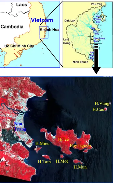
This study was carried out for both the land and water regions in Nha Trang City (Fig. 1). Because of the fast advancement of the city and restructuring its economy, land use in Nha Trang has changed rapidly. Nowadays, the economy of Nha Trang mainly focuses on the development of marine ecotourism and further development of marine resources. This has accelerated after Nha Trang officially became a level I city in 2009. Some regions are used as a marine protected area (MPA). These MPAs cover a region of 16,000 ha, including 3,800 ha of islands. The MPA are divided into three regions: core zones (located around Hon Mun, Hon Vung, Hon Cau, northeastern Hon Tre and a part of Bấy lagoon, and some regions were set up as rehabilitation zones), buffer zones (identified as a 300m belt surrounding core zone, Hon Mieu, Hon Tam and Hon Mot, as well as marine regions among Hon Tre, Hon Mot and Hon Mun), and transition zones (the remaining regions).
2.2. Study materials
The ALOS AVNIR-2 data were collected on July 17, 2007, and were used to classify land and water use in Nha Trang (Fig. 1). The ALOS image has 4 spectral bands: Band 1 - blue (420-500nm), band 2 - green (520-600nm), band 3 - red (610-690nm) and band 4 - near-infrared (NIR: 760-890nm) all with a spatial resolution of 10m. Geolocation of ALOS data was performed using available digital maps from Vietnam. All satellite data were reprojected into UTM with the WGS84 datum in zone 49N.
2.2. Classification method
value, an important parameter to identify the aerosol optical depth (AOD) for atmospheric correction, was estimated from the pixel value of short-wave infrared (SWIR, around 2.2 mm), blue (480 nm) and red (660 nm) bands. However, ALSO images do not have bands at SWIR. Thus, the AOD was estimated from the red and near-infrared (NIR) bands following Richter et al. (2006). Then, the image would be corrected by using their method with the rural model in ENVI’s ATCOR tool.
In the subsequent classification, land and water uses were classified separately because some land and water use types had similar reflectance value. For land regions, the image was divided into twenty-four classes, but after field trips and ground trusting, the number of classes was reduced to twelve. For water regions, the ports and anchor areas were also identified during the field trips. Water use was initially divided into twelve classes but later they were combined in just three classes: marine culture, anchoring sites and unused water.
3. RESULTS AND DISCUSSIONS
3.1. Land use classification
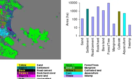
Land use in Nha Trang was abun-dant (Fig. 3). That contributed mainly to
natural land (including forests, a major part of rock/hard covered and bare land areas), urban (settlements) regions, cultivated lands and aquaculture (Fig. 3). Urban, cultivated land and aquaculture represented 10.1%, 4.9% and 3.0% of total of land use, respectively (Fig. 3b).
ALOS AVNIR-2 July 17, 2007 with 4 bands
Atmospheric correction
Land use status Water use status Sub-Images of study area
Radiometric calibration
Land use status Water use status
Figure 2. Flowchart of classification for land and water use with ALOS image in ENVI
Classi-fication Figure 1. Study area located within
ALOS AVNIR-2 data acquired on July 17, 2007 (false color).
These types were distributed in the centre of the Nha Trang region. A large part of the area consisted of natural land (Fig. 3). This type dominated mainly in mountains, islands and changing-land-use. In addition, the accuracy ratio of vegetable, cultivated and aquaculture regions was more than 83%, whereas that ratio of urban region (e.g. settlements) was about 61%. Urban regions were defined as the complex landscapes which combined houses, roads, soil, water, garden/vegetation and other infrastructures (Melesse et al., 2007), but in our study, the high resolution imagery allowed to limit urban regions to solely classify houses, buildings and roads. Thus, the estimated urban area was less than the actual urban area.
1 Purple 3 Rock/hard cover Magenta 1 Bare land
Gray Unclassified
Green 1 Forest/Trees
Green 3 Mangrove
Yellow 3 Cultivated land Cyan Aquaculture Thistle Swamp
Figure 3. Land use classes (left) and their spatial coverage (right) in Nha Trang estimated from ALOS data in 2007. Legend colors are selected according to water
quality impact.
However, the low accuracy ratio for urban areas was still caused by mixed pixels. Nha Trang has emerged from small towns and agricultural areas, with many small buildings (size < 5x5 m). There buildings in rural and sub-urban regions were part of the mixed pixels. Further, the increased dust from roads and construction sites caused changed the normal reflections. Therefore, these small-scale land use types in complex landscapes lead to an increasing the number of mixed pixels and this reduced the accuracy of the land use estimation. This was also observed by others (e.g. Melesse et al., 2007).
Figure 4. Application of PAN fusion method for ALOS data. Left: AVNIR-2 (10m resolution) data and right: PAN fused images (2.5 m resolution).
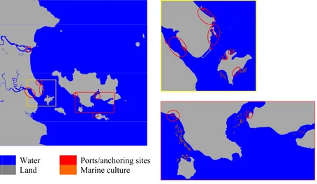
3.2. Water use classification
Like the land-use classification method, three water use classes were used in Nha Trang waters (Fig. 5). Eight ports and anchoring sites, which were identified by field trips, were used to separate the regions of marine culture. These sites were located at semi-opening waters (army, goods and tourism ports), river months (fishing boats anchoring sites) and nearby human settlement in islands (fishing boats anchoring sites). In addition, our estimates show that marine aquaculture covered 23ha of water. These marine cultures can lead to nutrient enrichment of the marine environment (Borja et al., 2009) and this impacts was considerably up to 50m from the actual sites. Therefore, these 23ha of aquaculture should be complemented with a buffer zone of 50m. Using the ENVI software, this results in an area of marine culture of 121ha.
Water Ports/anchoring sites
Land Marine culture
Figure 5. Water use classes in Nha Trang derived from ALOS data in 2007. Left: Full area, Right top and bottom: Zoomed to sensitive areas. Ports and anchoring sites are
4. CONCLUSIONS
We applied a supervised classification approach to corrected ALOS AVNIR-2 images to identify land and water use. The urban regions, cultivated lands, aquaculture (both, inland and in open waters) and ports/anchoring sites could be distinguished. Activities in these areas contribute considerably to the Nha Trang’s economy but also threat the environmental quality. Spectral confusion increased particularly in more complex landscapes and too small size of specific land and water uses, which when compared with the pixel size, negatively impacted the accuracy of the classification. However, these problems were minimized by using a PAN fusion approach with high resolution data from PRISM, and by classifying land use and water use separately. In conclusion, the ALOS AVNIR-2 and PRISM fused images added noticeably a promising innovative opportunity to study land and water with appropriate level of detaila. This is urgently needed for integrated coastal zone management together with making progress in the economic, social and environmental aspects of sustainable development.
Acknowledgments
The study was supported by Ford Foundation International Fellowship Program, Wageningen University – The Netherlands under Phan Minh Thu’s PhD scholarship. The ALOS-AVNIR2 image was used of ALOS-PI 326 project of Japan Aerospace Exploration Agency (JAXA). We would like to thank them for their contribution. We appreciate the support of R. Richter (DLR, German Aerospace Center, Remote Sensing Data Center, D-82234 Wessling, Germany) for his help atmospherically correcting ALOS data.
References
Antoine, D., Andre, I.M. & Morel, A., 1996. Oceanic primary production 2: Estimation at global scale from satellite (Coastal Zone Color Scanner) chlorophyll. Global Biochemical Cycles, 10, 57-69.
As-syakur, A.R., Osawa, T. & Adnyana, I.W.S., 2010. Medium Spatial Resolution Satellite Imagery to Estimate Gross Primary Production in an Urban Area. Remote Sensing, 2, 1496-1507.
Borja, Á., Rodríguez, J.G., Black, K., Bodoy, A., Emblow, C., Fernandes, T.F., Forte, J., Karakassis, I., Muxika, I., Nickell, T.D., Papageorgiou, N., Pranovi, F., Sevastou, K., Tomassetti, P. & Angel, D., 2009. Assessing the suitability of a range of benthic indices in the evaluation of environmental impact of fin and shellfish aquaculture located in sites across Europe. Aquaculture, 293, 231-240.
Bouvet, M., Goryl, P., Chander, G., Santer, R. & Saunier, S., 2007. Preliminary radiometric calibration assessment of ALOS AVNIR-2. Geoscience and Remote Sensing Symposium, 2007. IGARSS 2007. IEEE International, 2673-2676.
Giardino, C., Oggioni, A., Bresciani, M. & Yan, H., 2010. Remote Sensing of Suspended Particulate Matter in Himalayan Lakes. Mountain Research and Development, 30, 157-168.
Green, E.P., Munby, P.J., Edwards, A.J. & Lark, C.D., 2000. Remote sensing handbook for tropical coastal management, UNESCO Pub.
Melesse, A., Weng, Q., Thenkabail, P. & Senay, G., 2007. Remote Sensing Sensors and Applications in Environmental Resources Mapping and Modelling. Sensors, 7, 3209-3241.
Richardson, L.L. & LeDrew, E.F. (2006). Remote sensing of aquatic coastal ecosystem processes: Science and management applications, Springer, The Netherlands.
Richter, R., Schlapfer, D. & Muller, A., 2006. An automatic atmospheric correction algorithm for visible/NIR imagery. International Journal of Remote Sensing, 27, 2077 - 2085.