INAFOR 2015-PAPER D4
INTERNATIONAL CONFERENCE
OF INDONESIA FORESTRY RESEARCHERS III – 2015 21-22 OCTOBER 2015
INTEGRATED APPROACH FOR LAND USE CHANGE ANALYSIS AS
AN EFFORT TO CLIMATE CHANGE MITIGATION IN MEDAN NORTH
SUMATERA PROVINCE
Rahmawaty1, Monnica Zalukhu1, Abdul Rauf2
1Forestry Study Program, Faculty of Agriculture, University of Sumatera Utara, Jl. Tri Dharma Ujung No. 1
Kampus USU, Medan 20155, Indonesia email: [email protected]/[email protected]
2Agroecotechnology Study Program, Faculty of Agriculture, University of Sumatera Utara, Jl. A.Sofyan No. 3 Kampus USU, Medan 20155, Indonesia
Paper prepared for
International Conference of Indonesia Forestry Researchers III – 2015 (3rd
INAFOR 2015) 21-22 October 2015
INAFOR SECRETARIAT
Sub Division of Dissemination, Publication and Library RESEARCH, DEVELOPMENT AND INNOVATION AGENCY
MINISTRY OF ENVIRONTMENT AND FORESTRY
INTEGRATED APPROACH FOR LAND USE CHANGE ANALYSIS AS
AN EFFORT TO CLIMATE CHANGE MITIGATION IN MEDAN NORTH
SUMATERA PROVINCE
Rahmawaty1, Monnica Zalukhu1, Abdul Rauf2
1Forestry Study Program, Faculty of Agriculture, University of Sumatera Utara, Jl. Tri Dharma Ujung No. 1
Kampus USU, Medan 20155, Indonesia email: [email protected]/[email protected]
2Agroecotechnology Study Program, Faculty of Agriculture, University of Sumatera Utara, Jl. A.Sofyan No. 3
Kampus USU, Medan 20155, Indonesia
ABSTRACT
Changes in land uses is among the important issues in North Sumatra, especially in the city of Medan. To support climate change mitigation, this study aimed to analyze changes in land use during the period 2000 to 2011 and to identify main factors affecting the changes of land uses in Medan city. This study was conducted from March to August 2013. The Geographic information system (GIS) with overlay technique was used to analyze land use changes. The analytical hierarchy process (AHP) with questioner and interview was used to determine the cause of changes and the factors driving the changes in land use. Field observations were also undertaken to assess the biophysical conditions due to changes in land use. The results showed that for eleven years, the greatest extensive changes in land use were in the form of dry land farming mixed shrubs become dry land agriculture, followed by changes in rice fields becomes settlement. Other land use changes that affect widely were changes of shrubs into oil palm plantations and fish pond. Economic factors were the main cause of changes, followed by social factors and ecological factors. Economic criteria selected by respondents showed as the most important priority for activities in Medan City, that cannot be separated from economic activities that has strong alignment with spatial development. Changes on land uses basically is influenced by economic or financial considerations of agricultural land that has been converted into non-agricultural use, either for residential, offices, and other facilities. In order to mitigate climate change in Medan City, role of all stakeholders, especially local governments should be improved in order to minimize in land uses.
Keywords: AHP, climate change, GIS, Medan City, mitigation, plantation
1. INTRODUCTION
Some of these studies explain on how changes in forest land into plantations, agricultural land into non-agriculture. Other studies show on mangrove forest that turned into ponds, also changes on the uses of rice fields to other uses. Human activities brought on the changes of urban land uses from year to year. According to Parengkuan (1991) that urban activities will grow if the population is growing. Because the land is permanent, some land will be contested by the activities that have criteria in accordance with the land is located. Competition in land use has accumulated and caused land originally allocated for a particular activity in the city plan, often been used by other types of activities at implementation.
Human needs on goods and space impact on land use change. Increased interaction between people and land influence on the land use change. Remote sensing technology and Geographic Information System (GIS) are suitable methods to monitoring land cover change and to support management effort of these resources sustainability. Analysis of factors causing changes in land cover using Analytical Hierarchy Process (AHP) can provide several solutions in Medan to improve the situation. This study aimed to analyze changes in land use in the period 2000 to 2011 and to identify the main factors causing the changes of land use in Medan North Sumatera Province.
2. MATERIALS AND METHODS
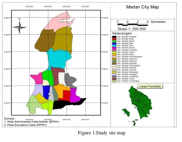
This study was conducted fromMarch to August 2013. Data collection was conducted from March 2013 to April 2013, and the data analysis was conducted from May 2013 to August 2013. The research was undertaken in the area of Medan, North Sumatra Province (Figure 1). Data processing was performed at the Laboratory of Integrated Forest Management Department of Forestry, Faculty of Agriculture, North Sumatra University.
The Geographic information system (GIS) with overlay technique was used to analyze land use changes. The analytical hierarchy process (AHP) with questioner and interview was used to determine the cause of changes and the factors driving the changes in land use. Field observations were also undertaken to asses the biophysical conditions due to changes in land use.
All data (thematic layers) gathered from different offices were projected on UTM (Universal Transverse Mercator) Zone 47 N before determination of land use/land use change. Then, Land use/land use change in the area was determined by overlaying maps of different periods, using ArcView GIS and ArcGIS (multi-thematic intersect operation). The data gathered were encoded in the computer using the spreadsheet program (Microsoft Office Excel) and output tables were exported as data based file (dbf) table.
Figure 1:Study site map .
3. RESULTS AND DISCUSSION
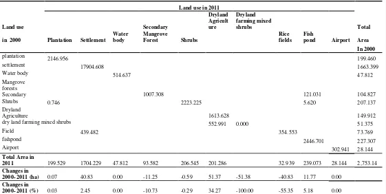
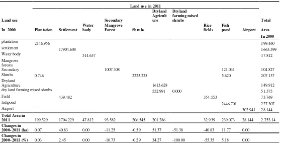
Landuse in the city of Medan consists of ten types according to Ministy of Forestry land cover map, namely: Secondary Mangrove Forests, ponds, settlements, oil palm plantations, rice fields, Shrub lands, Airport, Dry land Agriculture, dry land farming mixed shrubs, and Body Water (Table 1 and Figure 2). Based on the results of ground checking, the value of an accuracy of 96.25 % i.e. 80 points are 77 determined the correct point in a spreading ground check. It shows that the results of the interpretation of the maps are accurate. According to Rahmawaty et al.(2012), the accuracy level of ≥ 80 is considered to be correct. The matrix extensive changes in land use in the city of Medan during the period from 2000 to 2011 can be seen in Table 1. The dominant changes of land area from 2000 to 2011 occurred on Shrubs become fish pond, (Table 1). Extensive land cover in 2011 showed an increase for settlement from 439.48 Ha (2.45%) to 18 344.09 Ha or 61.90%, oil palm plantation area from 2147.70 Ha or 7.25% to 18344.09 Ha or 61.90%, agricultural from 2166.62 Ha or 7.31% to 2573.35 Ha, or 8.68% of the total land area of the city of Medan. Extensive land cover in 2011 showed an decrease for shrub swamp from 2223.23 Ha or 7,50%, rice fields from 354.55 Ha or 1.20% of the total land area. Dry land farming mixed shrubs has decreased drastically in which this land use may no longer exist in 2011 (Figure 2). On the other land use types that did not change with no addition or reduction in the extent of the body of water, secondary mangrove forests, and airports. Matrix of extensive changes of land use in Medan from 2000 to 2011 is presented in Table 1.
Table 1. Matrix land use changes in Medan city for the period 2000 to 2011
dry land farming mixed shrubs 552.991 0.000 51.375
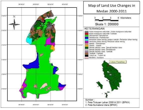
Figure 2: Map of Land Use Changes in Medan City
Based on observations and field surveys and maps of land use change in Figure 1, it can be seen that the location of changes in land use secondary mangrove forests into farms is located in the coastal area of Medan, namely district of Medan Belawan, Medan and Medan Labuhan Marelan. The potential of the coastal area is very supportive of the change. The coastal area in terms of various designations is a highly productive area. It became one of the causes of the changes to the mangrove forest. Changes occur can also be caused by a variety of interests and human activities. This is consistent with that expressed by Onrizal (2010) which stated that the change of the primary and secondary mangrove forests into non-forest areas caused by the conversion of mangrove, especially clearing forests for farms, oil palm plantations, settlements and other agricultural areas, the same was also presented by Rahmawaty et al (2011).
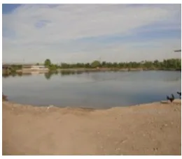
Human activities in urban areas, especially in the city of Medan which has been in the development stage were very rapidly pressing the existence of mangrove ecosystems with a view to economic aspects in meeting the needs of the surrounding community. Based on observations and field surveys, dry land farming mixed shrub turned into dry land agriculture may be because local communities using land that is not functioning initially located in the area of their agricultural land to expand agricultural land. Dry land agriculture commodities can be produced in larger quantities than before and there is no land is no longer productive. The land use changes are found in Marelan Sub District. Changes in land use shrubs into the pond through the observation of many found in Marelan Sub District (Figure 3 and 4). This is because the presence of Marelan which is the coastal area of Medan so it can potentially be a pond land. Communities also want to take advantage of nonproductive land at an earlier time to become ponds that can be productive and meet the needs of the community.
Figure3: Changes from mangrove forests into fish pond in Marelan Sub District
Figure 4: Changes from scrub into fish pond in Marelan Sub District
Likewise to changes in land use shrubs to oil palm plantations located in Medan Belawan Sub-district. Society is just solely utilizing non productive land into productive land. Moreover, the city of Medan is one of the coastal areas of the East Coast of North Sumatra, according Purwoko (2009). The agricultural sector has a strategic potential for development in Pantai Timur of North Sumatra, because the land is fertile and suitable for food crops, horticulture and plantation crops.For paddy fields land use changes into this settlement occurred in several Sub-districts in Medan city, namely: Medan Helvetia, Deli, Polonia, Selayang, Johor, Amplas, and Medan Area. Land use settlements as has been observed is dominating land use in Meda. This is due to the rapid development in various fields and high population growth, more lands are needed for the construction of various sectors as well as for tourist attractions. Viewed from the physical contours of the flat rice fields have potential and fit for settlement so that society or the various parties to convert them into settlements. This is consistent with the statement of Irawan (2005) and Rahmawaty (2011) which stated that the greater conversion occurs in rice fields compared to dry land because it is influenced by three factors and one of them is the development of non-agricultural activities such as residential complexes, shops, offices, and industrial areas easier carried out on paddy land is more flat compared to dry land.
reduced the amount of rice production. In addition, the decrease in agricultural land area, it can be indicated to the increasing number of buildings constructed in the city of Medan. The dominant factor influencing the decision of farmers in converting land productivity and the proportion of income is from agriculture.
Changes in secondary mangrove forests and shrubs into fish ponds by observation can occur due to changes in the region. According to Rabiatun ( 2012) in his research on Land Suitability Analysis and Settlement Policy in the Coastal Region of Medan, the coastal region is a unique area because it is a mixture of land and sea, it affects the physical conditions which are generally located in the surrounding area sea has a relatively flat contour. The existences of these conditions are very favorable for coastal areas used as areas of potential in the development of the whole region. Land use changes during the period 2000 to 2011 to change shrubinto palm oil plantations, and dryland farming mixed shrub became dry land agriculture occurs due to the mindset of the people to take advantage of unproductive land into productive. In addition, the land use changes occur in many coastal areas are also due to the potential and the physical state of the coastal area. According to Purwoko (2009) that the agriculture sector has a strategic potential for development in the East Coast region of North Sumatra, because the land is fertile and suitable for food crops, horticulture and plantation crops.
The dominant factors that cause changes in land use in Medan by using AHP analysis, was obtained by weighting the results of recapitulation weighting of criteria each respondent. Most of the respondents chose the economic criteria as the dominant factor causing changes in land use (0,425) or ranking1 in relation to the target or goal in a hierarchical structure. Furthermore, the social criterion is0.422 or ranking 2 and ecological criteria is 0,153 or ranking 3. Economic Criteria chosen as the most important priority by respondents as it is considered that the activity in the downtown area cannot be separated from economic activities that have a spatial alignment with development. This is also confirmed in research by Gani (2004) of the Land Use Pattern Changes in Binjai Based Land Use Relationship with Growth, stating that population growth and economic development for the city resulted in changes of urban land uses that will change the layout of the city. Therefore, economic criteria can be used as a dominant factor influencing changes in land use in the city of Medan.
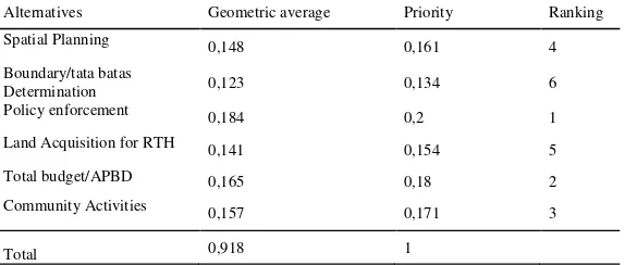
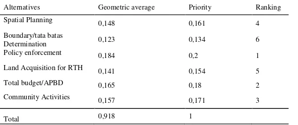
Based on calculations using the expert choice in AHP analysis method, in the same way with the calculation criteria for the calculation recapitulation of alternative level of each respondent can be seen in Table 2.
Table 2. Summary of the final calculation of alternative level of each respondent Alternatives Geometric average Priority Ranking
Spatial Planning 0,148 0,161 4
land acquisition for RTH (0.154) and the determination of boundaries (0.134).Alternative policy enforcement chosen becomes the most important priority in accordance with the target structure of the hierarchy. They assume the policies set by the government for each space that make the city respond to human influence in it is very influential on land use change. Article 7 LAW No. 26 of 2007 also emphasized the importance of policy enforcement. Control on land uses is done through permit utilization of space, provision of incentives and disincentives, as well as the imposition of sanctions. Utilization of space that is not in accordance with the spatial plan, both of which are equipped with a license or not having a permit, subject to administrative sanctions, sanctions of imprisonment, and / or criminal penalties.
Lack of policy enforcement effect on land use change in Medan city. That can also be seen from the research results of Nababan (2012) about Studies on Land Use in the Bagan Deli Village which concluded that the lack of socialization of the RTRW make people do not understand and do not know the direction and policies. They became one of the factors of change in land use. Many housing and settlements had already been constructed with or without permit, and these constructions do not follow rules of the Spatial Plan of Medan City from 2011 to 2030. The city government should issue policies related with eviction,compensation, or relocation.
Medan city is dominated by residential land use which shows that the development and utilization in Medan over the demand of buildings for various fields as well as tourist attractions. This certainly influenced agricultural land converted into non- agricultural use either for housing, offices and other facilities. Therefore, it takes the role of government policy to provide good assertiveness through socialization RTRWK or in the case of IMB (Building Permit). As well as research of Supriyadi (2004) states that there are at least three important factors that lead to rice fields function transfer one of which is the aspect of regulations issued.
A close relationship between the alternative criteria that become dominant factors that cause changes in land use in the city of Medan is the economic and policy enforcement. According to Sitorus (2004), almost every human activity involves the use of land and because of the amount of human activity is growing rapidly, the land becomes scarce resource. The decision to change the land-use patterns may provide substantial gains or losses, both in terms of economic and environmental changes. Thus, making decisions about land use is heavily influenced by political activity as well associal and economic circumstances.
4. CONCLUSIONS
During eleven years (the period 2000- 2011), extensive changes in land use were greatest in dry land farming mixed shrubs become dry land agriculture, followed by changes in rice fields becomes settlement. Other land uses that also extensive changes are shrubs that turned into oil palm plantations and fish pond. The dominant factors that cause changes in land use in the Medan city based on AHP analysis is policy enforcement in terms of the economy.
REFERENCES
Alamsyah. (2011). Analysis of Factors Affecting Decision Making Being Conversion of Agricultural Land Settlement in Medan (Analisis Faktor-Faktor yang Mempengaruhi Pengambilan Keputusan Atas Konversi Lahan Pertanian Menjadi Permukiman Di Kota Medan). USU Press. Medan
As-syakur, A.R. (2011). Changes in land use in the Province of Bali (Perubahan Penggunaan Lahan di Provinsi Bali). Jurnal Pusat Penelitian Lingkungan Hidup. Ecotrophic, Vol 6, No. 1: 2011
Food and Agriculture Organization (FAO). (1995). Planning for Sustainable Use of Land Resources. FAO Land and Water Bulletin 2. Rome: Food and Agriculture Organization of United Nations.
Gani, T. (2004). Changes in Land Use Patterns in Binjai Based Land Use Relationship With Growth (Perubahan Pola Penggunaan Lahan Kota Binjai Berdasarkan Hubungan Penggunaan Lahan dengan Pertumbuhan) . Tesis Sekolah Pascasarjana Universitas Sumatera Utara. Medan.
Irawan. (2005). Conversion of rice field: Potential Impact, Utilization Patterns and Determinant Factors (Konversi Lahan Sawah : Potensi Dampak, Pola Pemanfaatannya, dan Faktor Determinan). Forum Penelitian Agro Ekonomi Volume 23, Nomor , Juni 2005. Bogor : Pusat Analisis Sosial Ekonomi dan Kebijakan Pertanian.
Nababan, B. (2012). Study of Land Use in the Bagan Deli Village (Kajian Tata Guna Lahan di Kelurahan Bagan Deli). USU Press. Medan.
Onrizal. (2010). Mangrove Forest Change on the Pantai Timur of North Sumatra Period 1977-2006 (Perubahan Tutupan Hutan Mangrove di Pantai Timur Sumatera Utara Periode 1977-2006). Jurnal Biologi Indonesia. Bogor: DIPA Puslit Biologi-LIPI Bogor.
Panjaitan, S. (2013). Urban Land use changes in Tanjung Sari district Medan Selayang (Ethnographic Studies On Agricultural Land use changes Being Non - Agricultural Land In the of Tanjung Sari village of Medan Selayang subdistrict (Alih Fungsi Lahan Di Perkotaan, Kel.Tanjung Sari, Kec. Medan Selayang (Studi Etnografi Tentang Alih Fungsi Lahan Pertanian Menjadi Lahan Non-Pertanian Di Kelurahan Tanjung Sari Kecamatan Medan Selayang-Medan)). USU Press. Medan
Parengkuan, E. (1991). Study of the City Land Tax Issues in Relation to the Land Use and Control of Land Use in Bandung City (Studi Permasalahan Pajak Lahan Kota dalam
Kaitan dengan Penggunaan Lahan dan Pengendalian Guna Lahan di Kotamadya Bandung). Jurnal PWK,Triwulan II/April, Bandung: LPP-ITB.
Purwoko, A. (2009). Analysis of Land use Change in Coastal Regions Using Satellite Imagery -Based Geographic Information System Case Studies in Margasatwa Karang Gading dan Langkat Timur Laut (Analisis Perubahan Fungsi Lahan di Kawasan Pesisir dengan Menggunakan Citra Satelit Berbasis Sistem Informasi Geografis Studi Kasus di Kawasan Suaka Margasatwa Karang Gading dan Langkat Timur Laut). Wahana Hijau. Jurnal Perencanaan dan Pengembangan Wilayah. Vol. 4 No.3 April 2009.
Putra, S. H. (2011). Mapping of Land Use Changes in the Coastal area at Medan and Deli Serdang (Pemetaan Perubahan Tutupan Lahan di Pesisir Kota Medan dan Kabupaten Deli Serdang). USU Press. Medan
Rabiatun. (2012). Land Suitability Analysis and Settlement Policy in the Coastal Region of Medan (Analisis Kesesuaian Lahan dan Kebijakan Permukiman di Kawasan Pesisir Kota Medan). USU Press. Medan
Rahmawaty, T.R. Villanueva, and M.G. Carandang. (2011). Participatory Land Use Allocation. LAP Lambert. Saarbrucken, Germany.
Rahmawaty., Y. Afiffudin., H. Kurniawan. (2012). Application of Geographic Information Systems (GIS ) In Reviewing Deployment Palm Oil In Forest Area (Aplikasi Sistem Informasi Geografis (SIG) Dalam Mengkaji Penyebaran Perkebunan Kelapa Sawit Pada Kawasan Hutan). Prodsiding Seminar llmiah dalam rangka DiesNatalis USU ke-59 (SI-DIES 2011).
Sitorus, S.R.P. (2004). Evaluation of Land Resources (Evaluasi Sumberdaya Lahan). Penerbit Tarsito. Bandung
Supriyadi, A.( 2004). Land Policy and Process of land Conversion of Agricultural Land (Kebijakan Alih Fungsi Lahan dan Proses Konversi Lahan Pertanian. Fakultas Pertanian). Bogor: Institut Pertanian Bogor.
Jurnal
Author, A.A.. (Publication Year). Article title. Periodical Title,
Volume(Issue), pp.-pp.
Nevin, A. (1990). The changing of teacher education special education.
Teacher Education and Special Education: The Journal of the Teacher Education Division of the Council for Exceptional Children, 13(3-4), 147-148.
Author, A.A.. (Publication Year). Article title. Periodical Title,
Volume(Issue), pp.-pp. doi:XX.XXXXX or Retrieved from journal URL Book
Author, A.A.. (Year of Publication). Title of work. Publisher City , State: Publisher.
Finney, J. (1970). Time and again. New York, NY: Simon and Schuster.
Eggers, D. (2008). The circle [Kindle Version]. Retrieved from http://www.amazon.com/
INAFOR 2015-0XXX
INTERNATIONAL CONFERENCE OF INDONESIA FORESTRY RESEARCHERS III - 2015
(3rd
INAFOR 2015)
21-22 OCTOBER 2015
INTEGRATED APPROACH FOR LAND USE CHANGE ANALYSIS AS
AN EFFORT TO CLIMATE CHANGE MITIGATION IN MEDAN CITY
INAFOR SECRETARIAT
Sub Division of Dissemination, Publication and Library FORESTRY RESEARCH AND DEVELOPMENT AGENCY
INAFOR 2015-0XXX
INTERNATIONAL CONFERENCE
OF INDONESIA FORESTRY RESEARCHERS III – 2015
21-22 OCTOBER 2015
INTEGRATED APPROACH FOR LAND USE CHANGE ANALYSIS AS
AN EFFORT TO CLIMATE CHANGE MITIGATION IN MEDAN CITY
Rahmawaty1, Monnica Zalukhu1, Abdul Rauf2
1Forestry Study Program, Faculty of Agriculture, University of Sumatera Utara, Jl. Tri Dharma Ujung No. 1
Kampus USU, Medan 20155, Indonesia email: [email protected]
2Agroecotechnology Study Program, Faculty of Agriculture, University of Sumatera Utara, Jl. A.Sofyan No. 3 Kampus USU, Medan 20155, Indonesia email: [email protected]
Paper prepared for
International Conference of Indonesia Forestry Researchers III – 2015 (3rd
INAFOR 2015) 21-22 October 2015
INAFOR SECRETARIAT
Sub Division of Dissemination, Publication and Library FORESTRY RESEARCH AND DEVELOPMENT AGENCY
INTEGRATED APPROACH FOR LAND USE CHANGE ANALYSIS AS
AN EFFORT TO CLIMATE CHANGE MITIGATION IN MEDAN CITY
Rahmawaty1, Monnica Zalukhu1, Abdul Rauf2
1Forestry Study Program, Faculty of Agriculture, University of Sumatera Utara, Jl. Tri Dharma Ujung No. 1
Kampus USU, Medan 20155, Indonesia email: [email protected]
2Agroecotechnology Study Program, Faculty of Agriculture, University of Sumatera Utara, Jl. A.Sofyan No. 3
Kampus USU, Medan 20155, Indonesia email: [email protected]
ABSTRACT
Changes in the land use are one of the important issues in North Sumatra, especially in Medan city. In order Tto support mitigate climate change mitigation, this study aimed to analyze changes in land use in during the period 2000 to 2011 and to determine the main factor causing the change of land use in Medan city. This study was conducted in from March to August 2013. The Geographic information system (GIS) with overlay technique was used to analyze land use changes. The analytical hierarchy process (AHP) with questioner and interview was used to determine the cause of changes and the factors driving the changes in land use. Field observations were also made undertaken to assess the biophysical conditions due to changes in land use. The results showed that during for eleven years, the greatest extensive changes in land use were weregreatest in dry land farming mixed shrubs become dry land agriculture, followed by changes in rice fields becomes settlement. Other land use changes that also extensive changes awere shrubs that turned into oil palm plantations and fish pond. Economic factors are the main cause of changes, followed by social factors and ecological factors. Economic criteria selected by respondents as the most important priority for activities in Medan City cannot be separated from economic activities that have alignment with spatial development. This certainly influenced on the basis of economic or financial considerations agricultural land converted to non-agricultural use either for residential, offices, and other facilities. In order to mitigate climate change in Medan City, it is expected that the role of all stakeholders, especially local governments should be improved so that changes in land use can be minimized.
Keywords: AHP, climate change, GIS, Medan City, mitigation, plantation
1. INTRODUCTION
Some of these studies explain how changes in forest land into plantations, agricultural land into non-agricultural, . there There is also a mangrove forest that turned into ponds, even rice fields was in charge functioned to other uses. Urban lands use on a show trends that change from year to year. This is because one of them for land use by human activities. According to Parengkuan (1991) that urban activities will grow if the population is growing. Because the land is permanent, some land will be contested by the activities that have criteria in accordance with the land is located. Accumulation of competition in land use causes land originally allocated for a particular activity in the city plan, when implemented often been used by other types of activities.
Human needs and the needs of the goods will be space that also will also have an impact on land use change. Conditions interactions that occur between people and land to the needs increase over time will affect the impact of changes in land use. If the interaction between people and the land or land use in accordance with what is destined to be a good impact , and vice versa. Teknologi SIG dengan Analytical Hierarchy Process (AHP) digunakan untuk mengetahui seberapa besar terjadinya perubahan tutupan lahan dan faktor dominan penyebab perubahan lahan. Oleh karena itu, upaya pemantauan ini perlu dilakukan supaya dampak negatif yang terjadi dikarenakan perubahan tutupan lahan dapat dikelola dan ditanggulangi dan penggunaan fungsi lahan dapat sesuai dengan yang diperuntukkan. This study aimed to analyze changes in land use in the period 2000 to 2011 and to determine the main factor causing the change of land use in Medan city.
2. MATERIALS AND METHODS
This study was conducted in from March 2013 to August 2013. Data collection was conducted from March 2013 to April 2013, and the data analysis was conducted in from May 2013 to August 2013. The research is was undertaken in the area of Medan, North Sumatra Province (Figure 1). Data processing was performed at the Laboratory of Integrated Forest Management Department of Forestry, Faculty of Agriculture, North Sumatra University.
Commented [Office1]: Re-write this sentence
Figure 1: Study site map
The Geographic information system (GIS) with overlay technique was used to analyze land use changes. The analytical hierarchy process (AHP) with questioner and interview was used to determine the cause of changes and the factors driving the changes in land use. Field observations were also made undertaken to asses the biophysical conditions due to changes in land use. The Geographic information system (GIS) with overlay technique was used to analyze land use changes (2000- 2011). The analytical hierarchy process (AHP) with questioner and interview was used to determine the cause of changes and the factors driving the changes in land use. Field observations also made to the biophysical conditions due to changes in land use.
All data (thematic layers) that were gathered from different offices were projected on UTM (Universal Transverse Mercator) Zone 47 N before determined determination of land use/land use change. Then, Land use/land use change in the area was determined by overlaying maps of different periods, using ArcView GIS and ArcGIS (multi-thematic intersect operation). The data gathered were encoded in the computer using the spreadsheet program (Microsoft Office Excel) and output tables were exported as data based file (dbf) table.
Computing the decrease or increase in area was done by using a Microsoft Office Excel program. Land use change maps were derived from maps of different years of acquisition by using geoprocessing analysis with two thematic layers overlay resulting from different year of interpretation. XTool extension in ArcView was used to analyze changes. Microsoft Excel software supported the conversion of the tabulated data into a dbf IV format. The ArcView was used in converting the tabulated data into shape files and the merging of the different themes through the geoprocessing wizard.
3. RESULTS AND DISCUSSION
Land use in the city of Medan consists of ten types of land use, namely: Secondary Mangrove Forests, ponds, settlements, oil palm plantations, rice fields, Shrub lands, Airport, Dry land Agriculture, dry land farming mixed shrubs, and Body Water (Table 1 and Figure 2). Based on the results of ground checking, the value of an accuracy of 96.25 % i.e. 80 points are 77 determined the correct point in a spreading ground check. It shows that the results of the interpretation of the maps are accurate. According to Rahmawaty et al., (2012), the accuracy level of which has a value of ≥ 80 % accuracy level is considered to be correct. The Matrix matrix extensive changes in land use in the city of Medan during the period from 2000 to 2011 can be seen in Table 1.
Land use in Medan city during the period of 11 years there is a good change from the increase of an area and there is decreased land area (Table 1). Which still dominates the land use that have additional settlement area in 2011 amounted to 439.48 Ha (2.45%) so that the area becomes for 18 344.09 Ha or 61.90% of the total area. Land use types in 2011 which has the addition of oil palm plantation area is an area to the size of 2147.70 Ha or 7.25% of the total land area, with extensive settlement becomes 18344.09Ha or 61.90% of the total land area, agricultural land Dry the area was increased to 2166.62 hectares or 7.31% of the total land area and into a pond with an area of 2573.35, or 8.68% of the total land area of the city of Medan. As for the types of land use is decreasing shrub swamp with an area as big 2223.23 Ha or 7,50% of the total land area
Commented [Office3]: It would be good if the legend on the map translated into English as well
Commented [Office4]: Please write this paragraph precisely. It seems like many repetition here.
Commented [Office5]:
Commented [Office6]: According to? Ministy of Forestry land cover map?
and rice fields amounted 354.55 Ha or 1.20% of the total land area of the city field, as well as to land use types dry land farming mixed shrubs has decreased drastically in which this land use may no longer exist in 2011 (Figure 2). On the other land use types that do not change with no addition or reduction in the extent of the body of water, secondary mangrove forests, and
airports. Commented [Office8]: These sentences should be re-written
Table 1. Matrix extensive land use changes in land use in Medan city for the period from 2000 to 2011
dry land farming mixed shrubs 552.991 0.000 51.375
Figure 2: Map of Land Use Changes in Medan City
Based on observations and field surveys and maps of land use change in Figure 1, it can be seen that the location of changes in land use secondary mangrove forests into farms is located in the coastal area of Medan, namely district of Medan Belawan, Medan and Medan Labuhan Marelan. The potential of the coastal area is very supportive of the change is consistent. The coastal area in terms of various designations is a highly productive area. It became one of the causes of the changes to the mangrove forest. Changes that occur can also be caused by a variety of interests and human activities. This is consistent with that expressed by Onrizal (2010) which states stated that the change of the primary and secondary mangrove forests into non-forest areas caused by the conversion of mangrove, especially clearing forests for farms, oil palm plantations, settlements and other agricultural areas, the same thing was also presented by Rahmawaty, et al (2011).
Human activities in urban areas, especially in the city of Medan which has been in the developed development stage were very rapidly pressing the existence of mangrove ecosystems with a view to economic aspects in meeting the needs of the surrounding community. Based on observations and field surveys, dry land farming mixed shrub turned into dry land agriculture may be due tobecause local communities using land that is not functioning initially located in the area of their agricultural land to expand agricultural land, so that the dry land agriculture commodities can be produced in larger quantities than before and there is no land is no longer productive. The land use changes are found in Sub Marelan. Changes in land use shrubs into the pond through the observation of many found in the District of Marelan (Figure 3 and 4). This is because the presence of Marelan which is the coastal area of Medan so it can potentially be a pond land. Communities also want to take advantage of nonproductive land at an earlier time to become ponds that can be productive and meet the needs of the community.
Commented [Office9]: The same comment as previous figure
Commented [Office10]: What is it?
Figure 3: Changes from mangrove forests into fish pound in ...
Figure 4: Changes from scrub into fish pond in ...
Likewise to changes in land use shrubs to oil palm plantations located in Medan Belawan Sub-district. Society is just solely utilizing non productive land into productive land. Moreover, the city of Medan is one of the coastal areas of the East Coast of North Sumatra, according Purwoko (2009), the agricultural sector has a strategic potential for development in Pantai Timur of North Sumatra, because the land is fertile and suitable for food crops, horticulture and plantation crops. For paddy fields land use changes into this settlement occurred in several Sub-districts in Medan city, namely: Medan Helvetia, Deli, Polonia, Selayang, Johor, Amplas, and Medan Area. Land use settlements as has been observed is that most dominating land use in Medan this is due to the rapid development in various fields and high population growth so the more the need for good land for the construction of various sectors as well as tourist attractions. Viewed from the physical contours of the flat rice fields have potential and fit for settlement so that society or the various parties to convert them into settlements. This is consistent with the statement of Irawan (2005) and; Rahmawaty (2011) which states stated that the greater conversion occurs in rice fields compared to dry land because it is influenced by three factors and one of them is the development of non-agricultural activities such as residential complexes, shops, offices, and industrial areas easier carried out on paddy land is more flat compared to dry land.
Land use which dominates the 2000 - 2011 periods is largely residential rice fields use changes into a settlement. Through observations made this can be due to population growth increasing so that the need for land either as a residence or for improving the welfare of these changes will cause or may also be due to the region or paddy fields close to urban areas both industrial and services so that encourages the public or other parties to make changes from agriculture to non-agriculture. This is supported by research by Alamsyah (2011); As-syakur (2011) and Putra (2011) which states stated that the reduction in agricultural land due to conversion of agricultural
Commented [Office12]: Land use or land use change? Please be clear!
land into settlements in Medan can be seen from the various benchmarks such as: a decrease in agricultural area, reduced the extent of paddy rice crops, and reduced the amount of rice production., In addition, the decrease in agricultural land area, it can be indicated to the increasing number of buildings constructed in the city of Medan. The dominant factor influencing the decision of farmers in converting land productivity and the proportion of income is from agriculture.
Changes in secondary mangrove forests and shrubs into fish ponds by observation can occur due to changes in the region is the coastal areas. According to Rabiatun ( 2012) in his research on Land Suitability Analysis and Settlement Policy in the Coastal Region of Medan,concluded that the coastal region is a unique area because it is a mixture of land and sea, it affects the physical conditions which are generally located in the surrounding area sea has a relatively flat contour. The existences of these conditions are very favorable for coastal areas used as areas of potential in the development of the whole region. Land use changes during the period 2000 to 2011 to change shrub into palm oil plantations, and dry land farming mixed shrub became dry land agriculture occurs due to the mindset of the people to take advantage of unproductive land into productive. In addition, the land use changes occur in many coastal areas are also due to the potential and the physical state of the coastal area as stated by Purwoko (2009) that the agriculture sector has a strategic potential for development in the East Coast region of North Sumatra, because the land is fertile and suitable for food crops, horticulture and plantation crops.
The dominant factors that cause changes in land use in Medan by using AHP analysis, was obtained by weighting the results of recapitulation weighting of criteria each respondent. Most of the respondents chose the economic criteria as the dominant factor causing changes in land use (0,425) or ranking 1 in relation to the target or goal in a hierarchical structure. Furthermore, the social criterion is 0.422 or ranking 2 and ecological criteria is 0,153 or ranking 3. Economic Criteria chosen as the most important priority by respondents as it is considered that the activity in the downtown area cannot be separated from economic activities that have a spatial alignment with development. This is also confirmed in research by Gani (2004) of the Land Use Pattern Changes in Binjai Based Land Use Relationship with Growth, stating that population growth and economic development for the city resulted in changes of urban land uses that will change the layout of the city. Therefore, economic criteria can be used as a dominant factor influencing changes in land use in the city of Medan.
Based on calculations using the expert choice in AHP analysis method, in the same way with the calculation criteria for the calculation recapitulation of alternative level of each respondent can be seen in Table 2.
Table 2. Summary of the final calculation of alternative
Alternatives Geometric average Priority Ranking Spatial Planning
Community Activities 0,157 0,171 3
Total 0,918 1
Commented [Office14]: Too long sentence
Based on Table 2, theThe most important priority and the choice of respondents is a policy enforcement (0.2), which was ranked 1 (Table 2). Alternative Total budget with priorities 0.18 ranked the second, then a row which ranked 3rd, 4th, 5 and 6 are community activities (0.171), spatial planning (0.161), land acquisition for RTH (0.154) and the determination of boundaries (0.134). Alternative policy enforcement chosen and becomes the most important priority in accordance with the target structure of the hierarchy because they assume that the policies set by the government for each space that make the city even human influence in it is very influential on land use change. Article 7 LAW No. 26 of 2007 also emphasized the importance of policy enforcement that explains that the control is done through the use of space permitting utilization of space, provision of incentives and disincentives, as well as the imposition of sanctions. Utilization of space that is not in accordance with the spatial plan, both of which are equipped with a license or not having a permit, subject to administrative sanctions, sanctions of imprisonment, and / or criminal penalties.
Effect of lack of policy enforcement on land use change in Medan city can also be seen from the research results of Nababan (2012) about Studies on Land Use in the Bagan Deli Village which concluded that the lack of socialization of the RTRW so that people do not understand and know the direction and policies in the Spatial Plan Medan City area became one of the factors of change in land use. When the housing and settlements had already been awakened already have a permit or without a permit, was not in accordance with the Spatial Plan of Medan City from 2011 to 2030, the city government should issue policies related terms, such as eviction, compensation, or relocation.
Medan city is dominated by residential land use which shows that the development and utilization in Medan over the procurement of buildings for various fields as well as tourist attractions. This certainly influenced on the basis of economic or financial considerations so much agricultural land converted to non- agricultural use either for housing, offices and other facilities. Therefore, it takes the role of government policy to provide good assertiveness through socialization RTRWK or in the case of IMB (Building Permit). As well as research of Supriyadi (2004) states that there are at least three important factors that lead to rice fields function transfer one of which is the aspect of regulations issued. Medan city is dominated by residential land use which shows that the development and utilization in Medan over the procurement of buildings for various fields as well as tourist attractions. This certainly influenced on the basis of economic or financial considerations so much agricultural land converted to non- agricultural use either for housing, offices and other facilities. Therefore, it takes the role of government policy to provide good assertiveness through socialization RTRWK or in the case of IMB (Building Permit). As well as research Supriyadi (2004 ) states that there are at least three important factors that lead to rice fields function transfer one of which is the aspect of regulations issued .
A close relationship between the alternative criteria that become dominant factors that cause changes in land use in the city of Medan is the economic and policy enforcement. According to Sitorus (2004), almost every human activity involves the use of land and because of the amount of human activity is growing rapidly, the land becomes scarce resource. The decision to change the land-use patterns may provide substantial gains or losses, both in terms of economic sense, as well as toand environmental changes. Thus, making decisions about land use is heavily influenced by political activity and as well as social and economic circumstances.
Government and society are expected not to look solely at the function of land for economic activities rather than social and environmental terms. Therefore, the public and the government must be able to cooperate in implementing the land use in accordance with the intended so that the policies are made and the set can be enforced and performed as well. Regulations and policies made by the government will not be achieved if the community did not participate either
in terms of execution and or procurement. This is consistent with research of Panjaitan (2013) regarding the Land Transfer Function In Urban, Tanjung Sari Village, Medan Selayang Sub-district which concluded that the control over the land that has happened cannot be achieved if there is no participation or public concern that the absence of socialization and advocacy. Changes in the use of land occurring at various spatial levels and periods can have either beneficial or detrimental effects. The latter is a concern of decision-makers because of their effects on the population and the environment. The goal of managing land use and its changes is to develop the land resources in ways that capitalize on the local potential and suitability, avoid negative impacts and respond to present and future societal demand within the limits of the carrying capacity of the natural environment (FAO, 1995). The involvement of all stakeholders, especially local governments are indispensable in order to prevent changes in land use could affect climate change in the Medan city.
4. CONCLUSIONS
During eleven years (the period 2000- 2011), extensive changes in land use were greatest in dry land farming mixed shrubs become dry land agriculture, followed by changes in rice fields becomes settlement. Other land uses that also extensive changes are shrubs that turned into oil palm plantations and fish pond. The dominant factors that cause changes in land use in the Medan city based on AHP analysis is policy enforcement in terms of the economy.
REFERENCES
Alamsyah. (2011). Analysis of Factors Affecting Decision Making Being Conversion of Agricultural Land Settlement in Medan (Analisis Faktor-Faktor Yang Mempengaruhi Pengambilan Keputusan Atas Konversi Lahan Pertanian Menjadi Permukiman Di Kota Medan). USU Press. Medan
As-syakur, A.R. (2011). Changes in land use in the Province of Bali (Perubahan Penggunaan Lahan di Provinsi Bali). Jurnal Pusat Penelitian Lingkungan Hidup. Ecotrophic, Vol 6, No. 1: 2011
Food and Agriculture Organization (FAO). (1995). Planning for Sustainable Use of Land Resources. FAO Land and Water Bulletin 2. Rome: Food and Agriculture Organization of United Nations.
Gani, T. (2004). Changes in Land Use Patterns in Binjai Based Land Use Relationship With Growth (Perubahan Pola Penggunaan Lahan Kota Binjai Berdasarkan Hubungan Penggunaan Lahan Dengan Pertumbuhan) . Tesis Sekolah Pascasarjana Universitas Sumatera Utara. Medan.
Irawan. (2005). Conversion of rice field: Potential Impact, Utilization Patterns and Determinant Factors (Konversi Lahan Sawah : Potensi Dampak, Pola Pemanfaatannya, dan Faktor Determinan). Forum Penelitian Agro Ekonomi Volume 23, Nomor , Juni 2005. Bogor : Pusat Analisis Sosial Ekonomi dan Kebijakan Pertanian.
Onrizal. (2010). Mangrove Forest Change on the Pantai Timur of North Sumatra Period 2006 (Perubahan Tutupan Hutan Mangrove di Pantai Timur Sumatera Utara Periode 1977-2006). Jurnal Biologi Indonesia. Bogor: DIPA Puslit Biologi-LIPI Bogor.
Panjaitan, S. (2013). Urban Land use changes in Tanjung Sari district Medan Selayang (Ethnographic Studies On Agricultural Land use changes Being Non - Agricultural Land In the of Tanjung Sari village of Medan Selayang subdistrict (Alih Fungsi Lahan Di Perkotaan, Kel.Tanjung Sari, Kec. Medan Selayang (Studi Etnografi Tentang Alih Fungsi Lahan Pertanian Menjadi Lahan Non-Pertanian Di Kelurahan Tanjung Sari Kecamatan Medan Selayang-Medan)). USU Press. Medan
Parengkuan, E. (1991). Study of the City Land Tax Issues in Relation to the Land Use and Control of Land Use in Bandung City (Studi Permasalahan Pajak Lahan Kota dalam Kaitan dengan Penggunaan Lahan dan Pengendalian Guna Lahan di Kotamadya Bandung). Jurnal PWK,Triwulan II/April, Bandung: LPP-ITB.
Purwoko, A. (2009). Analysis of Land use Change in Coastal Regions Using Satellite Imagery -Based Geographic Information System Case Studies in Margasatwa Karang Gading dan Langkat Timur Laut (Analisis Perubahan Fungsi Lahan di Kawasan Pesisir dengan Menggunakan Citra Satelit Berbasis Sistem Informasi Geografis Studi Kasus di Kawasan Suaka Margasatwa Karang Gading dan Langkat Timur Laut). Wahana Hijau. Jurnal Perencanaan dan Pengembangan Wilayah. Vol. 4 No.3 April 2009.
Putra, S. H. (2011). Mapping of Land Use Changes in the Coastal area at Medan and Deli Serdang (Pemetaan Perubahan Tutupan Lahan di Pesisir Kota Medan dan Kabupaten Deli Serdang). USU Press. Medan
Rabiatun. (2012). Land Suitability Analysis and Settlement Policy in the Coastal Region of Medan (Analisis Kesesuaian Lahan dan Kebijakan Permukiman di Kawasan Pesisir Kota Medan). USU Press. Medan
Rahmawaty, T.R. Villanueva, and M.G. Carandang. (2011). Participatory Land Use Allocation. LAP Lambert. Saarbrucken, Germany.
Rahmawaty., Y. Afiffudin., H. Kurniawan. (2012). Application of Geographic Information Systems (GIS ) In Reviewing Deployment Palm Oil In Forest Area (Aplikasi Sistem Informasi Geografis (SIG) Dalam Mengkaji Penyebaran Perkebunan Kelapa Sawit Pada Kawasan Hutan). Prodsiding Seminar llmiah dalam rangka Dies Natalis USU ke-59 (SI-DIES 2011).
Sitorus, S.R.P. (2004). Evaluation of Land Resources (Evaluasi Sumberdaya Lahan). Penerbit Tarsito. Bandung
I NAFOR COPYRI GHT AND CONSENT FORM
This form is intended for original material submitted to the I nternational Conference of I ndonesia Forestry Researchers (I NAFOR) and must accompany any such material in order to be published by the I NAFOR. Please read the form carefully and keep a copy for your files.
Publication Title Proceedings 3rdI NAFOR 2015
Title of Paper/ Article
Integrated Approach For Land Use Change Analysis As An Effort
To Climate Change Mitigation In Medan North Sumatera
Province
Complete List of Authors
Rahmawaty, Monnica Zalukhu, Abdul Rauf
COPYRI GHT TRANSFER
1. The undersigned hereby assigns to I NAFOR all rights under copyright that may exist in and to: (a) the above work, including any revised or expanded derivative works submitted to the I NAFOR by the undersigned based on the Work; and (b) any associated written or multimedia components or other enhancements accompanying the Work.
CONSENT AND RELEASE
2. I n the event the undersigned makes a presentation based upon the Work at a conference hosted or sponsored in whole or in part by the I NAFOR, the undersigned, in consideration for his/ her participation in the conference, hereby grants the I NAFOR the unlimited, worldwide, irrevocable permission to use, distribute, publish, license, exhibit, record, digitize, broadcast, reproduce and archive, in any format or medium, whether now known or hereafter developed: (a) his/ her presentation and comments at the conference; (b) any written materials or multimedia files used in connection with his/ her presentation; and (c) any recorded interviews of him/ her (collectively, the “Presentation”). The permission granted includes the transcription and reproduction of the Presentation or recorded broadcast of the Presentation during or after the conference.
3. I n connection with the permission granted in Section 2, the undersigned hereby grants I NAFOR the unlimited, worldwide,permanent right to use his/ her name, picture, likeness, voice and biographical information as part of the distribution releases I NAFOR from any claim based on right of privacy or publicity.
4. The undersigned hereby warrants that the Work and Presentation (collectively, the “Materials”) are original and that he/ she is the author of the Materials. To the extent the Materials incorporate text passages, figures, data or other material from the works of others, the undersigned has obtained any necessary permissions. Where necessary, the undersigned has obtained all third party permissions and consents to grant the license above and has provided copies of such permissions and consents to I NAFOR.
GENERAL TERMS
· The undersigned represents that he/ she has the power and authority to make and execute this
assignment.
· The undersigned agrees to indemnify and hold harmless the I NAFOR from any damage or expense that
may arise in the event of a breach of any of the warranties set fort h above.
· I n the event the above work is not accepted and published by the I NAFOR or is withdrawn by the
author(s) before acceptance by the I NAFOR, the foregoing copyright transfer shall become null and void and all materials embodying the Work submitted to the I NAFOR will be destroyed.
· For jointly authored works, all joint authors should sign, or one of the authors should sign as authorized
agent for the ot hers.
SI GNATURE (Corresponding author signs on behalf of any and all co-authors and accepts responsibility for releasing this material)
Signature
PROCEEDI NGS 3
rdI NAFOR 2015
AUTHOR’S I NSTRUCTI ONS
FORMS OF PUBLI CATI ON
1. The 3
rdI NAFOR 2015 Proceedings will be published within 6 months of the conference. The
Proceedings will contain approximately 118 presented papers that had been initially reviewed
by the I NAFOR Selection Committee.
2. All accepted papers will be available online, and as downloadable .pdf-files provided by FORDA
through the Open Access facilities at: http: / / www.forda-mof.org/ .
3. The printed version and digital version (on CDs) of the 3
rdI NAFOR 2015 Proceedings can also
be ordered on demand prior to publishing date (before May 2016) by sending email to the 3
rdI NAFOR 2015 Secretariat: [email protected]; Contact person: Ms. TutikSriyati(HP
081311265476).
PROCEEDI NGS EDI TORI AL AND PUBLI SHI NG PROCESS
1. All manuscripts presented in the conference will be reviewed by the Editorial Boards of the
Proceedings 3
rdI NAFOR 2015and international reviewers.
3. All manuscripts presented at the event will be published in the Proceedings.
4. Manuscripts that had not been presented during the event will not be published in the
Proceedings.
5. Some papers will be suggested to be published in the I ndonesian Journal of Forestry Research
(I JFR). Further notification will be sent to author whose paperswere selected for the Journal
publication. Please note that the Author must follow the term and condition for publishing in
I JFR (http: / / www.ejournal.forda-mof.org/ ejournal-litbang/ index.php/ I JFR).
12/3/2018 Yahoo Mail - Fullpaper revise
1/1
Fullpaper revise
From: Rahmawaty ([email protected])
Date: Saturday, September 26, 2015, 7:30 a.m. GMT+7
Dear ms tutik,
Kindly to inform me the revise of my fullpaper Thanks
Regards Rahmawaty
12/3/2018 Yahoo Mail - Perbaikan Naskah untuk Prosiding ^_INAFOR^_ 2015
1/1
Perbaikan Naskah untuk Prosiding ^_INAFOR^_ 2015
From: INAFOR Secretariat ([email protected]) To: [email protected]; [email protected] Date: Thursday, February 11, 2016, 4:25 p.m. GMT+7
Dear Ibu Rahmawaty
Sehubungan dengan naskah Ibu yang telah dipresentasikan pada pada 3rd INAFOR 2015 pada tanggal 22 Oktober 2015, terlampirkan kami sampaikan koreksi naskah oleh Dewan Penyunting Prosiding INAFOR 2015. Mohon perbaikan naskah dapat kami terima sebelum tanggal 19 Februari 2016.
Demikian kami sampaikan, terima kasih atas perhatian dan kerja samanya.
Salam Tutik
--
Secretariat of 3rd INAFOR 2015
Perpustakaan R.I. Ardi Koesoema Jl. Gunung Batu No. 05 Bogor 16610 Phone/fax: +62 251 7521671
www.inafor.forda-mof.org
Secretariat: [email protected]
Submission: [email protected]
Registration: [email protected]
12/3/2018 Yahoo Mail - Re: 3rd ^_INAFOR^_ 2015 ACCEPTANCE NOTIFICATION-PAPER-POSTER
1/2
Re: 3rd ^_INAFOR^_ 2015 ACCEPTANCE NOTIFICATION-PAPER-POSTER
From: Rahmawaty Hamsuddin ([email protected])
Date: Thursday, September 10, 2015, 7:43 p.m. GMT+7
Dear INAFOR Secretariat,
nice to hear news from you...thank you very much and i conform to attend and present my paper.
best regards, Rahmawaty
On Thu, Sep 10, 2015 at 5:23 PM, INAFOR Secretariat <[email protected]> wrote:
Dear Authors,
On behalf of Research, Development and Innovation Agency for Forestry and Environment
(FORDA), Ministry of Environment and Forestry Republic of Indonesia, it is my pleasure to
inform you that your full paper/poster has been accepted for presentation at the
International
Conference of Indonesia Forestry Researchers III – 2015
(3
rdINAFOR 2015) on “
Forestry
research to support sustainable timber production and self-sufficiency in food, energy, and
water
”. The conference will be held in IPB International Convention Centre, Bogor, Indonesia,
on
21-22 October 2015
.
Acceptance notification for both paper and poster presenters can be downloaded through this
link
http://inafor.forda-mof.org/
and
http://library.forda-mof.org/files/INAFOR2015/3rd_INAFOR_2015_acceptance_notification-paper-poster.pdf
Please find more information in the
announcement leaflet
(
http://library.forda-mof.org/files/INAFOR2015/3rd_INAFOR_2015_3rd_announcement_leaflet.pdf
) and make sure
to follow the new important dates and deadlines.
Should you have further queries about your paper/poster submission, please kindly contact
Ms.
Tutik Sriyati
(
[email protected]
) who will also follow up your confirmation.
We sincerely need you to confirm that you will attend and present your paper/poster at the
event. Two nights’ accommodation (twin-shared) will be provided for paper presenters only, who
lived outside Bogor (for first author only). Please note check in date:
20 October 2015
and
check out date:
22 October 2015
. We will be pleased if you could RSVP your two nights’
12/3/2018 Yahoo Mail - Re: 3rd ^_INAFOR^_ 2015 ACCEPTANCE NOTIFICATION-PAPER-POSTER
2/2
We will not cover all presenters’ travel expenses (local and international).
Thank you very much for your participation and looking forward to hearing from you.
Sincerely Yours,
Secretariat 3
rdINAFOR 2015,
--
Secretariat of 3rd INAFOR 2015 Perpustakaan R.I. Ardi Koesoema Jl. Gunung Batu No. 05 Bogor 16610 Phone/fax: +62 251 7521671
www.inafor.forda-mof.org