Karin Stone Joost Beckers Reinaldo Penailillo 31 october 2008 www.ufmdordrecht.nl
UFMWP201
Water specific issues for Urban
Flood Management
Water specific issues for Urban
Flood Management
The Stadswerven area as a case study to gain insight in relevant hydraulic issues for urban flood management.
Karin Stone Joost Beckers Reinaldo Penailillo
Report
ontwikkeling en toepassing van duurzaam Stedelijk Hoogwaterbeheer in 3 proefgebieden.
Voor UFM Dordrecht bestaat het consortium van publieke en private, lokale en nationale partijen uit:
De gemeente Dordrecht, Waterschap Hollandse Delta, Rijkswaterstaat, Ministeris van Verkeer en Waterstaat, Provincie Zuid-Holland, Dura Vermeer, Deltares, Progrez en UNESCO-IHE.
UFM Dordrecht wordt ondersteund en gefinancierd door Leven met Water (LmW). LmW projectnummer: P-3075
Document code [vb. UFMWP201]
Water specific issues for Urban Flood Management Karin Stone, Joost Beckers, Reinaldo Penailillo Delft, 31 oktober 2008
Auteursrechten
Alle rechten voorbehouden. Niet uit deze uitgave mag worden verveelvoudigd, opgeslagen in een geautomatiseerd gegevensbestand of openbaar gemaakt, in enige vorm of op enige wijze, hetzij elektronisch, mechanisch, door fotokopieën, opnamen of enige andere manier, mits de bron op duidelijk wijze wordt vermeld, alsmede de aanduiding van de maker indien deze in de bron voorkomt.
Aansprakelijkheid
Wonen in een laaggelegen delta, dat kun je niet alleen. Steeds meer zien overheden, kennisinstituten, burgers en het bedrijfsleven dat zij elkaar nodig hebben en dat zij bovendien samen tot betere oplossingen kunnen komen. Je hebt namelijk pas iets aan een veilig land als mensen het mooi genoeg vinden om er te willen wonen. En andersom is een mooie stad waar je te vaak natte voeten krijgt ook niet leefbaar. De kernvraag is: hoe zorgen we ervoor dat Nederland nu maar ook over 50 jaar en zelfs 100 jaar nog een veilig én aantrekkelijk land is om in te wonen?
Het Leven met Water project Urban Flood Management (UFM) Dordrecht laat zien hoe we samen kunnen werken aan deze vraag. Naast de waardevolle concrete uitkomsten van het project, zoals de stedelijk ontwerpen, de inzichten in hoogwater risico en potentiële schade, en in de juridische en communicatieve instrumenten, levert UFM vooral een manier van werken. Een innovatieve manier van werken die een nieuwe weg inslaat in het omgaan met hoogwater in stedelijk gebied.
De UFM aanpak is niet alleen nuttig bij waterveiligheidsvraagstukken. Deze vorm van ontwerpend onderzoek kan ook goed ingezet worden bij het zoeken naar integrale oplossingen voor wateroverlast, waterkwaliteit en andere opgaven. De interactie tussen verschillende disciplines is daarbij essentieel. Daaruit komen nieuwe inzichten en ideeën. Dat is niet alleen waardevol voor de uiteindelijke oplossingsrichtingen, maar ook een verrijking voor de deelnemende personen en organisaties.
Door de interactieve samenwerking hebben inzichten uit UFM bij kunnen dragen aan beleidsontwikkelingen op verschillende schaalniveaus. Ik zie graag dat deze aanpak ook vervolg krijgt in daadwerkelijke uitvoering van de ideeën. We moeten als Nederland de durf en de wil hebben om voorop te blijven lopen. Laat u met deze publicatie dan ook inspireren om op soortgelijke wijze te werken aan een klimaatbestendige inrichting van Nederland, niet alleen buitendijks maar vooral ook binnendijks. Veel leesplezier!
Annemi ek e Nijhof
Directeur-Generaal Water
Het document dat u voor zich heeft is één van de einddocumenten van het Urban Flood Management (UFM) Dordrecht. Hieronder vindt u een overzicht van alle UFM einddocumenten die gezamenlijk het eindresultaat vormen: de digitale UFM reader.
Elk document is zowel zelfstandig leesbaar als aanvullend aan de andere documenten. Om niet in elk document een uitgebreide introductie op te hoeven nemen, is er gekozen voor een apart samenvattend document waarin de algemene projectopzet, aanpak en resultaten staan beschreven. Wij nodigen u graag uit om deze algemene UFM samenvatting te lezen voorafgaand aan de andere einddocumenten.
Bedankt voor uw interesse, namens het hele UFM consortium,
Ellen Kelder Gemeente Dordrecht
Chris Zevenbergen Dura Vermeer Business Development
Sebastiaan van Herk Projectcoördinator namens gemeente Dordrecht
Mocht u contact op willen nemen, vanwege specifieke vragen en/of opmerkingen, kunt u een email sturen naar: [email protected]
Inhoudsopgave digitale UFM reader
Alle onderstaande documenten zijn te vinden op www.ufmdordrecht.nl.
Naa m/Code Titel
Hoofddocumenten UFMWP101 Samenvatting UFM: introductie, conclusies en aanbevelingen
UFMWP201 Water specific issues for Urban Flood Management UFMWP301 Resilient Building and Planning
UFMWP401 Ontwerpend onderzoek naar hoogwaterbestendige ontwikkeling buitendijkse stad
UFMWP501 Communicatie strategie buitendijkse gebieden UFMWP601 Policy en Governance
Bijlagen UFMWP202 Statistische Berekeningen
UFMWP203 Memo Watersysteem
UFMWP302 Summary of Results UFMWP303 Summary Design Variants
UFMWP402 Werkdocumenten Werkpakket 4
Summary
Introduction
The Urban Flood Management (UFM) project focuses at three cities that face similar challenges with regards to urban development in flood prone areas. These cities are Dordrecht, London and Hamburg. The UFM Dordrecht project focuses on the management of flood risk in the Stadswerven. The Stadswerven is an area unprotected by dikes located along the river Beneden Merwede where urban development is planned to take place. Within the Dordrecht project, urban design concepts for the Stadswerven have been developed which take actual and future flood risk into account. Work package 2 evaluated the hydraulic and safety aspects of the water system around Dordrecht. The objective of the work package was to provide the proper information about the water system for the damage assessment (WP3) and urban planning process (WP4). Flood characteristics were implemented as design parameters for the damage assessment and urban planning process. By learning through practice, insight was gained on the usefulness of the different characteristics. Several design concepts were developed for the Stadswerven area. This was done through an inter-disciplinary approach where urban designers worked together with experts from other relevant fields. Through expert judgment from the water experts as well as through questions from the urban planners, useful and relevant flood parameters were selected which proved to be usefull in the urban design process. The information on the water system was derived through statistical analysis, hydraulic modelling, water quality modelling and through expert knowledge.
Evaluation of flood parameters
The following flood parameters were evaluated:
Water system parameter Relevance for urban flood proof design
Water levels, average and maximum water levels under flood conditions. Both the present situation as well as water levels due to climate change have been taken into consideration
Choice of building concepts and public area architecture
Anticipation within design on changing water levels due to climate change.
Anticipation within design on uncertainty. Duration of flooding Choice of building concepts and public
area architecture in relation to possible damage.
Predictability of floods Choice for building concepts and evacuation strategy in relation to safety. Average velocity of the main channels Insight in safety aspects when building
along a river. Maximum reached water depth in the
flooded areas
Choice of building concepts and public area architecture in relation to safety and possible damage.
area architecture in relation to safety and possible damage.
The effect of the orientation of buildings on the flood pattern
Choice of building concepts in relation to possible damage.
Other water system parameters not evaluated, but possibly of interest for the design process are wind and wave dynamics. These can influence the impact of the water on buildings causing additional damage.
The flooding characteristics for Stadswerven were evaluated for a situation with a return period of 4000 years and for the expected design water level in 2100. The latter anticipates on rising water levels due to climate change. When looking at the flooding characteristics for Stadswerven, it is seen that the reached water depths and velocities are relatively low. For the greater part of the Stadswerven area the water depths reach up to 0.5 m. Only the zone along the river shows larger water depths. The water velocities are relatively low, mainly lower than 0.25 m/s, a velocity at which wading through the water is still safe. In addition the flood duration in the Stadswerven area is short, approximately 8 hours. This is due to the fact that the duration of a flood at Stadswerven is mainly influenced by the duration of a storm surge. Due to the short flooding time, only a thin film of sediment is deposited during a flood. Floods can be predicted at least 12 hours ahead, enough time to take measures or to evacuate the Stadswerven area. These factors provide a safe environment suitable for a flood proof urban development aiming at minimal disturbance of daily life. The limited amount of restrictions due to the flood characteristics of the area, make it possible to apply a large range of concepts and solutions to cope with floods.
Evaluation of flood proofing
Three design concepts for Stadswerven were developed. Flood patterns for the different design concepts were calculated with a 2D hydraulic model. This was done to evaluate the designs on their capability to withstand a flood and for visualization purposes. From the experience gained with the case study Stadswerven, a simple method for assessing urban designs aiming at flood proofness was developed. This method was applied to the Stadswerven design concepts. All design concepts proofed to be able to cope with floods. For the areas designated to flood, one should be attentive to safety with regards to water depths and especially the water velocities.
Sedimentation and contamination
Inter-disciplinary approach
Contents
1 Introduction ...1
1.1 The Urban Flood Management project (UFM) ...1
1.1 Risk assessment...1
1.2 Guidance to the reader ...2
2 Approach...3
2.1 Purpose and approach ...3
2.2 Applied methods ...4
2.3 The study area ...4
3 Design conditions for flood proof urban development ...10
3.1 Water levels ...11
3.1.1 Present water levels under regular conditions...11
3.1.2 High water levels ...13
3.1.3 Changing water levels due to climate change ...16
3.1.4 General uncertainty...17
3.1.5 Uncertainty due to climate change...18
3.2 Flood duration ...20
3.3 Prediction of floods ...22
3.4 Average flow velocity main channels ...22
3.5 Water depths and velocities flooded areas ...26
3.6 Effect of the orientation of buildings on the flood pattern...29
4 Flood maps for the Stadswerven designs...32
4.1 The design concepts...32
4.2 Results of the flood simulations of the Stadswerven designs ...34
5 Sedimentation and sewage during flooding ...39
5.1 Sedimentation during a flood...39
5.2 Effect of a flood on the sewage system...41
6 Assessment criteria for flood proof development ...42
6.1 Assessing flood proof urban developments ...42
6.2 Evaluation of the Stadswerven designs ...47
7 Conclusions and recommendations...49
7.1 Conclusions ...49
8 Literature...52
Appendices A Statistical analysis ...54
A.1 Considered aspects ...54
A.2 Water levels and their probability ...54
A.2.1 Assessment location ...54
A.2.2 Frequency analysis and corresponding water levels...55
A.3 Flood duration ...58
A.4 Climate change...58
B Modelling Stadswerven ...60
B.1 Approach...60
B.2 Development 1D model ...60
B.2.1 Boundary conditions...60
B.2.2 Converting statistics design points to boundary conditions for 1D model...61
B.2.3 Calibration of the 1D model...63
B.3 Development 2D model ...63
B.3.1 The macro-scale model...63
B.3.2 Hydraulic boundary conditions ...64
B.3.3 Detailed models for Stadswerven ...64
C Sedimentation during flooding for Stadswerven ...65
C.1 Suspended Particle Matter (SPM) model ...65
C.1.1 Boundary conditions and initial conditions...66
C.1.2 Process coefficients ...67
C.1.3 Results SPM model...69
1 Introduction
1.1 The Urban Flood Management project (UFM)
Traditionally, flood management policies in Europe were flood defence or flood prevention policies, dominated by construction of dikes. Flood events in the 1990s in the Netherlands and Germany have given rise to intense debate on the future direction of flood management policies. It was realised that one hundred percent safety cannot be guaranteed. In the Netherlands this insight produced a new policy concept: flood accommodation now is part of the official flood management policy.
In urban areas with high social and economic values, more focus on the reduction of the consequences of floods may provide an important opportunity in flood risk reduction. New approaches on urban design need to be developed to adapt the urban environment to flood risk by enhancing the resilience of the urban environment to floods and thus reducing its vulnerability. In many cases accepting and preparing for some degree of flooding will be a more sensible solution, not only from a technical and financial perspective, but also from a social and environmental perspective.
The Urban Flood Management (UFM) project focuses at three cities that face similar challenges with regards to urban development in flood prone areas. These cities are Dordrecht, London and Hamburg. The UFM Dordrecht project focuses on the management of flood risk in the Stadswerven. The Stadswerven is an area unprotected by dikes located along the river Beneden Merwede where urban development is planned to take place. Within the Dordrecht project, urban design concepts for the Stadswerven have been developed which take actual and future flood risk into account.
1.1 Risk assessment
Figure 1.1 Relation between WP2 and the WP’s 3 and 4.
Several innovative aspects within WP2 have provided new insight in the fields of hydraulic modelling and urban design. These aspects were:
• The modelling scale. Flood modelling in the Netherlands is mainly done on a larger scale, e.g. on the scale of a dike ring. The resolution of the computation units for this scale is in the order of 100x100 meters. For the Stadswerven case study, it was necessary to model on a scale where individual housing blocks and streets are recognisable. This demanded a modelling resolution of 10x10 meters. Experience was gained on modelling on a detailed scale and provided information on the possibilities and limitations of the modelling software.
• The implementation of hydraulic aspects as design conditions for spatial planning. Because of the character of the Stadswerven study area, being an area unprotected by dikes, it is necessary to consider the hydraulic characteristics of a potential flood, as well as the hydraulic behaviour of the rivers around Stadswerven for the urban design. The use of hydraulic information as a design condition is a relatively new approach to the design phase. By doing so, insight was gained on the functionality of the technical hydraulic information for urban design purposes.
• Interdisciplinary approach in spatial planning. The exchange of information and knowledge between the water experts and the urban planners required an interdisciplinary work process. The water experts and urban planners carried out their activities simultaneously providing the possibility to give advice as well as react to requests for information from the other disciplines during the entire process. The intensive cooperation provided insight in each others field of work resulting in a better understanding of each others expertise and needs.
1.2 Guidance to the reader
Chapter 2 gives an overall explanation of the approach followed in work package 2. The results are treated in chapters 3 to 5 after which chapter 6 discusses a method to assess a flood proof urban development. Chapter 7 concludes with conclusions and recommendations.
WP2: ‘Risk assessment’
WP3: ‘Resilient planning & building’
WP4: ‘Case: creation of an integrated urban flood risk
2 Approach
2.1 Purpose and approach
The objective of the project was to implement flood characteristics as input parameters for the damage assessment and urban planning process. By learning through practice, insight was gained in the usefulness of the different flood characteristics for these work fields. The Stadswerven case study was carried out as a learning process. Through the case study, several design concepts were developed for the Stadswerven area. This was done through an inter-disciplinary approach where urban designers worked together with experts from other relevant fields. WP2 provided the following activities within the working process:
Generation of flood maps for input to damage assessment
The parameters on maximum reached water depth and flow velocity for a flooded area, determine the amount of flood damage. WP2 provided these parameters for the non-protected areas on the Island of Dordrecht as input for the damage assessment carried out within WP3.
Design conditions as input for the urban design concepts
The urban designers implemented hydraulic information as design conditions for spatial planning (WP4). This was done for the Stadswerven study area. In consultation with the urban designers and from expert judgment, it was decided to evaluate the possible use of the following parameters as design conditions:
• Water levels, average and maximum water levels under flood conditions. Both the present situation as well as water levels due to climate change have been taken into consideration. The effects of climate change were evaluated using the WB21 climate change scenarios.
• Duration of high water levels • Predictability of floods.
• Average velocity of the main channels.
• Maximum reached water depth in the flooded areas. • Water velocities in the flooded areas.
• The effect of the orientation of buildings on the flood pattern.
Evaluation of the Stadswerven design concepts
Visualization of final designs
Flood patterns for the different design concepts were calculated. The flood patterns as a course of time were used for visualization purposes.
Residue due to flooding of urban area
River waters carry heavy metals adsorbed to sediment particles. When an area has been flooded, a residue due to sedimentation of silt and garbage is left behind. The flooding of the sewer system generates additional residue as well as health risks. For the Stadswerven area a first impression is gained of the sedimentation after flooding as well as the effect of flooding on the sewer system. Information on sedimentation gives insight into the after effect of a flood. Sedimentation was not applied as a design condition for the Stadswerven case study, but alternative urban designs which incorporate or reduce the effects of sedimentation can be developed in addition to the proposed design concepts.
2.2 Applied methods
Information on the hydraulic system was gained through several methods. First of all use was made of expert knowledge of the project team on the water systems around Dordrecht. Information on the water levels was derived through statistical analysis. Hydraulic modelling was used to gain insight on flood duration, average flow velocities, orientation of buildings and overland flooding parameters such as water depths and flow velocities. A water quality model was applied to gain information on sedimentation patterns.
Statistical analysis
The probability of a water level to occur was derived from statistical analysis. First of all use was made of historical water level measurements over a period of time. Also the statistical tool Hydra B was used. This tool combines the probability of the different parameters which influencing the water levels at Dordrecht to calculates the probability of the actual water levels. The uncertainty was also calculated and expressed as a confidence interval. Finally the effect of climate change on the water levels was evaluated through climate change scenarios. Appendix A gives an extensive description of the applied statistical analysis methods.
Hydraulic modelling
The flooding patterns were simulated through hydraulic modelling. A 1D model was used to simulate the river flow. Overland flooding was calculated with a 2D model. Appendix B gives an extensive explanation of the development of the 1D and 2D models.
Water quality modelling
The sedimentation of silt and clay during a flood, was simulated using a water quality model. In this case a combined 2D and water quality model were implemented. More information on the sedimentation modelling can be found in Appendix C.
2.3 The study area
History
Figure 2.1 The city of Dordrecht before the St, Elizabethsflood of 1421.
Due to the flood, a large part of this polder was inundated and only the eastern part of the polder and the city of Dordrecht where the ground levels are higher, were spared. In time the inner sea caused by the flood, was reclaimed and protected by dikes (Figure 2.2).
Figure 2.2 The island of Dordrecht was recaptured over time.
Urban areas unprotected by dikes
Figure 2.3 City of Dordrecht. In black the urban areas which are not protected by dikes. The area of Stadswerven lies within the box. The old city of Dordrecht is encircled.
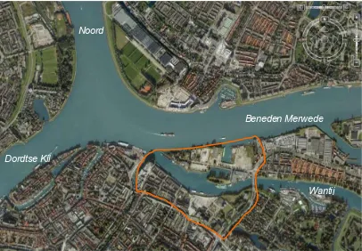
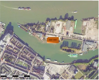
The ground levels within these unprotected areas are relatively high. In the Stadswerven the average elevation is approximately NAP +3m or higher. Only the grounds around the harbour in the old city lie at approximately NAP +2 à 2.5m, making this area more prone to flooding. But the buildings around the harbour are adjusted to be able to cope with flooding. For many of these houses the floor level lies 0.2 – 0.4 m above the ground level, they are floored with tiles and are built such that they are able to withstand water flowing along the outer wall. Figure 2.4 shows a detailed aerial photo of the study area Stadswerven.
Figure 2.4 Aerial photo of the Stadswerven case area (Google earth)
Beneden Merwede Noord
Dordtse Kil
The rivers around the Island of Dordrecht
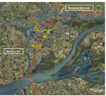
The island of Dordrecht is enclosed by rivers. Clockwise starting at the north side, the island is bounded by the ‘Beneden Merwede’, ‘Nieuwe Merwede’, ‘Amer’ and ‘Dordtse Kil’ (Figure 2.5).
Figure 2.5 Island of Dordrecht. The city of Dordrecht is indicated in yellow. The green line shows the location of the primary dike. The study area Stadswerven is situated within the encircled area.
Dordrecht lies in the transition zone where the water levels are determined by both the discharge of the rivers Rhine and Meuse and the sea levels. The sea influence is also noticed by the fact that the river levels follow the tide cycle.
Figure 2.6 Rivers Rhine and Meuse. Island of Dordrecht is indicated in red. Amer
Nieuwe Merwede Beneden Merwede
Dordtse Kil
The flow direction depends on the discharge of the Rhine and (to a lesser extent) the Meuse. The water flows towards the sea during low tides. Water flows into the sea via the Nieuwe Waterweg (Maasmonding) and through the locks in the Haringvliet (Figure 2.7). The Maasmonding is an open outlet. The discharge at the Haringvliet locks depends on the Rhine discharge at Lobith. The locks are shut when the river discharge is low (< 1200 m3/s). The locks are fully open at a Rhine discharge of 10,000 m3/s.
Figure 2.7 Flow direction during low tides.
The water flow in an opposite direction during high tides up to a Rhine discharge at Lobith of 4000 m3/s as illustrated in Figure 2.8.
Figure 2.8 Flow direction during high tides for a Rhine discharge at Lobith up to 4000 m3/s.
Maasmonding
The flow direction changes when the Rhine discharge at Lobith is larger than 4000 m3/s. From this point onwards the river discharge starts to dominate the incoming tide flow. This is illustrated in Figure 2.9.
Figure 2.9 Flow direction during high tides for a Rhine discharge at Lobith larges than 4000 m3/s
3
Design conditions for flood proof urban
development
An important project goal was to develop design concepts for flood proof urban development through an inter-disciplinary process which involved both water and urban planning experts. By learning through practice, it was possible to gain an insight into which water system parameters are essential or useful within this inter-disciplinary design process. In the initial phase of the design process, flood characteristics were implemented as design conditions. During the process additional information was submitted. The selection of relevant parameters came about through expert judgment from the water experts as well as through questions from the urban planners. This chapter treats the water system parameters which proved to be essential or useful, both as initial design condition as well as during the design process. The evaluated water system parameters are listed in Table 3.1.
Table 3.1 Water system parameters and their relevance for the urban flood proof design
Water system parameter Relevance for urban flood proof design
Water levels, average and maximum water levels under flood conditions. Both the present situation as well as water levels due to climate change have been taken into consideration
Choice of building concepts and public area architecture
Anticipation within design on changing water levels due to climate change.
Anticipation within design on uncertainty. Duration of flooding Choice of building concepts and public
area architecture in relation to possible damage.
Predictability of floods Choice for building concepts and evacuation strategy in relation to safety. Average velocity of the main channels Insight in safety aspects when building
along a river. Maximum reached water depth in the
flooded areas
Choice of building concepts and public area architecture in relation to safety and possible damage.
Water velocities in the flooded areas Choice of building concepts and public area architecture in relation to safety and possible damage.
The effect of the orientation of buildings on the flood pattern
Choice of building concepts in relation to possible damage.
evaluated, but not applied as design condition. The results are treated in chapter 5. The parameters listed in Table 3.1 are discussed in the following paragraphs.
3.1 Water levels
For the urban development of an area not protected by dikes or other defence systems, it is essential to understand which water levels can occur in advance of the design phase. A robust design anticipates on the possible water levels including expected water levels due to climate change. Ground levels and the expected water levels determine the choice for building concepts and public area architecture. A low area subject to frequent flooding calls for different building concepts than an elevated area which will flood only occasionally.
When considering water levels and urban planning, a distinction is made between the regular daily water levels and the less frequent high water levels. The Stadswerven development should be able to cope with the high water levels but should also provide a pleasant and safe environment for daily life. These requirements apply to the present-day situation as well as to future conditions which are subject to climate change. The following sections therefore consider the regular water levels, as well as the extreme conditions. Both aspects are looked at in perspective of climate change.
3.1.1 Present water levels under regular conditions
The water levels at Dordrecht in a regular situation are mainly influenced by the sea tides. Therefore two average water levels are distinguished, an average low and an average high tide water level. The average low tide level at Dordrecht is NAP +0.20m. The average high tide level is NAP +0.90m.
Figure 3.1 Effect of sea level rise on the average water levels along the Rhine river under average discharge conditions. Several values for sea level rise are shown in different colours. The dashed lines indicate the average low tide, the solid lines indicate the average high tide. Dordrecht is at km 980.
Figure 3.1 shows that the average water levels at Dordrecht will increase due to rising sea levels. To which extent the levels will increase, depends on the degree of sea level rise. The relation between the increase of average water levels at Dordrecht and the mean sea level rise, is illustrates in Figure 3.2.
Current sea levels sea level rise of 1 m sea level rise of 2 m sea level rise of 4 m sea level rise of 6 m
Water level (cm +NAP)
Water levels along the Bovenrijn, Waal, Beneden Merwede and Oude Maas – average discharge
Figure 3.2 Relation between increase of average water levels at Dordrecht and the sea level rising due to climate change. The average high tide water level is denoted by the dashed line, the average low tide level by the solid line.
The present low and high tide levels at Dordrecht are plotted at a sea level rise of 0 metre. From Figure 3.1 it can the be seen that an average sea level rise of one meter, results in a water level rise at Dordrecht of approximately 95 centimetre. With this rule of thumb an approximate increase of the average water levels at Dordrecht due to sea level rise is calculated for the different WB21 climate change scenario’s (Table 3.2). see Appendix A for more information on the WB21 climate change scenarios.
Table 3.2 Approximate increase of water levels at Dordrecht due to sea level rise for the three WB21 climate scenarios.
WB21 scenario (KNMI) 2050 2100
minimum 9 cm 19 cm
average 24 cm 57 cm
maximum 43 cm 105 cm
3.1.2 High water levels
Under extreme conditions, the water levels at Dordrecht can reach high values. Although these conditions don’t occur often, urban planners need to anticipate on extreme water levels. Through statistical analysis (frequency analysis), estimations are made of the probability of certain water levels to occur. This probability is expressed as the frequency per year that a certain water level is exceeded, the so-called ‘frequency of exceedance’. The frequency of exceedance is presented on a scale of 0 to 1. The inverse of this frequency is called the return period. A return period indicates on average how often a certain water level is exceeded. A return period of 10 years implies
Sea level rise (m) Water
levels at Dordrecht (m +NAP)
that on average the water level is exceeded once every ten years. It is common practice to first set an acceptable return period, and then find the corresponding water level.
The water level varies per location along the river. Because the variation of the water level is limited within a range of half a kilometre, one representative location was selected for which the water level analysis was performed. The calculated water levels at this point represent the predicted water levels for the whole Stadswerven area.
Figure 3.3 Extreme water level analysis location (arrow) and study area Stadswerven (box).
Extreme water levels at Dordrecht are caused by a combination of factors: - River Rhine discharge
- River Meuse discharge - Sea levels
- Wind speed - Wind direction
- The operation of the Maeslant- en Hartel flood defences (open, closed, failure) - The predictions of the sea levels at Hoek van Holland. These determine the flood
defence operation.
- The operation of the Haringvliet locks
The performed frequency analysis of the water levels at Dordrecht takes all factors except the operation of the Haringvliet locks into account. The probability of an extreme water level at Dordrecht due to either an extreme sea level or an extreme river discharge is extremely small. The statistical analysis therefore considers combinations of either an extreme sea level and a moderately high river discharge, or an extreme river discharge in combination with a moderately high sea level. For the remaining
factors more or less normal values are taken into account. More information on the statistical analysis is given in Appendix A.
The results of the frequency analysis are illustrated in
Table 3.3. The table shows the return periods for the different water levels at Stadswerven. Figure 3.4 illustrates the values in a graph.
Table 3.3 Water levels for different return period at Dordrecht, Stadswerven
Return period
The Flood Management Legislation prescribes that the dikes around Dordrecht should be able to withstand the maximum water level that is expected to occur every 2000 years. This means that the dikes around the island of Dordrecht are designed to be able to avert floods up to a water level of NAP +3.01m. This water level is called the design water level.
3.1.3 Changing water levels due to climate change
It is expected that due to climate change, extreme water levels at Dordrecht will occur more often. This is a result of sea level rise and an expected increase of extreme river discharges (though the average river discharges are not expected to rise due to expected increase of dry spells in summer). Both these factors influence the water levels at Dordrecht. As a consequence the water levels for a given return period will increase. This effect is outlined in Table 3.4. The results are based on the WB21 average climate scenario. This scenario assumes a moderate climate effect.
Table 3.4 Future water levels (m +NAP) based on the WB21 average climate scenario.
return period
average scenario WB21
1 10 100 1000 10000 100000
return period (year)
Figure 3.5 Return period for water levels in 2001, 2050 and 2100.
For the determination of the height of dikes, wave dynamics, seiches e.g. are taken into account by adding approximately 50 cm. to the design water level. The ground levels of Stadswerven are NAP +3m or higher. If 50 centimetres is taken as a measure for the influence of wave dynamics and seiches, it can be expected that on average slight flooding can be expected once every 50 years in the present situation. In future the frequency of flooding will increase considerable. The old city of Dordrecht, which lies at a level of NAP +2 to +2.5 m already experiences occasional flooding events. In future these events will occur more often.
3.1.4 General uncertainty
The given return periods are estimated values. It is possible to determine a confidence interval for these values, considering a number of uncertainties in the calculation method. For the development of the urban designs an indication of the confidence interval is needed. Certain design concepts assume frequent flooding of specific areas. E.g. if houses designed to float during a flood are implemented, then it will be expected that these houses will float on a regularly basis. It is necessary to design the areas assigned for this type of housing at a proper elevation taking the confidence interval into account to assure the flooding of the area. This requires that the return period confidence interval is known. The confidence interval can also be used to determine the necessary flexibility of the design. The uncertainty for short term predictions is smaller than for long term predictions. A flexible design concept anticipates on the long term uncertainty by reserving room for adaptation within the design.
Uncertainties in the calculations are mainly caused by the following factors:
years). The observation period starts in 1970 when the Haringvliet locks were taken into use. Earlier observations are not usable as a result of the altered hydraulic conditions due to the closing of the Haringvliet. In the lower water level ranges more observation points are available which reduces the uncertainty. In the higher water level range, the uncertainty is larger due to the limited amount of observations. In the extreme range where no observations are available, it is necessary to extrapolate the function line resulting in an increase of the uncertainty (see Figure 3.6).
2 Even if it were possible to determine the frequency of exceedance of a certain water level perfectly, it is not certain that this water level will actually be reached within the given return period. The frequency of exceedance is the average or expected frequency. To draw a parallel with the throwing of a dice: although the probability of dicing a three is 1/6, it is not said that when throwing six times, a three will be thrown exactly once. However we can calculate the probability of at least one three in six throws, or no three at all.
3 The uncertainty in development of climate change processes. It is not possible to incorporate the uncertainty due to climate change in the confidence interval. Instead, the uncertainty due to climate change is evaluated through several climate change scenario’s (see paragraph 3.1.5).
The first two types of uncertainty are included in the confidence interval shown in Figure 3.6. The graph is based on observations made in the period 1970 - 2007. It is expected that when applying additional measurements and physical knowledge, the uncertainty range will be smaller. Therefore no extrapolation beyond a return period of 250 years was done.
1 10 100 1000 10000
return period (years)
Figure 3.6 Estimated 95% uncertainty interval (outer lines) based on a limited number of observations (red dots).
3.1.5 Uncertainty due to climate change
are available; the minimum and maximum scenario. These scenarios assume respectively a small and extreme climate change effect (see Appendix A). For the maximum scenario the shift in water levels was calculated. This situation illustrates the ‘maximum effect’ of climate change on the water levels. The current situation illustrates the ‘no effect’ situation. Together they form the minimum and maximum expected effect due to climate change. Figure 3.7 and Figure 3.8 illustrate the uncertainty in water levels according to the climate change scenarios for 2050 and 2100.
2050
Figure 3.7 Average scenario (top solid line) and maximum scenario (dashed line) for 2050. The lower solid line with observation points in red, represents the present situation.
2100
The water levels increase as a result of sea level rise and increase of high river discharges. It is assumed that the confidence interval does not change in the future. The National Federal agreement on water (Nationaal bestuursakkoord Water, 2003) states that for area development at a minimum the WB21 average scenario for 2050 should be considered. For long term planning (time horizon of 200 year or more) it is advised to apply the maximum scenario to be certain of a robust development.
3.2 Flood duration
The impact of a flood is partly determined by its duration. If an area is flooded for a long period, a greater disturbance of daily life can be expected. If, in addition, the water depth is large, extensive damage to buildings and public space can occur. Building in an area which will be flooded often and for longer periods of time, requires a different planning concept than an area which only floods occasionally and for short periods of time.
The duration of a flood peak caused by extreme river discharges, is mainly determined by the duration of the discharge wave. The duration of a flood peak caused by extreme sea levels, is mainly determined by the duration of the storm surge. In Dordrecht, flooding will occur as a result of a combination of river discharge and storm surge. The flood duration is therefore determined by the duration of the storm surge.
An average storm surge duration lies in the order of 30 hours. The duration of a flood on the Rhine or Meuse is about 3 to 4 weeks. But the actual time that the maximum water level is reached, and thus that the Stadswerven area is flooded, is small. The design flood wave causing a water level of NAP +3.01m at Dordrecht will hold at the very maximum for only half an hour after which the water levels will start to lower. This is due to the fact that extreme water levels are only reached by a combination of river discharge and storm surge. From the calculations made with the overland flow (2D) model, it is seen that the flooding of Stadswerven had duration of approximately 8 hours.
Figure 3.9 Location of measurement points
Figure 3.10 Water levels for 3 locations along the Benden Merwede. Rhine river discharge at Lobith is 10000 m3/s, maximum sea level at the Maasmond is NAP +2.96m.
N37
N38
Figure 3.11 Water levels for 3 locations along the Benden Merwede. . Rhine river discharge at Lobith is 2100 m3/s, maximum sea level at the Maasmond is NAP +4.73m.
The difference in flood duration due to a river discharge or storm surge dominated flood is clearly seen for location N38. The locations N37 and N34 show a slight increase of the water levels due to dominating river discharge, but the duration of the flood is relatively short. For the locations N34 and N37 it is seen that the influence of the storm surge is greater than the influence of the river discharge. The figure clearly illustrates the location of Stadswerven (N37) in the transition zone between river and sea dominated water levels.
3.3 Prediction of floods
How far ahead can a flood at Dordrecht be predicted? If the prediction time and thus the warning time is small, there will be little time to evacuate people. In that case it will be necessary to construct for example safe locations within the urban design. On the other hand, if the prediction time is large, there will be enough time to evacuate and evacuation possibilities should be included in the plan.
The predictability of floods at Dordrecht depends on the predictability of a river flood or a storm surge. River dominated floods can be foreseen within a time span of at least 5 days. This is due to the location of Dordrecht at the lower end of both the Rhine and Meuse catchments. With a considerable accuracy a storm surge can only be foreseen twelve hours ahead. The accuracy of the predictions for a larger time span decrease considerably.
3.4 Average flow velocity main channels
Information on the water velocities in the main rivers around Dordrecht is gathered through the measuring program of Rijkswaterstaat. The measuring points of interest for Dordrecht are ‘Dordrecht’ (Beneden-Merwede) and ‘’s Gravendeel’ (Dordtse Kil). The measuring points are illustrated in Figure 3.12. No information on water velocities is readily available for The Wantij. To gain an indication of velocities on the Wantij, use was made of the 1D SOBEK simulation model (see Appendix B).
Figure 3.12 Location of relevant measuring points Rijkswaterstaat
Under influence of the tide, the water flows in two directions. The magnitude of the water velocity and duration of the low and high tide flows, depend on the intrusion of the tide, the discharge of the Rhine and Meuse and the regime of the Haringvliet locks. The duration of the outgoing flow increases with an increasing river discharge and for certain parts of the river at a certain level of river discharge, only an outgoing flow occurs.
Dordtse Kil
Table 3.5 Maximum water velocity (m/s) main rivers at Dordrecht for several Rhine discharges
Dordrecht (Beneden Merwede)
0.31 - 0.19 0.56 - 0.12 0.90 0.46 ’s Gravendeel (Dordse Kil) 0.70 - 0.78 0.71 - 0.80 0.16 - 1.03
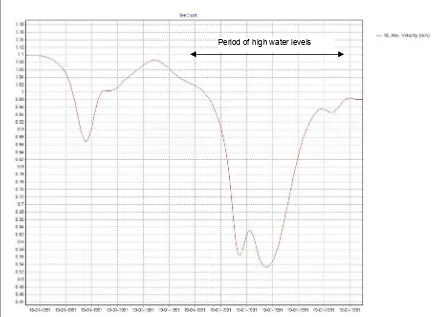
At Dordrecht it is seen that from a Rhine discharge at Lobith of approximately 4000 m3 the direction of flow is in the direction of the sea even during high tides. The velocity during low tides increases when the river discharge increases. The velocities do not exceed 1 m/s up to a river discharge of 6000 m3 at Lobith. From the 1D model results it is seen that the velocities on the Beneden Merwede for higher river discharges could increase to approximately 1.1 m/s.
From the 1D model it is seen that in a situation with extreme water levels, the river velocity decreases considerably. To reach an extreme water level at Dordrecht a combination of high river discharges and a storm surge needs to take place. The opposite directions of the forces caused by the high tide moving inland and the high river discharges moving towards the sea, result in a decrease of the water velocity. This is illustrated in Figure 3.13.
Discharge Rhine at Lobith in m3/s
800 2200 6000
Location: low
tide
high tide
low tide
high tide
low tide
high tide
Figure 3.13 Absolute velocity on the Beneden Merwede during a flood. The maximum water level in the river reaches NAP +3.4m, the predicted design water level for 2100.
The figure shows a decrease in absolute velocity during the flood period. This pattern is seen for all the calculated scenarios.
For the Wantij no measurement data is readily available. To gain an insight into the water velocities which can occur, simulations have been performed using the 1D SOBEK model. Two situations have been evaluated; an average and a high water level situation. For the simulation of the average event, average boundary conditions for both the river discharges and tide were applied. For the high water level simulation, a situation dominated by high river discharges was regarded. In such a situation, the water levels upstream of Dordrecht reach such a height, that the locks at the entrance of the Wantij are flooded resulting in an upstream inflow of water. This in turn results in an increase of the water velocity on the Wantij. The high water simulation evaluated a situation in which a 1:4000 year water level at Dordrecht occurs (NAP +3.10m). The results are shown in Table 3.6.
Table 3.6 Maximum water velocity Wantij (m/s) for an average situation and a high water level situation
Average conditions 1:4000 year extreme flood
Wantij 0.10 – 0.40 +/- 0.9
3.5 Water depths and velocities flooded areas
Figure 3.14 Maximum water depths (m) when the maximum water level in the river reaches NAP +3.1m.
Figure 3.15 Maximum water velocity (m/s) when the maximum water level in the river reaches NAP +3.1m,
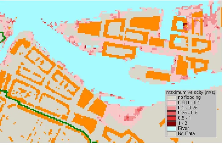
Figure 3.16 Maximum water depths (m) when the maximum water level in the river reaches NAP +3.4m, the predicted design water level for 2100
For a flooding corresponding with a river level of NAP +3.4 m, the entire peninsula becomes flooded. The maximum water depths reach up to 0.75 m. The maximum velocities only exceed 0.25 m/s in a few areas.
From the flooding calculations it can be concluded that the flooding severity of the Stadswerven area is not very high. Maximum water depths and velocities within the study area are relatively low. In the majority of the Stadswerven area, the water depths do not exceed 0.75 metres, and water velocity are below 0.25 m/s. Water forces at these values are low and the situation is safe enough to wade through the water. The restrictions on the application of building concepts and public area architecture is therefore low which provides the possibility for a wide range of building concepts and flood proof sollutions.
3.6 Effect of the orientation of buildings on the flood pattern
The orientation and distance between buildings can have an effect on the flooding patterns. Buildings can act as obstacles causing local water levels to increase or decrease which in turn causes additional forces on a building making a building subject to damage.
The effect of building orientation for the area of Stadswerven is evaluated using a simplified 2D model (a description of the model is given in Appendix B). The largest effect is expected for buildings perpendicular to the flow direction of the water flooding the area, so only calculations were made for this situation. Figure 3.18 shows a view of the situation. The two brown rectangles represent two large buildings. The flow direction of water inundating the area is a resultant of the flow direction in the river and the inland inundation direction. In these calculations the direction of flow has a slight angle to the orientation of the building.
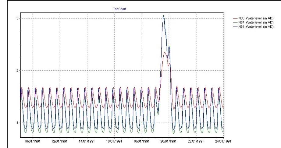
Water levels in front of and behind of the buildings were compared to see if water levels in front of the building rise due to the presence of the building. For the measuring points illustrated in Figure 3.19 the water levels have been plotted in Graph 3.1.
Figure 3.19 Location of measuring points in front of and behind left building.
37, W aterlevel (m AD) 35, W aterlevel (m AD) 36, W aterlevel (m AD) 38, W aterlevel (m AD) TeeChart
20-01-1991 19-01-1991
19-01-1991 19-01-1991
19-01-1991 18-01-1991
18-01-1991 18-01-1991
18-01-1991 3
4
Flood maps for the Stadswerven designs
In Chapter 3 the design conditions for flood proof urban development at Stadswerven were explored. This resulted in three design concepts. One design concept follows a traditional approach which aims at prevention of flooding under all circumstances. The other two concepts explore solutions in which flooding is anticipated on and flood water is even incorporated into the design. For the urban developers reaching a flood proof state is a minimum condition which they need to combine with other requirements for urban development. WP2 only focuses on the water technical aspects.
With the use of the 2D hydraulic model (Appendix B), the design concepts were tested on their ability to withstand a flood. This chapter gives a short description of the design concepts, as well as the results of the 2D simulations. For an extensive report on the development and argumentation of the design concepts one is referred to UFMWP401.
4.1 The design concepts
Mount concept (Terp)
The mount concept follows a traditional approach which aims at prevention of flooding under all circumstances. The ground level for the whole area is raised up to a safe level. Stadswerven is raised up to NAP +4m. This level is in agreement with the design water level predicted for 2100 according to the WB21 climate scenarios. No other measures, such as adjusted building concepts or infrastructure, are applied. This concept provides a safe environment up to the design water level. If the water levels exceed the design level, the area could become flooded.
The Mount concept is applicable in the downstream zone of a river. In other situations (in the upstream zone of a river) this concept will act as an obstruction causing water levels to rise during high river discharges. The Mount concept is therefore not applicable in the upstream zone of a river. An exception can be made for areas which are already high but need to be elevated to comply with changing water levels due to climate change.
For the Mount concept no flooding calculations were made. Due to the elevation of the area no flooding occurs under the conditions as evaluated within the flooding scenarios.
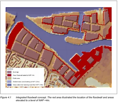
Integrated floodwall concept (Vloedfronten)
Parts of the old city have been subjected to flooding for centuries. In the old centre specific building concepts and public design have been applied to cope with the frequent flooding.
For Stadswerven the defences form a wall which withstands a flood up to the design water level. A large part of the Stadswerven area is protected by the floodwall. The areas not enclosed by the floodwall, are designed to cope with flooding. Optionally within the area protected by the floodwall, additional measures can be taken, such as wet proof housing. This is done to anticipate on a failure of the floodwall.
The Integrated floodwall concept allows the flood water to touch the urban area. By integrating flood defences within the housing and public zone, flooding becomes part of life. The possibility of failure of the floodwall should be taken into consideration though. Figure 4.1 gives a 3-D impression of the integrated floodwall concept for Stadswerven. The red area illustrated the location of the barrier and area’s already elevated to a level of NAP +4m in the present situation.
Figure 4.1 Integrated floodwall concept. The red area illustrated the location of the floodwall and areas
elevated to a level of NAP +4m.
Watersteps concept (Watertreden)
enhancing the quality of the urban environment. The Watersteps concept is orientated around the Wantij river. The ground level in a zone surrounding the Wantij river rises in inland direction. This provides different flooding environments making it possible to implement several flood proof building concepts in a range from wet proof to floating. The remaining area is raised to a safe level to accommodate for vulnerable functions and provide a safe haven when needed. The water is not approached as an element which should be kept out under all circumstances, but instead is integrated into the urban environment.
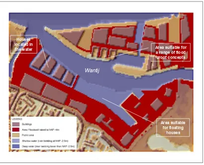
Figure 4.2 gives a 3-D impression of the Watersteps concept applied to Stadswerven. The red area illustrated area which is elevated to a safe level of NAP +4m. Around the Wantij areas are designated for floating houses, houses located in the water creating a Venice like setting and for different types of wet and dry proof building concepts.
Figure 4.2 Watersteps concept. The red area illustrated the area which is elevated to a level of NAP +4m. Around the river Wantij, floating houses are planned. These are not illustrated in the figure.
4.2 Results of the flood simulations of the Stadswerven designs
The following paragraphs treat the results of the flooding simulations for the Integrated floodwall and Watersteps concepts applied for Stadswerven. For the Mount concept, no calculations were made because no flooding will occur due to the elevation of the ground level. The results show maps of the maximum reached water depths and velocities in the flooded area.
Wantij
Area suitable for floating
houses Houses
located in
the water Area suitable for
Flood simulations Integrated floodwall concept
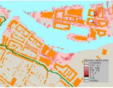
The maximum reached water depths and velocities for the Integrated floodwall design are presented in Figure 4.3 and Figure 4.4.
Figure 4.4 Integrated floodwall concept, maximum reached velocities (m/s) when the maximum water level in the river reaches NAP +3.4m, the predicted design water level for 2100.
The figures show that the areas behind the floodwall do not flood. The outer areas as expected do become flooded. The water depth in these areas can become quite large reaching depths up to 1 to 2 m. Some of these areas are former shipyard slipways. Although the water depth are quite large, the velocities are not very high, mainly within a range up to 0.25 m/s. This provides a safe environment, although it is recommended to evaluate if the water depths are within an acceptable range.
Watersteps concept
Figure 4.5 Watersteps concept, maximum reached depths (m) when the maximum water level in the river reaches NAP +3.4m, the predicted design water level for 2100.
5
Sedimentation and sewage during flooding
5.1 Sedimentation during a flood
When developing a flood proof urban design, not only the aspects which occur during a flood should be taken into consideration, but also the effects of the flooding which arise after the actual flooding. When an area has been flooded, a residue due to sedimentation of clay, silt and garbage is left behind.
To gain an insight in the amount of sedimentation due to flooding in the Stadswerven area, preliminary calculations were conducted. Use was made of the SOBEK overland flow module (2D) in combination with the water quality module. Calculations representing the present situation were performed. This implies the present ground level and implementation of a traditional building layout. The design concepts ‘Integrated floodwall’ and ‘Watersteps’ for the Stadswerven were also evaluated. A flood was simulated which reaches a water level of NAP +3.4m, the predicted design water level for 2100.Because of the limitations in the availability of data of discharges and suspended particle matter (SPM) concentrations, it was decided to perform calculations for two different concentrations of SPM. The sediment loads for scenario 1 are 50 mg SPM/l and for scenario 2, 100 mg SMP/l. An extensive description of the calculations can be found in Appendix C.
The results for the calculations of scenario 2 are shown in Figure 5.1 to Figure 5.3. The figures show the thickness of the sediment layer (m) resulting from the flood event.
Figure 5.2 Thickness of the sediment layer (m) for design concept Integrated floodwall.
Figure 5.3 Thickness of the sediment layer (m) for design concept Watersteps.
The results show that for the Stadswerven area only a thin layer of sedimentation, in most areas not more than 1 mm, is deposited. This is due to the fact that the area is only flooded for a short period. It is seen that the layer of sedimentation is slightly thicker for the Watersteps design. This is mainly seen in the areas where the water depths are larger and can be accounted to the fact that the deeper areas are flooded for a longer period of time. Thicker layers of sediment also accumulate on the southern shore of the Stadswerven area at the mouth of the Wantij river.
During periods of low flow, SPM concentrations are low, but a lot of sources still introduce contaminants in the river system. Therefore, SPM quality can be poor. From research it is seen that during periods of high river flow, SPM concentrations increase and SPM quality can improve. This is attributed to dilution of the SPM with clean sediment material from the surrounding area (Asselman (2003), and Van der Heijdt and Zwolsman (1997)).
For areas which flood more frequently one should anticipate on the possibility of deposition of contaminated sediments. Each flooding event leaves a thin film of residue which could accumulate over time and become a thicker layer.
5.2 Effect of a flood on the sewage system
Sewage systems have not been designed to cope with floods. Therefore it can be expected that during a flood, contaminated sewage water will mix with flooding water. For sanitary reasons this is not desired.
6
Assessment criteria for flood proof development
6.1 Assessing flood proof urban developments
A flood proof urban development is achieved by implementing different design concepts and technical solutions. But under which conditions is an urban development actually flood proof? This depends on the set objective for the area which in turn depends on the characteristics of an area. From the experience gained with the case study Stadswerven, a simple method for assessing urban designs aiming at flood proofness was developed. The method is illustrated in Figure 6.1.
Figure 6.1 Flow chart for assessing urban designs on flood proof aspects.
For the assessment of urban designs, a goal is set to which the design should conform. It is necessary to choose a realistic goal in accordance to the area characteristics. For an area with an expected water depth of 4 meters, it is not realistic to implement a flood proof design aiming at minimal disturbance of daily life. Next, criteria are defined by which a design can be assessed, for instance a safety level or the presence of safe havens. These criteria should be in accordance to the set goal. If a design does not conform to the set criteria, it will be necessary to question the feasibility of the goal and/or the set of criteria.
Setting flood proof goals
When considering flood proof targets, it is seen that in general three target levels can be distinguished:
1. No casualties, 2. and limited damage,
3. and minimal disruption of daily life.
With each level the targets are set higher than the previous level. The first level tackles the safety aspects. Level 2 incorporates the prevention of damage loss due to flooding. For level 3 the goals are set the highest by only allowing minimum disruption of daily life.
Area specific flood characteristics
When defining flood proof targets for an urban development, one is dependant on the characteristics of an area. In an area where the flooding depth reaches 5 meters, it will be almost impossible to develop the area such that minimum disturbance of daily life is accomplished. The ‘Ruimtelijk Plan Bureau’ (Pols, 2007) classifies an area by two flooding characteristics; the rate at which an area becomes flooded and the maximum flooding depth. This results in four classes of risk zones (Figure 6.2).
Figure 6.2 Risk zones by flooding rate and depth
According to Pols it is advised to implement adjusted building concepts in areas where small flooding depths are expected in combination with rapid flooding which leaves no time to evacuate (risk zone 2). The adjusted building concepts provide a safe shelter for people within the flooded area. It is questioned though by others if it is cost effective to use adjusted building concepts in areas where the probability of flooding is very low. If the expected water depths are small, and the rate of flooding is low as well (risk zone 4), enough time is available to evacuate. Therefore no additional measures are suggested unless the area will be used to shelter people from more seriously struck areas.
When looking at the areas where significant flooding depth are to be expected, it is seen that adjusted building concepts are not applicable (risk zones 1 and 3).
In areas where the flooding rate is low (risk zone 3), the focus will need to be on adequate evacuation planning including adequate evacuation routes. For the remaining areas (risk zone 1) with a rapid flood rate, it is even recommended to prevent urban development. In this cases it is advised though to also take the predictability of a flood (lead time) into consideration. If the lead time is large enough, enough time will be available to evacuate the area.
The risk zones 1 and 3 aim at preventing casualties (level 1). Areas which are of type ‘risk zone 2’, target at preventing damages and even at a minimal disruption of daily life. It should be kept in mind though that the choice to implement adjusted building concepts will also depend on cost effectiveness criteria.
The RPB methodology only considers the water depths and rate at which an area is flooded. This method provides a practical way to classify flooding areas. If required, other characteristics can be taken into account to characterise an area such as the probability of a flood, the predictability of a flood (lead time), water velocities, drainage time etc.
Criteria
A checklist with criteria was developed which can be used to assess a flood proof urban development and aid in testing if the flood proof goals have been reached (Table 6.1). The checklist should be seen as an outline on how to test an urban development. These criteria were developed from the experience with the Stadswerven case study and focus on the water related aspects relevant for areas unprotected by dikes. It provides an onset and can be extended if necessary e.g. with non water related criteria.
Table 6.1 Water related criteria for evaluation of flood proof urban design based on the Stadswerven case.
Target level
Criterion Explanation Water related
parameter Safety level Design water levels indicate a
desired safety level. A flood proof urban design should be able to provide safety up to this safety level.
Strong currents and deep water do not provide a safe
environment. A design should therefore be tested on these parameters.
Due to climate change, it is expected that the frequency of high river discharges will
increase. A sea level rise is also foreseen. These aspects result in increased water levels. A flood proof urban design should therefore take climate change
into consideration.
Strength buildings Strong currents, deeper water, waves and duration of flooding can cause buildings to be damaged up to collapsing.
Not only the safety during a flood should be taken into consideration, but also the safety during daily life.
River velocity
Safe havens within area
People can be taken by surprise by rapidly rising waters. shelters within an area depends among others on the
In areas where the overland velocity of water is moderate to high, the water velocities in the streets can increase due to the distance between buildings. Measures can be taken for instance by increasing the width or layout of the street.
Water velocities
Effect on other areas
Changing water patterns in one area, can have an impact on the water patterns in another area. This should be taken into consideration.
All technical measures have a possibility of failing. Failing could result in an uncontrolled flooding situation.
In areas where the overland velocity of water is moderate to high, the forces of the water and water depth can increase due to
dangerous levels the orientation of the buildings compared to the flow direction. Incorporation of
flood proof infrastructure
For evacuation, emergency services as well as use for daily life activities.
If areas are designed to flood frequently and sedimentation levels are high, this can cause unwanted residues in public
The electricity network will be damaged if it comes into contact with water. This can be
prevented by locating electricity outlet points and sockets on a safe level. a design. Some areas are lowered to provide frequent flooding. Others are elevated to prevent flooding. The ground levels for these areas depend on the water levels and on the confidence interval of the water levels.
Controlled flooding The advantage of flood proof building, is that flooding can occur in a controlled manner. To what extent do the design concepts provide control over the flooding?
3
Flood proof sewage system
It is seen that the aspects for which hydraulic input is needed, are mainly focussed on the safety aspects (target level 1). Other aspects, e.g. fresh water supply under flooding conditions, attractiveness of the design, flexibility to adapt to changing circumstances, cost effectiveness etc. are aspects to be considered by other disciplines.
6.2 Evaluation of the Stadswerven designs
The Stadswerven area can be characterised as type ‘risk zone 2’. When the river exceeds a certain water level, the area is almost immediately flooded, although the water depths are small, the duration of flooding is short and the water velocities are relatively low (< 0.25 m/s, a velocity at which wading through the water is still safe). These favourable circumstances make it possible to set an ambitious target, aiming at minimal disruption of daily life.
The Stadswerven concepts were evaluated using a selection of the criteria from Table 6.1. The evaluation focuses on the stronger and weaker points of the different concepts and provides a way to compare the concepts. The choice of criteria was based on the relevance for Stadswerven, on the availability of calculation results to argue the criteria and on the aspects in which the concepts are distinguishing.
Table 6.2 Evaluation of the Stadswerven concepts
Mount Integrated floodwall
Watersteps
Safety level + + +
Maximum reached velocities and depths are
within safety limits + + +
Anticipation on climate change + + +
Safety river under average conditions + + +
Safe havens within area + - +
Anticipation on possible failure of floodwall +
Incorporation of flood proof infrastructure + +
Controlled flooding - +
All aspects are assessed for a water level up to3.4m +NAP, the foreseen design water level for 2100.
: Not applicable to the design concept + : complies with the criterion
- : does not comply with the criterion
All concepts are designed such that they comply with the safety aspects. The concepts prescribe a safe infrastructure network called a lifeline. The integrated floodwall design for Stadswerven does not incorporate safe havens in the northern area, but this area is connected by this lifeline to the main land where higher grounds are situated.
If the water levels exceed the design level, the area could become flooded. No anticipation to flooding is incorporated in the design, resulting in an uncontrolled flooding. This also applies to the higher grounds within the other two design concepts. For the Integrated floodwall concept it should be taken into account that there is a possibility of failure of the floodwall. A failure can cause flooding effects similar to the breaching of a dike. The design concept leaves room for adjusted building concepts in the area behind the floodwall.
The Watersteps concepts comply with all criteria. The concept anticipates on flooding. Water is welcomed within the area adding to the attractiveness of the sight.