POTENSI KERAWANAN GELOMBANG TSUNAMI DI PESISIR BANTUL,
DAERAH ISTIMEWA YOGYAKARTA
Rahadimas Giyan Setyadi
*), Denny Nugroho S
*), Subandono Diposaptono
*), Widjo Kongko
*)*) Jurusan Ilmu Kelautan, Fakultas Perikanan dan Ilmu Kelautan
Email :
subandono.diposaptono@yahoo.com
Abstrak
Bantul merupakan salah satu daerah yang berada tepat di hamparan Samudera Hindia pada selatan Pulau Jawa dengan pergerakan lempeng yang cukup implusif sehingga sering terjadi gempa bahkan tidak menutup kemungkinan rawan terjadi gelombang tsunami. Tujuan dari penelitian ini untuk menentukan potensi kerawanan yang ditimbulkan gelombang tsunami di pesisir Bantul, Daerah Istimewa Yogyakarta yang diolah menggunakan persamaan Green Law dan Global Mapper 13. Data yang digunakan dalam penelitian ini meliputi data slope (kelerengan pantai), data elevasi pantai, data koordinat penelitian, data bathimetri, data
source (sumber gempa bumi), dan data pasang surut. Hasil dari parameter yang menjadi potensi kerawanan
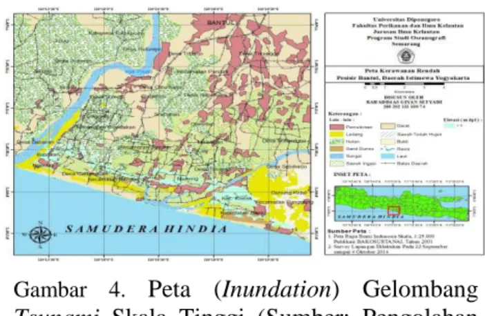
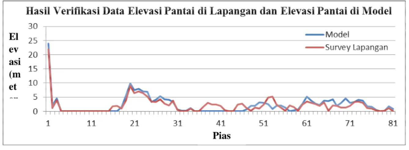
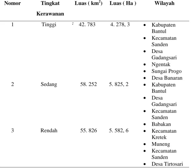
gelombang tsunami yaitu jarak dari garis pantai 2 km, jarak dari sungai 100 meter, potensi kerawanan tinggi, sedang, dan rendah dari parameter elevasi pantai sebesar (< 1 meter, 1 – 3 meter, dan > 3 meter), slope atau kelerengan pantai tertinggi dan terendah secara berturut – turut adalah (14, 91 % dan -0, 0006 %). Total luas daerah yang terimbas akibat kerawanan gelombang tsunami yaitu 156, 861 km2 atau 15. 686, 1 Ha. Dan total daerah yang memiliki potensi kerawanan gelombang tsunami sebanyak 10 daerah yang tersebar di pesisir Bantul, Daerah Istimewa Yogyakarta.
Kata Kunci: Gelombang tsunami; Global Mapper 13; Potensi Kerawanan;Green Law;Bantul.
Abstract
Bantul are one area which is right in the expanse of the Indian Ocean on the southern island of Java with plate movement implusif enough so that frequent earthquakes not even rule out the possibility prone to tsunamis. The purpose of this study was to determine the potential vulnerability caused tsunami in the coastal Bantul, Yogyakarta is processed using equations Green Law and Global Mapper 13. The data used in this study includes data slope (slope beach), beach elevation data, coordinate data research, the data bathymetry, the data source (the source of the earthquake), and tide gauge data. Results of the parameters which are a potential vulnerability tsunami wave that is the distance from the coastline 2 km, distance from the river 100 meters, vulnerability of high, medium, and low elevation of the parameters of the coast (<1 meter, 1-3 meters, and> 3 meters ), slope or beach slope the highest and lowest, respectively are respectively (14, 91% and -0, 0006%). Total area affected due to insecurity tsunami that is 156, 861 km2 or 15 686,1 Ha. And the total area which has the potential vulnerability tsunami wave of 10 sites spread across the coastal Bantul, Yogyakarta.