PERPUSTAKAAN UMP
1111111111111111111111111111111111111111111111
0000072552
A STUDY ON CAUSES OF FLOOD AT SUNGAI ISAP AND JALAN TUN ISMAIL, KUANTAN, PAHANG
AINATUL SHAHIRAH BINTI MOJID SARU
Report submitted in partial fulfillment of the requirements for the award of Bachelor of Civil Engineering
Faculty of Civil Engineering and Earth Resources UN!VERSITI MALAYSIA PAHANG
PEPUSTAKAAN7iT UNIVERSm MALAYSIA PAHANG
No, Peroehari No. PangUan
072552
Tarikh * 2 9 MAR 2013ABSTRACT
Sungai Isap of Kuantan, Pahang is located in a flood prone area. The largest flood was occurred on the late December 2001 caused inundation on the entire residential area. While on December 2011, flood has occurred at Jalan Tun Ismail which is the area does not normally experiences flood. The research is focused on finding the causes of flood in both areas hence the findings are compared to identify the potential similarities between the causes of these two events. This paper also examined the community's level of awareness toward floods and the effectiveness of flood warning systems implemented by authorities. The primary data were obtained through distribution of questionnaire to 200 respondents, and the data were strengthening by interviewing the local communities who were randomly selected along with the relevant parties which are related with flood matters. Participatory Statistically Program for Social Study (SPSS) was applied to analyze the data obtained through questionnaires. The occurrence of these floods cannot be attributed only to natural causes of heavy precipitations and tidal action. A combination of human activities in developing the areas which is resulting in increasing number of the impervious land, provide inadequate drainage systems and the choice of humans to occupy the hazardous floodplains has exacerbated the incidence of flooding when associated with natural causes. It is observed that the level of awareness of respondent towards their ability as community to limit the impact of floods did differ across their locations, with greater awareness of respondent in locations of Sungai Isap than among respondent at Jalan Tun Ismail. Communities also demanded the authorities to enhance the effectiveness of flood warning to reduce flood risk. Strengthening and raising public awareness is necessary as community knowledge is very important to improve preparedness and mitigation to reduce impact due to flood.
ABSTRAK
Sungai Isap, Kuantan, Pahang merupakan kawasan yang kerap dilanda banjir. Banjir paling buruk berlaku pada akhir Disember 2001, menyebabkan keseluruhan kawasan perumahan ditenggelami air. Pada Disember 2011, banjir kilat berlaku di Jalan Tun Ismail yang mana kawasan berkenaan bukanlah kawasan yang biasa dilanda banjir. Kajian mi memberi tumpuan kepada punca banjir di kedua-dua tempat. Hasil kajian dibandingkan untuk mengenalpasti kebarangkalian terdapatnya persamaan diantara kedua-dua kejadian. Penilaian terhadap tahap kesedaran masyarakat terhadap banjir dan juga keberkesanan amaran banjir yang dilaksanakan oleh pihak berkuasa turut dijalankan. Data primer diperoleh dengan mengedarkan borang soal selidik terhadap 200 orang responden. Data diperkukuh dengan menemubual beberapa penduduk tempatan yang dipilih secara rawak serta pihak yang berkaitan dengan banjir. Perisian Statistically Program for Social Study (SPSS) digunakan dalam penganalisisan data. Kejadian banjir dikedua —dua tempat mi tidak dipengaruhi faktor semulajadi semata-mata iaitu hujan lebat dan tindakan pasang surut. Kombinasi aktiviti manusia dalam membangunkan kawasan berkenaan meningkatkan kawasan tidak telap air,penggunaan sistem longkang yang tidak efisien dan pemilihan manusia untuk menduduki kawasan dataran banjir yang berisiko memburukkan lagi permasalahan banjir apabila digabungkan dengan faktor semulajadi. Dapatan daripada kajian menunjukkan tahap kesedaran responden berbeza mengikut lokasi, dengan tahap kesedaran yang lebih tinggi dalam kalangan masyarakat di Sungai Isap berbanding masyarakat di Jalan Tun Ismail. Masyarakat berharap pihak berkuasa akan meningkatkan keberkesanan sistem amaran banjir bagi mengurangkan risiko banjir. Pengukuhan dan peningkatan kesedaran dalam kalangan masyarakat adalah perlu kerana pengetahuan masyarakat sangat penting untuk meningkatkan kesiapsediaan bagi mengurangkan impak banjir.
TABLE OF CONTENTS
Page
SUPERVISOR'S DECLARATION ii
STUDENT'S DECLARATION iii
ACKNOWLEDGEMENTS iv
ABSTRACT ABSTRAK
TABLE OF CONTENTS vii
LIST OF TABLES
LIST OF FIGURES xii
CHAPTER 1 INTRODUCTION 1.1 Introduction 1 1.3 Problem Statement 2 1.3 Objectives 3 1.4 Scope of Study 3 1.5 Significance of Study 5
CHAPTER 2 LITERATURE REVIEW
2.1 Introduction 6 2.2 Definition of Flood 9 2.3 Type of Flood 9 2.3.1 River floods 10 2.3.2 Coastal floods 11 2.3.3 Flash floods 12
2.3.3 Other type of floods 13
2.4 Causes of Flood and Flood Intensifying Factors 14
viii 2.5 Floods in Europe 17 2.6 Floods in Nigeria 18 2.7 Floods in Malaysia 18 2.8 Floods at Sungai Isap
22 2.9 Flash Floods atJalan Tun Ismail
23 2.10 Flood Warning and Flood Awareness
24 2.11 Conclusion
25
CHAPTER 3 RESEARCH METHODOLOGY
3.1 Introduction 26 3.2 Stages of Research 26 3.3 Primary Data 27 3.3.1 Questionnaires 28 3.3.2 Site observation & interviews
30 3.4 Secondary Data 30 3.5 Data Analysis 30 3.6 Conclusion 31
CHAPTER 4 RESULTS AND DISCUSSION 4.1 Introduction 32 4.2 Demographic of Respondent 32 4.2.1 Gender 32 4.2.2 Group of age 34 4.2.3 Highest educational qualification
35 4.3 Causes of Flooding
36 4.4 Awareness Level of the Community
38 4.4.1 Floods are a natural event there is not much we can do
38 about them
4.4.2 There is a lot we can do as community to limit the
39 impacts of floods
4.4.3 Concerned about the risk of flooding
41 4.4.4 Concerned about the flood warnings and or/river heights
42 before the flood
4.4.5 Concerned about assess own situation to be potentially
43 at risk of flood
ix
4.5 Flood Warnings
4.5.1 Early warnings are the key to reduce the impact of floods
4.5.2 The meaning of 'flood warning' message
4.5.3 Satisfaction with the flood warnings issued by authorities
4.5.4 The method of receiving flood warning
4.5.5 Preference method to learn about a flood warning 4.6 Opinions on Flood
4.6.1 The recent floods are a result of climate change 4.6.2 Responsible for flooding & flood related issues, now
and in the future
4.6.3 People should expect their property to be flooded if they choose to live in a flood risk area
4.6.4 Creating more green spaces to absorb water within developments area are as a way to minimize future flood risks
4.6.5 Deepen or widening the river channel are as a way to minimize future flood risks
4.6.6 Updating the drainage systems are as a way to minimize future flood risks
4.6.7 Increasing the awareness towards community are as a way to minimize future flood risks
CHAPTER 5 CONCLUSION AND RECOMMENDATIONS
5.1 Introduction
5.2 Conclusion
5.3 Recommendation
5.3.1 Recommendation for current study 5.3.2 Recommendation for further study
REFERENCES APPENDICES
A Causes of flood from site observations B Questionnaire form 44 45 46 48 49 50 51 51 52 54 55 56 57 59 61 62 62 62 63 64 69 69 71
LIST OF TABLES
Table No. Page
2.1 Data on natural disasters for the period 1975 —2001 7
2.2 The worst-hit areas in 2001 22
4.1 Gender of respondents 33
4.2 Group of age 34
4.3 Highest educational qualification 35
4.4 Perception on the factor most contributing to the flood event 37
4.5 Floods are a natural event there is not much we can do about 39 them
4.6 There is a lot we can do as community to limit the impact of 40 floods
4.7 Chi-Square tests 40
4.8 Concerned about the risk of flooding 41
4.9 Concerned about flood warnings and/or river height before the
43 flood
4.10 Concerned about assess own situation to be potentially at risk of 44 flood
4.11 Early warnings are the key to reduce the impacts of floods
45
4.12 The meaning of 'flood warning' message 47
4.13 Satisfaction with the flood warnings issued by authorities
48
4.14 The method of receiving flood warning 49
4.15 Preference method to learn about a flood warning
51 4.16 The recent floods are a result of climate change
52
xi
4.17 Responsible for flooding & flood related issues, now and in the 53 future
4.18 People should expect their property to be flooded if they choose 54 to live in a flood risk area
4.19 Creating more green spaces to absorb water within developments 55 area are as a way to minimise future flood risks
4.20 Deepen or widening the river channel are as a way to minimise 57 future flood risks
4.21 Updating the drainage systems are as a way to minimise future 58 flood risks
4.22 Increasing the awareness towards community are as a way to 59 minimise future flood risk
LIST OF FIGURES
Figure No. Page
1.1 Map of Sungai Isap's settlement 4
1.2 Map of Jalan Tun Ismail 4
2.1 Causes of floods and flood-intensifying factors 15
2.2 Interactions between the human use system and the natural 19 events systems to produce flood hazards and disasters.
3.1 Stages of Research 27
4.1 Gender of respondents 33
4.2 Group of age 34
4.3 Highest educational qualification 35
4.4 Perception on the factor most contributing to the flood event 38
4.5 Flood plain area 69
4.6 Obstruction in drainage 69
4.7 Improper dumping causes drainage to clog 70
4.8 Development increased the impervious land 70
4.9 Floods are a natural event there is not much we can do about 39 them
4.10 Concerned about the risk of flooding 42
4.11 Concerned about flood warnings and/or river height before the 43 flood
4.12 Concerned about assess own situation to be potentially at risk of 44 flood
4.13 Early warnings are the key to reduce the impacts of floods 46 xl'
xl"
4.14 The meaning of 'flood warning' message 47
4.15 Satisfaction with the flood warnings issued by authorities 48
4.16 The method of receiving flood warning 50
4.17 Preference method to learn about a flood warning 51 4.18 The recent floods are a result of climate change 52
4.19 Responsible for flooding & flood related issues, now and in the 53
future
4.20 People should expect their property to be flooded if they choose 54 to live in a flood risk area
4.21 Creating more green spaces to absorb water within developments 56 area are as a way to minimise future flood risks
4.22 Deepen or widening the river channel are as a way to minimise 57 future flood risks
4.23 Updating the drainage systems are as a way to minimise future 58
flood risks
4.24 Increasing the awareness towards community are as a way to 60 minimise future flood risk
CHAPTER 1
INTRODUCTION
1.1 INTRODUCTION
Floods are a common universal natural phenomena taking place in most parts of the world and it is also destructive from all natural disaster. In Malaysia, flood has always been the major natural catastrophe (Keizrul bin Abdullah, 1999) causing tremendous losses. According to Chan (2002), generally, the losses can be due to tidal floods, monsoon floods, flash floods and it is not impossible resulting from a combination of all three. Albeit heavy monsoon rainfalls have a profound influence in Malaysia (Biswajeet Pradhan, 2009), however, the flood risk is increasing due to rapid urbanization (Chan, 1997). Heavy downpours when combined with the increasing number of impervious lands and poor drainage systems have reduce the amount of water to infiltrating into the ground, thus increase surface run-off (Andras & Chris, 2005), and as the rivers or drainages are not able to endure the sudden water capacity, therefore, the water spills and flood happens.
In many parts of world, monsoon floods are often predictable and generally acceptable as it deposited rich soil thus provide ideal condition for plant growth, supply water and convenient of transport in exchange, however flooding at an unexpected destructive degree causes damage to life and the environment. According to Kurshid Alam (2007), for over the past decades, the pattern of floods has becoming unpredictable and more frequent. Seasonal flood potentially to wreak havoc on unprepared communities, and the increasing occurrence of flash flood in urban area especially in area that does not normally experience floods is quite worrying. Low Kwai
2
Sim & G. Balamurugan (2006) stated that flash flood problems have been considered as a product of rapid, uncontrolled urbanization and unsustainable development.
In Malaysia, there has been many experiments were done particularly in flood risk management for .over the last few decades. However the hard work produced effective results only when they were employed in an integrated manner. According to research carried out by M. Faisal et al. (2000), non-structural measures such as flood forecasting, flood warning, and flood zoning have been identified as vital in flood mitigation by all experts interviewed. Improved flood warning system and individual preparedness are the most effective means of minimizing flood damage, thus shows that the opinions expressed by the general public comparable to the opinions expressed by the expert.
Consequently, as a response to floods that occur along the way, the structural measures should be incorporate with non structural measures in overall development and recovery activities. Even though many programs to reduce intolerable flood is developing over time, floods are a natural event that will continue to occur, therefore, flood awareness is crucial. Chan (2002) stated the public should be more aware to warning system and should be taught to respond effectively as even the most sophisticated warning system would be of little use if the public themselves do not heed the warnings. Various parties including the community should play their roles to provide intrinsic value for comfort which is necessary for human being at large.
1.2 PROBLEM STATEMENT
Floods have reoccurred in some areas in Kuantan, Pahang especially the low-lying land in Sungai Isap. Recently, flood has hits the area of Jalan Tun Ismail on 4 December 2011, which the area itself does not normally experience floods. Due to this, the flood has destroyed a big amount of properties and make the community live in discomfort.
Flood causes by many factors. The occurrence of these floods cannot be attributed only to natural causes. When a flood occurs, it becomes a serious problem
3
because flood may cause damages to crops, properties, public facilities, and others. Besides, loss of life may happen if extreme flood occurs. Therefore, a study needs in order to determine the actual causes hence to reduce the impact of floods in the study areas.
1.3 OBJECTIVES
The objectives of this research are as following:
i. To identify the causes of flood at Sungai Isap and Jalan Tun Ismail.
ii. To determine the potential similarities between the causes of flood at Sungai Isap and Jalan Tun Ismail.
iii. To evaluate the awareness level of community and the effectiveness of flood warning measures issued by authorities to reduce flood risks.
1.4 SCOPE OF STUDY
For the scope of study, the limitation has been done in order to focus and narrow down the topic to the specific area and subject of study. This study will focuses on the causes of flood events in Sungai Isap and Jalan Tun Ismail. This study also concerns on the awareness issues among community and the effectiveness of the flood warnings by authorities in reducing flood risks by measuring the responds from population.
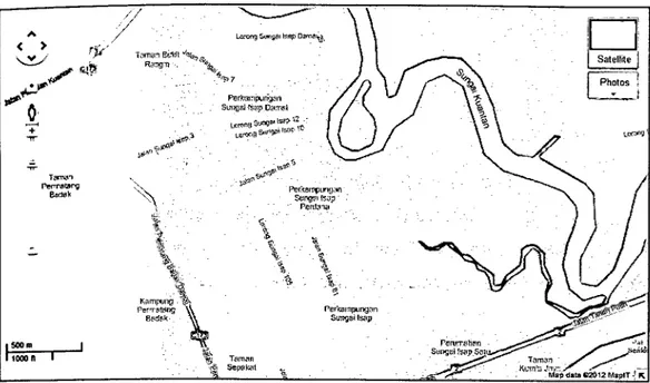
The areas of the case study are concentrated on the area at Sungai Isap (Figure 1.1) and at Jalan Tun Ismail (Figure 1.2), Kuantan, Pahang. Thus the respondent will be the community in the particular areas.
4
A -. L,a o,-9
1 1
<
Teea1 Bit Satellite
• I! •)i'
\_I
-
IVal ft I TmllFigure 1.1: Map of Sungai Isap' s settlement
Source: Google Maps
Satelifte Smoker Center P-1.r V,, C, Ham Lewl -- .9 • eIah - I. - / T __L1 M,pdi2O12Googk. M.ptT
Figure 1.2: Map of Jalan Tun Ismail
5
1.5 SIGNIFICANCE OF STUDY
The significance of this study is to understand about the flood issues and the causes of floods. Therefore, the findings may provide necessary information to the communities in both areas. The study also has been done to understand the type of flood those usually occur in study areas. It also represents the satisfaction level toward flood warnings which is an important aspect in flood management, hence to urge local government to enhance the effectiveness of flood prevention and preparedness countermeasures. In addition, this study also represents the awareness level of the community towards flood issues.
CHAPTER 2
LITERATURE REVIEW
2.1 INTRODUCTION
Water is the crucial element to life. No human, animal or plant will be able to live without water. However excessive water causes havoc and create a terror in the form of floods. The events of floods are responsive to the intricate hydrological system and the aggresive changes caused by continuous human interventions in nature's processes. Throughout the history, floods have the greatest damage potential of all natural disasters across the world and affect the most number of people. Every year, floods washes away everything that comes in its way, destroying crops, livestock, houses and other properties, and it is also dislocate the region's inhabitants. Floods do not cause immediate damage only, but also leave extensive problems that rise during and after the water receded, such as health problems that sometimes come up as epidemics, not to mention, the process to redevelop the affected area take a lot of efforts, and consume a large amount of money and time.
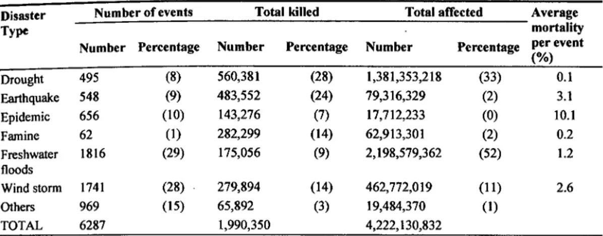
Floods are the most destructive of natural disasters and cause the greatest number of deaths (S. Fattorellj et al., 1999) and it is also are the most common and widespread of all-natural disasters (Bhanumurthy and Behera, 2008). According to the result of study by Jonkman (2005) for period 1975 - 2001, of all recorded natural disasters in the period 1975 - 2001, a total 1816 fresh floods were the most frequently OCcurring. Droughts and earthquakes were the natural disasters killed most persons. While other disasters are more significant with respect to numbers of killed, floods by far affect the most persons which is 2.2 billion persons. These figures indicate the
FA
enormous impacts of flood disasters on a worldwide scale. These results with respect to the distribution of numbers of events and persons killed over the different disaster categories as shown in Table 2.1.
Table 2.1. Data on natural disasters for the period 1975 —2001
Disaster Number of events Total killed Total affected Average
Type mortality
Number Percentage Number Percentage Number Percentage per event
(%) Drought 495 (8) 560,381 (28) 1,381,353,218 (33) 0.1 Earthquake 548 (9) 483,552 (24) 79,316,329 (2) 3.1 Epidemic 656 (10) 143,276 (7) 17,712,233 (0) 10.1 Famine 62 (1) 282,299 (14) 62,913,301 (2) 0.2 Freshwater 1816 (29) 175,056 (9) 2,198,579,362 (52) 1.2 floods Windstorm 1741 (28) 279,894 (14) 462,772,019 (11) 2.6 Others 969 (15) 65,892 (3) 19,484,370 (1) TOTAL 6287 1,990,350 4,222,130,832
Numbers in parentheses denote percentage.
(Source: Jonkman, 2005)
Floods still occur in the future, therefore, people all over the world have learned to adapt with floods. Nevertheless, the communities sometimes are taken completely by surprise when flood happened because they are unaware of what can happen and have no single idea on how to adapt if nature strikes, however, according to Berz (2000), even if people have experienced a disaster themselves, within a few years they tend to forget its lessons. In order to reduce flood risk, it is vital to increase the awareness for flood preparedness. Therefore, the society must move from the current paradigm of Post-disaster response (Elisabetta Genovese, 2006). The occurrence of flood can effortlessly set back decades of investments in infrastructure, thus seriously cripple the economic prosperity, and result in thousands of deaths and epidemics. As flood will continue to occur, societies have to learn fast from the new approaches such as applying experience gained from flood events and mitigation efforts employed elsewhere.
8
2.2 DEFINITION OF FLOOD
Floods are by far the most common natural hazard in causing loss of life, human suffering, inconvenience and widespread damage to building, structures, crops and infrastructure (UNEP, 2002). Many organizations and scientists have been proposed different of definitions related to floods. According to DID Malaysia, flood can be defined as a rising and swelling the body of water cause overflow and inundation the area that does not normally covered by water. Storm, ice melt, tidal action, channel obstruction, excessive rainfall, or dam failure will cause floods. Excessive rainfall or ice melt in mountainous regions promotes flooded mountains hence increase the vulnerability to landslides, hyper concentrated flows, debris flows, etc. (Margottini, 1999). When a bank of a stream overflows, or the lake, drainage system, ponds, aquifers and estuaries of water exceed its critical value or when the sea surges on coastal lands above the average sea level, water will spill onto nearby land (UNEP, 2002).
In general, flood simply denotes a gradual abnormal increase in the elevation of the surface level that resulting when the water spill over from rivers, streams and coastline, leaves its normal channel, exceeds the capacity of one of these systems and subsequent inundation into the space that occupy by population which are not normally submerged. On the other hand, floods are not all that bad as it could be both a hazard and an asset. While the floods are drowning crops and livestock, as well as damaging property, they are also fertilizing the soil in the form of dissolved and suspended solids. Floods only became a crisis as human began occupy in the floodplain area of streams and rivers which not only expose them to ravages of floods, but also exacerbate floods by paving the soil and constructing stream channel. Eventually, continued urbanization of natural floodplains has caused immense annual losses of both wealth and human life.
2.3 TYPES OF FLOOD
Flooding in Malaysia can be categorized into two major types, the seasonal monsoon floods characterized by low intensity long duration rainfall and the unpredictable flash floods characterized by high intensity short duration rainfall (Lee
Loke Chong, 2008). In recent years, it has been reported increasing occurrence of monsoon floods in newly developed town areas, which are governed by heavy and long durations of rainfall, more localized flooding. In October 2003 major flooding affected a large area in Peninsular Malaysia, including the states of Kedah, Penang and Northern Perak. After more than 30 years ince the last similar floods of 1971, on December 2007, floods had occurred in Pahang. In 1980s, flash floods have occurred more frequently in the country and often having a drastic impact on parts of the country (A. Ab. Ghani et al., 2009). However, among the various types of classifications of floods in global, according to Smith et al. (1998), floods normally categorized as river floods and coastal floods, while Kron (2002) and Berz et al. (2001) added flash flood into the list.
2.3.1 River Floods
This is the most common type of flooding resulting from intense and/or persistent rain for several days or even week over large areas. In Asia, river floods also referred as monsoon floods. River floods are usually caused by heavy rainfall over large catchment areas. It is also happened by melting of the winter's accumulation of snow or even some times caused by both. When the actual amount of river flow is larger than the amount that the channel can hold, river will overflow its banks and flood the areas alongside the river. River floods occur mostly on floodplains or wash lands due to water exceeding the capacity of stream channel thus over spilling the natural banks or artificial embankments. The rivers may rise slowly and may remain high for many weeks. Flood peaks may occur at the same time on many interconnected rivers hence lead to extensive flooding. In wet conditions, inundation of the floodplain occurred when an already shallow water table rises above ground surface level. It is often an immediate precursor of overspill from the stream channel. In dry conditions, extensive fiat areas may be flooded by heavy precipitations when the ground surface is baked hard or becomes crusted which is occurred in typical and and semi-arid environments. Where no clearly defined channels exist in and and semi-arid areas, sheet wash may occurred by the lateral spread of water moving from a previously dry or nearly dry valley bottom or alluvial fan.
10
The river floods are associated with long river which is normally built up gradually and often seasonal. Some factors that governing the amount of flooding include the amount of moisture in the soil, the vegetation cover, even the depth of snow and the amount of ground cover by concrete especially in urban areas. Even though the floods deposit rich fertile sediments however, just as flooding can give life, it can also take it away quickly due to the fragile characteristic of flood plain area. There are two types of river flooding which are:
2.3.1.1 Slow Onset Flood
It occurs slowly and can last for weeks or even months caused by snowmelt or steady ongoing rainfall. While the flood levels can be forecasted so people have the opportunity to prepare, they are often caused extensive damages and losses.
2.3.1.2 Rapid Onset Flood
This flood occurs mainly in steep rivers with small and steep mountainous catchments after periods of intense rainfall, accompanied by a rapid rise and fall in water levels. The sudden rush and high velocity of water causes intense damages than slow onset floods.
2.3.2 Coastal Floods
Coastal floods also known as storm surge occurred in low-lying coastal areas, estuaries and a delta which is either brackish or saline water caused inundation of land. These occur along the coasts of seas and big lakes. Wind storms of low atmospheric pressure cause set-up of water levels on the coast. When this situation coincides with astronomical high tide at the coast, this can lead to extremely high water levels and flooding of the coastal area (Jonkman, 2005). When river water overspills embankments in coastal reaches as normal flow into the sea is impeded by storm-surge condition, or when large freshwater flood flows are moving down an estuary it is resulting from brack
ish-water floods. While inundation by saline water floods may happen when e
xtremely large wind-generated waves driven during storm-surge condition or when tidal waves, that generated by tectonic activity. In short, coastal floods occur due to giant tidal waves created by earthquakes or volcanoes also associated by cyclone.
2.3.3 Flash Floods
Flash floods may normally occur within six hours of beginning heavy rainfall, tropical storm, failure of dams or levees or releases of ice jams. Flash flood poses the greatest threat of loss of life as people are often swept away. In terms of urban flash flooding, it is often the result of heavy rains of short duration falling over a small area causing overland flow exceeding of drainage systems, caused by flooding of the river outside its regular boundaries (Jonkman, 2005). It is a serious problem in urban areas where drainage systems are frequently unable to cope. Flash floods are considered the most dangerous kind of floods because they combine the destructive power of a flood with incredible speed and unpredictability. They are extremely dangerous because of their sudden nature. The characteristic of flash flood by initially defining it as a rapid flooding of low-lying areas, rivers and streams that are caused by the intense rainfall also occur when a man-made structure, such as a dam, collapses. Flash flooding occurs when the ground under a storm becomes saturated with water so quickly that it cannot be absorbed, hence the runoff collects in low-lying areas and flows rapidly downhill resulting suddenly in rising water. These most often occur in dry areas that have recently received precipitation, but the flash flood can flow for a long distance as long as there is a downhill path. Flash floods can also be influenced by other factors such as ice jams which are blocking the normal course of a river and also dam breaks. A steep terrain, excessive antecedent precipitation and thin, bare and/or impermeable soil or cover conspires to create conditions highly conductive to flash flooding. It may indicate that a storm has occurred on a steep, bare, impermeable surface such as a narrow mountain valley or a heavily built-up urban area, or in a small catchment through which the resulting flood peak passes too rapidly for adequate flood warnings to be given. Overland flow tends to play the dominant role in flash flood formation. Low infiltration capacity is the most important factor for overland flow development, which results from physical, chemical and biological factors (Smith and Ward, 1998).
The main characteristic of all flash flooding are the extremely sudden onset and unexpectedness followed by catastrophic consequences. According to Perry (2000), factors that contribute to flash floods are rainfall intensity, rainfall duration, surface I
12
conditions, topography and slope of the receiving basin. Lin (1999) distinguishes the natural and artificial flash floods for practical and operational reasons. Artificial flash floods are caused by structural failures thus they have nothing to do with abnormal climatic changes, except in some very specific cases. According to Hall (1981) and Lin (1999), the prediction and forecasting of flash floods is an extremely difficult and unreliable issue. The key feature of flash flood forecasting is to identify quickly when the forecast flood is above the threshold rather than the exact peak discharge and time of occurrence. Threshold runoff is the amount of rainfall excess of a given duration necessary to cause flooding on small streams. As flash floods occur with little or no warning, they can reach their full peak in only a few minutes. Flash floods can build walls of water as they move rapidly can reach heights of 3 to 6m and generally are accompanied by deadly cargo debris thus possibly can kill people, roll boulders, tear out trees, destroy buildings, obliterate bridges and increase the potential for landslides and mudslides. While the flash floods peak discharges are much higher than for normal floods. The flash flood volume is not necessarily important as the total hydrograph volumes of flash floods are quite small.
2.3.4 Other Flood Types
Other flood types from a different perspective are riverine floods, single event floods, multiple event floods, estuarine flood and floods caused by structure failure. Flash floods are frequently associated with aggressive convection storms of a short duration. A riverine flood develops from rainfall lasting for hours or even days and occurs in the valley of a large river covering a wide area of the watershed. Single event floods are the most common type of flooding which widespread heavy rains of two to three days' duration over a drainage basin causes in severe floods. The occurrences of heavy rains are associated with cyclonic disturbances or during the monsoon season when air moisture content is very high. While multiple event floods caused by the passage of a series of heavy rainfall and weather disturbances which are follow closely. Estuarine flood are rather uncommon and usually do not cause large-scale damage on the plain. Estuaries are the only part of the coastline where the normal tide meets a Concentrated seaward flow of fresh water in a river during high tides may result in land water flows Structure failure such as dam able to cause serious flood to happen in the
13
downstream areas as the failure happened due to pressure of accumulated water upstream.
2.4 CAUSES OF FLOOD AND FLOOD INTENSIFYING FACTORS
Causes of flooding can be categorized into three types which are meteorological, hydrological and anthropogenic. Most flood losses and damages are the result of intense, excessive and long duration floods caused by meteorological phenomena such as prolonged and intense precipitation, cyclones, typhoons, storms and tidal surges. HirschboeCk et al. (2000) have simplified meteorologic floods happen when excessive precipitation over a watershed cannot be fully catered by the internal storage reservoirs of basin and the drainage network. Flooding can also be caused by increased run off due to ice and snow melt, impermeable surfaces, saturated land, poor infiltration rates and land erosion. Anthropogenic factors are exhibit by human activities in water catchments which drastically intensify the magnitude and frequency of floods in many different ways. Due to this, human actions associated with land use change such as deforestation, intensive agriculture and etc., are the most important factor contributed to flood following by the population growth, socio economic and development activities, urbanization, climate change and global warming.
Ezemonye and Emeribe (2011) discussed that future developments may lead to a growth of the universal risks of flooding. The effects associated with global warming, such as sea level rise, more intensive precipitation levels and higher river discharges, may increase the frequency and the extent of flooding on a worldwide scale. Increased urbanization in developing countries and invasion of coastal and river plain areas by agricultural, residential and industrial activities, etc., are some of the major factors that will contribute to the increased vulnerability to flood hazards. Floods occur when soil becomes saturated and its infiltration capacity is zero, runoffs cannot be contained in stream channels, natural ponds and constructed reservoirs, and the land surface becomes submerged, sweeping away all its content. Periodic floods, resulting during heavy rains, occur naturally on many rivers, forming an area known as the flood plain. Global Population growth, more intensive urbanization in flood prone areas and the limited
14
development of sustainable flood-control strategies will increase the potential impacts of floods (Jonkman, 2005).
Price (2005) explained that there is many type of floods and may be the result of a number of causes as follows:
j. Flash floods that build up rapidly, usually in steep terrain
ii. Lowland or plains floods that build up slowly and with more predictable onset Floods from highly localized rainfall events (thunderstorms)
iv. Snowmelt floods
V. Floods from natural events such as the collapse of a natural embankment
vi. Floods generated by the failure of a flood defense infrastructure vii. Flooding arising from raised groundwater levels
viii. Floods exacerbated by recent previous rainfall events that have contributed to the saturation of the ground before the storm event, thereby increasing runoff ix. Flooding from inadequate urban drainage, or the inability of drainage water to
escape to swollen receiving waters
X. Coastal or estuarial flooding due to tidal surges or a dyke collapse due to wave
overtopping.
Atmospheric factors may result in totally different floods from one catchment to another or even within one catchment from time to time. The differences are the result of a range of physical factors which known as flood intensifying conditions.