International Journal of Economic and Environment Geology
Search:
search...Home
Current Issue
Past Issue
About Journal
Call For Paper
Contact Us
Title Page of the Journal Illustrated
Current Issue
Volume-2(2) July-Dec, 2011
CALL FOR PAPER
CALL FOR PAPER
About Journal
Publication Information
Instructions to Author
Manuscript Submission
Editorial Board
Viqar Husain, Department of Geology, University of Karachi, Pakistan
([email protected], [email protected])
Copyright © 2002 - 2009 www.econ-environ-geol.org
Designed and Developed by
Aspire Solutions
International Journal of Economic and Environment Geology
Search:
search...Home
Current Issue
Past Issue
About Journal
Call For Paper
Contact Us
Current Issue Volume-3(1) July-Dec, 2011
Table of Content
An Integrated Approach of remote Sensing and GIS for Surface Water Conservation and
Management Plan, Mdhya Pardesh India.
ASHIS SHARMA, BALKRISHNA PATIDAR, GYANDERA KUMAR, ANAND MOHAN
SINGH, MAHESH SELV VANTHAN
Clay Minerals Accelerating Gully Erosion in Wadi Watershed Northern Algeria, Mediteranean
Region.
MOHAMED DAOUDI AND ABDULLAH BAMOUSA
Holocene Provenance Identification and Climate Control of Indus Basin By Using Radigenic
Techniques and Clay Mineralogy.
ANWAR ALIZAI
Fractal Analysis on the Correlation of Coastal Line Geometry and Tsunami Impact in Maumere,
Flores, Indonesia.
SARI BAHAGIARTI KUSUMAYUDHA. LISTYANI, HERU SIGIT PURWANTO, A.G.
ISJUDARTO
Investigation of Water Quality in the Ganges River, bangladesh: Implications for Drinking and
Household Purposes.
Viqar Husain, Department of Geology, University of Karachi, Pakistan
([email protected], [email protected])
Copyright © 2002 - 2009 www.econ-environ-geol.org
Designed and Developed by
Aspire Solutions
International Journal of Economic and Environment Geology
Search:
search...Home
Current Issue
Past Issue
About Journal
Call For Paper
Contact Us
About Journal
International Journal of Economic and Environment Geology (IJEEG)
is an
online, open access and peer reviewed international journal dedicated to the latest
advancements in the fields of Economic and Environmental Geology. It is half yearly
journal, published by Society of Economic Geologists and Mineral Technologists
(SEGMITE) and supported by Pakistan Science Foundation (PSF) since 2010. This
journal is abstracted in Pakistan Scientific and Technological Information Center
(PASTIC) which is the premier organization in the field of scientific and technological
information dissemination worldwide.
International Journal of Economic and Environment Geology (ISSN: 2223-957X) is
widely circulated. The aim of this journal is to provide a platform for scientists,
academicians and technologists all over the world to publish their research work
related to the scope of IJEEG. This journal publishes original and review articles (full
length paper/short communication). Topics include but not restricted to: Exploration of
metallic and non metallic mineral deposits including gemstones, coal and petroleum;
Mining geology, mineral processing and industrial applications; Surface and
groundwater resources, water pollution, impact on health, agriculture, environment and
remedial measures; Geohazards and mitigation options.
Manuscript Submission: The manuscript (s) prepared as per instructions to Author
(www.econ-environ-geol.org), should be submitted to the Editor
–
in-Chief on
. Manuscript submitted for publication will immediately
be sent for editorial scrutiny by the journal’s international Editorial Board.
Viqar Husain, Department of Geology, University of Karachi, Pakistan
([email protected], [email protected])
Copyright © 2002 - 2009 www.econ-environ-geol.org
Designed and Developed by
Aspire Solutions
International Journal of Economic and Environment Geology
Search:
search...Home
Current Issue
Past Issue
About Journal
Call For Paper
Contact Us
International Journal of Economic and Environment Geology
(Int.j.econ.env.geol) ISSN: 2223-957X
www.econ-environ-geol.org
Editor-in-Chief
Viqar Husain, Department of Geology (Convener SEGMITE & AGID Vice President,
Asia)
University of Karachi, Pakistan
(
,
)
Associate Editors
Associate Editors Hossain Md Anawar, School of Earth and Environment, University
of Western Australia, Crawley WA 6009, Australia.
Prosun Bhattacharya, Royal Institute of Technology (KTH), Stockholm, Sweden.
Alan E. Fryar, Department of Earth and Environmental Sciences, University of
Kentucky, USA.
Jochen Bundschuh, University of Applied Sciences, Institute of Applied Research,
Karlsruhe,
Germany & Royal Institute of Technology (KTH), Stockholm, Sweden.
Jochen Bundschuh, University of Applied Sciences, Institute of Applied Research,
Karlsruhe,
Germany & Royal Institute of Technology (KTH), Stockholm, Sweden
Managing Editor
Adnan Khan, Department of Geology, University of Karachi, Pakistan.
Editorial Board
George P.C. (USA)
A. J. Reedman (UK)
Rehanul Haq Siddiqi
(Pakistan)
Shahida Begum (Pakistan)
M. Tahir Shah (Pakistan)
Michael Katz (Australia)
Hongbin Zhan (USA)
A. R. Tabrez (Pakistan)
Madhumita Das (India)
U. De S. Jayawardena (Sri
Lanka)
Mihir Deb (India)
S. Weerawarnakula (Sri
Lanka)
M. Mansoor Khan (Pakistan)
F. M. Zafar Kaifi (Pakistan)
Asif Inam (Pakistan)
David K. Kreamer (USA)
Adel M. Aly Hassan
(Egypt)
Akhtar A. Saleemi
(Pakistan)
S. D. Limaye (India)
C. P. Rajendran (India)
Conrad, D. Lindholm
(Norway)
Tayel El-Hasan (Jordan)
Ashok Kumar Singhvi
(India)
Ashish Sarkar (India)
P. K. Srivastava (India)
O. Okunlola (Nigeria)
Vaclav Nemec (Czech
Republic)
Silvia Peppoloni (Italy)
S. Sarfaraz Solangi
(Pakistan)
Ali Al-Mishwat (Kuwait)
Pramendra Dev (India)
Tahseenullah Khan
(Pakistan)
M. Nehal uddin
(Bangladesh)
M. A. Obaid (Egypt)
Werner Balderer (Sweden)
Ghulam Murtaza Arain
(Pakistan)
Rubina Bilqees (Pakistan)
Abdul Salam (Pakistan)
Azam Ali Khawaja
(Pakistan)
Fares Howari (UAE)
Sadaf Naseem (Pakistan)
Sari B. Kusumayudha
(Indonesia)
M.Y. Khuhawar (Pakistan)
Viqar Husain, Department of Geology, University of Karachi, Pakistan
([email protected], [email protected])
Copyright © 2002 - 2009 www.econ-environ-geol.org
Designed and Developed by
Aspire Solutions
International Journal of Economic and Environment Geology
Search:
search...Home
Current Issue
Past Issue
About Journal
Call For Paper
Contact Us
Chief Editor
Viqar Husain, Department of Geology (Convener SEGMITE & AGID Vice
President, Asia)
University of Karachi, Pakistan
([email protected], [email protected])
Associate Editors
Associate Editors Hossain Md Anawar, School of Earth and Environment, University
of Western Australia, Crawley WA 6009, Australia.
Prosun Bhattacharya, Royal Institute of Technology (KTH), Stockholm, Sweden.
Alan E. Fryar, Department of Earth and Environmental Sciences, University of
Kentucky, USA.
Jochen Bundschuh, University of Applied Sciences, Institute of Applied Research,
Karlsruhe,
Germany & Royal Institute of Technology (KTH), Stockholm, Sweden.
Managing Editor
Viqar Husain, Department of Geology, University of Karachi, Pakistan
([email protected], [email protected])
Copyright © 2002 - 2009 www.econ-environ-geol.org
Designed and Developed by
Aspire Solutions
Fractal Analysis on the Correlation of Coastal Line
Geometry and Tsunami Impact in Maumere, Flores,
Indonesia
SARI BAHAGIARTI KUSUMAYUDHA*, LISTYANI**, HERU SIGIT
PURWANTO*, A.G. ISJUDARTO**
* UPN “Veteran”, Jl
SWK 104, Condongcatur, Yogyakarta 55283, Indonesia
**STTNas, Jl Babarsari, Yogyakarta 55281, Indonesia
E-mail: [email protected]
Abstract
Almost all of the Indonesian territories are high potential of geologic disaster, such as earthquake,
tsunami, volcanic eruptions, and landslides, because the country belongs to tectonically active. There are
three big lithosperic plates interact one another influencing the tectonic setting of Indonesia. The plates
are Indo-Audtralia Plate, Eurasia Plate and Pasific Plate. Indo-Australia Plate moves relatively
northward by about 9 cm/year rate, Eurasia Plate creeps southeastward with approximately 7 cm/year
speed, and Pacific Plate moves to the west with around 11 cm/year velocity. In the meeting line of the
plates, about 300 km to the south of Indonesian Islands, there is the subduction zone that become to be
places of where earthquake focuses are generated. Earthquake from submarine source with more than
6.5 magnitude is potencial to generate tsunami. Areas situated along the south coast of Indonesia islands
are vulnerable to tsunami, because directly facing the boundary lines between Eurasia Plate and
Indo-Australia Plate. This study verified that there is positive correlation between coastal line geometry and
Tenggara, Indonesia. Result of the study is expected able to be used for predicting the tsunami impact
intensiveness at other areas.
Keywords: fractal geometry, coastal line, tsunami, plate tectonics
Introduction
Most of the Indonesian territories are highly potential of geologic disasters, such as earthquake, tsunami,
volcanic eruptions, and landslides, because the country belongs to tectonically active. The tectonic
setting of Indonesia is influenced by three main plate interactions. The plates are Indo—Audtralia Plate,
Eurasia Plate and Pasific Plate. The most sensitive places of Indonesia to tsunami are areas located in
the southern coast of Indonesian islands, because they are directly facing the plate boundaries between
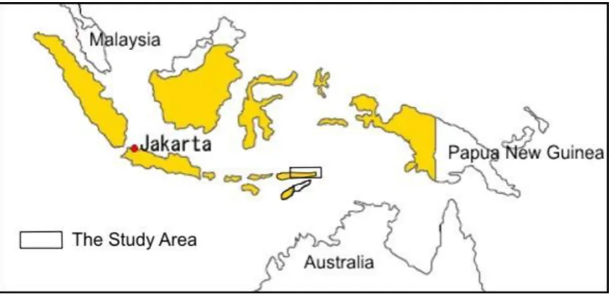
Eurasian Plate and either Indo-Australian Plate or Pacific Plates. The study was done in Maumere,
Flores island (Figure 1).
On 12th of December 1992 there was earthquake and tsunami disaster in Maumere and its
surrounding areas, killing thousands people and damaging millions rupiah values of infrastructures.
There was a phenomenon that coast area with a specific shoreline geometry more vulnerable to tsunami
than others. Therefore, in order to assess the correlation of curve geometry of coastal line and the
intencity of tsunami impact, this study was done by applying fractal analysis. Results of the study is
expected able to be used to predict the impact intencity of tsunami in other areas with similar coastal
line characteristics.
Method of Study
This study combined field geologic surveys and fractal analyses, utilizing both primary and secondary
data. Application of fractal analysis in this study is to quantify the coastal lines curve values in the study
area. Despite prepared on desk while determining fractal dimension, field surveying was also done in
order to acquire data on geological condition and tsunami impact including victims and damages. The
secondary data on victims were derived from local government offices.
Fractal scaling system is specified by non-integer numbers so called fractal dimension (Bunde &
Havlin, 1994). Determination of fractal dimension is important in practical quantification problems. It
fractal dimension in this study, box-counting method was applied, done by drawing grids with certain
length side (r) over the fractal objects. Then the fractal dimension (D) is determined using equation:
r
F
Nr
D
r
log
)
(
log
lim
(1)
Where Nr(F) is the number of boxes that cover the fractal set (F), and ris the length of the box side. The
computation of Nr(F) is repeated by changing the length of the box side (r), so that r approaches zero.
Nr(F) values and r are plotted on a log-log graph to derive the fractal dimension, e.g., the slope of the
plot (Tricot 1996).
To obtain fractal dimension values, the shorelines along the study area were divided into 28
segments. The division were based on their curve pattern similarity, obtained from topographic map of 1
: 25.000, and air photos of tracing of 1 : 30,000 scales. The fractal dimension of every coastal line
segment was then determined by box counting method. Next, values got from the fractal dimension
computation were compared to field data and informations, especially related to the impact of tsunami
had ever happened.
Geology
According to USGS (2005) data, the relative plates motions of Eurasia is southeastward by 4 cm/ year,
Indo-Australia is northward by about 7 to 9 cm/ year, and Pacific is westward by 11 cm/year. Eurasia
Plate meets Indo-Australia Plate along the southern part of Sunda and Nusa Tenggara Islands from
Sumatra, Jawa to Nusatenggara.
Flores island belongs to East Nusa Tenggara Islands. Shape of the island is unique, bordered by a
rough geometric of coastal line, with some active volcanoes in the middle parts. Some of the volcanoes
are Ili Lewotobi Laki-laki (1584 m), Ili Lewotobi Perempuan (1703 m), Keli Bara (1631 m), Keli Mutu
(1640 m), Mount Iya (659) m, Mount Rokatenda (P. Palue, 875 m), and Egon Mountains in the eastern
Flores with some highs of 1703 m and 1838 m above sea level.
The oldestrock formation of Flores is Miocene age, consists of volcanic breccia, lava, basaltic to
ryolitic tuff sandstone. This rock unit is interfingered to Nangapanda Formation that consists of
calcareous fine grain clastic sediments and limestones. The rocks are unconformably overlain by
volcanic products of Pliosen to Quaternary age. The youngest Rock units are coral limestone, coastal
Nusa Tenggara islands including Flores are charactrized by complex geologic structures. There are
some faults formed from plates interactions, crosscutting Flores island generally striking northeast –
southwest and northwest – southeast. They not only exist in the south but also in the north parsts of the
island. The transformal and trust faults in the noth part often creat shallow destructive earthquake.
Flores Earthquake and Tsunami, 12 Desember 1992
Tsunami is usually triggered by seafloor earthquake of more than 6.5 magnitude. When subducting plate
breaks, resulting crust deformation, there will be volumetric spatial change bringabout sea water
absorbed into the space of deformation. This causes in general the occurrence of tsunami. It is initially
started with seawater level drop for several meters to kilometers after the earthquake. Later, there will be
such a great wave comes back to the shore with high velocity and destructive energy. This happens due
to hydrostatic and hydrodynamic balancing to reach its stability.
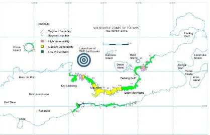
Some coastal areas of Indonesia especially those facing the plate boundaries are vulnerable to
tsunami (Figure 2). Since 1901 to 2006 period, there were more than 75 great tsunamis happenned in
Indonesia, about 85% of them occurred in the eastern part of Indonesia, including Nusa Tenggara
islands where Flores located. Maumere eventhough situated in the northpart of Flores, is not able to
avoid tsunami risk. This is caused by some transformal faults as the result of interaction between Pacific
Plate, Eurasia Plate, and Indo-Australia Plate. The subduction and transformal faults control the
existence of active faults striking northeast – southwest and northwest – southeast of Flores.
There was a tectonic earthquake followed by tsunami attacking Flores in Saturday, 12th of
December 1992 on 13.30 pm in the local time. The disaster destructed Maumere, the capital city of
Sikka Region and Larantuka of East Flores Region, were influenced by back arc tectonic activity along
the north of East Nusa Tenggara Islands. The tsunami killed 2.080 people and damaged infrastructures
of Sikka Region. Infrastructures were destructed including hauses, offices, schools, and many others.
Thousands missed their hauses and jobs (Satlak PB Sikka Region, 1994).
Acording to the Board of Meteorology and Geophysics (BMG) of Kupang (2007), the earthquake
source was located under the seafloor, on the coordinate of 8,42o South Latitude and 122,10o East
Longitude, 36 km depth, 30 km distance of northrn Maumere, with magnitude of 6,8 Richter scale; and
land area, with almost 10 m high of the wave. Wave hight in the harbour was 4 meters (BMG Kupang,
2007). The tsunami also beat the Babi island, north of Maumere (850 people died), Pamana island north
of Flores, Kalautoa island of Selayar Region, and South Sulawesi Province (killed 20 people, and
damaged some buildings).
Results and Discussion
Indonesia belongs to a country with the longest shorelines and most potential of tsunami disaster on the
world. According to Rahardjo (2005) coastal line configuration determine how serious the damage
caused by tsunami. Sub marine geomorphology and bathimetry influence how strong and high the
tsunami wave coming to the beach. The morphology of the shores of Maumere, as any other coastal
areas, there will be high potential when the coast has a gulf or fyords. Factors influencing the shape are
lithology, geomorphology, and geologic structures of the area. Despite those geologic factors,
exodynamic processes such as abrasion and coastal sedimentation also play important role. Curve of
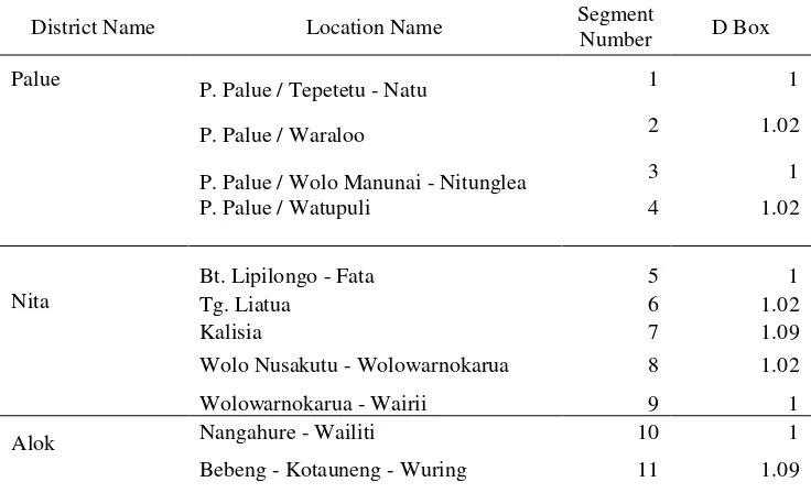
coast lines belong to fractal geometry. Ranges of fractal dimensions (D) of the coastal lines can be
grouped into four, i.e. D = 1 - 1,05, D = 1,05 - 1,1, D = 1,1 – 1,15, and D = 1,15 – 1,2, that can be seen
in the Table 1 (See Figure 3).
Coast with fractal dimension > 1 is usually displaying fjord and embayment morphology, there is
intensive sedimentation, and influenced by the existence of active faults. Comparing the values of fractal
dimension of the coastal lines in the study area and the impact of tsunami in the past time, there is a
positive correlation of fractal dimension value and the impact intensiveness. The higher the fractal
dimension of the coastal lines, the more serious the damage of the area, including the number of people
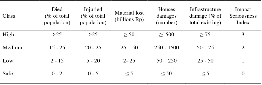
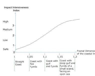
died. Based its intensiveness, tsunami impact on coastal lines correlated to their fractal dimension can be
indexed as 0, 1, 2, and 3, and classified into four classes, e.g. safe, low, medium, and high (Table 3).
There is positive correlation beetwen value of fractal dimension and the seriousness of tsunami impact.
Impacts of tsunami Maumere 12 December 1992 were listed in the Table 3, while Figure 4 shows the
correlation of fractal dimension of coastal lines in the study area and tsunami impact intensiveness.
Alok is a district of which fractal dimension value of the coast equals to 1.09. Although this value is
not so high, but in fact, when the tsunami happened, this area suffered from serious damage and too
population in this district. At that time, the community of Wuring village built their houses too close to
the open sea (Satlak PB Sikka region, 1994). Therefore a major destruction was not able to be avoided.
Conclusions
1. Due to the tectonic setting of Indonesia, most of the southern coastal lines, which facing the
subduction zone of Indo-Australia plate and close to some transform faults are high potential for
tsunami
2. Tsunami destroyed Maumere and surrounding area in 1992 was caused by back arc transformal
fault movement triggered by the subduction activity of Indo-Australia Plate beneath Eurasia Plate.
3. Based on tsunami impact intensiveness and its fractal dimension, coastal lines in the study area can
be classified into “safe” with fractal dimension 1 – 1.05, “low” with fractal dimension 1.05 – 1.1,
“medium” with fractal dimension 1.1 – 1.15, and “high” with fractal dimension > 1.2
4. There is a positive correlation between the fractal dimension value of the coastal lines geometry and
impact intensiveness of tsunami in Maumere area. The higher the fractal dimensions of the coastal
line geometry, the more serious the damage of the area by tsunami.
5. Despite correlated to morphology of the coastal line, expressed by its fractal dimension, the
seriousness of tsunami impact also depends on the population of the area, as shown by Alok district.
References
Badan Meteorologi dan Geofisika (BMG), Kupang, 2007, History of Tsunami in Flores 1992
Bunde, A. & Havlin, S., 1994, Fractals in Science, Springer Verlag, Amsterdam, 298p.
Bupati Kepala Daerah Tingkat II Sikka, 1993, Report on earthquake and tsunami 12th December 1992, Sikka Region, 5th – 6th July 1993
Harjadi P., 2008, Earth environmental aspect and monitoring system, Proc. Seminar on Trend of Earth Science Researches, Bandung 28th October 2008, 64-71
Kusumayudha, S. B., Zen, M.T., Notosiswoyo, S., Gautama, R.S 1999, Fractal analysis of the Oyo river, cave systems and topography of the Gunungsewu karst area, Central Java, Indonesia, Hydrogeology Journal Vol 8 No 3, 271–278.
Kusumayudha, S.B., 2002, Mapping landslides vulnerable areas by fractal analysis: An alternative method, Proc Symposium of Sediment Disaster Prevention, S.T.C, 251-256.
Latief, H. dkk. 2005, Tsunami Aceh, Tsunami Research Group, Marine Research and Development Group, Institute of Technology, Bandung.
Mandelbrot, B.E., 1983, The Fractal Geometry of Nature, W.H. Freeman & Co., Springer Verlag, New York, 468 p.
Rahardjo, P. P., 2005, Impact of earthquake and tsunami of Nanggroe Aceh Darussalam, Proc of Discussion on post disaster mitigation of Aceh earthquake and tsunami, University of Parahyangan, Bandung.
Satlak PB Sikka Region, 1994, Report on disaster mitigation of earthquake and tsunami 12th December 1992, Sikka Region, 12th January 1994.
Suwarna, N., Santosa, S. dan Koesoemadinata, S., 1990, Geologic map of Ende, Nusa Tenggara Timur, Sheets 2207, 2208, 2307, 2308, skala 1 : 250.000, Pusat Penelitian dan Pengembangan Geologi, Bandung.
Tricot, C. (1996). Curves and Fractal Dimension, Springer Verlag, New York, 323 p.
USGS, 2005, Preliminary earthquake report for the west coast of Northern Sumatra (2004 December 26 00:58:53 UTC), United States Geological Survey, USGS alert, Retrieved, March 3, 2005.
http://serc.carleton.edu/NAGTWorkshops/visualization/collections/tsunami.htm.
http://sim.nilim.go.jp/GE/SEMI2/Proceedings/Makalah%203.doc, Penggunaan citra untuk memantau perubahan dan kerusakan kawasan pantai.
http//www.indonesiamercycorp.org, (2005), Post Disaster Programs.
http://www.geocities.com/kliping
http//serc.carleton.edu, (2005)
Table 1. Segments of Coastal Line and Fractal Dimensions of Maumere, Flores.
District Name Location Name Segment
Number D Box
Palue P. Palue / Tepetetu - Natu 1 1
P. Palue / Waraloo 2 1.02
P. Palue / Wolo Manunai - Nitunglea 3 1
P. Palue / Watupuli 4 1.02
Nita
Bt. Lipilongo - Fata 5 1
Tg. Liatua 6 1.02
Kalisia 7 1.09
Wolo Nusakutu - Wolowarnokarua 8 1.02
Wolowarnokarua - Wairii 9 1
Alok Nangahure - Wailiti 10 1
Wairotang -Waioti 12 1
Kewapante Waipare - Kewapante 13 1.01
Waigete
Nangahale - Wairita 14 1
Wairita 15 1.02
Waigete - Nangahalelama 16 1
Talibura Nangahale - Wairmude 17 1
Lemiwair 18 1.09
Nangamerah-Langloeng 19 1.05
Baukremut - Kabal 20 1
Tanahdewa 21 1.13
Maumere P. Babi 22 1.17
Paga Iliwolokoli - Paga 23 1
Legebai Bhera - Wara 24 1
Lela Tiget - Sikka 25 1
Bola Hokor - Waigete - Doreng 26 1
Hebing 27 1,02
Hebing 28 1,04
Tabel 2. Classification of Tsunami Impact Intensiveness
Class
Died (% of total population)
Injuried (% of total population) Material lost (billions Rp) Houses damages (number) Infrastructure damage (% of total existing)
Impact Seriousness
Index
High >25 >25 ≥ 50 ≥1500 ≥ 75 3
Medium 15 - 25 20 - 25 25 – 50 250 - 1500 50 – 75 2
Low 2 - 15 5 - 20 2- 25 50 – 250 25 - 50 1
Safe 0 - 2 0 - 5 ≤ 5 ≤ 50 ≤ 5 0
Tabel 3. Fractal Dimensions and Tsunami Impacts.
Name of District Fractal Dimension Number of Human
Victims
Amount of Lost
(billions Rp)
Infrastucture
Damages
Died Injuried
Maumere 1.17 791 127 59.35 190.14
Nita 1.02 – 1.09 16 158 48.42 249.21
Lela 1 13 80 9.45 174.13
Paga 1 14 21 7.07 149.56
Kewapante 1.01 9 100 11.05 239.14
Bola 1.02 28 27 5.4 185.96
Talibura 1.05 – 1.09 82 57 12.67 180.49
Palue 1.02 8 10 2.57 88.89
Waigete 1.02 1 7 5.79 152.12
Legebai 1 7 36 8.56 144.42
Figure 3. Map showing coastal lines (red color) which are potential of subjected to tsunami (http//serc.carleton.edu, 2005).