MEASUREMENT OF GLACIER VELOCITY AT PIK LENIN, TAJIKISTAN, BY
FEATURE TRACKING
S. Kumari a, *, S. K. Ghosh a, M. F. Buchroithnerb
a Civil Engineering Department, Indian Institute of Technology Roorkee, India – [email protected] b Civil Engineering Department, Indian Institute of Technology Roorkee, India, - [email protected]
c Institute of Institute for Cartography, Dresden University of Technology, Dresden, Germany - [email protected]
KEY WORDS: Correlation, Feature tracking, Glaciology, Image matching, Satellite Imagery.
ABSTRACT:
Glaciers, especially in mountain area are sensitive indicators of climate fluctuations and also contribute to present rates of sea level rise. In Central Asia, these glaciers are the primary resource for fresh water. Understanding the seasonal behavior of these glaciers would help to make efficient use of the available water reservoir. Different methods have been employed to study glacier displacements in past. The conventional survey techniques are very cost-intensive and highly depend on accessibility to high mountain glaciers also directs us to look for new ways to study these areas. Here remote sensing comes in handy with freely available data and a good coverage with high spatial and temporal resolution. Optical satellite imagery, available free can be effectively used for research purpose. The glacier in this region fed lake Karakul (380 km²), the largest Lake in Tajikistan. The objective is to study the displacement tendency of the Glacier in Pik Lenin area using Landsat 7 dataset. Normalized cross correlation algorithm has been implemented via CIAS to estimate the motion of glacier surface. A number of combination of reference block and search area size were tested for 30 m resolution dataset. As a result the specifications: reference block size of 15 pixels and search area size of 10 pixels was found out as the best set of parameters and considered for further processing. The study derives a reliable set of data depicting the velocities in the glacier which after post processing shows peak velocity of 121 m/y of the glacier.
1. INTRODUCTION
1.1 Overview
The Image matching is a group of techniques of finding corresponding features or image patches in two or more images taken of the same scene from different viewing positions, at different times and/or using different sensors. Image matching is used for a large variety of applications such as image (co-)registration, stereo parallax matching for generation of digital elevation models, particle image velocimetry (PIV), or displacement measurements (Brown, 1992; Westerweel, 1993; Zitová & Flusser, 2003). The group of area-based matching techniques is the most widely used method due to its relative simplicity (Zitová & Flusser, 2003).
Cross-correlation, particularly in its normalized form which accounts for brightness and contrast in image sequences, is the most widely used similarity measure of this method due to its reliability and simplicity (Lewis, 1995). The normalized cross-correlation (NCC) algorithm has been used to investigate Earth mass movements such as glacier flow and land sliding in many empirical studies (e.g. Scambos et al., 1992;) Although NCC has been documented to be simple and reliable, a number of drawbacks have been reported as well ( Scambos et al., 1992;). Firstly, NCC is sensitive to noise in the images. Secondly, NCC is sensitive to significant scale. For the measurement to be reliable the displacement has to be greater than the mean error of the image (co-)registration. The precision of NCC is, in principle, limited to one pixel, and thus varies with the pixel size of the image data used. Pixel-level accuracy might be satisfactory depending on the spatial resolution of the imagery available and the type of process being investigated. Improving NCC precision, however, improves displacement accuracy two fold: by reducing the image co-registration error and by improving the matching accuracy directly. The study area is the highlands of Tajikistan
and the surrounding high mountains, respectively. Accordingly, there is pronounced glaciations in that region. The glaciers, however, were hardly been studied scientifically. The goal is to study glacier dynamics in that area by feature tracking. Since the high mountains of Central Asia difficult to access are respectively a considerable logistical effort would have to be performed to operate field studies, has established itself as an alternative to study the glacier with methods of Remote Sensing (Bolch et al., 2008). Satellite-based systems allow multi-temporal analysis of large glaciated areas.
The acquisition of appropriate data records often prevent inadequate access to on-site measurements, the extensive observation of Glaciers and their flow behaviour, particularly in the high mountains. The remote sensing, especially the evaluation of optical satellite data, allows the study difficult to reach, extensive tracts of land without continuous on-site Perform measurements. In this context, the glacier flow velocities are examined in the Pik Lennin for the year 1999 and 2000, which have time difference of one year.
The present study focuses exclusively on Glacier surface movement analysis by NCC due to the wide-spread use of this technique, and its simplicity and reliability. Thus, we do not consider the above methods that are intrinsically capable of sub-pixel precision. Further, we concentrate on the input parameters to Correlation Image analysis Software (CIAS). These are reference and search area window size that mainly affect the correlation results. Till now, much focus is not given here.
1.2 Image Matching
Image matching is a group of techniques to look for corresponding features or patches within image. This can be achieved from two or more images taken of the same area but
having different viewing positions, at different times and/or using different sensors. The popularity of this technique is its applications in numerous fields viz. image (co-) registration, DEM generation and last but not the least displacement measurements (Brown, 1992; Zitová & Flusser, 2003).
Area-based matching techniques because of their simplicity are the most commonly used method (Zitová & Flusser, 2003). Cross-correlation, more precisely in its normalized form, is the most widely used similarity measure of this method due to its reliability and simplicity The features considered are brightness and contrast in image pairs. The normalized cross-correlation (NCC) algorithm has been used to investigate earth mass movements such as glacier flow and land sliding in many studies (e.g. Scambos et al., 1992).
With the popularity of NCC in the above mentioned applications comes a list of drawbacks as well that are documented eventually. A few like sensitivity to noisy images, it may give erroneous results when there is significant difference in scale, rotation or shearing between the images to be correlated. As there can be some errors in (co-)registration, the displacement to be reliable should be greater than those errors. Whether implemented in any software precision of NCC is dependent upon the spatial resolution of input image data used. Thus satisfactory pixel-level accuracy can be achieved using images of appropriate spatial resolution suitable for type of process being investigated. Improvement in NCC precision means improving the displacement accuracy.
Mass movement, for geologists and glaciologists, refers to the movement of earthy substances including rocks, ice and debris initiated by forces due to gravity, water, and tectonic movement (Ritter, 2006). These movements range from order of centimeters to several meter per year. For sub-pixel precision of image matching algorithms NCC has a great potential to improve the SNR of the measurements. Better the precision (i.e. level of detail of the measurement) of displacement better will be accuracy (i.e. the certainty of the estimation). Many Earth surface mass movements such as landslides, glacier flow, and rock glacier creep are studied by displacement rates which is usually the same order of magnitude as the spatial resolution of the imagery available as input.
1.3 Normalized Cross Correlation (NCC)
The Normalized Cross-Correlation (NCC) algorithm is a similarity measure that is used in image matching to measure the similarity between matching entities in one image and their corresponding entities in the other image. The algorithm was developed based on the concept of distance measure but normalized in order to compensate for the differences in brightness and contrast. The present study focuses exclusively on glacier movement analysis by NCC due to the wide-spread use of this technique, and its simplicity and reliability. The terms used here are elaborated below as:
1. I1 and I2 are the image taken at two time periods 2. f(x, y) represents the intensity values of a selected area
t(x−u, y−v).
3. t(x−u, y−v) is a subset of I1.
4. u and v are integer pixel offsets in x- and y-direction respectively.
Figure 1. Scheme of the image pairs together with the reference template, central pixel, search template and the
search window. (Debella-Gilo et al., 2011)
f(x, y) is also referred to as reference template and t(x−u, y−v) is called search template. The size of the template is chosen to be large enough to maximize the signal-to-noise ratio and small enough to minimize velocity gradients. The search area size should be chosen large enough to measure for the farthest moving template and small enough to limit the software and memory related problems of the platform. To find the corresponding square to f(x, y) in I2, the normalised cross-correlation coefficient (ρ) between f(x, y) and corresponding window in I2, t(x−u, y−v), is computed. The NCC coefficient ρ is computed as given in Eq. (1) and is assigned to the central pixel of the template
The process goes on by updating the value of t in every iteration by 1 pixel eventually the entire search window is covered. Once the computation is complete, the pixel (x0, y0) in the search window having the highest correlation coefficient is considered to be the best match for the central pixel of the reference template. The Euclidean distance between the coordinates of the reference point [x, y] and the matching point [x0, y0] is considered as the horizontal displacement magnitude, d(x, y).
� , =√∑ , � , − �∑ , (� , − �′ �′ ∑ , )( − , − − − , − − ′) ′ � (1)
f’ is the mean of the intensities in the reference template f(x, y) and t’ is the mean of the intensities in the search template t(x−u, y−v).The values of ρ range between −1 to 1. -1 for matching entities which are inverses of each other and 1 for those are similar. ρ=0 indicates that there is no relation between the entities that are matched. It may happen that even there is no true correspondence between the images, there lies a set of correlation coefficients and thus a peak among them. It is necessary to decide a threshold for ρ below which the matched results have to be rejected. they may also be the first word of the paragraph's sentence.
1.4 Correlation Image Analysis Software (CIAS)
Correlation Image Analysis Software was developed by Andreas Kääb (2013), in collaboration with Markus Vollmer. This comes as a stand- alone and free which can be easily downloaded from internet. CIAS implements NCC and NCC-O algorithm, where the NCC-O (Normalized Cross Correlation - Orientation) comes in beta version. Taking input data into consideration it takes two co-registered grayscale images of same area but with different
time periods as per the requirement of any matching algorithm. These images must have same resolution. However input data to be already co-registered is not necessary because there is an option for co-registration of the images using Helmert transformation. The overall movement is measured in meters (default) but can vary if the input images have different reference system. One very important output type is direction of movement which is provided as output in degrees (°), and the corresponding correlation parameters like average correlation coefficient (avg_corrcoeff) and maximum correlation coefficient max_corrcoeff are also given as output in ASCII format. While execution of the program, a help report is generated this provides assistance for selecting suitable parameters and settings and then saved in a log file.
2. STUDY AREA AND DATASET
2.1 Study Area
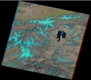
Its center lies at approximately 39° N. and 73° E. and thus in Central Asia, specifically in Tajikistan near the border with northern neighbor Kyrgyzstan in the autonomous province of Gorno-Badakhshan , which in many publications is abbreviated as GBAO , derived from the English name Gorno- Badakhshan Autonomous Oblast. In the overview map (Figure 1) is to orient the location of the study area recorded.
Figure 2. Study area
Figure 3. A closer look at the study area and nearby lake Karakul
2.2 Dataset
The glacier flows precision depends on the quantity and quality of the correlation between the images, such as no cloud cover etc. This is the reason why it is important to use the best available images. The data is downloaded from
www.earthexplorer.usgs.gov. Prominent changes in between
images can lead to bad results using the NCC approach, that’s why it is not useful to use the images with more than 2 years of
difference between them. Another aspect to consider is the amount of snow in the areas, covering the debris, which complicate good matches.
Figure 4. Landsat 7 Etm+ Dataset from 07-SEP-1999 of study area
Image of time 1 Image of time 2
ID LE71510331999250SGS
00
LE71510332000237SGS 00
Acquisition
Date 07-SEP-1999 24-AUG-2000
Sensor L7 ETM+ L7 ETM+
WRS
Path/Row 151/033 151/033
Data type
level 1 ETM+ L1T ETM+ L1T
Table 1. Datasets used for processing with CIAS
3. METHODOLOGY
Methodology consists of these basic steps
1. Take subset of two imageries of the study area nearly of one year of difference.
2. Perform image correlation using CIAS. 3. Post processing and filtering the data obtained. 4. Representation of final velocities.
Each of these steps is discussed in the following section and following headings. Start paragraphs flush with left margin.
3.1 Subset formation
The need for working with subset imagery as input is necessary because CIAS is particularly suitable for testing smaller study areas. If larger, these high-resolution image areas on convergence, lead IDL-related memory problems sometimes to program crashes. In addition to this the processing time increses if larger images are used.
Figure 5. Subset of L7 dataset Band 8 used as input to CIAS
3.2 Processing with CIAS
The robust method of NCC works in screen space and is intrinsically used here. Giving as input, two images with similar image content, added to two different times, usually serves the first period as a reference recording. About the definition of search windows image areas are defined, which are investigated in a further storage for maximum convergence. For the analysis of glacier flow rates over the spatial variation detection of distinctive features that serve orthorectified Landsat TM images of the observation period 1999/2000. The optional co-registration by CIAS is thus omitted.
3.2.1 Input subset images: The software used to compute the displacement between two images has been CIAS Image correlation. The software is based on NCC. The images used for the correlation need to have the following requirements: Exactly the same resolution, Single channel (greyscale), Square resolution in images x and y.
3.2.2 Set the parameters: CIAS offers to perform NCC with a very organized and in easy to perform steps. After inputting the images to be correlated, it asks for certain parameters in order to execute. These parameters being ‘reference block size (pixels), search area size (pixels), raster resolution (m)’. Here raster resolution is the resolution at which we want to perform the correlation and visualize the results. The steps to performed for matching are described below.
1. Input the parameters: Reference block sizes should be given in pixels around 10-20, for very noisy images it can be further increased. In present scenario this size is varied for 10, 15 and 20 to test which combination of parameters gives the best result.
2. Search area size in pixels has to be at least double of the expected maximum displacement. Here three different types of search area have been tested for clarity of results.
3. Grid distance in pixels is the raster resolution of measurement points. Here 30 m is used as grid size for each band data.
4. The output of the correlation is a txt file which needs to converted into a .csv file. Then, it is imported to ArcGIS to create the shapefile.
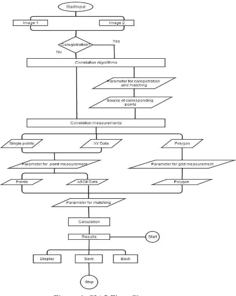
The workflow is run by a wizard and is schematically illustrated in the form of a flow chart in the Figure 6 as outlined.
Figure 6. CIAS Flow Chart
3.3 Post processing of CIAS output
CIAS transmits the measured offsets in tabular form and are the parameters the maximum and mean correlation coefficients to assess the reliability of each measurement. The correlation results we get as output cannot be represented as the final glacier movement statistics. For the elimination of spurious correlations, it needs to be processed and interpreted by the user. It needs to be filtered for increasing the authenticity of data. First of all measured values are to be removed, which are not included in the glacier region or they are completely snow covered region because CIAS does not work for those areas as mentioned in earlier studies. Next is the elimination of spurious and decorrelation measurements in the registered movement rates in the period 1999/2000.This is to be done first deciding which combination of matching parameters (reference block size, search area size and raster resolution) gives better results. As discussed earlier, the size of the template is chosen to be large enough to maximize the signal-to-noise ratio and small enough to minimize velocity gradients. Also the search area size is chosen to be large enough to include the farthest moving template and small enough to limit the computational cost of the matching. In order to get reliable data the measurement values only should further be filtered. For displacement measurements percentile is applied to filter out the data which seems not very relevant. Similarly directional component of measurements need to be ignored if they do not follow the topography.
4. RESULTS AND DISCUSSION
4.1 Results
For different sets of parameters tested for quality of correlation. The best combination of parameters came out to be reference block size = 15 pixels, search area size = 10 pixels and the raster resolution was unchanged to 30m, as can be seen from Figure 7.
Figure 7. Variation of Search Area window size for constant Reference block size of 15 pixels a)Search window size = 5 pixels, b)Search
window size = 6pixels, c)Search window size =10 pixels
Once the parameters are fixed then comes filtering the results according to correlation coefficient. For this, whole dataset (band 4) is divided into two groups about median of displacement field µv which is 8.38 m for one year. Then the median is calculated for two sets (µv < v and µv > v) for maximum correlation coefficient (max_corr_coeff) and average correlation coefficient (avg_corr_coeff). This gives a range of max_corr_coeff between [0.896, 0.959] and avg_corr_coeff [0.364, 0.384]. By further analysis it is detected to be 0.90 for max_corr_coeff, which gives good results which also can be visually seen. Thus all the values with max_corr_coeff >= 0.90 were taken as data set to be processed further.
This filter is applied to data of different bands.It also has a smooth variation in velocity as one would expect for a glacier movement. The middle part of glaciers with highest velocities still preserved and behaves as expected from a normal movement of glacier. The upper region of glaciers with spots is the area covered with snow so good matches not observed. While lower regions shows there can be portion of glacier covered with debris. The velocities even at this stage are high for a glacier.
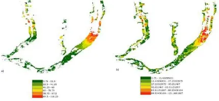
While studying glacier dynamics the measurement of velocity is very important. The processing till now is not sufficient to say if the final velocity in the study area is reliable and if yes then how much reliable? So here velocities coming under the range of 98.3 percentile are only considered to be reliable. This filtering eliminates all the glacier displacement greater than 116m (for band 4 data) and 121 m (for band 6 data). Final step to filter the results is to eradicate erroneous directional velocities. By looking on the shape of glaciers it is certain that any velocity in direction of north is not acceptable, whatever may be the reason it cannot add to the glacier flow as a whole. The values <90o and >315o are eliminated and hence the final glacier flow is shown below in Figure 8
Figure 8. Final glacier movement shown after removal of velocities with angle < 90o and angle > 315o for a) band 4 and b)
band 6
Figure 9. A closer look at the middle of glacierresults shown for Band 4.
4.2 Discussion
Looking at the data types that can be used in CIAS, there are only two, Tagged Image File Format (TIFF) - or GeoTIFF and must be with a resolution of square pixels. On the other hand there is great support which is continuously generated at run time and explanations and notes on current parameters and expected computation times supplies. It even tells what and how to save certain data for future reference. Furthermore, CIAS enjoys ongoing development and bug fixes. CIAS is characterized by a simple, purpose-oriented program structure and guides the user through a pre-defined workflow of the correlation measurement to the bottom line without an extensive training process is required. As there is no fixed set of parameters defined previously that can work for matching images. The set useful in this context is found by testing a variety of parameters and thus selecting the best one. As shown in figure 5.4 application of correlation coefficient filter, certain blank spots are visible which shows that CIAS fails for low contrast image. Also these are greater in upper region of the glacier where snow cover is present. On debris-covered ice, however, the results look quite non unidirectional but also promising. In the upper part of the Grand Saukdaragletscher, ice speeds of up to 116 m/y is observed, continuously and very smoothly decreasing to the lower part as well as boundaries section with velocity of 3.75m/y. Since the correlation is high so these values are reliable.
A closer look at the confidence level of the employed NCC algorithm as a whole, which is from the ratio of the number of remaining values after elimination of obvious miscorrelations, the total number of detected movement rates in masked glacier area determined was an average behavior of 15278 out of 26888 points for band 4 and 18263 out of 41641.
Procedure Total no. of points Points remained
after procedure
Band 4 Band 6 Band 4 Band 6
Elimination of values with max_corr_coeff < 0.90
26888 41641 15278 18559
Elimination of displacement values
beyond 98.3
percentile
15278 18559 15008 18263
Elimination of points with erroneous direction
15008 18263 10861 14141
Table 2. Record of remaining points after each step in post processing
5. CONCLUSION
This thesis demonstrates the possibility to measure the surface kinematics in terms of surface velocity in Pik Lenin, Tajikistan. To obtain the velocity information of the glacier, a feature tracking method, based on cross-correlation, has been applied to the optical imagery of Landsat 7 data.
Area of interest was the glacier part of Lenin Pik glacier system within the Pamir. With data available from September to August for 1999 and 2000, respectively, it was shown that Landsat data is highly suitable for monitoring glacier displacements especially using CIAS, as it is able to correlate images in context and works well with the resolution of dataset available.
From the large amount of data freely available it came out to be a few dataset that can be used as input for CIAS, without preprocessing. Also eliminating the image pairs that fall in different season, results showed the glacier moves with a maximum velocity of 121 m/y slows down eventually towards the tip of the glacier upto 3.75 m/y. The following major limitations were found during processing: Cross-correlation results with maximum correlation coefficient greater than 0.90 is promising and thus can be relied upon for glacier surface change. A few debris-free areas like the bare icy longitudinal ramps, did not show any displacement information due to substantial surface melting processes for this non-polar glacier.
REFERENCES
Ayoub, F., Leprince, S., Keene L. (2009a). User’s Guide to COSI-CORR. Coregistration of Optically Sensed Images and Correlation.http://www.tectonics.caltech.edu/slip_history/spot_ coseis/pdf_files/cosi-corr_guide.pdf [Stand: 31.07.2013].
Kääb, A. (2013). Image Correlation Software CIAS. http://www.mn.uio.no/geo/english/research/projects/icemass/cia s/index.html [Stand: 15.07.2013].
Bolch, T., Buchroithner, M., Pieczonka, T. & Kunert, A. (2008). Planimetric and volumetric glacier changes in the Khumbu Himal, Nepal, since 1962 using Corona, Landsat TM and ASTER data. Journal of Glaciology 54, S. 592-600.
Brown, L. G. (1992). A survey of image registration techniques. ACM Computing Surveys (CSUR), 24(4): 325-376.
Debella-Gilo, M., & Kääb, A. (2011). Sub-pixel precision image matching for measuring surface displacements on mass movements using normalized cross-correlation. Remote Sensing of Environment, 115(1), 130–142.
Scambos, T. A., M. J. Dutkiewicz, J. C. Wilson, and R. A. Bindschadler, 1992. Application of image cross-correlation to the measurement of glacier velocity using satellite image data. Remote Sensing Environ., 42(3), 177-186.
Scherler, D., Leprince, S., Strecker, M. R. (2008). Glacier-surface velocities in alpine terrain from optical satellite imagery-Accuracy improvement and quality assessment. Remote Sensing of Environment, 112(10): 3806-3819.
Zitová, B., Flusser, J. (2003). Image registration methods: a survey. Image and Vision Computing, 21(11): 977-1000.