Kecamatan Karossa Dalam Angka 2019
|
i
https://mamujukab.bps.go.id
Karossa Subdistrictin Figures
2019
ISSN: 2655-0636
No. Publikasi/Publication Number: 76060.1808
Katalog/Catalog: 1102001.7606050
Ukuran Buku/Book Size: 14,8 cm x 21 cm
Jumlah Halaman/Number of Pages: xxii + 108 halaman /pages
Naskah/Manuscript:
Badan Pusat Statistik Kabupaten Mamuju
BPS-Statistics of Mamuju Regency
Gambar Kover oleh/Cover Designed by:
Badan Pusat Statistik Kabupaten Mamuju
BPS-Statistics of Mamuju Regency
Ilustrasi Kover/Cover Illustration:
Pulau Kambunong/Kambunong Island
Diterbitkan oleh/Published by:
© Badan Pusat Statistik Kabupaten Mamuju/BPS-Statistics of Mamuju Regency
Dicetak oleh/Printed by:
CV. Mitra Karya
Dilarang mengumumkan, mendistribusikan, mengomunikasikan, dan/atau
menggandakan sebagian atau seluruh isi buku ini untuk tujuan komersial tanpa izin
tertulis dari Badan Pusat Statistik
Prohibited to announce, distribute, communicate, and/or copy part or all of this book
for commercial purpose without permission from BPS-Statistics Indonesia
Kecamatan Karossa Dalam Angka 2019
|
iii
PETA WILAYAH KECAMATANKAROSSA
MAP OFKAROSSA SUBDISTRICT
Kecamatan Karossa Dalam Angka 2019
|
v
KEPALA BPS KABUPATEN MAMUJU
CHIEF STATISTICIAN OF MAMUJU REGENCY
Wisman Nainggolan, S.Si., M.Si.
https://mamujukab.bps.go.id
Kecamatan Karossa Dalam Angka 2019
|
vii
KATA PENGANTAR
Kecamatan Karossa Dalam Angka 2019 merupakan publikasi tahunan
yang diterbitkan oleh BPS Kabupaten Mamuju.Disadari bahwa publikasi
ini belum sepenuhnya memenuhi harapan pihak pemakai data
khususnya para perencana, namun diharapkan dapat membantu
melengkapi penyusunan rencana pembangunan di Kecamatan Karossa.
Publikasi ini dapat terwujud berkat kerja sama dan bantuan dari
berbagai pihak baik instansi pemerintah maupun swasta. Kepada
semua pihak yang telah memberikanbantuan disampaikan
penghargaan dan terima kasih yang sebesar-besarnya.
Walaupun publikasi ini telah disiapkan sebaik-baiknya, namun disadari
masih ada kekurangan dan kesalahan yang terjadi.Untuk perbaikan
publikasi ini, tanggapan dan saran yang bersifat konstruktif dari para
pemakai sangat diharapkan.
Mamuju, September 2019
Kepala BPS
Kabupaten Mamuju
Wisman Nainggolan, S.Si., M.Si.
PREFACE
Karossa Subdistrict in Figures 2019 is an annual publication written by
BPS-Statistics of Mamuju Regency.Honestly, this publication has not
perfect yet and has not filled the user’shope, especially for the planners
yet, but hopely it can help to equip compilationof development planning
in KarossaSubdistrict.
This comprehensive publication has been made possible with the
assistanceand contribution from several governmental institutions and
privateorganizations. To all parties who have been involved in the
preparation of thispublication, I would like to express my sincerest
appreciation and gratitude.
Comments and constructive suggestions for the improvement of
thispublication are always welcome.
Mamuju, September 2019
Chief Statistician of
Mamuju Regency
Wisman Nainggolan, S.Si., M.Si.
Kecamatan Karossa Dalam Angka 2019
|
ix
DAFTAR ISI/CONTENTS
halaman
page
Peta Wilayah KecamatanKarossa/Map OfKarossa Subdistrict ... iii
Kepala BPS Kabupaten Mamuju/Chief Statistician Of Mamuju Regency ... v
Kata Pengantar/Preface ... viii
Daftar Isi/Contents ... ix
Daftar Tabel/List Of Tables ... xi
Daftar Gambar/List Of Figures ... xviii
Penjelasan Umum/Explanatory Notes ... xxi
1
Geografi dan Iklim/Geography and Climate ... 1
1.1
Geografi/Geography ... 7
1.2
Iklim/Climate... 13
2
Pemerintahan/Government ... 15
2.1
Wilayah Administratif/Administrative Area ... 21
2.2
Pegawai Negeri Sipil/Civil Servants ... 23
3
Kependudukan/Population ... 25
4
Sosial/Social ... 39
4.1
Pendidikan/Education ... 47
4.2
Kesehatan/Health ... 60
4.3
Agama/Religion ... 64
4.4
Kriminalitas/Crime ... 66
4.5
Kemiskinan/Poverty ... 67
5
Pertanian/Agriculture ... 69
5.1
Tanaman Pangan/Food Crops ... 77
5.2
Hortikultura/Horticulture ... 78
5.3
Perkebunan/Estate Crops ... 80
5.4
Peternakan/Livestock... 81
6
Industri, Energi, dan Perdagangan/Industry, Energy, And Trading ... 83
6.1
Industri/Industry ... 89
6.2
Energi/Energy ... 92
https://mamujukab.bps.go.id
7
Komunikasi, Pariwisata, dan Harga/Communication, Tourismand Price ... 97
7.1
Komunikasi/Communication ... 103
7.2
Pariwisata/Tourism ... 104
7.3
Harga/Price ... 107
Kecamatan Karossa Dalam Angka 2019
|
xi
DAFTAR TABEL/LIST OF TABLES
halaman
page
1
GEOGRAFI DAN IKLIM/GEOGRAPHY AND CLIMATE
1.1
GEOGRAFI/GEOGRAPHY
1.1.1
Luas Wilayah Menurut Desa di Kecamatan Karossa, 2018/Total Area
by Village in Karossa Subdistrict, 2018 ... 7
1.1.2
Tinggi Wilayah di Atas Permukaan Laut (DPL) Menurut Desa di
Kecamatan Karossa, 2018/Height Above Mean Sea Level (AMSL) by
Village in Karossa Subdistrict, 2018 ... 8
1.1.3
Jarak AntarDesa di Kecamatan Karossa, 2018/Distance
BetweenVillages in Karossa Subdistrict, 2018 ... 9
1.1.4
Letak Geografis Menurut Desa di Kecamatan Karossa,
2018/Geographical Location by Village in Karossa Subdistrict, 2018... 10
1.1.5
Topografi Wilayah Menurut Desa di Kecamatan Karossa,
2018/Topographical Areas by Village in Karossa Subdistrict, 2018 ... 11
1.1.6
Nama Sungai yang Melintas dan Gunung Menurut Desa di
Kecamatan Karossa, 2018/Name of Across River and Mount by
Village in Karossa Subdistrict, 2018 ... 12
1.2
IKLIM/CLIMATE
1.2.1
JumlahCurah Hujan danHari Hujan Menurut Bulan di Kecamatan
Karossa, 2018/Amount ofPrecipitation and Number of Rainy Days by
Month in Karossa Subdistrict, 2018 ... 13
2
PEMERINTAHAN/GOVERNMENT
2.1
WILAYAH ADMINISTRATIF/ADMINISTRATIVE AREA
2.1.1
KlasifikasiPemerintahan Wilayah Administrasi di Kecamatan Karossa,
2018/GovernmentalClassification of Administrative Area in Karossa
Subdistrict, 2018 ... 21
2.1.2
Banyaknya Lingkungan, Dusun, Rukun Warga (RW) dan Rukun
Tetangga (RT) Menurut Desa di Kecamatan Karossa, 2018/Number of
Sub Village,People Association, and Neighbourhood Association by
Village in Karossa Subdistrict, 2018 ... 22
2.2.1
Jumlah Pegawai Negeri Sipil Menurut Instansi, Pendidikan Tertinggi
yang Ditamatkan, dan Jenis Kelamin di Kecamatan Karossa,
2018/Number of Civil Servants by Institution, Educational
Attainment, and Sex in Karossa Subdistrict, 2018 ... 23
2.2.2
Jumlah Pegawai Negeri Sipil Menurut Instansi, Golongan, dan Jenis
Kelamin di Kecamatan Karossa, 2018/Number of Civil Servants by
Institution, Hierarchy, and Sex in Karossa Subdistrict, 2018 ... 24
3
KEPENDUDUKAN/POPULATION
3.1.1
Jumlah Penduduk Menurut Desa di KecamatanKarossa 2010, 2016,
dan 2018/Population by Village in Karossa Subdistrict, 2010, 2016,
and 2018 ... 33
3.1.2
Jumlah Penduduk dan Rasio Jenis Kelamin Menurut Desa di
KecamatanKarossa, 2018/Number of Population and Sex Ratio by
Village in KarossaSubdistrict, 2018 ... 34
3.1.3
Distribusi dan Kepadatan Penduduk Menurut Desa di Kecamatan
Karossa, 2018/Population DistributionandDensity by Village in
Karossa Subdistrict, 2018 ... 35
3.1.4
Jumlah Penduduk Menurut Kelompok Umur dan Jenis Kelamin di
Kecamatan Karossa, 2018/Population by Age Group and Sex in
KarossaSubdistrict, 2018 ... 36
3.1.5
Jumlah Rumah Tangga dan Rata-Rata Anggota Rumah Tangga
Menurut Desa di Kecamatan Karossa, 2018/Number of Households
and Average Household Member by Village in Karossa Subdistrict,
2018 ... 37
3.1.6
Jumlah Penduduk Lahir dan Meninggal Menurut Desadan Jenis
Kelamin di Kecamatan Karossa, 2018/Number of Born and Death
Population by Villageand Sex in Karossa Subdistrict, 2018 ... 38
4
SOSIAL/SOCIAL
4.1
PENDIDIKAN/EDUCATION
4.1.1
Jumlah Sekolah, Murid, Guru, dan Rasio Murid-Guru Pendidikan
Anak Usia Dini (PAUD) Menurut Desa/Kelurahan di Kecamatan
Karossa, 2018/Number of Schools, Pupils, Teachers and
Pupil-https://mamujukab.bps.go.id
Kecamatan Karossa Dalam Angka 2019
|
xiii
Teacher Ratio of Childhood Education by Village in Karossa
Subdistrict, 2018 ... 47
4.1.2
Jumlah Sekolah, Murid, Guru, dan Rasio Murid-Guru Taman
Kanak-Kanak (TK) Menurut Desa di Kecamatan Karossa, 2018/Number of
Schools, Pupils, Teachers and Pupil-Teacher Ratio of Kindergarten by
Village in Karossa Subdistrict, 2018 ... 48
4.1.3
Jumlah Sekolah, Murid, Guru, dan Rasio Murid-Guru Sekolah Dasar
Negeri Menurut Desa di Kecamatan Karossa, 2018/Number of
Schools, Pupils, Teachers and Pupil-Teacher Ratio of Public
Elementary School by Village in Karossa Subdistrict, 2018 ... 49
4.1.4
Jumlah Sekolah, Murid, Guru, dan Rasio Murid-Guru Sekolah Dasar
Swasta Menurut Desa di Kecamatan Karossa, 2018/Number of
Schools, Pupils, Teachers and Pupil-Teacher Ratio of Private
Elementary School by Village in Karossa Subdistrict, 2018 ... 50
4.1.5
Jumlah Sekolah, Murid, Guru, dan Rasio Murid-Guru Madrasah
Ibtidaiyah (MI) Menurut Desa di Kecamatan Karossa, 2018/Number
of Schools, Pupils, Teachers and Pupil-Teacher Ratio of Madrasah
Ibtidaiyah by Village in Karossa Subdistrict, 2018 ... 51
4.1.6
Jumlah Sekolah, Murid, Guru, dan Rasio Murid-Guru Sekolah
Menengah Pertama (SMP) Negeri Menurut Desa di Kecamatan
Karossa, 2018/Number of Schools, Pupils, Teachers and
Pupil-Teacher Ratio of Public Junior High School by Village in Karossa
Subdistrict, 2018 ... 52
4.1.7
Jumlah Sekolah, Murid, Guru, dan Rasio Murid-Guru Sekolah
Menengah Pertama (SMP) Swasta Menurut Desa di Kecamatan
Karossa, 2018/Number of Schools, Pupils, Teachers and
Pupil-Teacher Ratio of Private Junior High School by Village in Karossa
Subdistrict, 2018 ... 53
4.1.8
Jumlah Sekolah, Murid, Guru, dan Rasio Murid-Guru Madrasah
Tsanawiyah (MTs) Menurut Desa di Kecamatan Karossa,
2018/Number of Schools, Pupils, Teachers and Pupil-Teacher Ratio of
Madrasah Tsanawiyah by Village in Karossa Subdistrict, 2018 ... 54
4.1.9
Jumlah Sekolah, Murid, Guru, dan Rasio Murid-Guru Sekolah
Menengah Atas (SMA) Negeri Menurut Desa di Kecamatan Karossa,
https://mamujukab.bps.go.id
Public Senior High School by Village in Karossa Subdistrict, 2018 ... 55
4.1.10
Jumlah Sekolah, Murid, Guru, dan Rasio Murid-Guru Sekolah
Menengah Atas (SMA) Swasta Menurut Desa di Kecamatan Karossa,
2018/Number of Schools, Pupils, Teachers and Pupil-Teacher Ratio of
Private Senior High School by Village in Karossa Subdistrict, 2018 ... 56
4.1.11
Jumlah Sekolah, Murid, Guru, dan Rasio Murid-Guru Sekolah
Menengah Kejuruan Negeri Menurut Desa di Kecamatan Karossa,
2018/Number of Schools, Pupils, Teachers and Pupil-Teacher Ratio of
Public Vocational High School by Village in Karossa Subdistrict, 2018 ... 57
4.1.12
Jumlah Sekolah, Murid, Guru, dan Rasio Murid-Guru Sekolah
Menengah Kejuruan Swasta Menurut Desa di Kecamatan Karossa,
2018/Number of Schools, Pupils, Teachers and Pupil-Teacher Ratio of
Private Vocational High School by Village in Karossa Subdistrict, 2018 . 58
4.1.13
Jumlah Sekolah, Murid, Guru, dan Rasio Murid-Guru Madrasah
Aliyah Menurut Desa di Kecamatan Karossa, 2018/Number of
Schools, Pupils, Teachers and Pupil-Teacher Ratio of Madrasah Aliyah
by Village in Karossa Subdistrict, 2018 ... 59
4.2
KESEHATAN/HEALTH
4.2.1
Jumlah Fasilitas Kesehatan Menurut Desa di Kecamatan Karossa,
2018/Number of Health Facilities by Village in Karossa Subdistrict,
2018 ... 60
4.2.2
Jumlah Tenaga Kesehatan Menurut Desa di Kecamatan Karossa,
2018/Number of Health Personnel by Village in Karossa Subdistrict,
2018 ... 61
4.2.3
Jumlah Kasus 10 Penyakit Terbanyak di Kecamatan Karossa,
2018/Number of Casesof the 10 Most Disease in Karossa Subdistrict,
2018 ... 62
4.2.4
Banyaknya Pasangan Usia Subur dan Peserta KB Aktif Menurut Desa
dan Alat Kontrasepsi di Kecamatan Karossa, 2018/Number of Eligible
Couple and Family Planning Participants by Village and
Contraception Method in Karossa Subdistrict, 2018 ... 63
4.3
AGAMA/RELIGION
Kecamatan Karossa Dalam Angka 2019
|
xv
4.3.1
Banyaknya Tempat Peribadatan Menurut Desa di Kecamatan
Karossa, 2018/Number of Worship Facilities by Village in Karossa
Subdistrict, 2018 ... 64
4.3.2
Banyaknya Nikah, Talak/Cerai dan Rujuk Menurut Bulan di
Kecamatan Karossa, 2018/Number of Married, Divorce, and
Reconcialiation by Month in Karossa Subdistrict, 2018 ... 65
4.4
KRIMINALITAS/CRIME
4.4.1
Jumlah Tindak Pidana Menurut Jenis Perkara di Kecamatan Karossa,
2018/Number of Criminal Cases by Type of Cases in Karossa
Subdistrict, 2018 ... 66
4.5
KEMISKINAN/POVERTY
4.5.1
Jumlah KeluargaMenurut Desa dan Klasifikasi Keluarga di Kecamatan
Karossa, 2018/Number of Family by Village and Family Classification
in KarossaSubdistrict, 2018 ... 67
4.5.2
Jumlah Keluarga yang Mendapat Raskin dan Raskin yang Disalurkan
Menurut Desa di Kecamatan Karossa, 2018/Number of Family who
Get Subsidy Rice and Distributed Subsidy Rice by Village in
KarossaSubdistrict, 2018 ... 68
5
PERTANIAN/AGRICULTURE
5.1
TANAMAN PANGAN/FOOD CROPS
5.1.1
Luas Tanam, Luas Panen, Produksi dan Produktivitas Tanaman
PanganMenurut Jenis Tanaman Pangan di Kecamatan Karossa,
2018/Planted Area, Harvested Area, Production, and Productivity of
Food Crops by Kind of Food Crops in Karossa Subdistrict, 2018 ... 77
5.2
HORTIKULTURA/HORTICULTURE
5.2.1
Luas Panen dan Produksi Tanaman Sayuran Menurut Jenis Sayuran
di Kecamatan Karossa, 2018/Planted Area and Production of
Vegetables by Kind of Vegetable in Karossa Subdistrict, 2018 ... 78
5.2.2
Produksi Buah-Buahan Menurut Jenis Buah-Buahan di Kecamatan
Karossa, 2018/Production of Fruits by Kind of Fruit in Karossa
Subdistrict, 2018 ... 79
5.3
PERKEBUNAN/ESTATE CROPS
di Kecamatan Karossa, 2018/Planted Area and Production of
Resident Estate Crops by Kind of Plant in KarossaSubdistrict, 2018 ... 80
5.4
PETERNAKAN/LIVESTOCK
5.4.1
Populasi TernakMenurut Desadan Jenis Ternak di Kecamatan
Karossa (ekor), 2016/Livestock Population by Village and Kind of
Livestock in KarossaSubdistrict (heads), 2016 ... 81
5.4.2
Populasi UnggasMenurut Desadan Jenis Unggas di Kecamatan
Karossa (ekor), 2016/Poultry Population by Village and Kind of
Poultry in KarossaSubdistrict (heads), 2016 ... 82
6
INDUSTRI, ENERGI, DAN PERDAGANGAN/INDUSTRY, ENERGY, AND
TRADING
6.1
INDUSTRI/INDUSTRY
6.1.1
JumlahUsaha dan Tenaga Kerja Industri Besar dan Sedang Menurut
Desa di Kecamatan Karossa, 2018/Number of Establishments and
Workers EngagedofLarge and MediumManufacturing Industry by
Village in Karossa Subdistrict, 2018 ... 89
6.1.2
JumlahUsaha dan Tenaga Kerja Industri Mikro dan Kecil Menurut
Desa di Kecamatan Karossa, 2018/Number of Establishments and
Workers EngagedofMicro and Small Industry by Village in Karossa
Subdistrict, 2018 ... 90
6.1.3
JumlahUsaha dan Tenaga Kerja IndustriPenggilingan Padi Menurut
Desa di Kecamatan Karossa, 2018/Number of Establishment,
Workers Engagedof Rice Milling Industry by Village in Karossa
Subdistrict, 2018 ... 91
6.2
ENERGI/ENERGY
6.2.1
Jumlah Rumah Tangga yang Menggunakan Listrik Menurut Desa dan
Sumber Listrik di Kecamatan Karossa, 2018/Number of Household
that Use Electricity by Villageand Source of Electricity in Karossa
Subdistrict, 2018 ... 92
6.2.2
Jumlah Rumah Tangga yang Menggunakan Air PDAM Menurut Desa
di Kecamatan Karossa, 2018/Number of Household that Use Regional
Water Company by Village in Karossa Subdistrict, 2018 ... 93
Kecamatan Karossa Dalam Angka 2019
|
xvii
6.3.1
Jumlah Pasar Menurut Desa dan Jenis Pasar di Kecamatan Karossa,
2018/Number of Market by Village and Type of Market in Karossa
Subdistrict, 2018 ... 94
6.3.2
Jumlah Koperasi dan Anggota Koperasi Menurut Desa dan Jenis
Koperasi di Kecamatan Karossa, 2018/Number of Cooperatives and
Members by Village and Type of Cooperative in Karossa Subdistrict,
2018 ... 95
7
KOMUNIKASI, PARIWISATA, DAN HARGA/COMMUNICATION,
TOURISMAND PRICE
7.1
KOMUNIKASI/COMMUNICATION
7.1.1
Jumlah Sarana Komunikasi Menurut Desa di Kecamatan Karossa,
2018/Number of Communication Facilities by Village in Karossa
Subdistrict, 2018
7.2
PARIWISATA/TOURISM
7.2.1
Jumlah Usaha, Kamar, dan Tempat Tidur Hotel dan Akomodasi
LainnyaMenurut Desa di Kecamatan Karossa, 2018/Number of
Business, Rooms, and Bed of Hotel and Other Accomodation by
Village in Karossa Subdistrict, 2018 ... 104
7.2.2
Jumlah Usaha dan Tenaga Kerja Restoran/Rumah Makan Menurut
Desa di Kecamatan Karossa, 2018/Number of Business and Worker
Engaged of Restaurant by Village in Karossa Subdistrict, 2018 ... 105
7.2.3
Jumlah Tempat Wisata Menurut Desa di Kecamatan Karossa,
2018/Number of Tourist Destinations by Village in Karossa
Subdistrict, 2018 ... 106
7.3
HARGA/PRICE
7.3.1
Harga Eceran Kebutuhan Pokok Menurut Jenis Barang dan Bulan di
Kecamatan Karossa, 2018/Retail Price of BasicNeeds Commodities by
Commodities and Month in Karossa Subdistrict,2018 ... 107
Kecamatan Karossa Dalam Angka 2019
|
xix
DAFTAR GAMBAR/LIST OF FIGURES
halaman
page
1
Persentase Luas Wilayah Menurut Desa di Kecamatan Karossa,
2018/Percentage Area by Villagein Karossa Subdistrict,2018 ... 5
2
Jumlah Curah Hujan Menurut Bulan di Kecamatan Karossa (mm
3),
2018/Amount of Precipitation by Month in Karossa Subdistrict (mm
3),
2018 ... 6
3
Jumlah Dusun Menurut Desa di Kecamatan Karossa, 2018/Number
ofSubvillage by Village In Karossa Subdistrict,2018 ... 20
4
Jumlah Penduduk Menurut Kelompok Umur dan Jenis Kelamin di
Kecamatan Karossa, 2018/Population by Age Group and Sex in Karossa
Subdistrict, 2018 ... 32
5
Jumlah Sarana Pendidikan di Kecamatan Karossa, 2018/Number of
Education Facilities in Karossa Subdistrict, 2018 ... 46
6
Produksi Tanaman Pangan di Kecamatan Karossa (ton), 2018/Production
of Food Crops in Karossa Subdistrict (ton), 2018 ... 76
7
Jumlah Usaha Industri Mikro Menurut Desa di Kecamatan Karossa,
2018/Number of Establishmentof Micro Industry by Village in Karossa
Subdistrict, 2018 ... 87
8
Jumlah Rumah Tangga Menurut Desa dan SumberPenerangan di
Kecamatan Karossa, 2018/Number of Household by Village and Light
Source in Karossa Subdistrict, 2018 ... 88
9
Jumlah Base Transmission Station Menurut Jenis Angkutan di Kecamatan
Karossa, 2018/Number of Base Transmission Station by Kind of Vehicle in
Karossa Subdistrict, 2018 ... 102
Kecamatan Karossa Dalam Angka 2019
|
xxi
PENJELASAN UMUM/EXPLANATORY NOTES
Tanda-tanda, satuan-satuan, dan lain-lainnya yang digunakan dalam publikasi ini
adalah sebagai berikut:
Symbols, measurement units, and acronyms which are used in this publication, are as
follows:
1. TANDA-TANDA/SYMBOLS
Data tidak tersedia/Data not available
: ...
Tidak ada atau nol /Null or zero
: –
Data dapat diabaikan/Data negligible
: 0
Tanda decimal/Decimal point
: ,
Data tidak dapat ditampilkan/Not applicable
: NA
Angka perkiraan/Estimated figures
:
eAngka sementara/Preliminary figures
:
xAngka sangat sementara/Very preliminary figures :
xxAngka diperbaiki/Revised figures
:
r2. SATUAN/UNITS
barel/barrel
:158,99 liter/litres = 1/6,2898 m
3hektar (ha)/hectare (ha)
:10 000 m
2kilometer (km)/kilometres (km)
:1 000 meter/meters (m)
knot/knot
:1,8523 km/jam (km/hour)
kuintal/quintal
:100 kg
KWh
:1 000 Watt hour
MWh
:1 000 KWh
liter (untuk beras)/litre (for rice)
:0,80 kg
ons/ounce
:100,00 gram/grams
ton
:1 000 kg
Satuan lain: buah, dus, butir, helai/lembar, kaleng, batang, pulsa, ton kilometer
(ton-km), jam, menit, persen (%).
Other units: unit, pack, pieces, sheet, tin, pulse, ton-kilometres(ton-km), hour, minute,
percent (%).
Perbedaan angka di belakang koma disebabkan oleh pembulatan angka.
The difference in decimal numbers is caused by rounding.
GEOGRAFI DAN IKLIM
Kecamatan Karossa Dalam Angka 2019
|
1
GEOGRAPHY AND
CLIMATE
1
GEOGRAFI DAN IKLIM
Luas wilayah Kecamatan Karossa adalah 1.175,38 km
2.
②
Total area of Karossa Subdistrict is 1,175.38 km
2.
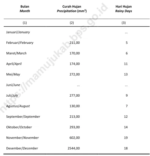
Curah hujan tertinggi di Kecamatan Karossa
selama 2018 terjadi di Bulan November sebanyak 602,00mm
3.
①
The highest precipitation in Karossa Subdistrict during 2018occured in
November which was 602.00 mm
3.
Sumber/Source:
1. BP3K Karossa/ Agriculture Fishery Forestry Counseling Office of Karossa
2. Badan Perencanaan Pembangunan dan dan Pengembangan Daerah Kabupaten MamujuTengah/ DevelopmentPlanning and Expansion Board of Mamuju Tengah Regency
GEOGRAFI DAN IKLIM
Kecamatan Karossa Dalam Angka 2019
|
3
PENJELASAN TEKNIS
1. Berdasarkan posisi geografisnya,
KecamatanKarossamemiliki
batas-batas: Utara –Kabupaten Mamuju
Utara; Selatan –Kecamatan Topoyo;
Barat –Selat Makassar; Timur –
Provinsi Sulawesi Selatan.
Kecamatan Karossa terdiri dari 13
Desa, yaitu:Desa Kambunong, Desa
Tasokko,Desa Salubiro, Desa Lara,
Desa Sukamaju, Desa Lembah
Hopo, UPT Lara III, Desa
Karossa,Desa Kayucalla,Desa
Kadaila,Desa Benggaulu,UPT Mora
IV dan Desa Sanjango.
2.
Desa tepi laut
adalah
desa/kelurahan yang memiliki
sebagian wilayah yang
bersinggungan/berbatasan lansung
dengan laut, baik berupa pantai
landau/datar maupun tebing
karang.
3.
Desa bukan tepi laut adalah
desa/kelurahan yang wilayahnya
tidak bersinggungan langsung
dengan laut.
TECHNICAL NOTES
1. In terms of geographic position,
KarossaSubdistrict has boundaries as
follows: North –
Mamuju
UtaraRegency; South –Topoyo
Subdistrict; West –Makassar Strait;
East –Sulawesi Selatan Province
.
Karossa Subdistrict has 13 villages.
These include: Kambunong
Village,Tasokko
Village,Salubiro
Village,Lara Village,Sukamaju Village,
Lembah Hopo Village, UPT Lara III,
Karossa Village,Kayucalla
Village,Kadaila Village,Benggaulu
Village, UPT Mora IV Village, and
Sanjango Village.
2.
Coastal Village is a village which has
some area that intersect/directly
adjacent to the sea, either gently
sloping/flat beach of cliffs/reef
3.
Non coastal village is a village which
has no area that intersect/directly
adjacent to the sea.
ULASAN
Geografi
Kecamatan Karossa memiliki wilayah
seluas 1.175,38 km
2yang secara
administratif terbagi ke dalam 13 desa.
Desa dengan wilayah paling luas wilayah
adalah Desa Karossa dengan luas
wilayah 328,60 km
2atau 27,96 persen
dari luas Kecamatan Karossa. Sementara
desa dengan wilayah paling sempit
adalah UPT Mora IV dengan luas wilayah
6,66 km
2atau 0,57 persen dari luas
wilayah Kecamatan Karossa.
Ibukota Kecamatan Karossa berada
di Desa Karossa. Desa yang terletak
paling jauh dari ibukota Kecamatan
Karossa adalah Desa Kambunong, yaitu
35 km. Jarak seluruh desa di Kecamatan
Karossa dari ibukota Kecamatan Karossa
dapat dilihat pada Tabel 1.1.2.
Iklim
Tingkat curah hujan di suatu tempat
dipengaruhi oleh keadaan iklim. Oleh
karena itu, curah hujan beragam
menurut bulan. Selama 2018 di
Kecamatan Karossa, tingkat curah hujan
tertinggi terjadi pada bulan Mei, yaitu
sebanyak 602 mm
3.
DESCRIPTION
Geography
Karossa Subdistrict has an area of
1,175.38km
2which is administratively
divided into 13 villages. Village with the
largest area is Karossa Village with an
area of 328.60 km
2or 27.96 percent of
the total area of Karossa Subdistrict.
While, village with the smallest area is
UPT Mora IV Village with an area of 6.66
km
2or 0.57 percent of the total area of
KarossaSubdistrict.
The capital of Karossa Subdistrict is
located at Karossa Village. The furthest
village from the capital of Karossa
Subdistrict is Kambunong Village, i.e. 35
km. The distance of all villages in
Karossa Subdistrict from the capital of
Karossa Subdistrict can be seen at Table
1.1.2.
Climate
Precipitation rate of a place is
influenced by climate. Therefore, the
volume of precipitation varied by month.
During 2018 in Karossa Subdistrict, the
highest volume of precipitation occurred
in May which was 602 mm
3.
GEOGRAFI DAN IKLIM
Kecamatan Karossa Dalam Angka 2019
|
5
Gambar 1 Persentase Luas Wilayah Menurut Desa di Kecamatan
Karossa, 2018
Percentage Area by Villagein Karossa Subdistrict,2018
Picture
Sumber/Source: Badan Perencanaan Pembangunan dan dan Pengembangan Daerah Kabupaten Mamuju Tengah/Development
Planning and Expansion Board of Mamuju Tengah Regency
14.41% 18.03% 11.26% 8.70% 7.61% 1.83% 1.08% 27.96% 0.82% 1.48% 1.21% 0.57% 5.05%
Kambunong
Tasokko
Salubiro
Lara
Suka Maju
Lembah Hopo
UPT Lara III
Karossa
Kayu Calla
Kadaila
Benggaulu
UPT Mora IV
Sanjango
Gambar 2 Jumlah Curah Hujan Menurut Bulan di Kecamatan Karossa
(mm
3), 2018
Amount of Precipitation by Month in Karossa Subdistrict
(mm
3), 2018
Picture
211 170 174 272 277 130 213 293 602 2,5440
500
1000
1500
2000
2500
3000
Fe br ua ri/ Fe br ua ry Mar et /Mar ch Ap ril /A pri l Me i/May Ju li/ Ju ly Ag ust us/ Au gu st Se pt em be r/ Se pt em be r Ok tob er /O ct ob er Nov em be r/ Nov em be r De se m be r/ De ce m be rCur
ah H
uj
an/
Pre
cip
ita
tio
n
(mm
3)
Bulan/Month
https://mamujukab.bps.go.id
GEOGRAFI DAN IKLIM
Kecamatan Karossa Dalam Angka 2019
|
7
1.1
G
EOGRAFI
/G
EOGRAPHY
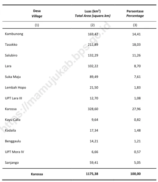
Tabel 1.1.1 Luas Wilayah Menurut Desa di Kecamatan Karossa, 2018
Total Area by Village in Karossa Subdistrict, 2018
Table
Desa
Village Luas (km
2)
Total Area (square.km) Percentage Persentase
(1) (2) (3) Kambunong 169,42 14,41 Tasokko 211,89 18,03 Salubiro 132,29 11,26 Lara 102,22 8,70 Suka Maju 89,49 7,61 Lembah Hopo 21,50 1,83
UPT Lara III 12,70 1,08
Karossa 328,60 27,96 Kayu Calla 9,64 0,82 Kadaila 17,34 1,48 Benggaulu 14,21 1,21 UPT Mora IV 6,66 0,57 Sanjango 59,41 5,05 Karossa 1175,38 100,00
Sumber/Source: Badan Perencanaan Pembangunan dan dan Pengembangan Daerah Kabupaten Mamuju Tengah/Development
Planning and Expansion Board of Mamuju Tengah Regency
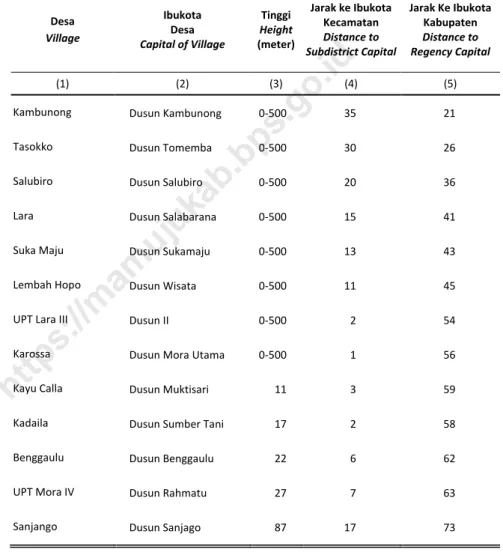
Tabel 1.1.2 Tinggi Wilayah di Atas Permukaan Laut (DPL) Menurut Desa
di Kecamatan Karossa, 2018
Height Above Mean Sea Level (AMSL) by Village in Karossa
Subdistrict, 2018
Table
Desa Village Ibukota Desa Capital of Village Tinggi Height (meter) Jarak ke Ibukota Kecamatan Distance to Subdistrict Capital Jarak Ke Ibukota Kabupaten Distance to Regency Capital (1) (2) (3) (4) (5)Kambunong Dusun Kambunong 0-500 35 21
Tasokko Dusun Tomemba 0-500 30 26
Salubiro Dusun Salubiro 0-500 20 36
Lara Dusun Salabarana 0-500 15 41
Suka Maju Dusun Sukamaju 0-500 13 43
Lembah Hopo Dusun Wisata 0-500 11 45
UPT Lara III Dusun II 0-500 2 54
Karossa Dusun Mora Utama 0-500 1 56
Kayu Calla Dusun Muktisari 11 3 59
Kadaila Dusun Sumber Tani 17 2 58
Benggaulu Dusun Benggaulu 22 6 62
UPT Mora IV Dusun Rahmatu 27 7 63
Sanjango Dusun Sanjago 87 17 73
Sumber/Source: Masing-masing Desa/Each Village
GEOGRAFI DAN IKLIM
Kecamatan Karossa Dalam Angka 2019
|
9
Tabel 1.1.3 Jarak AntarDesa di Kecamatan Karossa, 2018
Distance BetweenVillages in Karossa Subdistrict, 2018
Table
Desa Village Ka m bu no ng Ta so kko Sa lu bi ro La ra Su ka M aj u Le m ba h H opo UP T La ra II I Ka ro ss a Ka yu Ca lla Ka da ila Be ngga ul u UP T Mo ra IV Sa nj ang o (1) (2) (3) (4) (5) (6) (7) (8) (9) (10) (11) (12) (13) (14) Kambunong 0 5 22 20 48 24 33 35 38 37 41 42 55 Tasokko 5 0 15 10 27 19 28 30 33 32 36 37 47 Salubiro 22 15 0 5 7 9 18 20 23 22 26 27 37 Lara 20 10 5 0 2 4 13 15 18 17 21 22 35 Suka Maju 48 27 7 2 0 2 11 13 16 15 19 20 30 Lembah Hopo 24 19 9 4 2 0 9 11 14 13 17 18 31 UPT Lara III 33 28 18 13 11 9 0 2 5 4 9 10 19 Karossa 35 30 20 15 13 11 2 0 3 2 0 7 17 Kayu Calla 27 33 23 22 16 14 5 3 0 1 9 10 20 Kadaila 26 32 22 17 15 13 4 2 1 0 8 9 19 Benggaulu 41 36 26 21 19 17 9 6 9 8 0 1 23 UPT Mora IV 42 37 7 22 20 18 10 7 10 9 1 0 24 Sanjango 55 47 37 35 30 31 19 17 20 19 27 24 0 Sumber/Source: Masing-masing Desa/Each VillageTabel 1.1.4 Letak Geografis Menurut Desa di Kecamatan Karossa, 2018
Geographical Location by Village in Karossa Subdistrict, 2018
Table
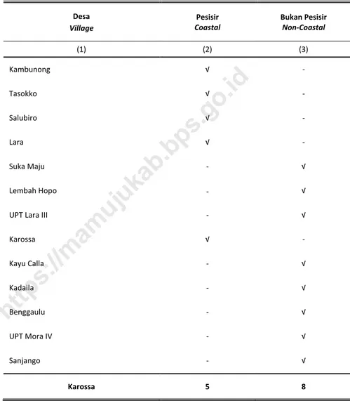
Desa
Village Coastal Pesisir Bukan Pesisir Non-Coastal
(1) (2) (3) Kambunong √ - Tasokko √ - Salubiro √ - Lara √ - Suka Maju - √ Lembah Hopo - √
UPT Lara III - √
Karossa √ - Kayu Calla - √ Kadaila - √ Benggaulu - √ UPT Mora IV - √ Sanjango - √ Karossa 5 8
Sumber/Source: Masing-masing Desa/Each Village
GEOGRAFI DAN IKLIM
Kecamatan Karossa Dalam Angka 2019
|
11
Tabel 1.1.5 Topografi Wilayah Menurut Desa di Kecamatan Karossa,
2018
Topographical Areas by Village in Karossa Subdistrict, 2018
Table
Desa
Village Daerah Datar Plain Area Daerah Berbukit Hilly Area
(1) (2) (3) Kambunong √ - Tasokko √ - Salubiro √ - Lara √ - Suka Maju - - Lembah Hopo - √
UPT Lara III - √
Karossa √ - Kayu Calla √ - Kadaila √ - Benggaulu √ - UPT Mora IV √ - Sanjango - √ Karossa 10 3
Sumber/Source: Masing-masing Desa/Each Village
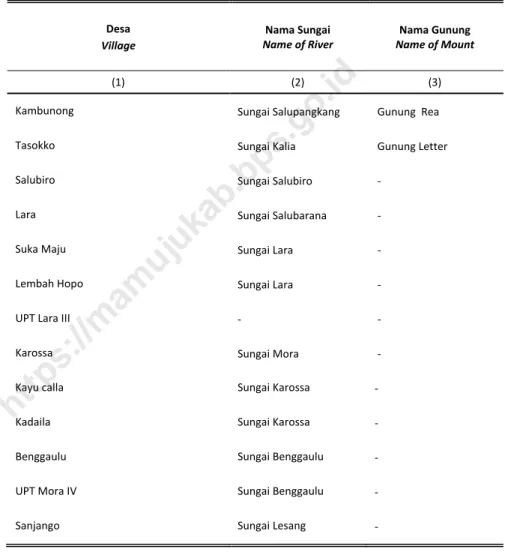
Tabel 1.1.6 Nama Sungai yang Melintas dan Gunung Menurut Desa di
Kecamatan Karossa, 2018
Name of Across River and Mount by Village in Karossa
Subdistrict, 2018
Table
Desa
Village Name of River Nama Sungai Name of Mount Nama Gunung
(1) (2) (3)
Kambunong Sungai Salupangkang Gunung Rea
Tasokko Sungai Kalia Gunung Letter
Salubiro Sungai Salubiro -
Lara Sungai Salubarana -
Suka Maju Sungai Lara -
Lembah Hopo Sungai Lara -
UPT Lara III - -
Karossa Sungai Mora -
Kayu calla Sungai Karossa -
Kadaila Sungai Karossa -
Benggaulu Sungai Benggaulu -
UPT Mora IV Sungai Benggaulu -
Sanjango Sungai Lesang -
Sumber/Source: Masing-masing Desa/Each Village
GEOGRAFI DAN IKLIM
Kecamatan Karossa Dalam Angka 2019
|
13
1.2
I
KLIM
/C
LIMATE
Tabel 1.2.1 JumlahCurah Hujan danHari Hujan Menurut Bulan di
Kecamatan Karossa, 2018
Amount ofPrecipitation and Number of Rainy Days by
Month in Karossa Subdistrict, 2018
Table
Bulan
Month Precipitation (mmCurah Hujan 3) Rainy Days Hari Hujan
(1) (2) (3) Januari/January ... ... Februari/February 211,00 5 Maret/March 170,00 6 April/April 174,00 11 Mei/May 272,00 13 Juni/June ... ... Juli/July 277,00 9 Agustus/August 130,00 7 September/September 213,00 12 Oktober/October 293,00 14 November/November 602,00 19 Desember/December 2544,00 18
Sumber/Source: BP3K Karossa/ Agriculture Fishery Forestry Counseling Office of Karossa
https://mamujukab.bps.go.id
PEMERINTAHAN
Kecamatan Karossa Dalam Angka 2019
|
15
2
PEMERINTAHAN
GOVERNMENT
54
Orang/persons
77
Orang/persons
Jumlah PNS yang bertugas di Kecamatan Karossa, 2018
Number of Civil Servant who work in Karossa Subdistrict, 2018
Sumber/Source: Masing-masing Instansi di Kecamatan Karossa
/each instance in Subdistrict Karossa
PEMERINTAHAN
Kecamatan Karossa Dalam Angka 2019
|
17
PENJELASAN TEKNIS
1. Satuan lingkungan setempat di
bawah desa/kelurahan adalah
dusun/lingkungan, Rukun Warga
(RW), dan Rukun Tetangga (RT).
2. Desa atau yang disebut dengan
nama lain (selanjutnya disebut
sebagai desa) adalah kesatuan
masyarakat hukum yang memiliki
bata-batas wilayah dan berwenang
untuk mengatur dan mengurus
kepentingan masyarakat setempat
berdasarkan asal-usul dan adat
istiadat setempat yang diakui dan
dihormati
dalam Sistem
Pemerintahan Negara Kesatuan
Republik Indonesia (UU No. 32
Tahun 2004). Kepala desa dipilih
secara langsung oleh masyarakat di
desa tersebut
3. Kelurahan adalah suatu wilayah
yang dipimpin oleh lurah sebagai
perangkat daerah kabupaten dan
atau daerah kota di bawah
kecamatan (UU No. 32 Tahun
2004). Lurah diangkat oleh
Bupati/Walikota.
4. Tingkat Perkembangan Desa dan
Kelurahan adalah status tertentu
dari capaian hasil kegiatan
pembangunan yang dapat
TECHNICAL NOTES
1. The units of local environment in the
bottom of the village are subvillage,
people association, neighbourhood
association.
2. Village or that is called by another
terms (hereinafter referred to as
village) is the unity of the legal
community who have territorial
boundaries and the authority to
regulate and manage the interests
of local communities based on the
origin and local customs that are
acknowledged abd respected
within the Unitary System of
Government Republic of Indonesia
(Law No. 32 Year 2004). The village
head is directly elected by the
people in the village.
3. Kelurahan is an area that is led by a
village chief (Lurah) as an
apparatus of regency and or city
under the district (Law No. 32 Year
2004). Lurah appointed by the
Regent/Mayor.
4.
Villages Development Level is a
certain status of the achievements
of development activities to reflect
the level of progress and/or success
mencerminkan tingkat kemajuan
dan/atau keberhasilan masyarakat,
pemerintahan desa dan kelurahan
serta pemerintahan daerah dalam
melaksanakan pembangunan di
desa dan kelurahan.
of the community, village
government and regional
government in implementing
village development.
PEMERINTAHAN
Kecamatan Karossa Dalam Angka 2019
|
19
ULASAN
Pada tahun 2018, Kecamatan
Karossa terdiri atas 11 desa, 2 Unit
Pemukiman Transmigrasi(UPT) dan 75
dusun.
Dalam pelaksanaan tugas-tugas
pemerintahan pada tingkat kecamatan,
pegawai negeri sipil yang bertugas di
kecamatan ini sejumlah 111orang yang
tersebar pada beberapa instansi tingkat
kecamatan.
DESCRIPTION
In 2018, Karossa Subdistrict
consisted of 11
villages, 2
Transmigration Settlement Unit and 75
sub villages.
In the execution of tasks of
government at the subdistrict level, the
civil servantwho worked in this
subdistrict reached 111people spread on
some subdistrict level institution.
Gambar 3 Jumlah Dusun Menurut Desa di Kecamatan Karossa,
2018
Number ofSubvillage by Village In Karossa
Subdistrict,2018
Picture
6 11 4 5 5 5 4 12 3 4 7 4 4 Kambunong Tasokko Salubiro Lara Suka Maju Lembah Hopo UPT Lara III Karossa Kayu calla Kadaila Benggaulu UPT Mora IV Sanjango 0 2 4 6 8 10 12 14https://mamujukab.bps.go.id
PEMERINTAHAN
Kecamatan Karossa Dalam Angka 2019
|
21
2.1
W
ILAYAH
A
DMINISTRATIF
/A
DMINISTRATIVE
A
REA
Tabel 2.1.1 KlasifikasiPemerintahan Wilayah Administrasi di Kecamatan
Karossa, 2018
GovernmentalClassification of Administrative Area in
Karossa Subdistrict, 2018
Table
Desa
Village Village Desa Kelurahan Kelurahan
Unit Pemukiman Transmigrasi Transmigration Settlement Unit (1) (2) (3) (4) Kambunong √ - - Tasokko √ - - Salubiro √ - - Lara √ - - Suka Maju √ - - Lembah Hopo √ - -
UPT Lara III
-
- √Karossa √ - - Kayu calla √ - - Kadaila √ - - Benggaulu √ - - UPT Mora IV - - √ Sanjango √ - - Karossa 11 - 2
Sumber/Source: Kantor CamatKarossa/KarossaSubdistrict Office
Tabel 2.1.2 Banyaknya Lingkungan, Dusun, Rukun Warga (RW) dan
Rukun Tetangga (RT) Menurut Desa di Kecamatan Karossa,
2018
Number of Sub Village,People Association, and
Neighbourhood Association by Village in Karossa
Subdistrict, 2018
Table
Desa
Village Lingkungan Sub Village Sub Village Dusun
Rukun Warga People Association Rukun Tetangga Neighbourhood Association (1) (2) (3) (4) (5) Kambunong - 6 - 13 Tasokko - 11 - 19 Salubiro - 4 - 8 Lara - 5 - 10 Suka Maju - 5 - 11 Lembah Hopo - 5 - 9
UPT Lara III - 4 - 6
Karossa - 12 - 29 Kayu calla - 3 - 10 Kadaila - 4 - 14 Benggaulu - 7 - 15 UPT Mora IV - 4 - 7 Sanjango - 4 - 8 Karossa - 74 - 159
https://mamujukab.bps.go.id
PEMERINTAHAN
Kecamatan Karossa Dalam Angka 2019
|
23
2.2
P
EGAWAI
N
EGERI
S
IPIL
/C
IVIL
S
ERVANTS
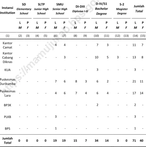
Tabel 2.2.1 Jumlah Pegawai Negeri Sipil Menurut Instansi, Pendidikan
Tertinggi yang Ditamatkan, dan Jenis Kelamin di Kecamatan
Karossa, 2018
Number of Civil Servants by Institution, Educational
Attainment, and Sex in Karossa Subdistrict, 2018
Table
Instansi Institution
Pendidikan Tertinggi/Educational Attainment SD Elementary School SLTP Junior High School SMU Senior High School DI-DIII Diploma I-III D-IV/S1 Bachelor Degree S-2 Magister Degree Jumlah Total L M P F L M P F L M P F L M P F L M P F L M P F L M P F (1) (2) (3) (4) (5) (6) (7) (8) (9) (10) (11) (12) (13) (14) (15) Kantor Camat - - - - 4 4 - - 7 3 - - 11 7 Kantor Cabang Diknas - - - 3 - - 10 5 3 - 13 8 KUA - - - 3 - - - 3 - Puskesmas Durikumba - - - - 7 6 8 3 6 2 - - 21 11 Puskesmas Lara - - - - 4 6 7 4 6 4 - - 17 14 BP3K - - - 2 - - - 2 - PLKB - - - - 3 - - - 3 - BPS - - - - 1 - - - 1 - Jumlah Total 0 0 0 0 19 19 15 7 34 14 3 0 71 40
Sumber/Source: Masing-masing Instansi/Each Instance
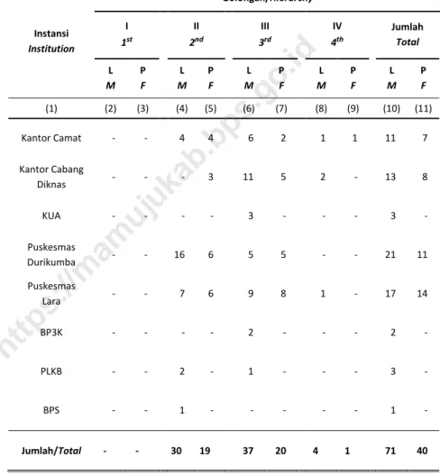
Tabel 2.2.2 Jumlah Pegawai Negeri Sipil Menurut Instansi, Golongan,
dan Jenis Kelamin di Kecamatan Karossa, 2018
Number of Civil Servants by Institution, Hierarchy, and Sex in
Karossa Subdistrict, 2018
Table
Instansi Institution Golongan/Hierarchy I1st 2II nd 3III rd 4IV th Jumlah Total
L M P F L M P F M L P F M L P F L M P F (1) (2) (3) (4) (5) (6) (7) (8) (9) (10) (11) Kantor Camat - - 4 4 6 2 1 1 11 7 Kantor Cabang Diknas - - - 3 11 5 2 - 13 8 KUA - - - - 3 - - - 3 - Puskesmas Durikumba - - 16 6 5 5 - - 21 11 Puskesmas Lara - - 7 6 9 8 1 - 17 14 BP3K - - - - 2 - - - 2 - PLKB - - 2 - 1 - - - 3 - BPS - - 1 - - - 1 - Jumlah/Total - - 30 19 37 20 4 1 71 40
Sumber/Source: Masing-masing Instansi/Each Instance
KEPENDUDUKAN
Kecamatan Karossa Dalam Angka 2019
|
25
3
KEPENDUDUKAN
POPULATION
13.514
jiwa/persons
jiwa/persons
12.821
51,31 %
48,68 %
Jumlah Penduduk Kecamatan Karossapada tahun 2018 mencapai
26.335
jiwa.
Population of Karossa Subdistrict in 2018 reached 26,335 persons.
Kepadatanpenduduk Kecamatan Karossa
pada Tahun 2018 mencapai
22,40
jiwa/km
2.
Population density of Karossa Subdistrict in 2018
reached 21.40 persons/km
2.Sumber/Source: Proyeksi Penduduk Indonesia 2010–2035/Indonesia Population Projection 2010–2035
https://mamujukab.bps.go.id
KEPENDUDUKAN
Kecamatan Karossa Dalam Angka 2019
|
27
PENJELASAN TEKNIS
5. Sumber utama data kependudukan
adalah sensus penduduk yang
dilaksanakan setiap sepuluh tahun
sekali. Sensus penduduk telah
dilaksanakan sebanyak enam kali
sejak Indonesia merdeka, yaitu
tahun 1961, 1971, 1980, 1990, 2000,
dan 2010.
Di dalam sensus penduduk,
pencacahan dilakukan terhadap
seluruh penduduk yang berdomisili
di wilayah teritorial Indonesia
termasuk warga negara asing
kecuali anggota korps diplomatik
negara sahabat beserta
keluarganya.
Metode pengumpulan data dalam
sensus
dilakukan dengan
wawancara antara petugas sensus
dengan responden dan juga melalui
e-census
. Pencatatan penduduk
menggunakan konsep usual
residence, yaitu konsep di mana
penduduk biasa bertempat tinggal.
Bagi penduduk yang bertempat
tinggal tetap dicacah di mana
mereka biasa tinggal, sedangkan
untuk penduduk yang tidak
bertempat tinggal tetap dicacah di
tempat di mana mereka ditemukan
petugas sensus pada malam ‘Hari
Sensus’. Termasuk penduduk yang
tidak bertempat tinggal tetap adalah
TECHNICAL NOTES
5. The main source of demographic
data is population census, which is
conducted every ten years.
Population Census has been
conducted six times since
Indonesia’s independence: 1961,
1971, 1980, 1990, 2000, and 2010.
The population census enumerates
all residents who domicile in the
entire territory of Indonesia
including foreign citizens except the
diplomatic corps members and
their families.
The method of data collection in a
population census involves
interviewing respondents and
conducting e-census. Enumeration
of the population uses the concept
of “usual residence”, which is the
concept of “places where people
usually live”. De jure was applied to
the permanent residents, while de
facto was applied to
non-permanent residents. The
permanent residents were
enumerated in place where they
normally live, the non-permanent
residents were enumerated where
they were found by the
enumerators, on the night of
‘Census Date’. The non permanent
residents include homeless people,
ship crew, boat people, remote
tuna wisma, awak kapal berbendera
Indonesia, penghuni perahu/rumah
apung, masyarakat
terpencil/terasing, dan pengungsi.
Bagi mereka yang mempunyai
tempat tinggal tetap dan sedang
bepergian ke luar wilayah lebih dari
enam bulan, tidak dicacah di tempat
tinggalnya, tetapi dicacah di tempat
tujuannya. Untuk tahun yang tidak
dilaksanakan sensus penduduk, data
kependudukan diperoleh dari hasil
proyeksi penduduk. Proyeksi
penduduk merupakan suatu
perhitungan ilmiah yang didasarkan
pada asumsi dari
komponen-komponen perubahan penduduk,
yaitu kelahiran, kematian, dan
migrasi. Proyeksi penduduk
Indonesia 2010–2035 menggunakan
data dasar penduduk hasil SP2010.
6.
Penduduk Indonesia adalah semua
orang yang berdomisili di wilayah
teritorial Indonesia selama 6 bulan
atau lebih dan atau mereka yang
berdomisili kurang dari 6 bulan
tetapi bertujuan menetap.
7.
Laju pertumbuhan pendudukadalah
angka yang menunjukkan
persentase pertambahan penduduk
area community, and internally
displaced persons. Those who had
permanent residence and had been
travelling away from their home for
six months or more were not
enumerated in their permanent
place, but in the place where they
were during the census.
For the periods where the
population census is not conducted,
population projection is done to
estimate population during those
years. The population projection is
an estimate based on the
demographic components, such as
birth, death, and migration.
Indonesia’s 2010–2035 population
projection used the 2010
Population Census as the base
population.
6.
The population of Indonesia are all
residents of the entire territory of
Indonesia who have stayed for six
months or longer, and those who
intended to stay more than six
months even though their length of
stay is less than six months.
7. The growth rate of population is
the number that show percentage
of population growth within a
KEPENDUDUKAN
Kecamatan Karossa Dalam Angka 2019
|
29
8.
Kepadatan penduduk adalah rasio
banyaknya penduduk per kilometer
persegi.
9.
Rasio jenis kelamin adalah
perbandingan antara penduduk
laki-laki dan penduduk perempuan pada
suatu wilayah dan waktu tertentu.
Biasanya dinyatakan dengan
banyaknya penduduk laki-laki untuk
100 penduduk perempuan.
10.
Distribusi penduduk adalah pola
persebaran penduduk di suatu
wilayah, baik berdasarkan
batas-batas geografis maupun
berdasarkan batas-batas
administrasi pemerintahan.
11.
Komposisi penduduk adalah pola
persebaran penduduk menurut
karakteristiknya, contoh: penduduk
menurut kelompok umur, penduduk
menurut jenis kelamin
12.
Rumah tangga adalah seseorang
atau sekelompok orang yang
mendiami sebagian atau seluruh
bangunan fisik/sensus dan biasanya
tinggal bersama serta pengelolaan
makan dari satu dapur. Yang
dimaksud makan dari satu dapur
adalah jika pengurusan kebutuhan
sehari-harinya dikelola
bersama-sama menjadi satu.
8.
Population density is ratio of
population per square kilometer.
9.
Sex ratio is the ratio of males
population to females population
in a given area and time, usually
expressed as the number of males
for every 100 females.
10.
Population distribution is the
pattern of population distribution
in an area, either by geographic
boundaries or by government
administrative boundaries.
11.
Population compotition isthe
pattern of population distribution
by its characteristics, example:
population by age group,
population by sex
12.
Household is an individual or group
of people living in a physical/census
building unit or part of it and
usually commit on a common
provision for food and other
essentials of living. Common
provision for food means one
organising daily needs for all of
household members.
13.
Anggota rumah tangga adalah
semua orang yang biasanya
bertempat tinggal di suatu rumah
tangga, baik yang berada di rumah
pada waktu pencacahan maupun
yang sementara tidak ada.
14.
Rata-rata anggota rumah tangga
adalah angka yang menunjukkan
rata-rata jumlah anggota rumah
tangga per rumah tangga.
13.
Household member are those who
usually lives in a household
regardless of their location at the
time of enumeration.
14.
Average household size is the
average number of household
members per household.
KEPENDUDUKAN
Kecamatan Karossa Dalam Angka 2019
|
31
ULASAN
Data penduduk tahun 2018 yang
disajikan pada Tabel 3.1 adalah angka
estimasi penduduk yang dihitung
berdasarkan proyeksi penduduk. Jumlah
penduduk Kecamatan Karossa
berdasarkan proyeksi penduduk tahun
2018 adalah 26.335 jiwa yang terdiri
atas 13.514 jiwa penduduk laki-laki dan
12.821 jiwa penduduk perempuan.
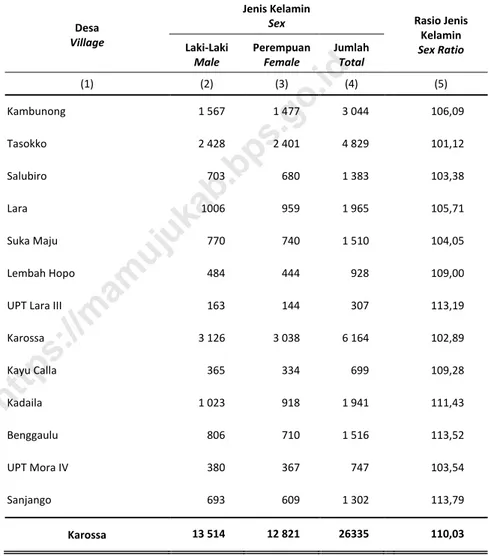
Sementara itu, besarnya angka rasio
jenis kelamin tahun 2018 penduduk
laki-laki terhadap penduduk perempuan
sebesar 105,40
Kepadatan penduduk di Kecamatan
Karossa tahun 2018 mencapai 22,40
jiwa/km
2dengan rata-rata jumlah
penduduk per rumah tangga 4,60 orang.
Kepadatan penduduk di 13 desa cukup
beragam dengan kepadatan penduduk
tertinggi terjadi di Kadaila dengan
kepadatan sebesar 119,93 jiwa/km
2dan
terendah terjadi di Desa Salibiro sebesar
10,43 jiwa/Km
2.
DESCRIPTION
Population data presented in Table
3.1 are the estimation figure which were
calculated based on population
projection. Total population of Karossa
Subdistrictin 2018 was 26,335 people
which consist of 13,514 people of male
and 12,82 people of female While, the
value of the sex ratio in 2018 the male
population compares to the female
population was105.40.
Population density of Karossa
Subdistrict in 2018 reached 22.40
people/km
2with the average number of
residents per household are 4.60 people.
Population density in 13 village are quite
diverse with the highest population
density of villageoccured in the Kadaila
Village with the number of density are
119,93 people/km
2and the lowest
population density village occurredin
Salubiro Village with 10.43 people/km
2.
https://mamujukab.bps.go.id
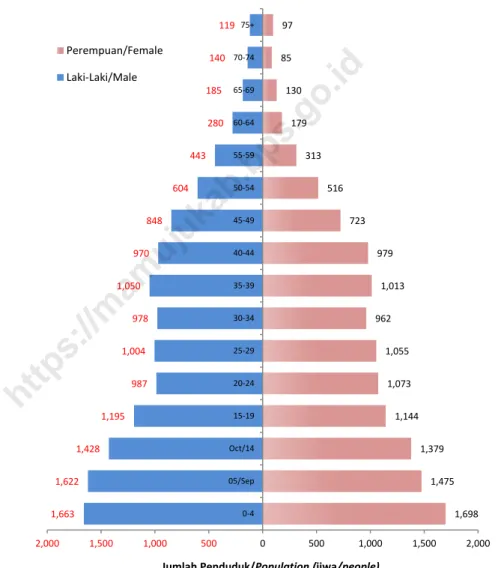
Gambar 4 Jumlah Penduduk Menurut Kelompok Umur dan Jenis
Kelamin di Kecamatan Karossa, 2017
Population by Age Group and Sex in Karossa
Subdistrict, 2017
Picture
1,663 1,622 1,428 1,195 987 1,004 978 1,050 970 848 604 443 280 185 140 119 1,698 1,475 1,379 1,144 1,073 1,055 962 1,013 979 723 516 313 179 130 85 97 2,000 1,500 1,000 500 0 500 1,000 1,500 2,000 0-4 05/Sep Oct/14 15-19 20-24 25-29 30-34 35-39 40-44 45-49 50-54 55-59 60-64 65-69 70-74 75+Jumlah Penduduk/Population (jiwa/people)
Perempuan/Female Laki-Laki/Male
KEPENDUDUKAN
Kecamatan Karossa Dalam Angka 2019
|
33
Tabel 3.1.1 Jumlah Penduduk Menurut Desa di KecamatanKarossa
2010, 2016, dan 2018
Population by Village in Karossa Subdistrict, 2010, 2016,
and 2018
Table
Desa Village Jumlah Penduduk/Population 2010 2017 2018 (1) (2) (3) (4) Kambunong 2 545 2 982 3 044 Tasokko 4 034 4 729 4 829 Salubiro 1 155 1 354 1 383 Lara 1 641 1 924 1 965 Suka Maju 1 262 1 479 1 510 Lembah Hopo 776 909 928UPT Lara III 258 301 307
Karossa 5 149 5 037 6 164 Kayu Calla 584 685 699 Kadaila 1 622 1 901 1 941 Benggaulu 1 265 1 484 1 516 UPT Mora IV 624 732 747 Sanjango 1 089 1 276 1 302 Karossa 22 004 25 793 26 335
Sumber/Source: Proyeksi Penduduk Indonesia 2010–2035/Indonesia Population Projection 2010–2035
https://mamujukab.bps.go.id
Tabel 3.1.2 Jumlah Penduduk dan Rasio Jenis Kelamin Menurut Desa
di KecamatanKarossa, 2018
Number of Population and Sex Ratio by Village in
KarossaSubdistrict, 2018
Table
Desa Village
Jenis Kelamin
Sex Rasio Jenis
Kelamin Sex Ratio Laki-Laki
Male Perempuan Female Jumlah Total
(1) (2) (3) (4) (5) Kambunong 1 567 1 477 3 044 106,09 Tasokko 2 428 2 401 4 829 101,12 Salubiro 703 680 1 383 103,38 Lara 1006 959 1 965 105,71 Suka Maju 770 740 1 510 104,05 Lembah Hopo 484 444 928 109,00
UPT Lara III 163 144 307 113,19
Karossa 3 126 3 038 6 164 102,89 Kayu Calla 365 334 699 109,28 Kadaila 1 023 918 1 941 111,43 Benggaulu 806 710 1 516 113,52 UPT Mora IV 380 367 747 103,54 Sanjango 693 609 1 302 113,79 Karossa 13 514 12 821 26335 110,03
Sumber/Source: Proyeksi Penduduk Indonesia 2010–2035/Indonesia Population Projection 2010–2035