Land quality indicators: research plan
J. Dumanski
a,∗, C. Pieri
ba16 Burnbank Street, Ottawa, Canada K2G 0H4 bRural Development Sector, World Bank, Washington, DC, USA
Abstract
Indicators of land quality (LQIs) are being developed as a means to better coordinate actions on land related issues, such as land degradation. Economic and social indicators are already in regular use to support decision making at global, national and sub-national levels and in some cases for air and water quality, but few such indicators are available to assess, monitor and evaluate changes in the quality of land resources. Land refers not just to soil but to the combined resources of terrain, water, soil and biotic resources that provide the basis for land use. Land quality refers to the condition of land relative to the requirements of land use, including agricultural production, forestry, conservation, and environmental management.
The LQI program addresses the dual objectives of environmental monitoring as well as sector performance monitoring for managed ecosystems (agriculture, forestry, conservation and environmental management). The primary research issue in the LQI program is the development of indicators that identify and characterize the impact(s) of human interventions on the landscape for the major agroecological zones of tropical, sub-tropical and temperate environments. Core LQIs identified for immediate development are: nutrient balance, yield gap, land use intensity and diversity, and land cover; LQIs requiring longer term research include: soil quality, land degradation, and agro-biodiversity; LQIs being developed by other authoritative groups include: water quality, forestland quality, rangeland quality, and land contamination/pollution. © 2000 Elsevier Science B.V. All rights reserved.
Keywords: Land quality; Land use; Land management; Land degradation; Monitoring
1. Introduction
The impacts of human interventions on natural sys-tems are increasingly critical issues for the future. In-creasing population pressures and inIn-creasing demands for services from a fixed land base are threatening the quality and the natural regulating functions of the soil, water and air resources on which sustainability depends. For the first time in history, we are crossing the threshold of new lands available for cultivation.
∗Corresponding author.
E-mail address: [email protected] (J. Dumanski).
For the first time, the sustainable management of the land resource is more important than land supply for development. However, land degradation and misman-agement are threatening our opportunities and flexi-bility for increased services from the land, requiring increased investment in soil conservation and even re-habilitation and reclamation. Estimates are that about 40% of agricultural lands are affected by human in-duced land degradation (Oldeman et al., 1990). The land quality indicators (LQIs) program is being devel-oped to expand our knowledge and understanding on land management and degradation problems in man-aged ecosystems, and to provide guidance to decision
makers on these issues. It is important to know if cur-rent land management is leading towards or away from sustainability.
Sustainable land management and the choice of feasible and cost effective management options is hampered by the lack of available indicators for mon-itoring how land is being managed by farmers, the impacts of policies and programs on land manage-ment choices at the farm level, and the impacts of different management scenarios (cause-effect rela-tionships) on land quality. As illustrated in the World Bank Action Plan, ‘From Vision to Action in the Rural Sector’ (World Bank, 1997a), there is clearly a major requirement at national and global levels for increased agricultural production and intensification, but the challenge is to achieve this while maintaining and enhancing the quality of the land resource on which production depends. This implies the need for standards, such as LQIs, on which to measure and assess progress towards these goals.
Indicators are common instruments for monitoring progress towards some larger objectives. For exam-ple, economic indicators, such as GDP, distribution of employment, etc., are used regularly to monitor per-formance of national and local economies. Similarly, access to social services, literacy rates, etc., are used for comparative assessments of social development. On the environmental side, indicators are available for monitoring and reporting on air and water quality (for which the World Bank played major catalytic roles). However, indicators which can be used to monitor change in land quality are still not available, and be-cause we cannot monitor land quality, we are not in a strong position to take appropriate action on land related issues such as land degradation (A. Young, personal communication).
Agriculture is traditionally viewed as an environ-mental problem, but if carefully managed, it can also be a significant part of the environmental solution. However, monitoring the impacts of agriculture on the environment is much more difficult than monitoring other sectors. Hundreds of millions of private farmers, large and small and male and female, are stewards of the globe’s land resources, and monitoring the impacts of their land use decisions is a major under-taking. Although, the impacts of any one individual is minuscule, the collective impacts of the millions of management decisions can have major regional and
even global environmental impacts. For example, lack of soil cover results in erosion and siltation of reser-voirs; loss of soil organic matter through land degra-dation contributes significantly to CO2 emissions to
the atmosphere; mismanagement of irrigated lands results in salinization and water logging. Currently, our procedures for monitoring the extent and im-pacts of these processes are rudimentary, and greatly hampered by the lack of appropriate indicators, the right kinds of data, and cost-effective monitoring methods.
This paper reports on the background, criteria, and research plan for a set of indicators for monitoring land quality. These evolved from a collaborative pro-gram being developed and implemented by a coalition consisting of the World Bank, the Food and Agricul-ture Organization of the United Nations (FAO), the United Nations Environment Program (UNEP), the United Nations Development Program (UNDP) and the Consultative Group on International Agricultural Research (CGIAR). The program addresses the dual objectives of environmental monitoring as well as sec-tor performance monisec-toring for managed ecosystems (agriculture and forestry). The objective of the paper is to provide guidance and to focus the research on LQIs.
In the context of LQIs, land quality is the condition of land relative to the requirements of land use, includ-ing agricultural production, forestry, conservation, and environmental management (Pieri et al., 1995). Land is an area of the earth’s surface, including all elements of the physical and biological environment that influ-ence land use. Land refers not only to soil, but also to landforms, climate, hydrology, vegetation and fauna, together with land improvements, such as terraces and drainage works (Sombroek and Sims, 1995).
2. Research requirements for the LQI program
ecoregions as the basis for geographically stratifying major land related issues. An AEZ is a spatial (land-scape) unit for identification and application of re-source management options to address specific issues. It is derived from geo-referenced biophysical and socio-economic information, and it is dynamic and multiscale in that it reflects human interventions in the landscape. The meetings also began the difficult pro-cess of selecting sets of quantifiable and comparable indicators to be used internationally to evaluate the impacts of human interventions in important AEZs in tropical, sub-tropical and temperate zones.
The research plan was developed during a research planning meeting, 21–22 October 1996, Washington, DC, sponsored by the World Bank. A panel of in-ternationally acclaimed scientists and administrators established research priorities and a recommended research plan, defined strategic alliances to be devel-oped with existing programs to achieve the research, and identified potential sources of funding. This plan has since been discussed and generally accepted at various national and international meetings.
A short and longer-term research plan was recom-mended involving a set of five core LQIs to be initi-ated in the short term as international reference stan-dards. A second set of three indicators for national and sub-national (project level) monitoring and evalu-ation was recommended for development over a longer time period. A third set of four LQIs was recognized, but development was recommended by liaison with authoritative institutions already involved in building these indicators.
2.1. Selecting the right (Core) LQIs
Interest in environmental monitoring has spawned a virtual indicator development industry in the recent past. Very often such indicators have been developed by ‘a priori’ identification of candidate indicators by a panel of experts, followed by assembling and ana-lyzing whatever data are available to support this se-lection. The success of this approach has been mixed, since often the final indicator has to be molded to fit the data available, and to reflect experiences gained in developing the indicator. Consequently, there is a strong possibility of bias in development of the indi-cator(s), and the final product is often somewhat less than what was intended or desired at the outset.
The LQI program takes an alternative approach. Experience has shown that truly robust indicators are developed first of all through comprehensive analyses of the complex systems to be described and monitored. It is only through such thorough and comprehensive analyses that sufficient understanding of a system is developed to ensure indicators that are simple and use-ful enough to be used at national and international levels.
The program will have to deal with the important questions of how to integrate socio-economic (land management) data with biophysical information in the definition and development of LQIs, and how to scale and aggregate indicators from local to regional, na-tional and global scales. Equally important, the indi-cators will have to be based on data that are either available or easily assembled, but they will still have to sufficiently reliable and robust to stand up under scientific scrutiny.
Land quality should be assessed for specific types of land use and management and for specific AEZs conditions in a country. Otherwise, trends and perfor-mance cannot be sensibly monitored, interpreted, and reported. This requires the development and applica-tion of spatially located and (normally) geo-referenced temporal data bases of the variables to be used to de-velop the LQIs. Such data bases are dede-veloped through spatial integration over time of the socio-economic and biophysical data for the different AEZs of a coun-try. However, census data and other primary data for land management, and AEZ boundaries normally do not coincide, and except for very small countries, most countries are made of several AEZs. Therefore, pro-cedures of spatial integration are necessary, but these must follow recognized protocols, such as described for Hierarchy Theory (Dumanski et al., 1998), and some criteria of correspondence between the different data bases must be applied (the 70% spatial coverage rule is often used, whereby it is assumed that the lo-cal socio-economic and biophysilo-cal data are directly related if the spatial coverage of the two sources of data are 70% or higher).
develop, model, test and refine the LQIs (Pieri et al., 1995; World Bank, 1997b). This normally will result in a small, select group of LQIs that relate closely to the (normally limited) AEZs in a given country. When the LQIs are developed and interpreted, they can either be reported by the AEZs, or the results can be aggregated to sub-national and national levels by weighting the LQIs according to their contribution towards some national objectives, such as calculating national wealth, rural poverty reduction, achieving food security, etc.
2.2. Objectives for the LQI research program
Major gaps in knowledge on the impacts of human interventions in the landscape were identified in the various international workshops leading to develop-ment of the LQI research plan. These are:
• links between land quality and poverty;
• links between land quality and land management,
i.e. management practices currently being used by farmers;
• lack of geo-referenced land management
informa-tion;
• lack of time series data and system resilience
infor-mation;
• rural-urban land management and land use planning
interactions;
• impacts of macro-level policies on land decisions
and land quality.
While all the knowledge gaps are important, the first three are the highest priorities, and these are the basis for the research program. This results in development of the following research objective:
“Identifying and testing cause-effect relationships among land quality, land management, and poverty is the primary research objective for the LQI program.”
3. Details of the proposed research program
A minimal number of recommended Core LQIs were identified using criteria and guidelines from ear-lier workshops (Dumanski, 1994; OECD, SCOPE and other indicator initiatives, and from the regional LQI workshops held in 1995 and 1996 in Cali, Nairobi, Rome and Washington). Emphasis was on making
better use of available data and information, and integrating these with new information management technologies such as remote sensing, geographic information systems (GIS), relational data base man-agement systems, the internet, etc.
The Core LQIs may be developed from direct mea-surement (remote sensing, census, etc), or estimated using well tested, scientifically sound procedures. Emphasis should be on analyses to identify driving force(s) of land use change and the impact(s) of the change. Interpretation of the LQIs should not be done in isolation, but within the context of what is happen-ing with land management/land use in the countries in question. Recommended contextual information to assist in interpretation of the LQIs include social and institutional information (tenure, gender, educational levels, etc), farm household economics , climate, and land use as available from the census.
Characteristics of Core LQIs are:
• measurable in space, i.e. over the landscape and in
all countries;
• reflect change over recognizable time periods (5–10
years);
• are a function of independent variables;
• are quantifiable and usually dimensionless (ratio
es-timates).
3.1. Core LQIs recommended for short term development
This section provides short descriptions and the cri-teria for each of the core LQIs being recommended. The major research issues are identified, along with some information on data sources and procedures for assessment and interpretation. The first two LQIs are already developed, and full instructions are available on: www.ciesin.org
3.1.1. Nutrient balance (and nutrient depletion)
This LQI describes nutrient stocks and flows as re-lated to different land management systems in specific AEZs and specific countries. It is based on several years of research and experience in East Africa and Europe (Smaling et al., 1996).
The major research issue is nutrient cycling:
• nutrient mining, nutrient imbalance and
primar-ily in developing countries with low rates of fertil-izer use;
• nutrient loading and environmental degradation
(phosphorus, nitrates, etc) caused by excess fertil-izer and manure application in developed countries, but increasingly also in developing countries with high fertilizer subsidies such as China.
The research process is similar to environmental ac-counting. It involves establishment of nutrient balance sheets with losses and additions as estimated from nutrient removal through crop harvesting, erosion, etc., compared to nutrient additions due to fertilizers, organic inputs, recharging of the nutrient supply due to legume rotations, deep rooting systems, natural recharging due to atmospheric fixation, etc. Smaling et al. (1996) have demonstrated how this LQI can be developed for several hierarchical scales, including the farm level, region (AEZ) level, and national level. Actual measurements of nutrient cycling are rarely available, but Smaling et al. (1996) have demonstrated that reliable estimates of nutrient balance can be devel-oped using crop yield statistics from national census, nutrient additions from fertilizer trade statistics, and various biophysical models for denitrification, leach-ing, erosion, etc;
3.1.2. Yield gap
Three closely related statistics are proposed for this issue:
• yield trends (direction, rate of change) for the major
food crops in specific AEZs;
• production risk (change in the expected annual
vari-ability in yield) for the major food crops in specific AEZs;
• yield gap (current yields compared to potential farm
level, economically feasible yields) for the major food crops in specific AEZs.
These are useful indicators because they are so easily understood, easily converted into economic terms, and they are useful for monitoring both project and program performance. However, they have value as LQIs only if changes in yield are clearly related to land management in specific AEZs and for spe-cific management systems. There are many possible cause-effect relationships with yield, e.g. marketing, climate change, subsidies, land management, etc., and the indicator can be misleading without compre-hensive analyses of the driving forces causing yield
change. Knowledge of farming systems, marketing, the policy environment and other contextual informa-tion, as well as cause-effect relationships of current land management on yield trends and variability are necessary.
The key research issues are:
• to what extent are changes in land quality resulting
in corresponding changes in crop yield and produc-tion risk;
• how can reliable estimates of yield gaps be
devel-oped for developing countries, and what are the management options to improve the yield gap;
• are there practical biological and economic
thresh-olds (yield and variability) to ensure sustainable production systems.
Yield gap analyses relates to residual yield opportu-nities that could be realized with improved cultivars, fertilization, and land management. Alternatively, it reflects the extent to which the biological production systems are currently being pushed, realizing that if pushed beyond a biological threshold, the systems will likely fail. Knowledge of this threshold is strategically important for policy, program and management plan-ning in high production environments, since the mar-gin for error decreases as the biological production threshold is approached. Concurrently, the impact of error at these production levels is likely to be signifi-cant.
Yield data are available from the FAOSTAT data base, as well as other sources, such as special surveys, safety net and farm subsidy programs, international marketing programs, etc. Alternately, crop growth models can be used to simulate long-term average yields and annual yield variability (to a lesser extent), providing that the models have been thoroughly tested and found to be reliable. Also, remote sensing data can be used to estimate level and variability of crop yields, or to provide agro-meteorological inputs for crop growth models.
food crops should be geographically referenced (dis-aggregated) on an AEZ basis, and then analyzed in re-lation to the agricultural production systems and land management practices being used by farmers.
3.1.3. Agricultural land use intensity and land use diversity
These two LQIs are intended to assess the general impacts of current land management at the farm level. Assessing land use intensity and land use diversity provides information on trends towards or away from sustainable land management.
Land use intensity is intended to estimate the im-pacts of agricultural intensification (and increased frequency of cultivation) on land quality. Normally, intensification involves increased cropping, shift to-wards more value-added production, and increased amounts and frequency of inputs. Such changes, without concurrent adjustments in land management practices, often result in nutrient mining, soil ero-sion and other forms of land degradation. However, agricultural intensification, if properly implemented, can also result in improved land quality, as shown in Kenya, Brazil, and other areas (El-Swaify, 1999). The difference is the specific management practices adopted by farmers during the transition towards intensification (often based on expected increased profits from the more intensive production systems).
Land use diversity (agro-diversity) is the degree of diversification of production systems over the land-scape, including livestock and agro-forestry systems; it is the antithesis of mono-cropping. Agro-diversity is often practiced by farmers as part of their risk man-agement strategy, i.e. to guard against crop failure and financial collapse, but it is also a useful indicator of flexibility and resilience in regional farming sys-tems, and their capacity to absorb shocks or respond to opportunities, e.g. Kenya (English et al., 1994). Agro-diversity is assessed on the number, kind and complexity of components in the farming systems, but it can also be approximated from national statistics by the number and kinds of crops per growing season, the extent and frequency of rotations, presence or absence of livestock in the production systems, etc.
The key research issues are:
• is current land management contributing to
in-creased land degradation or improving land quality;
• are current agricultural management practices
contributing to improved global environmental management.
A major concern with these LQIs is that data on current land management practices are generally not available (except from special surveys), and various surrogates will have to be developed. Some of these are already available in the literature, such as land use intensity based on crops per growing season, extent and frequency of rotations; cultivation intensity, etc.; ratio of cultivated land to cultivable land; area and fre-quency of soil enhancing to soil depleting crops; ra-tio of mono-cropping to mixed cropping, etc. These are based on data available from the census and from agricultural and household surveys. Time series infor-mation on crop rotations, etc. can be generated from remote sensing (Huffman et al., 2000).
3.1.4. Land cover
This LQI is intended to estimate the extent, dura-tion, and time of vegetative cover on the land surface during major periods of erosive events. It is also in-tended to measure land cover change over time, and the correlation with land use pressures.
This LQI will be a surrogate for estimating ma-jor land processes such as erosion, desertification, deforestation, etc. In combination with land use in-tensity and agro-diversity, it contributes to increased understanding on the issue of agriculture and envi-ronmental sustainability. The land cover LQI (extent, duration, time series, including critical erosive peri-ods) will require application of remote sensing data, supplemented by ground truthing.
The key research issues are:
• is current ground cover adequate to protect against
land degradation during critical erosion periods;
• how is the kind, extent and duration of land cover
changing over time;
• what pressures are causing change in land cover.
historic data or simulated using best estimates of land use and weather data, will provide information on the degree and probability of erosion risk.
Land cover (kind, extent, and duration) can be in-terpreted as a surrogate for land degradation. Such indicators are important for planning and evaluating national and regional programs in soil conservation and agricultural production, but increasingly they are required for estimating the potential impacts of im-proved land management on issues of global signif-icance, such as carbon sequestration, desertification, and biodiversity. Increasing the biomass and extent of land cover often increases soil organic matter and soil water storage, and this enhances yield potential and decreases production risk. At the same time, however, this process sequesters increasing amounts of atmo-spheric carbon in the soil, thereby providing global environmental benefits by mitigating climate change, controlling desertification, and often increasing the quality of wildlife habitat.
3.2. Core LQIs recommended for longer term development (sub-national (AEZ) program)
These are LQIs, where the theoretical basis for de-velopment is still being developed, e.g. soil quality, or where reliable data to report on the LQI are generally not available, e.g. land degradation. These LQIs are designated for the second phase of the LQI research plan, they require a longer term commitment, and they will be more expensive to develop. The recommended LQIs are:
3.2.1. Soil quality
The scientific basis for this LQI is that soil quality reflects and is measured by the conditions which make the soil a living body. There are currently several na-tional and internana-tional working groups trying to de-velop a relevant and effective indicator of soil quality, but successes are mixed. The evidence indicates that traditional soil chemical, physical and taxonomic data by themselves are not useful to describe soil qual-ity, but a more definitive indicator may be developed from integrating these data with soil biology and by monitoring the soil food chain. Soil life functions also require favorable chemical and physical conditions, but the latter are not suitable indicators on their own. In the meantime, a useful surrogate may be developed
from data on soil organic matter, particularly, the so-called dynamic or microbial carbon pool (bacterial and fungal carbon). Recent research indicates that soil quality and soil agro-diversity are closely linked and could be evaluated by characterizing the resilience of the main ‘functional groups’ in the soil, namely macrofauna (earthworms, termites), nematodes, mi-crosymbionts (mychorrhiza, N-fixers), and microbial biomass (fungi, protists, bacteria) (Swift, 1997).
The key research issues are:
• do current land management practices maintain,
en-hance or reduce the capacity of soil organic matter to perform the above functions;
• do current land management practices maintain the
biological life and biodiversity of the soil, and thus enhance the environmental resilience of the soil for maintenance of global life support functions. Soil organic matter (SOM) is the best surrogate for soil health, since SOM reflects the residue of plant and soil organisms that have lived and died in the soil. The basic functions of SOM are development and maintenance of soil structure, nutrient and or-ganic carbon storage, and maintenance of biological activity. Thus, SOM is the primary source for and a temporary sink for plant nutrients and soil organic carbon in agroecosystems, maintains soil tilth, aids in the infiltration of air and water, promotes water storage, reduces erosion, and controls the efficacy and fate of applied pesticides. Specific indicators will have to be developed to characterize the sensitivity of organic matter for these functions.
This LQI would need to be linked closely with land use intensity, agro-diversity, and land cover because of the implications and possible impacts for improved land management.
3.2.2. Land degradation
programs such as WOCAT and ISRIC, but progress is slow.
The key issues are:
• do current land management practices contribute to
loss of agricultural production potential;
• do current land management practices contribute to
off-site environmental damage and reduced envi-ronmental resilience, as land becomes degraded or is allowed to erode due to mismanagement. Systematic monitoring and application of these indicators has not been instituted in any country ex-cept for the USA. Because land degradation is site specific, monitoring systems have to be highly com-prehensive and cover all land areas, and these rapidly become exceedingly expensive. Alternate means of assessing land degradation are necessary. A consid-erably less expensive approach is approximated in Canada by building on the agricultural census with a few strategic questions on current land management practices (Dumanski et al., 1994). Improved infor-mation on land management at the farm level thus become available with each normal census reporting period.
In addition, some promising new technologies for estimating the extent, duration and impacts of land degradation, involving the use of biophysical models such as EPIC, some remote sensing procedures, or a combination of these with ground surveys, are becom-ing available (Ingram and Gregory, 1996). Research is needed, however, to develop cost effective procedures for application at local (project) and national scales, and aggregation of results for policy and program application.
3.2.3. Agro-biodiversity
Agro-biodiversity is a new concept, and much work is still required to develop this to the point where practical indicators could be developed for monitor-ing and evaluation. By far the majority of the earth’s land surface has already been modified by human interventions, so an understanding of land use sys-tems, the dynamics of land use change, the driving forces behind land use change, and the resiliency of land use systems are fundamental to better managing biodiversity issues in agriculture.
The primary research issues are:
• how to better integrate biodiversity in the process
of intensifying agriculture (Srivastava et al., 1996),
and manage the gene pools used in crop and animal production;
• how to manage and protect the diversity and healthy
living conditions for soil (micro)organisms, realis-ing their roles in biologic nitrogen fixation, etc., but also as sources for antibiotics, etc.;
• how to manage the coexistence of natural species,
particularly wildlife and water fowl, in agricultural areas.
It is often argued that intensive agriculture is the principle cause of habitat destruction and biodiversity loss, but the alternative, agricultural extensification, exacerbates habitat decline and species loss (Smith, 1996). This is because extensification normally en-tails expansion of cultivated areas on marginal lands, which usually are the prime areas of natural habitat. At the same time, agricultural systems, particularly those based on traditional agriculture or systems in transition that retain some traditional plant varieties and cultiva-tion practices, are an important conservatory of genetic materials important to agriculture. Agricultural sys-tems, such as mixed systems with integrated crop and livestock production and those involving agro-forestry, utilize and manage a wide genetic pool for production. However, the adoption of high-input, ‘modern’ farm-ing, with reliance on monoculture, mechanization, and pesticides and other agri-chemicals, normally dimin-ishes biodiversity and destroys many beneficial insects and soil microorganisms.
Agricultural intensification, however, should not be considered simply as the adoption of modern farming systems. Some new technologies such as integrated pest management, conservation tillage, and agro-forestry actually expand the genetic resources used in agriculture.
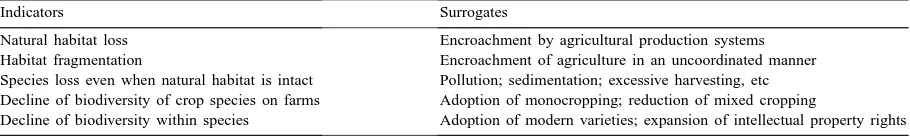
Table 1
Proposed indicators for agro-biodiversity
Indicators Surrogates
Natural habitat loss Encroachment by agricultural production systems Habitat fragmentation Encroachment of agriculture in an uncoordinated manner Species loss even when natural habitat is intact Pollution; sedimentation; excessive harvesting, etc Decline of biodiversity of crop species on farms Adoption of monocropping; reduction of mixed cropping
Decline of biodiversity within species Adoption of modern varieties; expansion of intellectual property rights
Although, data with which to assess agro-biodiversity are universally scarce, various surrogates for this can be developed using information on land use dynamics. Smith (1996) proposes some preliminary indicators and surrogates (Table 1).
Some indicators are specific to managing natural habitats, while others will be similar to those identified under land use intensity, land use diversity, and land cover (see previous section).
3.3. Core LQIs recommended for development by liaison with other authoritative groups
This activity is mostly a matter of liaison with international and national agencies already working on indicators, and selecting those indicators which best meet the requirements of the LQI program. An associated major activity will be to identify reliable sources of data, and making these available through the internet.
The LQIs included in this category are:
3.3.1. Water quality
Primary interest is on water supply and quality related to land use change, e.g. estuarine, in-land waters, irrigation water quality, etc.; link with water quality indicators already being developed under the OECD indicators program, and others.
3.3.2. Forest land quality
Primary interest is on land quality related to enviro-nmental management and forest production, specifically land quality changes related in forest management; link with the international forestry indi-cators process.
3.3.3. Rangeland quality
Primary interest is on rangeland quality related to change in land use intensity and diversity, and the role
of livestock in mixed production systems; link with range monitoring programs being developed under the convention to combat desertification, and various re-mote sensing programs.
3.3.4. Land contamination/pollution
Primary interest is on type, extent and impacts of land contamination by human interventions; inter-ested in heavy metals, organic contaminants, radioac-tive contamination, etc.; link with agencies collating available information.
4. Conclusions and recommendations
Global populations are increasing rapidly, along with the tendency to concentrate in certain agroen-vironments. For the first time in history, populations pressures are impacting global life support systems, but it is not the size of populations but the manage-ment systems practiced that impacts on land quality. If traditional ways are continued, land degradation will intensify with the concomitant collapse of certain land use systems.
However, human activities can also be agents for positive change. New, improved land management technologies for crop and animal production are necessary, particularly focusing on the health of the environment, but applied within the context of inno-vative and sympathetic social and economic policies. Indicators of land quality are needed to raise aware-ness of agricultural and environmental issues, and as instruments for monitoring progress towards or away from sustainable land management.
longer term research. These are important advances in providing direction and focus to the research ef-fort. For example, within a short time scientifically sound guidelines for several of the core indicators have been developed, and more will be designed in the near future. This experience clearly indicates that much knowledge and experience already exists on procedures for assessing land quality, and there is a good interest in the scientific community to contribute to the initiative. However, these experiences also in-dicate that the lack of suitable national and global data bases is emerging as the most severe restriction to future development and application of land quality indicators. This will require monitoring procedures for collecting the required data, but monitoring needs to be cost-effective. Various procedures can be used, including agricultural census, remote sensing, spe-cial surveys, and combinations thereof. Indicators are valuable instruments for improved decision making, but to be truly useful, they must be implemented within operational programs that provide direct guid-ance for policies of major importguid-ance.
The LQI program of the World Bank and its partners is increasing being accepted for its strategic importance within the global scientific community. Some excellent research activities are being initiated in many countries, but these often address fringe issues of local interest. Core funding to drive an organized global program has been difficult, and consequently, the big picture still remains untreated. An associated major concern is the lack of reliable, long-term data on which to monitor the impacts of land use change. These are serious obstructions to our capacity to muster effective remedial policies, pro-grams, and activities, and it is recommended that the global scientific community mobilize its collective efforts to resolve this problem.
References
Dumanski, J., 1994. Proceedings of the International Workshop on Sustainable Land Management for the 21st Century. Workshop Summary: Vol. 1. The Organizing Committee, Agricultural Institute of Canada, Ottawa.
Dumanski, J., Gregorich, L.J., Kirkwood, V., Cann, M.A., Culley, J.L.B., Coote, D.R., 1994. The status of land management practices on agricultural land in Canada. Tech. Bull. 1994-E, Centre for Land and Biological Resources Research, Agriculture and Agri-food Canada, Ottawa.
Dumanski, J., Pettapiece, W.W., McGregor, R.J., 1998. Relevance of scale dependent approaches for integrating biophysical and socio-economic information and development of agroecological indicators. Nutr. Cycling Agroecosyst. 50, 13–22.
El-Swaify, S.A., et al., 1999. Sustaining the global farm — strategic issues, principles, and approaches. International Soil Conservation Organization (ISCO), and Department of Agronomy and Soil Science, University of Hawaii, Honolulu, HI, USA.
English, J., Tiffen, M., Mortimer, M., 1994. Land resource management in Machakos District, Kenya, 1930–1990. World Bank Environment, Paper no. 5, World Bank, Washington, DC. Huffman, E., Eilers, R.G., Padbury, G., Wall, G., MacDonald, B., 2000. Canadian agri-environmental indicators related to land quality: soil cover, soil erosion, soil salinity, and risk of water contamination. Agric. Ecosyst. Environ. 81, 113–123. Ingram, J., Gregory, P., 1996. Effects of global change on soils.
GCTE Activity 3.3, Implementation Plan, GCTE Focus 3 Office, Wallingford, UK.
Oldeman, L.R., Hakkeling, R.T.A., Sombroek, W.G., 1990. World map of human-induced soil degradation. ISRIC, Wageningen, The Netherlands, UNEP, Nairobi.
Pieri, C., Dumanski, J., Hamblin, A., Young, A., 1995. Land quality indicators. World Bank Discussion Paper no. 315, World Bank, Washington, DC.
Smaling, E.M.A., Fresco, L.O., de Jager, A., 1996. Classifying, monitoring and improving soil nutrient stocks and flows in African agriculture. Ambio 8, 492–496.
Smith, N.J.H., 1996. Effects of land-use systems on the use and conservation of biodiversity. In: Srivastava, J.P., Smith, N.J.H., Forno, D.A. (Eds.), Biodiversity and Agricultural Intensification: Partners for Development and Conservation. Environmentally Sustainable Development Studies and Monographs, Series no. 11, World Bank, Washington, DC. Srivastava, J.P., Smith, N.J.H., Forno, D.A., 1996. Biodiversity
and Agricultural Intensification: Partners for Development and Conservation. Environmentally Sustainable Development Studies and Monographs, Series no. 11, The World Bank, Washington, DC.
Swift, M., 1997. Below-ground biodiversity. In: Report of the 6th Annual Review Meeting on Alternatives to Slash and Burn. Bogor, Indonesia, ICRAF, Nairobi, Kenya.
World Bank, 1997a. Rural Development: From Vision to Action. ESSD Studies and Monographs, Series no. 12, World Bank, Washington, DC.