A TASK-ORIENTED DISASTER INFORMATION CORRELATION METHOD
QIU Linyao a, DU Zhiqiang a, *, ZHU Qing b, c
a State Key Laboratory of Information Engineering in Surveying, Mapping and Remote Sensing, Wuhan University, 430079 Wuhan,
China – [email protected], [email protected], [email protected]
b State-province Joint Engineering Laboratory of Spatial Information Technology for High-Speed Railway Safety, Southwest
Jiaotong University, 610000, Chengdu, China - [email protected]
c Faculty of Geosciences and Environmental Engineering, Southwest Jiaotong University, 610000, Chengdu, China -
KEYWORDS: Disaster Data Management, Emergency Task, Ontology, Semantic Mapping, Spatial-temporal Correlation
ABSTRACT:
With the rapid development of sensor networks and Earth observation technology, a large quantity of disaster-related data is available, such as remotely sensed data, historic data, case data, simulated data, and disaster products. However, the efficiency of current data management and service systems has become increasingly difficult due to the task variety and heterogeneous data. For emergency task-oriented applications, the data searches primarily rely on artificial experience based on simple metadata indices, the high time consumption and low accuracy of which cannot satisfy the speed and veracity requirements for disaster products. In this paper, a task-oriented correlation method is proposed for efficient disaster data management and intelligent service with the objectives of 1) putting forward disaster task ontology and data ontology to unify the different semantics of multi-source information, 2) identifying the semantic mapping from emergency tasks to multiple data sources on the basis of uniform description in 1), and 3) linking task-related data automatically and calculating the correlation between each data set and a certain task. The method goes beyond traditional static management of disaster data and establishes a basis for intelligent retrieval and active dissemination of disaster information. The case study presented in this paper illustrates the use of the method on an example flood emergency relief task.
* Corresponding author: DU Zhiqiang. E-mail: [email protected].
1. INTRODUCTION
The incidence and magnitude of natural disasters worldwide have increased significantly due to climate change in recent years (Ding et al., 2014; Iwata et al., 2014; Neumayer et al., 2014). A number of natural disasters (e.g., South Asia Tsunami, the China Earthquake, the Haiti Earthquake and the Tohoku Earthquake) struck across the globe, killing hundreds and causing billions of dollars in property and infrastructure damage (Grolinger et al., 2013).
Faced with the urgent disaster mitigation situations, how to enhance the capacity of effective monitoring, early warning and emergency response has become a major challenge all around the world. On one hand, the amount of information and types of data related to disaster enhances responses greatly. As a result, disaster data, including remote sensing images, historical data, records of previous incidents, simulation data, basic geographic data and disaster assessment products, are converted from small, individual datasets at the appropriate speed, variety and veracity features, reinforcing the requirement for data integration, processing and analysis (Grolinger et al., 2013). Conversely, government agencies at different levels and individual organizations master extremely variable data resources and fulfill different disaster relief functions. To achieve good cooperation and collaboration in disaster management scenarios, the most effective data should be sent promptly to those most needing it (van Borkulo et al., 2006). In recent years, various types of sensors widely deployed in disaster monitoring networks make it possible to continuously access large disaster datasets with high spatial-temporal resolution and increasingly
rich attribute information, which provides important support for enhancing capabilities of disaster emergency responses. However, fast and easy acquisition and generation of heterogeneous data has far overloaded the existing data management ability. The main reasons are as follows: 1) most existing disaster management systems operate in a typical passive data-centric mode (Ding et al., 2014). The functions and purposes of disaster information services are focused and clear, which could rapidly satisfy specific user needs, but these systems not only will not fit the needs of the actual disaster management tasks of other user communities but also not generate products with high accuracy and veracity when the required data source is limited or not accessible. 2) Current efforts to integrate geographic information data have been restricted to keyword-based matching Spatial Information Infrastructure (SII) (Li et al., 2007). SII supports the discovery and retrieval of distributed geospatial data sources and geographic information services by providing catalogue services and syntactic interoperability standards (Lutz, 2007), but spatial-temporal characteristics of data (e.g., the spatial distribution clouds in a multispectral remote sensing image) are hidden inside the data file. Moreover, the lack of an effective mechanism for semantic association among multi-source heterogeneous data results in difficulty in passive results, such that the knowledge and discipline of the disaster are inadequately retrieved automatically. 3) Recent disaster data retrieval mainly relies on passive querying of metadata with keywords. The artificial experience plays an important role in finding available data because there are few mechanisms that
automatically discover related data and disaster knowledge for computer reasoning (Fan and Zlatanova, 2011). In practice, trivial and time-consuming operations used to integrate various resources have cost more than the manual resources, rather than improving decision making (Laniak et al., 2013). This finding is why most existing disaster management systems have been of limited use (Leskens et al., 2014) and resources cannot be fully utilized (Demir and Krajewski, 2013; Zhishan et al., 2012). This paper proposes a task-oriented disaster information correlation method, in which disaster emergency tasks are regarded as a key semantic factor to constrain, associate and compile spatial-temporal data.
Here, we discuss the challenge of managing disaster data to support various processing tasks in the even of an emergency response. The paper is organized as follows. The “Related work” section presents related work on applying semantic-related technology and ontology for spatial data and emergency response. The section titled “Task and data ontologies for disaster management” firstly analyzes types and features of emergency tasks in disaster management and puts forward an ontology model describing them. Then it describes the semantic features of disaster data in regards to attribute, space-time and statistics. “Semantic mapping of task and data” describes a map between characteristics of emergency tasks and disaster data in scale, attribute and spatial-temporal level and proposes task-oriented multi-dimensional data characteristics to analyze task preference to different data sets. The “Implementation” section introduces a case study illustrating how to aggregate data in a multilevel way to find the right data for a specific emergency task in a storm-flood disaster chain. Finally, we conclude the article in the “Conclusions and future work” section.
2. RELATED WORK
2.1 Related work on semantic technology in disaster data management
As discussed, the disaster-related data are extremely heterogeneous and different vocabularies could be used in different sources. Semantic-related technologies are employed because they can be used to identify and associate semantically corresponding concepts in disaster-related information so that the heterogeneous data can be integrated and ingested (Hristidis et al., 2010). Previous work discussed the importance of semantic-related technology for solving problems in geographical information systems (Cohn, 1997; Guarino, 1998). Cohn (1997) proposed that the human-computer interaction in GIS should be more concise and accurate than it is currently. Currently, aiming at resolving semantic diversity-generated adverse effects on data management and achieving semantic interoperation among heterogeneous data and spatial semantic description have been used in disaster data management (Fan and Zlatanova, 2011; Li et al., 2007; Zhu et al., 2009; Schulz et al., 2012; Silva et al., 2013). Schulz et al. (2012) and Silva et al. (2013) established descriptions of data by Linked Open Data (LOD). Based on semantic web knowledge, these researchers adopted RDF to define standard and exchangeable data formats for semantic annotation of disaster knowledge. LOD is considered to be an effective tool that could convert data relations to information that computers could understand, promoting automatic finding and reasoning of disaster knowledge (Foster and Grossman, 2003; Lausch et al., 2014). Michalowski (2004) also applied the Semantic Web technology to develop a Semantic Web-enabled management system. Such a system allows efficient querying of distributed information
and effectively converts legacy data into more semantic representations (Michalowski et al., 2004). Zhu (2009) analyzed challenges of intricate semantics in remote sensing information systems and proposed a hierarchical semantic restraint model as a uniform semantics description model, establishing the connection between user semantics and data and processing services as the basis of semantic reasoning in discovery, selection and composition of data and service.
2.2 Related work on ontology in disaster data management
Compared with semantic methods discussed previously, ontology has stronger semantic integrity and supports uniform descriptions from data definition to operation, which is useful for automatic finding and mining of data (G et al., 2009; Klien et al., 2006). Guarino (1998) analyzed the importance of the ontology concept in GIS systems. However, he only proposed a possible ontology structure without an attempt to implement it. Some research has provided conceptual structures of ontology in disaster management (Chatterjee and Matsuno, 2005; Li et al., 2009; Xu et al., 2009). Chatterjee and Matsuno (2005) discussed the necessity of using ontology to solve the linguistic differences. Li (2009) proposed an ontology-based architecture for geo-objects in disaster systems. Xu (2009) also suggested building an ontology-based emergency response plan. Some researchers studied specific ontology methods for semantic description (Huang and Yan, 2013; Wang et al., 2007; Yang et al., 2013). Huang (2013) proposed disaster domain ontology, including hazard-bearing body, disaster-inducing factors, inducing environment, disaster events and built connections among them using ontology. The model was experienced in disaster processing estimation and prediction. G (2009) defined ontology of disaster damage, resource, and the relationships between them such that available data resources could be found quickly while facing a certain estimating task. Wang (2007) proposed a spatial geographic ontology by analyzing objects, relationships and data in space. Such a description effectively presents hierarchical structures and semantic relations of spatial information. Yang (2013) developed a task ontology, dividing task processes into aspects of function, organization, spatial-temporal scale and complexity of calculation.
Although current semantic methods resolve problems of integration in disaster data management, most manage limited types of data and the semantic restrain or correlation of heterogeneous data is simple. Thus, a mature ontology-based data correlation method is required that can both integrate heterogeneous data from different sources and support automatic querying and reasoning functions.
3. TASK AND DATA ONTOLOGIES FOR DISASTER
MANAGEMENT
3.1 A task ontology for emergency workflow
The need for up-to-date geospatial data in emergency situations is widely recognized at present. Emergency responders may not be familiar with data standards or the appropriateness of certain datasets for a particular task. However, due to the critical nature of emergency response, responders rarely have time to sift through extensive query results and will not re-think what data sources and specific data characteristics are needed each time they face a task. Thus, it is worthwhile to formally delineate tasks and their relationships to types of data sources (Wiegand and García, 2007).
Charter Mechanism Geo-processing
Figure 1. Structure of a task ontology in an emergency response workflow
An ontology is a description, in a formal, machine-readable format, that expresses concepts including the types of entities, attributes, relationships, and values found in a domain. Ontology can represent the semantics of emergency tasks and disaster data, thus helping create connections between them for emergency response processes. Therefore, it represents knowledge of workflow processing and task demand. In this and non-functional properties, R represents the relationships between a task entity and others in an emergency workflow, S represents the semantic restraints of a task demand, P represents the priority of task execution and data retrieval in the emergency workflow, and I represents the instances of tasks.
Taking a flood response workflow from the National Disaster Reduction Center in China (NDRCC) as an example, Figure 1 shows the ontological entities and relations of disaster tasks. A set of connections composes a directed graph that specifies how the task works. The emergency workflow contains a group of tasks, such as charter mechanism based acquisition of satellite images, geo-processing of data, information extraction, collaborative judgment, remote sensing assessment and integrated assessment. Each task is an instance of an ontology entity. The relations, including sequence, parallel, interaction and fork, rule the logic order of task execution process. As the process is developing, the priority of a task changes dynamically in real time, which further influences the queue of data retrieval and preparation. For instance, when the task of collaborative judgment following geo-processing proceeds, its execution priority is higher than its successors (such as remote sensing assessment) but same as the information extraction task because they are parallel. The
semantic restraints describing the features of the task demands are composed of three parts: data information, required attributes and satisfaction. Data information confines basic features of input data, including resolution, timeliness, types of sensors and spatial system. Required attributes describe preference and selection rules for data in the background of a certain disaster. Satisfaction represents the quality of task output influenced by data quality, environmental factors, response speed and overlap extent of data with target area. The task ontology representing the function, attributes, process and need of tasks is a precondition to link task and data. It is
presented as an RDF/OWL file
(http://www.semanticweb.org/dell/ontologyies/tasks/task.owl). Snippets of the file are listed in Table 1. Hereafter, ontologies are presented in protégé for clarity.
Table 1. Snippets of the task ontology file in Turtle
<!--http://www.semanticweb.org/dell/ontologies/task#Atomic--> <owl:Class rdf:about="&task;Atomic">
<rdfs:subClassOf rdf:resource="&task;TaskType"/> </owl:Class>
<!-- http://www.semanticweb.org/dell/ontologies/task#AtomicTask -->
<owl:Class rdf:about="&task;AtomicTask"> <rdfs:subClassOf rdf:resource="&task;Task"/> </owl:Class>
<!--
http://www.semanticweb.org/dell/ontologies/task#CompositTask -->
<owl:Class rdf:about="&task;CompositTask"> <rdfs:subClassOf rdf:resource="&task;Task"/> </owl:Class>
<! http://www.semanticweb.org/dell/ontologies/task#Composite -->
<owl:Class rdf:about="&task;Composite">
<rdfs:subClassOf rdf:resource="&task;TaskType"/> </owl:Class>
Data
3.2 An ontology of disaster data
A success of disaster data management could be interpreted as “getting the right resources to the right place at the right time; to provide the right information to the right people to make the right decisions at the right level at the right time (Xu and Zlatanova, 2007).” However, semantic heterogeneity of the spatial data remains one of the biggest challenges in disaster data management. Especially as acquisition of multi-source data including remote sensing images, historic data, case data, simulation data, basic geographic data and disaster assessment products has become increasingly easy and fast, metadata catalogs based data management can neither unify heterogeneous semantics nor explicitly represent correlation of various data. Thus, a data ontology is designed to solve the Category describes the conceptual classification, such as observed data and history data, while format denotes the specific type pattern, such as GeoTiff, Img and Shpfile (as shown in Figure 2). F represents the apparent and potential features of data from three aspects: attribute, space-time and statistics. Attribute contains the inherent nature of data, which is obtained from data including spatial and temporal resolution, spatial reference and spectra. Space-time describes the spatial-temporal information, including speed of data acquisition and the area covered by data. Such information is commonly obtained from records or calculation. Statistics gives the rules and knowledge about data usage, such as the operating frequency of the data, while faced with a specific task and I represents the instances of data.
The relationships between different data instances can be described in two aspects. For data with disparate types, their correlation is described by statistical features in a common application environment, such as the co-occurrence of heterogeneous data adopted in similar historical cases. For data with the same type, the correlation is built by calculating the
but their specific values rely on the task need. For example,
w
tin temporal series analysis is higher than that in other tasks. α the data ontology could not only unify the semantic description of heterogeneous data but also offer the correlation method to automatically find other related data resources.
4. SEMANTIC MAPPING OF TASK AND DATA
Due to a lack of semantic association between tasks and data in traditional disaster data management, implicit knowledge of which data source is the most appropriate for a specific task could not be commonly applied. However, a unified description containing task and data is difficult and unnecessary because they belong to different domains and have their own respective composition, so expression with common semantic terms would neither highlight each feature characteristics nor help the system increase automatic understanding and analysis of disaster information. Clearly, one should be able to connect tasks with
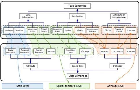
Task Semantics
Data
Information Satisfaction
Resolution Timeliness Coordinate System Type of Sensor Response Speed Overlap Quality Environmental Influence
Attribute Space-time Statistics
Spatial Resolution
Temporal Resolution
Spatial
Reference Spectrum Co-occurrence Frequency
Acquisition
Time Coverage
Data Semantics
Scale Level Spatial-temporal Level Attribute Level
Attribute of Requirement
Feature of
Disaster Preference
Accuracy Priority
Figure 3. Semantic mapping between task and data
As shown in Figure 3, the mapping relation contains almost all the task needs and features of the disaster data, and there are several mapping types including one, one-to-many and one-to-many-to-one-to-many between them. A further classification including attribute, space-time and scale is built on the basis of mapping relations. The attribute level describes a number of indicators showing which data set is more suitable for a specific task by analyzing the statistics of data usage in similar historical cases. For instance, the high co-occurrence and adoption frequency represents the importance of a data source to a task. Thus, mapping relations at the attribute level could describe what type of data source is the most suitable to a current emergency process and help the system analyze the features of correct data for automatic retrieval. The spatial-temporal level contains the direct correlation of tasks and data, such as task requirements of coordinate system, spatial reference and areal data coverage, could filter out the inappropriate data sources and choose the potential sources when the attribute-based retrieval does not find default suitable targets. The scale level mainly offers some flexible relevance factors, such as resolution of data. Such factors support analyzing the task and potential data set correlation by calculating the degree of satisfaction and finally, a list of data based on quantitative estimation of correlation could be provided for task operators.
To date, the task-oriented disaster data correlation method proposed in this paper contains three parts. First, the relationship between tasks mentioned in section 3 builds the correlation of different tasks in a workflow; therefore, the system can query and compose a workflow with required tasks by itself, which sets a goal and order for automatic data preparation. Secondly, the similarity of data with the same type is calculated in spatial and temporal aspects. So while a data set satisfying the running task is found, some other related data could be continuously searched for by the system, accompanied
with a quantitative analysis on the relevance between potentially useful data and the target. Such an operation helps a user find more suitable resources for a specific task in advance. Thirdly, a classified mapping from task semantics to data semantics is created for connecting emergency task and disaster data. The mapping then drives a multi-level-based search and filtering process to actively offer users the most suitable data satisfying the target task quickly and precisely.
5. IMPLEMENTATION
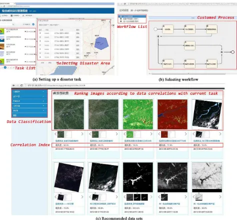
A prototype system for building custom task flow and searching suitable data is developed and integrated in an SOA-based business operation monitoring and management platform deployed at the NDRCC, which is used for monitoring and managing business concerning disaster mitigation during the whole emergency response period. Once users establish a new disaster task (as shown in Figure 4 (a)), by comparing factors such as type, level and location of disaster, with historical cases, the prototype system could set up a series of executable workflows and support man-machine manner (drag, drop and compose) to modify the process chain (as shown in Figure 4 (b)). Here, the real-time emergency response task of the flood that occurred in Fushun, China in 2013 is used as an example. There are more than 40 typical flood events from the year of 2000 stored in the historical database of the NDRCC. Therefore, through selection of atomic tasks frequently used in similar historical tasks, the system first composes a new workflow. Users can change it on the interface shown, if necessary. Then, the priority of each task is distributed based on its location in the process chain. After that, data preparation, including retrieval and selection, begins according to the priority rank.
Figure 4. The graphic interface of the prototype system
First, the system loads and parses an RDF file of the current task ontology using Jena and a list of related data types is created. Taking integrated assessment processes for instance, the type list of required data includes raster (post-disaster urban image of Fushun, flood figure), vector (administrative map, flooding extraction figure, diagram of distribution of damaged infrastructures and houses) and text (yearbook of population statistics and economy statistics in Fushun, reported data from disaster area). Next, the system starts to traverse the list to find the most suitable data for each type. Secondly, according to the correlation of task and data at the attribute level, the data with most frequent usage in historical cases will be searched. For example, the post-disaster raster image is used as a background to show the disaster area as richly as possible; images of the ZY-3 satellite were often chosen in this application, then the information will be obtained from RDF file directly. However, if the ZY-3 images could not be found in the database, further analysis to find potential data are proceeding. The system parses factors at the spatial-temporal level to build a query condition, and then images that cannot satisfy the spatial reference, area and other conditions for the Fushun flood will be filtered, and an available image set will be selected. Further, using formula
(3), the system calculates the similarity of integrated assessment and each image in the data set in space, time and resolution and ranks them according to the correlation degree. Finally, a series of images labeled with relevance to the task will be arranged in the data selection interface (shown as Figure 4 (c)) so users can choose the most suitable data for assessment.
6. CONCLUSIONS AND FUTURE WORK
Compared to existing disaster data managing methods, there are several advantages to creating a task-oriented information correlation method using ontologies. Currently, searching for geospatial data can be overwhelming when one does not know exactly which keywords to use. It can also be time-consuming to sift through undesirable results, due to either poor keyword selection or bounding coordinate discrepancies within metadata. The method described in this study offers an innovative correlation method and lowers the complexity of man-machine interaction to find data.
In this study, ontologies for tasks and data sources are created independently, and a semantic mapping between their features is established. The effort to create such a knowledge ISPRS Annals of the Photogrammetry, Remote Sensing and Spatial Information Sciences, Volume II-4/W2, 2015
base is worthwhile because the independent ontologies and their association support performing semantic-related operations on spatial data and help users to extract task-related information precisely. The analysis of data searches is expanded through introduction of an emergency task scenario. The presented work is at an early stage and further research will focus on refining the statistical factors to take full advantage of historical cases and offering formulas to quantify the similarity between statistical factors and tasks.
ACKNOWLEDGEMENTS
This work was supported by the National Natural Science Foundation of China (No. 41171311) and The National High Resolution Earth Observation System (the Civil Part) Technology Projects of China.
REFERENCES
Chatterjee, R. and Matsuno, F., 2005. Robot description ontology and disaster scene description ontology: analysis of necessity and scope in rescue infrastructure context. Advanced Robotics, 19(8): 839-859.
Cohn, A.G., 1997. Qualitative spatial representation and reasoning techniques, KI-97: Advances in Artificial Intelligence. Springer, Berlin Heidelberg, pp. 1-30.
Demir, I. and Krajewski, W.F., 2013. Towards an integrated Flood Information System: Centralized data access, analysis, and visualization. Environmental Modelling & Software, 50: 77-84.
Ding, Y. et al., 2014. An integrated geospatial information service system for disaster management in China. International Journal of Digital Earth(ahead-of-print), pp. 1-28.
Fan, Z. and Zlatanova, S., 2011. Exploring ontologies for semantic interoperability of data in emergency response. Applied Geomatics, 3(2): 109-122.
Foster, I. and Grossman, R.L., 2003. Data integration in a bandwidth-rich world. Communications of the ACM, 46(11): 50-57.
Babitski, G., Probst, F., Hoffmann, J. and Oberle, D., 2009. Ontology Design for Information Integration in Disaster Management. GI Jahrestagung, 154: 3120-3134.
Grolinger K, Capretz M, Mezghani E, et al. Knowledge as a service framework for disaster data management. Enabling Technologies: Infrastructure for Collaborative Enterprises (WETICE), 2013 IEEE 22nd International Workshop on. IEEE, 2013: 313-318.
Guarino, N., 1998. Formal ontology in information systems: Proceedings of the first international conference (FOIS'98), 46. IOS press, Trento, Italy.
Hristidis, V., Chen, S., Li, T., Luis, S. and Deng, Y., 2010. Survey of data management and analysis in disaster situations. Journal of Systems and Software, 83(10): 1701-1714.
Huang, F. and Yan, L., 2013. Reasoning of ontology model for typhoon disasters domain based on Jena. Journal of Computer Applications, 3(33): 771-775, 779.
Iwata, K., Ito, Y. and Managi, S., 2014. Public and private mitigation for natural disasters in Japan. International journal of disaster risk reduction, 7: 39-50.
Klien, E., Lutz, M. and Kuhn, W., 2006. Ontology-based discovery of geographic information services—An application in disaster management. Computers, Environment and Urban Systems, 30(1): 102-123.
Laniak, G.F. et al., 2013. Integrated environmental modeling: A vision and roadmap for the future. Environmental Modelling & Software, 39: 3-23.
Lausch, A., Schmidt, A. and Tischendorf, L., 2015. Data mining and linked open data – New perspectives for data analysis in environmental research. Ecological Modelling, 295: 5-17.
Leskens, J.G., Brugnach, M., Hoekstra, A.Y. and Schuurmans, W., 2014. Why are decisions in flood disaster management so poorly supported by information from flood models? Environmental Modelling & Software, 53: 53-61.
Li, J., Zlatanova, S. and Fabbri, A.G., 2007. Geomatics solutions for disaster management. Berlin, Heidelberg, New York, Springer.
Li, B., Liu, J., Shi, L. and Wang, Z., 2009. A method of constructing geo-object ontology in disaster system for prevention and decrease, International Symposium on Spatial Analysis, Spatial-Temporal Data Modeling, and Data Mining. International Society for Optics and Photonics. 74923I-74923I.
Lutz, M., 2007. Ontology-based descriptions for semantic discovery and composition of geoprocessing services. Geoinformatica, 11(1): 1-36.
Michalowski, M. et al., 2004. Retrieving and semantically integrating heterogeneous data from the web. Intelligent Systems, IEEE, 19(3): 72-79.
Neumayer, E., Plümper, T. and Barthel, F., 2014. The political economy of natural disaster damage. Global Environmental Change, 24: 8-19.
Schulz, A., Döweling, S. and Probst, F., 2012. Integrating Process Modeling and Linked Open Data to Improve Decision Making in Disaster Management. Guest Editors, pp. 16.
Silva, T., Wuwongse, V. and Sharma, H.N., 2013. Disaster mitigation and preparedness using linked open data. Journal of Ambient Intelligence and Humanized Computing, 4(5): 591-602.
Borkulo, V.E., Barboza, V.S., Dilo, A., Zlatanova, S. and Scholten, H., 2006. Services for emergency response systems in the Netherlands, Proceedings of the Second Symposium on Gi4DM, Goa, India, pp. 6.
Wang, Y., Gong, J. and Dai, J., 2007. Spatial Data Semantic Query Based on Ontology. Journal of Geomatics, 2(32): 32-34.
Wiegand, N. and García, C., 2007. A Task‐Based Ontology Approach to Automate Geospatial Data Retrieval. Transactions in GIS, 11(3): 355 - 376.
Xu, R., Dai, X., Yang, F. and Lin, P., 2009. Research on the construction method of emergency plan ontology based-on owl,
The 2009 International Symposium on Web Information Systems and Applications, Nanchang, China, pp. 019-023.
Xu, W. and Zlatanova, S., 2007. Ontologies for disaster management response. Geomatics Solutions for Disaster Management. Springer, Berlin Heidelberg, pp. 185-200.
Yang, H., Lv, G. and Sheng, Y., 2013. Distributed Collaborative Geographic Modeling Task Decomposition Method Based on HTN Planning. Acta Geodaetica et Catrtographica Sinica, 42(3): 440-446.
Zhishan, Y., Run E, L., Yanjiang, W. and Xiaoling, S., 2012. The Research on Landslide Disaster Information Publishing System Based on WebGIS. Energy Procedia, 16: 1199-1205.
Zhu, Q., Li, H. and Yang, X., 2009. Hierarchical Semantic Constraint Model for Focused Remote Sensing Information Services. GEOMATICS AND INFORMATION SCIENCE OF WUHAN UNIVERSITY, 34(12): 1454-1457.