Open Geospatial Consortium
Publication Date: 2016-01-18 Approval Date: 2015-07-13 Posted Date: 2015-06-23
Reference number of this document: OGC 15-046r2
Reference URL for this document: http://www.opengis.net/doc/PER/testbed11_ucr_flood_er
Category: Public Engineering Report
Editor(s): Eugene G. Yu, Liping Di, Ranjay Shrestha
OGC
®Testbed-11 High Resolution Flood Information
Scenario Engineering Report
Copyright © 2016 Open Geospatial Consortium.
To obtain additional rights of use, visit http://www.opengeospatial.org/legal/.
Warning
This document is not an OGC Standard. This document is an OGC Public Engineering Report created as a deliverable in an OGC Interoperability Initiative and is not an official position of the OGC membership. It is distributed for review and comment. It is subject to change without notice and may not be referred to as an OGC Standard. Further, any OGC Engineering Report should not be referenced as required or mandatory technology in procurements.
Document type: OGC® Engineering Report Document subtype: NA
License Agreement
Permission is hereby granted by the Open Geospatial Consortium, ("Licensor"), free of charge and subject to the terms set forth below, to any person obtaining a copy of this Intellectual Property and any associated documentation, to deal in the Intellectual Property without restriction (except as set forth below), including without limitation the rights to implement, use, copy, modify, merge, publish, distribute, and/or sublicense copies of the Intellectual Property, and to permit persons to whom the Intellectual Property is furnished to do so, provided that all copyright notices on the intellectual property are retained intact and that each person to whom the Intellectual Property is furnished agrees to the terms of this Agreement.
If you modify the Intellectual Property, all copies of the modified Intellectual Property must include, in addition to the above copyright notice, a notice that the Intellectual Property includes modifications that have not been approved or adopted by LICENSOR. THIS LICENSE IS A COPYRIGHT LICENSE ONLY, AND DOES NOT CONVEY ANY RIGHTS UNDER ANY PATENTS THAT MAY BE IN FORCE ANYWHERE IN THE WORLD.
THE INTELLECTUAL PROPERTY IS PROVIDED "AS IS", WITHOUT WARRANTY OF ANY KIND, EXPRESS OR IMPLIED, INCLUDING BUT NOT LIMITED TO THE WARRANTIES OF MERCHANTABILITY, FITNESS FOR A PARTICULAR PURPOSE, AND NONINFRINGEMENT OF THIRD PARTY RIGHTS. THE COPYRIGHT HOLDER OR HOLDERS INCLUDED IN THIS NOTICE DO NOT WARRANT THAT THE FUNCTIONS CONTAINED IN THE INTELLECTUAL PROPERTY WILL MEET YOUR REQUIREMENTS OR THAT THE OPERATION OF THE INTELLECTUAL PROPERTY WILL BE
UNINTERRUPTED OR ERROR FREE. ANY USE OF THE INTELLECTUAL PROPERTY SHALL BE MADE ENTIRELY AT THE USER’S OWN RISK. IN NO EVENT SHALL THE COPYRIGHT HOLDER OR ANY CONTRIBUTOR OF
INTELLECTUAL PROPERTY RIGHTS TO THE INTELLECTUAL PROPERTY BE LIABLE FOR ANY CLAIM, OR ANY DIRECT, SPECIAL, INDIRECT OR CONSEQUENTIAL DAMAGES, OR ANY DAMAGES WHATSOEVER RESULTING FROM ANY ALLEGED INFRINGEMENT OR ANY LOSS OF USE, DATA OR PROFITS, WHETHER IN AN ACTION OF CONTRACT, NEGLIGENCE OR UNDER ANY OTHER LEGAL THEORY, ARISING OUT OF OR IN CONNECTION WITH THE IMPLEMENTATION, USE, COMMERCIALIZATION OR PERFORMANCE OF THIS INTELLECTUAL PROPERTY. This license is effective until terminated. You may terminate it at any time by destroying the Intellectual Property together with all copies in any form. The license will also terminate if you fail to comply with any term or condition of this Agreement. Except as provided in the following sentence, no such termination of this license shall require the termination of any third party end-user sublicense to the Intellectual Property which is in force as of the date of notice of such termination. In addition, should the Intellectual Property, or the operation of the Intellectual Property, infringe, or in LICENSOR’s sole opinion be likely to infringe, any patent, copyright, trademark or other right of a third party, you agree that LICENSOR, in its sole discretion, may terminate this license without any compensation or liability to you, your licensees or any other party. You agree upon termination of any kind to destroy or cause to be destroyed the Intellectual Property together with all copies in any form, whether held by you or by any third party. Except as contained in this notice, the name of LICENSOR or of any other holder of a copyright in all or part of the Intellectual Property shall not be used in advertising or otherwise to promote the sale, use or other dealings in this Intellectual Property without prior written authorization of LICENSOR or such copyright holder. LICENSOR is and shall at all times be the sole entity that may authorize you or any third party to use certification marks, trademarks or other special designations to indicate compliance with any LICENSOR standards or specifications.
This Agreement is governed by the laws of the Commonwealth of Massachusetts. The application to this Agreement of the United Nations Convention on Contracts for the International Sale of Goods is hereby expressly excluded. In the event any provision of this Agreement shall be deemed unenforceable, void or invalid, such provision shall be modified so as to make it valid and enforceable, and as so modified the entire Agreement shall remain in full force and effect. No decision, action or inaction by LICENSOR shall be construed to be a waiver of any rights or remedies available to it.
Contents
Page1 Introduction ... 1
1.1 Scope ... 1
1.2 Document contributor contact points ... 1
1.3 Future work ... 2
1.4 Forward ... 2
2 References ... 2
3 Terms and definitions ... 3
4 Conventions ... 4
4.1 Abbreviated terms ... 4
4.2 UML notation ... 4
5 High resolution flood information scenario overview ... 4
6 High resolution flood information scenario ... 6
6.1 Study areas ... 6
6.1.1 San Francisco Bay ... 6
6.1.1.1 Description ... 6
6.1.1.2 Data ... 7
6.1.1.3 Flood modeling processes ... 8
6.1.2 Mozambique ... 9
6.1.2.1 Description ... 9
6.1.2.2 Data ... 10
6.1.2.3 Flood modeling processes ... 11
6.2 Data access components ... 12
6.2.1 Raster data access ... 12
6.2.2 Geographic feature access ... 13
6.3 Mapping services ... 13
6.3.1 Web Map Services ... 13
6.3.2 Web Map Tile Services ... 14
6.4 Data processing components ... 14
6.4.1 Geosyncrhonization service ... 14
6.4.2 Flood simulation model ... 14
6.4.3 On-demand flood information processing ... 15
6.5 High resolution flood information system ... 16
6.5.1 Use case 1: Dynamic parameterization of simulation models ... 17
6.5.2 Use case 2: Image transactions using WFS-T ... 18
6.5.3 Use case 3: Schema mapping ... 19
6.5.4 Use case 4: GeoPackage and geodata synchronization ... 19
6.5.5 Use case 5: Evacuation route production with GeoPackages ... 19
6.5.7 Use case 7: Preparing and planning for the future ... 20
7 Conclusions and remarks ... 21
7.1 Lessons learned ... 21
7.1.1 On-the-fly access and control models with WCPS ... 21
7.1.2 Syncrhonization of geofeatures ... 21
7.1.3 Offline geodata support with geopackage ... 22
7.1.4 High resolution imagey annotation and streaming ... 22
7.1.5 Multiple model integration for future planning ... 23
7.1.6 Domain knowledge and use of model output ... 24
7.2 Change requests ... 24
Annex A Sample request and responses from geospatial Web services ... 26
Annex B Revision History ... 49
Bibliography ... 51
Figures
Page Figure 1 — Overall architecture on the overarch flood scenario ... 5Figure 2 — Overall architecture on the high resolution flood information scenario ... 6
Figure 3. San Francisco Bay study area ... 7
Figure 4. Flooding models in San Francisco study area ... 9
Figure 5. Mozambique study area ... 10
Figure 6. Flooding models in Mozambique study area ... 11
Figure 7. Sample output of the WCPS Request ... 16
Figure 8. Sequence chart for dynamic parameterization of simulation model ... 18
Figure 9. Secquence chart for future planning ... 20
Abstract
This OGC Engineering Report describes the high-resolution flood information scenario carried out under the Urban Climate Resilience Thread of the Testbed 11 Initiative. The scenario was developed for two areas of interest: the San Francisco Bay Area and in Mozambique. The scenarios for these two locations demonstrate the interoperation and capabilities of open geospatial standards in supporting data and processing services. The prototype High Resolution Flood Information System addresses access and control of simulation models and high-resolution data in an open, worldwide, collaborative Web environment. The scenarios were designed to help testbed participants examine the feasibility and capability of using existing OGC geospatial Web Service standards in supporting the on-demand, dynamic serving of flood information from models with forecasting capacity. Change requests to OGC standards have also been identified through the Testbed activity.
Keywords
Testbed-11 High Resolution Flood Information Scenario
Engineering Report
1 Introduction
1.1 Scope
The scope of this report is to capture, describe, analyze, summarize, and recommend activities, outcomes, and change requests based on the high-resolution flood information scenario activity in the Urban Climate Resilience Thread 11.
1.2 Document contributor contact points
All questions regarding this document should be directed to the editor or the contributors:
Name Organization
Benjamin Pross 52North Chris Clark Compusult Dean Hintz Safe Software Dimitar Misev Jacobs University Eugene Yu George Mason University Gobe Hobona Envitia
Guy Schumann Remote Sensing Solutions Ingo Simmonis OGC
Li Lin George Mason University Lingjun Kang George Mason University Liping Di George Mason University Lucio Colaiacomo European Union Satellite Centre Panagiotis (Peter) A
Vretanos
CubeWerx
Peter Baumann Jacobs University Raj Singh IBM Cloudant
Ranjay Shrestha George Mason University Robin Hourtmeyers LUCiAD
1.3 Future work
Improvements to this document are desirable to further work on the following aspects. - Semantic mapping for automatic geosynchronization.
- Synchronization of geospatial processes.
1.4 Forward
Attention is drawn to the possibility that some of the elements of this document may be the subject of patent rights. The Open Geospatial Consortium shall not be held
responsible for identifying any or all such patent rights.
Recipients of this document are requested to submit, with their comments, notification of any relevant patent claims or other intellectual property rights of which they may be aware that might be infringed by any implementation of the standard set forth in this document, and to provide supporting documentation.
2 References
The following documents are referenced in this document. For dated references, subsequent amendments to, or revisions of, any of these publications do not apply. For undated references, the latest edition of the normative document referred to applies. OGC 01-068r3, Web Map Service
OGC 02-058, Web Feature Service
OGC 03-065r6, OpenGIS Web Coverage Service (WCS) Implementation Specification, version 1.0
OGC 04-094, OpenGIS Web Feature Service (WFS) Implementation Specification
OGC 05-076, OpenGIS Web Coverage Service (WCS) Implementation Specification, version 1.0.0
OGC 05-007r7, Web Processing Service
OGC 06-121r3, OGC® Web Services Common Standard
OGC 06-042, OpenGIS Web Map Service (WMS) Implementation Specification
OGC 07-067r2, OpenGIS Web Coverage Service (WCS) Implementation Specification, version 1.1.1
OGC 07-067r5, OpenGIS Web Coverage Service (WCS) Implementation Specification, version 1.1.2
OGC 07-068r4, OGC® WCS - Transaction operation extension, version 1.1.4
OGC 07-057r7, OpenGIS Web Map Tile Service Implementation Standard
OGC 08-068r2, OpenGIS Web Coverage Processing Service (WCPS) Language Interface Standard
OGC 09-110r4, OGC® WCS 2.0 Interface Standard - Core, version 2.0.1
OGC 09-025r2, OGC Web Feature Service 2.0 Interface Standard - With Corrigendum
OGC 09-025r1, OpenGIS Web Feature Service 2.0 Interface Standard (also ISO 19142)
OGC 14-065, OGC® WPS 2.0 Interface Standard
3 Terms and definitions
For the purposes of this report, the definitions specified in Clause 4 of the OWS Common Implementation Standard [OGC 06-121r3] and in OGC® Abstract Specification Topic on disasters shall apply. In addition, the following terms and definitions apply.
3.1 Flood
flood
A flood is an overflow of water that submerges land which is usually dry. The flooding event causes interruption of telecommunication and infrastructure damage when and where geospatial technologies are called for in emergency response.
3.2 Synchronization
synchronization
4 Conventions
4.1 Abbreviated terms
API Application Program Interface COM Component Object Model
CORBA Common Object Request Broker Architecture COTS Commercial Off The Shelf
DCE Distributed Computing Environment DCOM Distributed Component Object Model DCP Distributed Computing Platform IDL Interface Definition Language JPIP JPEG 2000 Interactive Protocol SRTM Shuttle Radar Topography Mission
OSM OpenStreetMap
WCS OGC Web Coverage Service WFS OGC Web Feature Service
WMS OGC Web Map Service
WPS OGC Web Processing Service
4.2 UML notation
Most diagrams that appear in this standard are presented using the Unified Modeling Language (UML) static structure diagram, as described in Subclause 5.2 of [OGC 06-121r3].
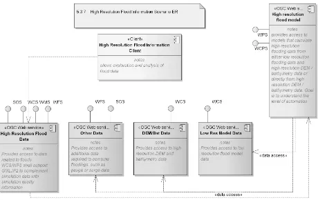
5 High resolution flood information scenario overview
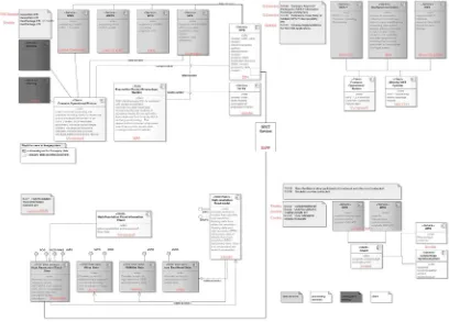
Figure 1 — Overall architecture on the flood scenario
Figure 2 — Overall architecture on the high resolution flood information scenario
6 High resolution flood information scenario
6.1 Study areas
6.1.1 San Francisco Bay
6.1.1.1 Description
Figure 3. San Francisco Bay study area
The nc file shows 31 dummy timesteps, so 31 variables essentially
("timestep_1","timestep_2","timestep_3",...). Data always show flood depth in meters. The final global 2-D flood models can be downscaled at 30 m.
6.1.1.2 Data
The data for the San Francisco study area are as follows:
USGS Computational Assessments of Scenarios of Change for the Delta
in the San Francisco Bay Region (http://cascade.wr.usgs.gov/data/Task2b-SFBay/data.shtm)
o GeoTIFF masks of areas at risk of inundation o sea level rise: 0/50/100/140/150cm
o recurrence interval or tidal datum: daily, monthly, 1/10/50/100/500 year Dynamic flood model outputs (dummy examples)
(https://portal.opengeospatial.org/files/?artifact_id=61987)
o Water depth under a sea level rise scenario of 100 cm
o "To "fake" different flood depth outputs at different times, we flooded the Lidar DEM (re-sampled at 5 m due to size of files) using incremental advances of water to different land elevation thresholds". Perhaps this can be done on the fly with a Web Coverage Processing Service (WCPS) service instance.
o Timeseries (31 time-steps in days)
Dynamic flood model outputs (real event and sea level rise, .asc/.geotiff formats)
o A 2-D high-resolution urban flood model[2][3] simulated flooding of San
Francisco Bay and San Francisco Airport (SFO) area at a 5 meter
resolution for a historic (1996) event and a sea level rise (SLR) scenario. The model was developed and provided by Remote Sensing Solutions Inc and SSBN Ltd. The model was conditioned using a high-resolution estuary model to simulate the tides and surge.
DEM.
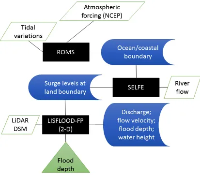
6.1.1.3 Flood modeling processes
The flood modeling processes for San Francisco Bay area consist of both land and coastal hydrological processes. Figure 4 illustrates the flood modeling processes involved in the San Francisco area. Three models, i.e. Regional Ocean Modeling System (ROMS) [4], Semi-implicit Eulerian-Lagrangian Finite Element (SELFE) [5], and LISFLOOD-FP [2][3], are used to model oceans, estuaries, and floodplains respectively. ROMS [4] is a split-explicit, free-surface, topography-following-coordinate oceanic model. It was used to model the ocean processes close to the San Francisco Bay. SELFE [5] system is
designed for simulating 3D baroclinic circulation across river-to-ocean scales. It was used to model river-to-ocean circulation in the San Francisco Bay area. LISFLOOD-FP
computationally efficient manner over complex topography. It was used to model flooding in the San Francisco Bay area. Three models worked together to model oceans, estuaries, and floodplains systematically.
Figure 4. Flooding models in San Francisco study area
6.1.2 Mozambique
6.1.2.1 Description
Figure 5. Mozambique study area
MODIS flood maps in Esri shapefile format are used to detect flooding in the area
6.1.2.2 Data
The data for the Mozambique study area are as follows:
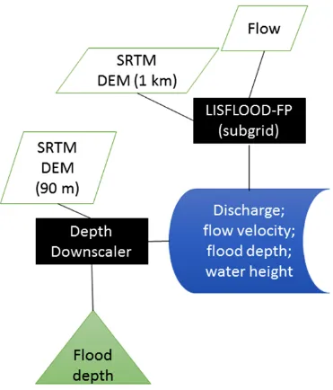
A “global-scale” version of the 2-D LISFLOOD-FP flood model[2][3][6][7] simulated a flooding at different return intervals and water depth from the model was downscaled onto the 90 meter SRTM-DEM. The model and its product were developed and provided by Remote Sensing Solutions Inc and SSBN Ltd.
Percent flooding as detected over a 14-Day composite period to render the map "cloud free" (https://portal.opengeospatial.org/files/?artifact_id=61990)
Landsat 7 jp2 compressed imagery
(https://portal.opengeospatial.org/wiki/Testbed11/UcrMozambiqueData) OSM map data
SRTM data
(https://portal.opengeospatial.org/wiki/Testbed11/UcrMozambiqueData) 6.1.2.3 Flood modeling processes
The flooding processes are mostly on land surface in Mozambique study area. LISFLOOD-FP[2][3][6][7] was used to model these flooding processes. Figure 6 illustrates the flood modeling processes involved in Mozambique study area. A
downscaling module was used to align the scales of DEM and LISTFLOOD-FP output.
6.2 Data access components
6.2.1 Raster data access
A GMU WCS was implemented to support JPIP1 output (JPEG 2000 Interactive
Protocol) along with imagery in common formats. It is compliant to OGC WCS version 1.0 (OGC 05-076, OGC 03-065r6), version 1.1.0 (OGC 06-083r8), and version 1.1.1 (OGC 07-067r2, OGC 07-068r4). Data served from the repository included Landsat and SRTM data covering both the San Francisco bay area and Mozambique. The service endpoint is at http://ows9.csiss.gmu.edu/cgi-bin/ows-wcst?
The LUCiAD WCS is an OGC-certified implementation of version 1.0.0 (OGC 05-076, OGC 03-065r6). The LUCiAD WCS serves Mozambique (imagery, DEM), New
Zealand (LINZ_Topo50 topographic map) and other demo datasets (San Francisco DEM, maritime map, bluemarble, blackmarble). The service endpoint is at
http://demo.luciad.com:8080/LuciadFusion/wcs?
The Geomatys WCS is compliant with OGC version 2.0.1 (OGC 09-110r4). It serves DEM for San Francisco Bay Area and Mozambique. The service endpoint is at:
http://ows11.geomatys.com/constellation/WS/wcs/default?
The Columbia University WCS supports OGC version 1.0 (OGC 05-076, OGC 03-065r6) 1.1.0 (OGC 06-083r8), 1.1.1 (OGC 07-067r2), and 2.0.1(OGC 09-110r4). It serves rich set of social economic data, including Amphibian Family Richness, Anthropogenic Biomes, Hazard (Frequency, Mortality Risks, (Cyclone, Economic Loss Risk, Cyclone Total Economic Loss Risk) (Cyclone, Drought, Earthquake, Flood, landslide, vocalno), population (by education, by age group), urban extents, agricultural land, ), SRTM, human influence, Nitrogen fertilizer, Percent Change in Average Annual Chlorophyll-a Concentration from 1998-2000 to 2005-2007, housing, PM 2.5, and World Database of Protected Areas. The service endpoint is at:
http://sedac.ciesin.columbia.edu:80/geoserver/wcs?
The DOE ORNL WCS supports OGC version 1.0 (OGC 05-076, OGC 03-065r6) 1.1.0 (OGC 06-083r8), and 1.1.1 (OGC 07-067r2). It serves LandScan population and forecasting data. The service endpoint is at:
http://gistpop.extranet.ornl.gov/geoserver/landscan/wcs?
The NCAR WCS supports OGC Version 1.0.0 (OGC 05-076, OGC 03-065r6). It serves output from the NCAR Community Climate System Model (CCSM). These are data output on annual, monthly and seasonal anomalies for the near term (2020-2039), mid-term (2040-2059), end of the century (2080-2099), and the last decade (2090-2099). The list of WCS service can be found through exploring their THREEDS Data Server (TDS) at:
http://tds.gisclimatechange.ucar.edu/thredds/catalog/catalog.html.
Sample WCS endpoints can be founds at:
http://tds.gisclimatechange.ucar.edu/thredds/wcs/products/files/tas_SRESB1_near_month ly_down_anomaly.nc?
6.2.2 Geographic feature access
The IBM Cloudant WFS is a RESTful JSON WFS (Web Feature Service). This service implements the emerging RESTful profile of the Web Feature Service standard. This interface is under development and not yet published outside of the WFS Working Group of the Open Geospatial Consortium. The service endpoint is at:
http://ogcwfs.mybluemix.net/. Appendix A has some sample requests and responses in GeoJSON.
The LUCiAD WFS is OGC-compliant implementation of version 1.0.0 (OGC 02-058), 1.1.0 (OGC 04-094), and 2.0.2 (OGC 09-025r2). It serves Mozambique (OSM edges, OSM nodes), New Zealand (wwAccess/wwOutFall/wwPipe/wwVents manhole data) and other demo datasets (US counties, US rivers, US cities). The service endpoint is at:
http://demo.luciad.com:8080/LuciadFusion/wfs?
The Columbia University WFS is an implementation of OGC WFS version 1.0.0 (OGC 02-058), 1.1.0 (OGC 04-094), and 2.0.2 (OGC 09-025r2). It servers Climate Change Vulnerability Scenarios 2005 2050 2100, Crop Climate: Maize, Rice, and Wheat, Agriculture, Air Pollution Effects on Ecosystems, Environmental Burden of Disease, Water Effects on Ecosystems, Greenhouse Gas Emissions, Human Sustenance, Natural Disaster Vulnerability, Reduction of Air Pollution, Administrative Boundaries - Level 1, Global Reservoir and Dam Database: Dams, Global Reservoir and Dam Database: Reservoirs. The service endpoint is at: http://sedac.ciesin.columbia.edu/geoserver/wfs
6.3 Mapping services
6.3.1 Web Map Services
The LUCiAD WMS is OGC-certified implementation of version 1.3.0 (OGC 07-042). It serves Mozambique (imagery, DEM), New Zealand (LINZ_Topo50 topographic map), US counties, cities, and rivers, Earth image and elevation data, and other demo datasets (San Fransisco DEM, OSM data, maritime map, bluemarble, blackmarble). The map can be rendered into images in format of gif, png, and jpeg. Service endpoints are at:
http://demo.luciad.com:8080/LuciadFusion/wms? and at:
http://demo.luciad.com:8080/AviationServices/fps?
The DOE ORNL WMS supports OGC version 1.3.0 (OGC 06-042. It serves LandScan population database and forecasting data. This is a compliant implementation of WMS plus most of the SLD extension (dynamic styling). It can also generate PDF, SVG, KML, and GeoRSS. The service endpoint is at:
6.3.2 Web Map Tile Services
The UAB-CREAF WMTS is an implementation of OGC WMTS version 1.0.0 (OGC 07-057r7). It serves San Francisco DEM (ASTER), Landsat-8 OLI_TIRS, and Chrischurch DEM (ASTER). The service endpoint is at:
http://www.ogc.uab.cat/cgi-bin/ogctestbed11/MiraMon.cgi?
The LUCiAD WMTS is an implementation of version 1.0.0 (OGC 07-057r7). It serves Mozambique imagery, maritime map, Earth image, and other demo datasets (bluemarble, blackmarble). The map can be rendered into images in jpeg. The service endpoint is at:
http://demo.luciad.com:8080/LuciadFusion/wmts?
6.4 Data processing components
6.4.1 Geosyncrhonization service
The Envitia GeoPackage supports OGC WPS 1.0.0 (OGC 05-007r7). It has two processes: GeoPackaging and GeoSynchronize. The WPS service endpoint is at
http://86.188.147.108:8080/MapLinkOGCServices/GPKG?
6.4.2 Flood simulation model
The 52North WPS supports OGC WPS 2.0.0 (OGC 14-065). There are two processes implemented: Flood Feature Enrichment (testbed11.FloodEnrichmentProcess) and Flood Impact Assessment (testbed11.FloodImpactAssessment). The Flood Feature Enrichment Process allows users to send their vector features to this service in order to enrich them with flood results from WCPS raster services or NetCDF raster datasets and wraps an FME Server instance (See next paragraph for more details about the process and the enclosed services). The Flood Impact Assessment process wraps GCAM model (http://www.globalchange.umd.edu/models/gcam/). The process takes a percentage of non-arable (i.e. flooded) land as input, as well as the desired output parameter of the model (e.g. commodity prices). Internally, the given percentage of land is set to
unavailable and the model is run. The impact on the requested parameter of the model due to the flooding can be assessed by comparing two diagrams of the parameter with and without unavailable land.
Safe Software implemented a Feature Enrichment REST Service on top of the GeoTIFF and NetCDF results coming from the high resolution flood model. The purpose of this service was to support the 52N WPS for vector feature enrichment. This service accepts GML features in the form of HTTP POST request, extracts the appropriate flood
workspace and then published it to FMEcloud as a REST data streaming service. This REST service was then wrapped by a WPS from 52N. Appendix A has some sample WPS requests and responses which shows how the GML was updated. FME provides a wide range of data translation, transformation and integration tools and supports close to 400 formats including relevant OGC standards (GML, web services) and many
proprietary formats and services.
6.4.3 On-demand flood information processing
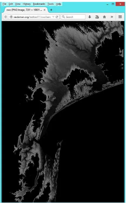
The rasdaman WCPS supports WCPS language version 1.0.0 (OGC 08-068r2). The service endpoint is at: http://rasdaman.org/testbed11/ows?
An example request to get the lowland with scaled elevation values less than 50 can be sent to the server as follows:
This URL-encoded request contains the following WCPS process.
for c in (Mozambique_DEM_2D) return encode ((c < 50) * c * 3, "PNG")
Figure 7. Sample output of the WCPS Request
6.5 High resolution flood information system
The overall interactions among the loosely coupled components are enabled and
facilitated by Standards developed by the OGC. The component interactions are captured in the subsequent use cases that demonstrate the use of the overall systems. This ER covers the overall interactions and has a focus on inundation simulation data access and model control. Details of analysis, transaction, and GeoPackage scenarios are covered in other Engineering Reports.
The interactions among the components are best viewed in the context of the flood scenario. The overall goal is to provide instant access and control to information for better event response and preparation. The scenario can be broken down into seven use cases. Each use case demonstrates different technical aspects. The use cases are:
(3) Use case 3: Schema mapping
(4) Use case 4: GeoPackage and geodata synchronization (5) Use case 5: Evacuation route production with GeoPackages (6) Use case 6: Streaming of high resolution imagery data (7) Use case 7: Preparing and planning for the future
6.5.1 Use case 1: Dynamic parameterization of simulation models
Figure 8. Sequence chart for dynamic parameterization of simulation model
Figure 8 shows the interaction sequence for dynamic parameterization of simulation models. In this use case, two flood models are implemented as Web Processing Service process. They are decoupled but they can work together seamlessly and effortlessly on the fly due to the open standards. A user could easily change the model boundary file and adds sea level rise. The changes can be submitted through a request to the server where the model would be rerun and results returned to the user. The user can interact with WCPS to make selection and to control the models.
6.5.2 Use case 2: Image transactions using WFS-T
water from entering the waste water system through vented manholes. Previously, Web Feature Services supported the transactional handling of images insufficiently. Testbed-11 enabled WFS to deal with images in a transactional way. More technical details of the use case will be covered in a separate engineering report on transactions.
6.5.3 Use case 3: Schema mapping
Data about physical items may be stored in more than one database. In the flood scenario, manhole data are stored in two enterprise systems at the city level. Both databases
contain the same data to a large extent, but differ in some feature characteristics. Dynamic schema mapping techniques are called for to facilitate the integration of data from two different systems. More technical details will be covered in a specific
engineering report on geographic feature transaction services involving WFS-T.
6.5.4 Use case 4: GeoPackage and geodata synchronization
In the emergency of flooding, internet connectivity may be an issue. It is important that even complex data can be used in offline mode. When connection is back, the
synchronization of geospatial database is necessary for purpose of updating from/to server. In the example of manhole inspection, field workers may download the data as a GeoPackage before going out into the field. Once in the field they work on those local copies. If two field workers meet in the field, data can be synchronized between the two by setting up a direct device-to-device connection. Once back home, field workers can synchronize their local copies with the enterprise system. The GeoPackage
synchronization is achieved through using WFS and WPS. More technical details will be reported in the Engineering Report on GeoPackage synchronization (15-062r2).
6.5.5 Use case 5: Evacuation route production with GeoPackages
Routing alternatives are necessary when flooding prevent access to the main evacuation routes. This becomes even more problematic when there is an issue with internet
connections and hence offline solution is needed. The underlying technology to deal with this issue is to use GeoPackages to store evacuation route alternatives for offline use. The generation and updating of GeoPackages is facilitated through WPS interfaces. More technical details will be covered in the Engineering Report on GeoPackage supporting routes (15-067).
6.5.6 Use case 6: Streaming of high resolution imagery data
Geo-referenced annotated high resolution imagery is needed at different detail levels in an emergency. Annotation may need to be done in the field with mobile devices such as smart phones. To support the efficient delivery and representation of the geo-referenced imagery, the Testbed used GMLJP2 to annotate imagery in JPEG2000 while JPIP streaming was used. The imagery was uploaded from the device to the WCS server (via WCS-T) and to a WFS server, and thus made available to users and services for
check for risks in the area with the download of annotated imagery. More technical details and change request will be reported in an Engineering Report on GMLJP2 Testing Results.
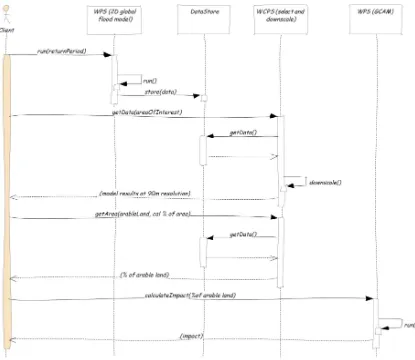
6.5.7 Use case 7: Preparing and planning for the future
Forecasting models may be implemented with different data models. Integration of results from different models can be challenging. For the flooding scenario, questions may rise for long-term planning, e.g. 20 year planning. What would happen in 20 years if global warming continues? What effect does this have to coastal populations? To answer these questions, we would combine results from flood simulation/forecasting model and GCAM. The OGC suite of standards, specifically WCPS and WPS along with geospatial encoding standards, are used to achieve the on-the-fly, customized, interoperable
accessing, processing, integrating, and presenting geospatial data.
Figure 9 shows a possible workflow to produce, integrate, and present information from different models, detailed as follows.
1) Client requests national-scale flooding calculation for 1:10, 1:100, or 1:1000 years return period
2) WPS starts model and produces 1km resolution data
3) Client provides from WCPS the percentage of arable land for Mozambique (area of interest)
4) WCPS starts downscaling and calculates classification of raster to ‘0’ outside AoI and depth to ‘1’ inside area and requests calculation of total area flooded as a percentage in the entire country area
5) WCPS returns single figure with percentage of arable land
6) Client requests impact assessment by running GCAM model behind WPS; client provides %of arable land and desired parameter for impact assessment.
7) WPS returns impact assessment as diagrams (images). The result of a model run with no flooded areas will be returned alongside the requested result for comparison. Diagrams can be visualized in the client.
7 Conclusions and remarks
7.1 Lessons learned
7.1.1 On-the-fly access and control models with WCPS
The flood emergency response needs to evaluate different alternative decisions and their outcome. This requires full understanding of consequences under specific conditions. Flood simulation models have to be experimented with different initial parameters. In this testbed, the flood modeling WPS can be set and run with user’s inputs on parameters. A user can now parameterize complex simulation models efficiently.
7.1.2 Syncrhonization of geofeatures
The geospatial databases for decision support and disaster relief need to be updated and maintained to reflect the current situation after flooding events. The update requirements can be done by either assigned field workers or volunteers. Several needs have been identified in this testbed:
(2) Geospatial databases need to stay in synchronization automatically to provide decision makers updated information for better decision in flooding emergency situation. Different schema may be involved. The schema mapping needs to be done while the updating can be properly done.
(3) Internet connections or wireless connections may be an issue during flooding disasters due to infrastructure damage. Inspections and update need to be better supported with proper data management. Information needs to stay synchronized as fast as the available internet/wireless connection allows if updating is required. The solutions to these issues are respectively proposed and tested as follows.
(1) Change request to the transaction service of WFS to support management of imagery features as attributes to geographic feature.
(2) Semantic matching and mapping of different schemas needs to be developed and adopted to support fast and robust updating of geospatial databases.
(3) GeoPackage is used to efficiently manage complex geospatial databases that allow information to be better managed when offline. Synchronization of GeoPackages is developed and tested. The method for synchronization at the GeoPackage level is found to be an efficient mechanism to support complex information maintenance.
7.1.3 Offline geodata support with geopackage
The intermittent availability of internet/wireless telecommunication can happen during flooding disasters. Maintaining continuous access to information is required while geospatial functions, such as alternative routing and geolocation, should not be interrupted. These geospatial functions require large and complex data support. This Testbed found that the OGC GeoPackage is a solution to efficiently manage complex geospatial information and databases offline while geospatial capabilities are not
suffered. GeoPackage facilitates the management of complex geospatial data to meet the informational and functional needs arisen in offline situation.
7.1.4 High resolution imagey annotation and streaming
7.1.5 Multiple model integration for future planning
One forecasting model may not be sufficient to provide enough information for future planning. Different and complex models may be invoked and triggered as quickly as information become available. Multiple runs may be required to test different
assumptions. Outputs from different models and different runs of models may be different. The testbed proposed and tested a solution to efficiently run multiple models and integrate results with the combination of WPS, WCPS, and semantic
synchronization. The solution works to some content while the problem still needs further research to support complex modeling.
It has been evident that flood scenario modeling is crucial to natural hazard planning since flooding poses one of the leading risks to life and property from any natural hazard [8]. Add to this the impact of climate change and the problem of flooding is only
exacerbated [9]. For this reason it is becoming increasingly important to not only model flooding at a local scale, but to also integrate local flood models with global climate change and impact models. This way, combined affects can be evaluated as storm events occur on top of progressive sea level rise, thereby increasing the risks and impacts over time.
Nevertheless this integration poses significant challenges. One problem that becomes immediately apparent is the question of scale. Models like GCAM are by definition global in nature, at resolutions of half a degree or lower, and time steps in the order of months or years [10][11]. Local flood models can generate output at meter or sub-meter resolution with output time steps in the order of hours or minutes.
The challenge is how to meaningfully integrate across these widely differing frames of reference. To address this, approaches called downscaling and upscaling are often used. Downscaling refers to applying global model results to local scales, in order to estimate what impact the global model results have in the local context [12]. This can be done using statistical downscaling, or dynamic downscaling [13]. An example might be the effect of increased max precipitation on a specific river valley, or the effect of sea level rise in San Francisco Bay as in this test bed case. Then there is upscaling, where local model results are scaled up or aggregated to a global scale. This can be useful when local model results are extrapolated to drive a global model. An example of upscaling might help answer what would be the global effect of a land use policy change over a large area (increased residential set back / buffers around rivers and coastlines).
Since the discussion of integration between local and global models began relatively late in Testbed 11, there was insufficient time and resources to adequately address these issues. Given the importance of multi-model integration, it is suggested that future test beds consider options for how best to address this. A variety of approaches for
be aggregated with related models on both local and global scales so that cumulative impacts can be evaluated and the aggregate impacts of policy choices can be more fully explored than before. Ultimately, better OGC support for multiple model integration would open the door to building loosely coupled systems of models to evaluate the many complexities of climate change impacts that could go well beyond the abilities of what any one model was designed to address.
7.1.6 Domain knowledge and use of model output
It is recognized that domain knowledge is required to effectively convey and utilize information. This is in alignment with the issues and discussions raised within the OGC Emergency and Disaster Management Domain Working Group (EDM DWG). Lack of domain knowledge might cause misuse of data. Large multidimensional data sets usually require specific domain knowledge beyond simple metadata. The metadata may describe model output, issues and biases using domain knowledge. View services (e.g. WMS, WMTS) should have layers generated/overseen by suitable experts to ensure that they best represent the issues under study. Additionally, view services are best used by “impacts experts” to ensure correct interpretation of risks and impacts and hence ensure appropriate decision making. Many of these discussing points and best practice
suggestions summarized within the EDM DWG have important value in guiding the practices to avoid issues of misusing data due to lack of domain knowledge. Future scenario development should more explicitly consider different user requirements. Related resources and references can be found through several registries. These needs to be further identified and studied in future testbed. Related activities and organizations should be consulted for collaboration and sharing of resources. Flood forecasting organizations (e.g. UK Flood Forecasting Centre) may be consulted for domain knowledge and data to refine the demonstration scenario. International flooding
frameworks and legislation may be consulted for guidance. For example, the INSPIRE Natural Risk Zones Data Specification
(http://inspire.ec.europa.eu/documents/Data_Specifications/INSPIRE_DataSpecification_ NZ_v3.0.pdf), EU Floods Directive (http://ec.europa.eu/environment/water/flood_risk/
and http://www.eea.europa.eu/themes/water/interactive/floods-directive-viewer) may be useful in guiding the flood scenario development.
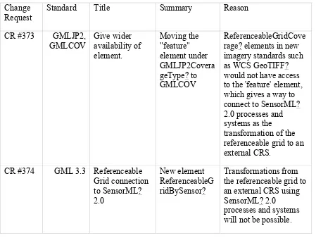
7.2 Change requests
Table 1. Change requests to OGC standards
Change Request
Standard Title Summary Reason
CR #373 GMLJP2, GMLCOV
Give wider availability of element.
Moving the "feature" element under GMLJP2Covera geType? to GMLCOV
ReferenceableGridCove rage? elements in new imagery standards such as WCS GeoTIFF? would not have access to the 'feature' element, which gives a way to connect to SensorML? 2.0 processes and systems as the transformation of the referenceable grid to an external CRS.
CR #374 GML 3.3 Referenceable Grid connection to SensorML? 2.0
New element ReferenceableG ridBySensor?
Transformations from the referenceable grid to an external CRS using SensorML? 2.0
Annex A
Sample request and responses from geospatial Web services
1. Capabilities request to IBM Cloudant RESTful JSON WFS
Request capabilities: http://ogcwfs.mybluemix.net/wfs/2.5
Response {
"WFS_Capabilities": {
"version": "2.5.0",
"xmlns": "http://www.opengis.net/wfs/2.5", "xmlns:wfs": "http://www.opengis.net/wfs/2.5", "xmlns:ows": "http://www.opengis.net/ows/1.1", "xmlns:ogc": "http://www.opengis.net/ogc", "xmlns:fes": "http://www.opengis.net/fes/2.5", "xmlns:gml": "http://www.opengis.net/gml", "xmlns:xlink": "http://www.w3.org/1999/xlink",
"xmlns:xsi": "http://www.w3.org/2001/XMLSchema-instance",
"xsi:schemaLocation": "http://www.opengis.net/wfs/2.5 http://schemas.opengis.net/wfs/2.5/wfs.xsd", "ows:ServiceIdentification":
{
"ows:Title": "OGC Testbed 11 RESTful Web Feature Service", "ows:Abstract": "Testing.",
"ows:ServiceType": {
"codeSpace": "http://www.opengeospatial.org/", "content": "WFS"
},
"ows:ServiceTypeVersion": 2.5 },
"ows:ServiceProvider": {
"ows:ProviderName": "IBM Cloud Data Services", "ows:ProviderSite":
{
"xlink:href": "http://www.cloudant.com" },
"ows:ServiceContact": {
"ows:ContactInfo": {
"ows:Voice": "617-299-1557" },
"ows:Address": {
"ows:DeliveryPoint": "200 State Street", "ows:City": "Boston",
"ows:AdministrativeArea": "MA", "ows:PostalCode": 2109, "ows:Country": "United States",
"ows:ElectronicMailAddress": "[email protected]" },
}
"name": "ImplementsSimpleWFS", "ows:NoValues": "",
"ows:DefaultValue": true },
{
"name": "ImplementsBasicWFS", "ows:NoValues": "",
"ows:DefaultValue": true },
{
"name": "KVPEncoding", "ows:NoValues": "", "ows:DefaultValue": true },
{
"name": "XMLEncoding", "ows:NoValues": "", "ows:DefaultValue": false },
{
"name": "SOAPEncoding", "ows:NoValues": "", "ows:DefaultValue": false },
{
"name": "ImplementsInheritance", "ows:NoValues": "",
}, {
"name": "ImplementsRemoteResolve", "ows:NoValues": "",
"ows:DefaultValue": false },
{
"name": "ImplementsResultPaging", "ows:NoValues": "",
"ows:DefaultValue": false },
{
"name": "ImplementsStandardJoins", "ows:NoValues": "",
"ows:DefaultValue": false },
{
"name": "ImplementsSpatialJoins", "ows:NoValues": "",
"ows:DefaultValue": false },
{
"name": "ImplementsTemporalJoins", "ows:NoValues": "",
"ows:DefaultValue": false },
{
"name": "ImplementsFeatureVersioning", "ows:NoValues": "",
"ows:DefaultValue": false },
{
"name": "ManageStoredQueries", "ows:NoValues": "",
"ows:DefaultValue": false },
{
"name": "PagingIsTransactionSafe", "ows:NoValues": "",
"ows:DefaultValue": false },
{
"name": "CountDefault", "ows:NoValues": "", "ows:DefaultValue": 200 },
{
"ows:DefaultValue": 300 },
{
"name": "ResolveLocalScope", "ows:NoValues": "", "ows:DefaultValue": "*" },
{
"name": "QueryExpressions", "ows:AllowedValues":
"type": "application/json",
"href": "http://ogcwfs.mybluemix.net/wfs/2.5/highway" },
{
"rel": "describedby",
"type": "application/schema+xml",
"href": "http://ogcwfs.mybluemix.net/wfs/2.5/highway" },
{
"rel": "alternate",
"type": "application/gml+xml; version=3.2",
"href": "http://ogcwfs.mybluemix.net/wfs/2.5/highway" },
{
"rel": "alternate",
"type": "application/vnd.geom+json",
],
"Name": "highway", "Title": "OSM highway", "DefaultCRS": "EPSG:4326",
"ows:LowerCorner": "-122.570120, 37.332920", "ows:UpperCorner": "-121.871770, 37.959670" }
"type": "application/json",
"href": "http://ogcwfs.mybluemix.net/wfs/2.5/emergency" },
{
"rel": "describedby",
"type": "application/schema+xml",
"href": "http://ogcwfs.mybluemix.net/wfs/2.5/emergency" },
{
"rel": "alternate",
"type": "application/gml+xml; version=3.2",
"href": "http://ogcwfs.mybluemix.net/wfs/2.5/emergency" },
{
"rel": "alternate",
"type": "application/vnd.geom+json",
"href": "http://ogcwfs.mybluemix.net/wfs/2.5/emergency" }
],
"application/vnd.geom+json"
"fes:ResourceIdentifier": {
"fes:SpatialOperators": {
"fes:SpatialOperator": {
2. GetFeatureById request to IBM Cloudant RESTful JSON WFS
Response {
"_id": "000064845",
"_rev": "1-aa1171c83dc31e7d5eb3423784a1eb45", "type": "Feature",
"properties": {
"gml_id": "id2ce5f3f9-4904-48ba-b19a-5e6ee57ef605", "id": 39189052,
"timestamp": "2012-12-16T00:14:30Z", "user": "Ratpick",
"uid": 60612, "version": 4,
"changeset": 14287767, "k":
469421483,
], [
-122.3021871, 37.5022205 ],
[
-122.3020154, 37.5024112 ],
[
-122.3019468, 37.5026086 ],
[
-122.3019124, 37.5027244 ],
[
-122.3020297, 37.5027905 ]
], "bbox": [
-122.3047449, 37.4987409, -122.2945093, 37.5027905 ]
} }
3. 52N Feature Enrichment Service Example
Example request and response are provided for 52N Feature Enrichment Service WPS 2.0 (wrapping FME Server flood feature enrichment REST service).
Service URL: http://ows.dev.52north.org:8080/wps/WebProcessingService Process description:
Request <?xml version="1.0" encoding="UTF-8"?>
<wps:Execute xmlns:wps="http://www.opengis.net/wps/2.0" xmlns:ows="http://www.opengis.net/ows/2.0"
xmlns:xlink="http://www.w3.org/1999/xlink"
xmlns:xsi="http://www.w3.org/2001/XMLSchema-instance" xsi:schemaLocation="http://www.opengis.net/wps/2.0 http://schemas.opengis.net/wps/2.0/wps.xsd"
service="WPS" version="2.0.0" response="document" mode="sync"> <ows:Identifier>testbed11.FloodFeatureEnrichment</ows:Identifier> <wps:Input id="floodRiskSource">
<wps:Data mimeType="text/xml">
<gml:FeatureCollection xmlns:tb11="http://www.safe.com/gml/fme" xmlns:xsi="http://www.w3.org/2001/XMLSchema-instance" xmlns:xlink="http://www.w3.org/1999/xlink"
<tb11:floodRisk gml:id="id582e787d-e61e-4692-83a6-79641d99d151"> <gml:pointProperty>
<gml:Point gml:id="id-4f6bc043-e95e-4e54-be03-e207fa43ba0d-0" srsName="epsg:4326" srsDimension="2">
<tb11:floodRisk gml:id="id582e787d-e61e-4692-83a6-79641d99d152"> <gml:pointProperty>
<gml:Point gml:id="id-4f6bc043-e95e-4e54-be03-e207fa43ba0d-1" srsName="epsg:4326" srsDimension="2">
<wps:Output id="floodRiskResult" transmission="value" /> </wps:Execute>
Response <?xml version="1.0" encoding="UTF-8"?>
<wps:Result xmlns:wps="http://www.opengis.net/wps/2.0" xmlns:xsi="http://www.w3.org/2001/XMLSchema-instance" xsi:schemaLocation="http://www.opengis.net/wps/2.0 http://schemas.opengis.net/wps/2.0/wps.xsd">
<wps:JobID>fe67a540-2e66-43b5-a781-7aa9b755ab63</wps:JobID> <wps:Output id="floodRiskResult">
<wps:Data mimeType="text/xml">
<gml:FeatureCollection xmlns:gml="http://www.opengis.net/gml/3.2" xmlns:xlink="http://www.w3.org/1999/xlink"
gml:id="id-4f6bc043-e95e-4e54-be03-e207fa43ba0d-0" srsDimension="2" srsName="epsg:4326">
<gml:pos>32.67 -25.7</gml:pos> </gml:Point>
<tb11:floodLevelMax>0.51093119382858276</tb11:floodLevelMax> <gml:description>FloodLevel=0.51093119382858276</gml:description> </tb11:floodRisk>
</gml:featureMember> <gml:featureMember> <tb11:floodRisk
gml:id="id582e787d-e61e-4692-83a6-79641d99d152" floodLevel="0.92953783273696899">
<gml:pointProperty> <gml:Point
gml:id="id-4f6bc043-e95e-4e54-be03-e207fa43ba0d-1" srsDimension="2" srsName="epsg:4326">
<gml:pos>32.86 -23.99</gml:pos> </gml:Point>
</gml:pointProperty>
<tb11:floodLevelMax>0.92953783273696899</tb11:floodLevelMax> <gml:description>FloodLevel=0.92953783273696899</gml:description> </tb11:floodRisk>
</gml:featureMember> </gml:FeatureCollection> </wps:Data>
Annex B
Initial draft and outline
2015-05-12 0.2 Eugene Yu,
- Updated the overall architecture to cover the overarch scenario instead of the narrowly-defined flood inundation modeling case.
- Added seven use cases. 2015-05-14 0.3 Eugene Yu,
- Updated sections on service components
- Updated sections in conclusive remarks
- Added sample request and response in Appendix.
- Format adjustment - List of table adjustment 2015-05-15 0.5 Eugene Yu,
Liping Di, Ranjay Shrestha
Revision - Minor revision
- Added example to the emerging standard service, e.g. WFS 2.5 2015-06-01 0.6 Eugene Yu,
Liping Di, Ranjay Shrestha
Revision - Incorporate the inputs and editing from Dean Hintz (Safe Software) - Add detailed description for service
components from Safe Software - Add example request and response for
FeatureEnricnment Service - Updated the overall architecture to
include Safe Software service 2015-06-07 0.7 Eugene Yu,
Liping Di, Ranjay Shrestha
Revision - Updated the overall diagram using the chart sent from Dr. Ingo Simmonis.
2015-06-16 0.8 Eugene Yu, Liping Di, Ranjay Shrestha
Revision - Incorporate more inputs and editing from Dean Hintz (Safe Software): flood modeling, downscaling, and related challenges and solutions. 2015-06-22 0.9 Eugene Yu,
Liping Di, Ranjay
Shrestha modeling processes for both study areas – San Francisco Bay and Mozambique, flooding models, and flowchart.
2015-08-05 1.0 Eugene Yu, Liping Di, Ranjay Shrestha
Revision - Update diagrams with high quality drawings as a response to reviewer. - Added Section 7.1.6 to incorporate
comments from reviewer Dr. James I. Penman on the role of domain knowledge.
2015-08-06 NA Carl Reed Various Prepare document for publication 2016-01-07 NA Scott
Simmons
Bibliography
[1] Guidelines for Successful OGC Interface Standards, OGC document 00-014r1
[2] Neal, J. C., Schumann, G., Fewtrell, T., Budimir, M., Bates, P. D., & Mason, D. C. (2011). Evaluating a new LISFLOOD-FP formulation with data from the summer 2007 floods in Tewkesbury, UK. Journal of Flood Risk Management, 4(2), 88–95.
[3] G. J-P. Schumann, J. C. Neal, D. C. Mason and P. D. Bates (2011). The accuracy of sequential aerial photography and SAR data for observing urban flood
dynamics, a case study of the UK summer 2007 floods. Remote Sensing of Environment. 115, 10, 2536-2546.
[4] Regional Ocean Modeling System (ROMS), URL: http://www.myroms.org/
[5] SELFE - A Circulation Model for Oceans and Estuaries, URL: http://www.stccmop.org/knowledge_transfer/software/selfe
[6] Bates, P. D., M. S. Horritt and T. J. Fewtrell (2010). A simple inertial formulation of the shallow water equations for efficient two-dimensional flood inundation modelling. Journal of Hydrology, 387, 1-2, 33–45.
[7] LISFLOOD-FP, URL:
http://www.bristol.ac.uk/geography/research/hydrology/models/lisflood/
[8] USGS: http://water.usgs.gov/osw/flood_inundation/
[9] EPA: http://www.epa.gov/climatechange/impacts-adaptation/coasts.html
[10] GCAM: http://www.globalchange.umd.edu/models/gcam/
[11] PNNL, Mohamad Hejazi “The representation of water systems in GCAM: A perspective of the human dimension in CESM”, 2015.
http://www.cesm.ucar.edu/working_groups/Societal/Presentations/14/hejazi.pdf
[12] Downscaling, Wikipedia: https://en.wikipedia.org/wiki/Downscaling
[13] Linda O. Mearns, National Center for Atmospheric Research (NCAR), “Methods of Downscaling Future Climate Information and Applications”, Boulder, CO, 2009. URL: