Strain pattern and late Precambrian deformation history in
southern Madagascar
Jean-Emmanuel Martelat
a,b,*, Jean-Marc Lardeaux
a, Christian Nicollet
b,
Raymond Rakotondrazafy
caLaboratoire de Dynamique de la Lithosphe`re,Uni6ersite´ Claude Bernard,UMR5570,43Bd du11No6embre,
69622Villeurbanne,France
bDe´partement de Ge´ologie,Uni6ersite´ Blaise Pascal,UMR6224,5Rue Kessler,63038Clermont Ferrand,France cLaboratoire de Pe´trologie,Uni6ersite´ d’Antananari6o,BP906,Antananari6o,101,Madagascar
Received 29 December 1998; accepted 5 October 1999
Abstract
This paper examines the thermo-mechanical evolution of the lower crust, in Precambrian times, with an example from southern Madagascar. The finite strain pattern is derived from the study of satellite images complemented by field structural analysis. The finite geometry reflects the superposition of two distinct finite strain patterns, D1 and D2. The geodynamic significance of the D1 event remains unclear. However, the D2 finite strain pattern is partitioned between a network of kilometric vertical shear zones and folded domains, and is consistent in the Mozambique belt with east – west shortening in a transpressive regime.The metamorphic conditions associated with the two finite strain fields show that rather uniform, high temperatures were ubiquitous in southern Madagascar. By contrast, regional pressure differences were controlled primarily by the major shear zones (D2). Chronological constraints obtained from monazite (U – Th – Pb electron microprobe dating) indicate ages of 590 – 530 Ma for the D1 event and 530 – 500 Ma for the D2 event. The two distinct strain fields D1 and D2 are continuous in time.The late pan-African transpressional tectonic regimes, contemporaneous with granulitic facies metamorphic conditions, resulted in strong strain partitioning between shear zones and folded domains. The D2 transpression was efficient and pervasive enough to exhume pieces of the lower crust. The amount of exhumation was controlled by the D2 strain gradient (amount of pure shear with respect to simple shear). © 1999 Elsevier Science B.V. All rights reserved.
Keywords:Granulite; Pan-African; Shear zones; Strain partitioning; Transpression
www.elsevier.com/locate/precamres
1. Introduction
Knowledge of both structure and petrology of the continental crust is of fundamental impor-tance in the understanding of Earth dynamics. Together with geophysical investigations and ex-* Present address: Laboratoire Pe´trologie et Tectonique,
UFR Sciences Terre, Universite´ Claude Bernard Lyon I, 43 Bd du 11 Novembre, 69622 Villeurbanne cedex, France. Fax: +33-04-72-44-85-93.
E-mail address:[email protected] (J.-E. Martelat)
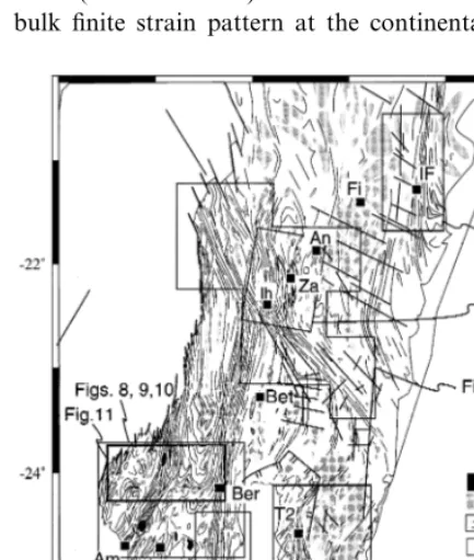
perimental studies, the study of deeply eroded Precambrian terrains offers a unique opportunity to investigate significant volumes of intermediate to low continental crust [see Harley (1992) for a general discussion]. The Precambrian belt of Madagascar represents a more-or-less continuous section in granulites and high-grade amphibolites with exceptionally diversified and preserved min-eralogies (Moine et al., 1985; Nicollet, 1988, Nicollet, 1990). Consequently, southern Madagas-car offers an excellent opportunity to establish the deformation history of a significant piece of lower
crust (\100 000 km2). We have established the
bulk finite strain pattern at the continental scale
using satellite imaging complemented by field ob-servations. In the following sections we discuss the finite strain pattern in relation to the
kinemat-ics, the P–T evolution and age distribution in
southern Madagascar. This analysis allows us to examine the role of transpression tectonics for genesis and exhumation of high-grade metamor-phic terrains.
2. Geological setting
It is well established, particularly with the pale-omagnetic constraints (Norton and Sclater, 1979; Powell et al., 1980) that Madagascar is located in the middle Gondwana and represents the eastern front of the Mozambique belt (Pallister, 1971; Shackleton, 1986; Stern, 1994). This belt is re-garded as a collision belt developed between two previously separated continental plates, namely east (India, Antarctica, Australia) and west Gond-wana (Africa and South America). However the orogenic evolution of the Mozambique Belt re-mains poorly understood. Particularly discussed are the precise duration and the timing of the pan-African tectonic events between 950 and 550 Ma (Shackleton, 1986). It is generally admit-ted that an early period of rifting (750 – 700 Ma) is followed by continental collision and tectonic es-cape in a Tibetan style during 700 – 640 Ma (Key et al., 1989; Stern, 1994). The evolution of the belt after 640 Ma, and especially the significance of the widespread granulitic metamorphism at around 550 Ma, remains unclear. This late pan-African history, well developed in southern Madagascar, is the aim of this paper.
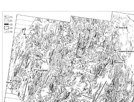
Various lithologies have been mapped in south-ern Madagascar (Fig. 1), i.e. orthogneisses,
parag-neisses, marbles, granitoids, migmatites,
metabasites and anorthosites (Besairie, 1970a,b). The regional distribution of lithologies evolves from granitoids and k-feldspar gneisses in the east to plagioclase bearing gneisses, metabasites and amphibolites, with local anorthosite massifs (Ash-wal et al., 1998), to the west. These metamorphic rocks are overlain on the west coast by rift-related late Phanerozoic through Cenozoic sediments. A Phanerozoic volcanic massif is also preserved be-Fig. 1. Geological map in southern Madagascar with major
tween the villages of Tranomaro and Beraketa.
Whereas Archean and/or early Proterozoic ages
have been depicted in northern Madagascar (Caen-Vachette, 1979; Guerrot et al., 1991; Nicollet et al., 1997; Tucker et al., 1999), in the southern part of the island a generalized pan-African syngranulitic tectonic evolution is now well established (580 – 530 Ma, Andriamarofahatra et al., 1990; Paquette et al., 1994; Kro¨ner et al., 1996; Montel et al., 1996). In all the lithologies, an extensive granulite facies
metamorphism (800950°C, Nicollet, 1990;
Wind-ley et al., 1994; Martelat et al., 1997; Martelat, 1998) is widespread, especially between 20 and 25° of southern latitude. In the following we discuss the tectonic context associated with this granulite facies metamorphism.
3. The bulk strain pattern
3.1. Methods
The deformation history and global kinematic evolution of the area were deduced from the study of the bulk finite strain pattern (Choukroune, 1987; Gapais et al., 1987). The latter was obtained through the detailed mapping of foliation and lineation trajectories in addition to observation of meso- to micro-scopic criteria of coaxial or non-coaxial strain (e.g. symmetry or asymmetry of shear bands, tails around porphyroclasts, folds). The integration of all these data, from metric to kilo-metric scales, allowed us to constrain the three-di-mensional (3D) finite strain pattern and the displacement field at the scale of the whole of southern Madagascar.
A part of the finite geometry was depicted by satellite imaging. We used 20 scenes of SPOT data from the south of Madagascar (Fig. 2) comprising three spectral bands (0.5 – 0.59mm; 0.61 – 0.68mm;
0.79 – 0.89mm) or one spectral band (0.51 –
0.73mm), with 10 m or 20 m ground resolution
respectively, taken from vertical views of 60×
60 km2 surfaces measured between June and
Sep-tember. False color compositions and black and white pictures were interpreted from isolated
im-ages or mosaics at a scale of 1/100 000 in a
Laborde-type field projection on a Hayford
ellip-soid. Common digital processing was carried out: linear stretching, filtering for edge and edge direc-tional enhancement, intensity hue saturation resti-tution and principal component analysis (Martelat, 1998). This was done especially over the key domains where complex structures interfere with one another.
In the field, the major tectonic structures are bedding-parallel foliation planes, which are recog-nizable at a metric or centimetric scale. Field strike measurements, corrected for local and regional magnetic deviation (which could reach 20°; Cattala,
1961), fit within 95°, with linear trends mapped
from SPOT images (Martelat et al., 1995; Martelat, 1998). The data indicate that the textures mapped on satellite images correspond to foliation planes on the field. Consequently, in southern Madagas-car, high-quality SPOT data and the specific geo-logic parameters of this area (relief, soil, vegetation, hydrographic framework, contrasted lithologies, high tectonic transposition), allow a textural folia-tion map to be drawn at a crustal scale (Martelat et al., 1995, 1997).
3.2. Crustal strain partitioning
Fig. 2. Mosaic of 20 SPOT satellite images acquired on the southern part of Madagascar. Numbers correspond to SPOT classification (KJ). On the two images, KJ: 166-399 and 166-398, a regular structure oriented N 10 (Ampanihy SZ) is clearly visible and contains two anorthositic bodies (a rounded one, called Saririaky, in white, is located just above the town of Ampanihy).
4. Strain pattern at different scales
In this section, we refer to four areas [(1) Ifana-diana – Fianarantsoa, (2) Ankaramena – Ihosy, (3)
Ampanihy – Beraketa, (4) Tranomaro – Fort
Dauphin], with good outcropping conditions and exposures, where geological mapping of finite
4.1. Sector 1:Ifanadiana–Fianarantsoa
4.1.1. SZ geometry
Eastwards of Fianarantsoa, a very regular zone,
Fig. 4. Interpretative map obtained from satellite images (KJ: 170-392, 170-393, Fig. 2) showing detailed foliation trajectories (oriented N 0) and major brittle faults (oriented N 120, sector 1, Ifanadiana – Fianarantsoa in text). Arrows show the limits of the major SZ (N 0, Ifanadiana SZ). Location of east – west cross-section in Fig. 5 is indicated by the gray line from Ifanadiana (If) through Ranomafana (Ran).
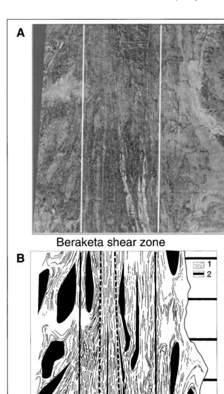
Fig. 3. Precise limits of a kilometric SZ depicted from the evolution of fold geometries (Beraketa SZ, KJ: 168 – 399, Fig. 2). (A) Satellite image; white lines correspond to the SZ limits. (B) Interpretive map obtained from (A): (1) transposed gran-ulite; (2) post-Cambrian volcanic rocks. Black thin lines: folia-tion planes, thick black lines: SZ limits, dashed thick black lines: most transposed zone. The black areas underline the spatial evolution of the closed folded structures from preserved domains (dome-and-basin domains) to the most transposed ones.
the Ifanadiana SZ, is oriented N 0 with a mini-mum length of 120 km (Figs. 2 and 4). Its width is poorly defined, as the vegetation and major brittle fault systems on the eastern coast are highly de-veloped and disturb the satellite imaging of duc-tile structures. Reasonably, the width of this structure is between 10 and 20 km. The foliation
trajectories, in agreement with the Besairie
(1970b) map, allow us to observe another SZ to the south (Fig. 13) that corresponds to an anasto-mosed southern continuation of the Ifanadiana SZ.
4.1.2. Field data
The sector in Fig. 5 exhibits a very pronounced S1 compositional layering. The transposed layers comprise various lithologies with different thick-nesses (1 mm to more than 20 m). The S1 folia-tion plane is dominantly N 0 – N 20, shallowly dipping to the west; the dominant stretching lin-eation L1 is east – west (N 250 – N 280) plunging to the west. These structural observations are com-patible with the structural data derived from an-isotropy of magnetic susceptibility from Gre´goire
and Ne´de´lec (1997). The tectonites show LBS or
gran-ites, with sharp contacts between surrounding para- or ortho-gneisses, are parallel to the S1 foliation plane. These syntectonic granites, 10 – 50 m or more thick by 50 km long, seem to be similar to the so-called ‘stratoid granites’ well known north of Antananarivo (Emberger, 1958; Ne´de´lec et al., 1994, 1995). We observe, at the metric scale, recumbent folds (F1) with domi-nantly N 270 and more rarely N 0, subhorizontal to gently west-dipping hinge lines. Conjugate
shear bands are developed in both XZ and YZ
sections of the finite strain ellipsoid. These ge-ometries indicate vertical shortening under mainly coaxial strain (D1). In some places, scarce asym-metric folds (F1) coherent with the orientations of intruding leucosomes in gneisses indicate a local non-coaxial strain with a systematic westwards normal displacement.
The S1 foliation can also be locally folded into kilometric open folds with subhorizontal axes (Fig. 5), yielding at map-scale the rounded shapes similar to the type I interference pattern observed in the dome-and-basin domains. These F2 folds with north – south axial planes are coherent with a global east – west shortening (D2). In some places, the first S1 – L1 fabric is reworked by a new penetrative S2 – L2 fabric. The new S2 foliation is vertical and L2 is subhorizontal, giving rise to the
development of S=L tectonites (Flinn, 1965).
These vertical domains reach 500 m wide by sev-eral kilometers long, but near Ifanadiana these structures are homogeneous at a kilometric scale (Figs. 4 and 5). This zone corresponds to the Ifanadiana SZ, depicted on the satellite images.
Inside this SZ, some shear bands are conjugate at angles of 35 – 40° and numerous isoclinal folds show hinge lines varying from vertical to horizon-tal attitudes. These features (strong symmetry of the tectonic fabric and of strain indicators) are coherent with a strong east – west horizontal shortening (D2) under mainly coaxial strain.
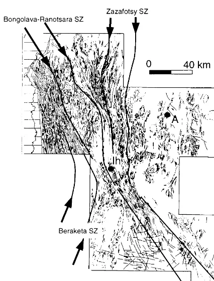
4.2. Sector 2: Ankaramena–Ihosy
4.2.1. SZ geometry
Close to Ihosy village (Fig. 6) we find two main structural directions: one N 0 and the other N 140 – 150. The first is coherent with the geome-try of the Beraketa SZ (northern termination), whereas the second is representative of the Bon-golava – Ranotsara SZ (Bazot, 1976; Nicollet, 1988). The deflection of the foliation trajectories in the vicinity of the Bongolava – Ranotsara SZ looks like a crustal scale C/S structure (Berthe´ et al., 1979) indicating a sinistral sense of shear. Such a geometry is also well evidenced by the pattern of a small-scale SZ network (3 – 5 km wide, located northward from Ihosy, Fig. 5). The N 140-oriented Bongolava – Ranotsara SZ is badly defined to the east, where the density of N 140 faults increases, and to the west, where the struc-ture interferes with smaller anastomosing SZs. Westwards, this structure disappears beneath the post-Cambrian sedimentary cover. From this limit, up to the Mozambique channel, numerous kilometric brittle faults are observed in the Creta-ceous cover (Premoli, 1977) and are in the prolon-gation and parallel with ductile foliation plane
Fig. 6. Detailed foliation trajectories from Fig. 1 (sector 2, Ankaramena – Ihosy in text). Same legend as in Fig. 3. The heavy black lines define the limits of the Bongolava – Ranot-sara SZ, Beraketa SZ, and Zazafotsy SZ. The density of brittle structures increases from north-east to south-east and disturb the interpretation of ductile structures.
4.2.2. Field data
From Ankaramena to Zazafotsy (Fig. 7), we clearly follow the transposition from D1 ge-ometries into D2 fabrics: 20 km west of Ankara-mena, the regional subhorizontal S1 fabric is gently folded into kilometer-scale F2 open folds with subhorizontal hinge lines (synforms and an-tiforms). Near the boundary of the Zazafotsy SZ the folds become upright and unrooted (Fig. 7). The S1 plane (N 0 – N 20) is transposed into a new penetrative N 170, subvertical S2 foliation plane, and the L1 east – west stretching lineation is pro-gressively replaced by the L2 subhorizontal lineation.
Between the towns of Zazafotsy and Ihosy, vertical structures dominate. The F2 folds are upright and unrooted with folded, subhorizontal hinge lines. In this transect we cross two major SZs, the Bongolava – Ranotsara underlined by an N 140 vertical foliation plane (S2) and the Za-zafotsy SZ underlined by N 170 vertical planes (S2). In these SZs the rocks are S – L tectonites (Flinn, 1965).
In the Zazafotsy SZ, despite the high strain underlined by the intense tectonic transposition, we never observe clear asymmetry of the strain markers and the development of conjugate shear bands, and isoclinal folds is compatible with bulk coaxial strain due to an east – west shortening. On the contrary, in the Bongolava – Ranotsara SZ the deflection at a kilometric scale of the foliation trajectories indicates a non-coaxial deformation coherent with a sinistral strike-slip motion. More-over, in the field, numerous shear bands or drag folds are compatible with sinistral strike-slip. However, subordinate conjugate meter-scale SZs, as well as symmetric boudinage, are also observed and are compatible with a global shortening per-pendicular to the walls of the SZ.
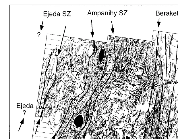
4.3. Sector 3: Ampanihy–Beraketa
4.3.1. SZ geometry
In the southern and southwestern part of Madagascar we can recognize three major SZs (Fig. 8): Ejeda, Ampanihy and Beraketa [also called Vorokafotra SZ by Rolin (1991)] that cor-respond to regular zones of 20 km width, oriented (top left, Fig. 1). Brittle faults developed in this
cover could be controlled by older tectonic struc-tures at depth, such as Bongolava – Ranotsara SZ; we guess that the Bongolava – Ranotsara SZ reaches at least 350 km in length. Near Ihosy the width of this SZ is about 20 km, in other places the width of the Bongolava – Ranotsara SZ is more difficult to trace, because the SZ boundaries interfere with kilometric-scale normal faults and other SZs to the south and to the north.
between N 0 and N 15. The length of the Beraketa SZ is at least 250 km (Fig. 1); its northern limit becomes parallel to the N 140 trending Bon-golava – Ranotsara SZ (Fig. 6). The length of the Ejeda and Ampanihy SZs are unknown because their northern and southern extents lie beneath the post-Cambrian sedimentary cover. We note a clear discontinuity between the three SZs and the adjacent dome-and-basin domains.
4.3.2. Field data
In this part of the island the vertical S2 folia-tion planes consist regionally of a transposed lithological layering. Inside the Beraketa SZ, the S2 foliation plane is commonly oriented N 0, 90°. The stretching lineation L2 is subhorizontal, and only locally plunges 5 – 30° to the north (Figs. 9 – 11). Towards the west, in the adjacent dome-and-basin domain, the foliation planes strongly
Fig. 8. Detailed foliation trajectories from Fig. 1 (sector 3, Ampanihy – Beraketa in text). Thinnest black lines are foliation planes. Arrows show the limits of the different SZs (Beraketa SZ, Ampanihy SZ, Ejeda SZ). Two large black, ovoid shapes in Ampanihy SZ are the anorthositic bodies; other symbols same as in Fig. 3.
dip. S1 planes are folded into kilometric F2 folds with vertical axial planes and subhorizontal folded hinge lines. The F2 folds may be associated with a new crenulation cleavage (vertical S2 plane), giving rise to an intersection lineation. On the map, the folds are ovoid with two dominant axial traces (N 10 and N 90, Fig. 9). Sometimes they form complex ‘mushroom’ shapes with the second fold axial trace oriented N 0 or N 90 (Fig. 9). In some places the S1 foliation trajectories underlined typical type III interference patterns (Fig. 11), with the last fold axial trace oriented N 0. The L1 stretching is globally oriented N 250, plunging towards the south or the south-west (20 – 60°). L1 stretching lineations are reoriented by the F2 folds (west from Beraketa and Tra-noroa towns, Fig. 10).
In the Ampanihy SZ, S2 planes are mainly vertical. They are rotated at the vicinity of the two anorthositic bodies (Saririaky and Ankafo-tia), which behave as rigid particles in a ductile matrix (Martelat et al., 1997). On the north-east boundary of the Ampanihy SZ the S1 foliation
planes dip towards the east (40 – 70°), whereas on the southwestern limit the planes are dipping west (40 – 70°). Some subhorizontal stretching lin-eations L2 can be observed, underlined by quartz rods. To the north-west, east and south-west of the SZ we clearly observed the transposi-tion of steeply plunging L1 lineatransposi-tion, oriented N 220 or N 80, into a subhorizontal L2 lineation with an N 5 orientation.
Westwards from Ampanihy SZ the folds are more closed with highly folded hinge lines and the L1 lineations are more steeply dipping than in the other eastern dome-and-basin domains.
At the eastern boundary of the Ejeda SZ the S2 planes are vertical and oriented N 5, and they bear a dominant L2 (N 30, 50°S) stretching lineation.
contradic-tory shear sense criteria and numerous metric upright folds with vertical to horizontal hinge lines in the Ampanihy and Ejeda SZs coherent with dominant coaxial strain and horizontal east – west shortening. In the Ampanihy SZ we proposed a sinistral displacement (Martelat et al., 1995, 1997). On the other hand, in the Be-raketa SZ, asymmetric tails around minerals, drag folds and shear bands indicate a more im-portant non-coaxial strain. These non-coaxial kinematic indicators are compatible with a dex-tral slip system (Rakotondrazafy, 1992).
The kilometric F2 folds observed in the two dome-and-basin domains delimited by the Ejeda,
Ampanihy and Beraketa SZs result from the deformation of the S1 planes and give rise
to kilometric-scale synforms and antiforms
and associated minor folds. This folding event
is compatible with a dominant east – west
horizontal shortening. F2 folds show vertical
axial planes and subhorizontal, gently
folded hinge lines. They can interfere with the previous F1 folds described in sector 1
(horizontal axial planes and N 0 or N 90
horizontal hinge lines) and lead to the develop-ment of the type II and type III interference patterns (Ramsay, 1967; Thiessen and Means, 1980).
Fig. 10. Detailed stretching lineation trajectories from sector 3. (1) Granulite and stretching lineation; other symbols same as in Fig. 9.
4.4. Sector 4:Tranomaro–Fort Dauphin
4.4.1. SZ geometry
In the southeastern part of Madagascar highly strained domains are also observed from satellite images (170-399, Fig. 2) and geological maps (de la Roche and Marchal, 1956; Noizet et al., 1958; Bazot et al., 1978). These features tend to be less regular and smaller (3 – 5 km width by 100 km long) than the previously described zones. Among
these smaller SZs we distinguish the Fort
Dauphin SZ and the Tranomaro SZ systems (near the villages of Tranomaro and Fort Dauphin, Fig. 12).
4.4.2. Field data
F2 folds are well developed. This evolution in space clearly represents a finite strain gradient giving rise to an anastomosed framework of mi-nor ductile SZs. In these SZs, asymmetric and symmetric shear criteria indicate, as in previously described SZs, a combination of: (1) pure shear associated with the regional east – west shortening and (2) simple shear associated with, in this case dextral, strike-slip shearing.
5. Deformation history
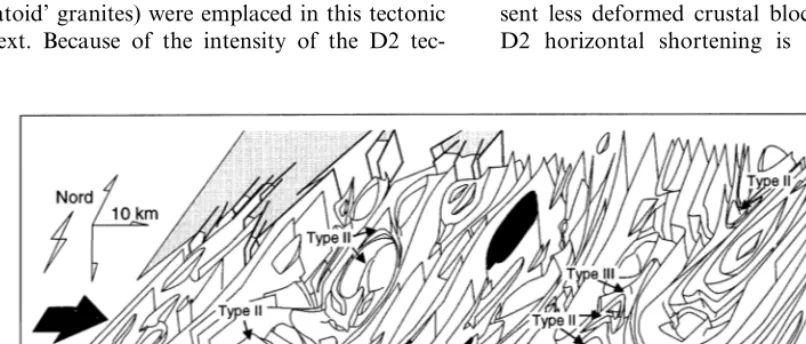
In southern Madagascar (from 20° of southern latitude) the deformation history clearly results from the superposition of two finite strain pat-terns D1 and D2 (Fig. 13). The D1 strain pattern is characterized by a subhorizontal foliation plane and an L1 mineral stretching lineation globally trending east – west (N 240 – N 270). The S1 fabric corresponds to transposed lithologies giving rise to a compositional layering. Shear criteria are
observed both inXZandYZsections of the finite
strain ellipsoid and are coherent with vertical shortening with local westwards normal displace-ments. Numerous syntectonic sheetlike granites (‘stratoid’ granites) were emplaced in this tectonic context. Because of the intensity of the D2
tec-tonic event, and of the lack of clear kinematic shear criteria, the tectonic significance of the D1 strain pattern remains unclear.
The D1 structures were reworked during the D2 event, when gradual folding of the S1 planes led to complete transposition of these planes into the high-strain SZs. In the SZs, a new penetrative S2 vertical foliation and a subhorizontal lineation developed. Two kinds of SZ were identified: a major SZ (15 – 25 km wide by more than 100 km long) and a minor SZ (3 – 5kilometers wide by less than 100 km long). With the exception of the Bongolava – Ranotsara SZ, which is elongated N 140, all the SZs are globally parallel and north – south oriented.
In the folded domains (dome-and-basin do-mains), the geometry indicates an evolution from open to upright folds. The folds are more tight in the western part of the studied area (i.e. west of Ampanihy SZ) and, south of the Bongolava – Ra-notsara SZ, the intensity of the folding process is compatible with a D2 strain gradient increasing from east to west.
The D2 finite strain pattern shows a strong strain partitioning between vertical SZs and the surrounding dome-and-basin domains that repre-sent less deformed crustal blocks. The east – west D2 horizontal shortening is accommodated by
Fig. 13. 3D finite strain pattern of southern Madagascar result showing the superposition of the two events D1 and D2. (1) Stretching lineation: black arrow=L2, gray arrow=L1, (2) SZs, other symbols same as in Fig. 1. Bottom portion of figure is a schematic east – west cross-section. The kinematics of the last D2 event are indicated by the thick black arrows.
folding in the blocks (pure shear-dominated do-main), yielding interference pattern geometries with previous F1 folds (D1 structures) and strike-slip displacement (simple shear dominated do-main) in the SZs. Moreover within the SZs, combined pure shear and simple shear accommo-dates east – west shortening. Thus, this D2 finite strain pattern reflects a transpressive tectonic regime, as defined by Robin and Cruden (1994) and Sanderson and Marchini (1984), with differ-ent ratios of simple shear versus pure shear (Thompson et al., 1997) inside the SZs as well as between the SZs (i.e. in the folded domains).
6. Metamorphism and deformation
min-eral assemblages that underlined both D1 and D2 tectonic fabrics. Typical assemblages (De Waard, 1965; Vielzeuf, 1983) include two pyroxenes – plagioclase – quartz assemblages with rare garnet in metabasites and spinel – quartz associations in
metasediments. The precise metamorphic
conditions associated with the two finite strain fields have been measured by applying standard methods (e.g. exchange thermobarometry; Spear,
1993) and multiequilibrium thermobarometry
(TWEEQ software; Berman, 1988, 1990) on mafic and silico-aluminous lithologies (Fig. 14; Nicollet, 1985, 1988, 1990; Rakotondrazafy, 1992; Martelat, 1998). Our results are compatible with other estimations (Ackermand et al., 1989, 1991; Ne´de´lec et al., 1992; Gre´goire and Ne´de´lec, 1997) and
demonstrate that uniform high-temperature
conditions (750 – 850°C) existed throughout
southern Madagascar. The calculations also reveal regional pressure differences between the different crustal blocks separated by the SZs. Maximum
pressure conditions (P=12 kbar) occur in the
southwestern part of the area studied, whereas
minimum pressures (P=5 kbar) were recorded in
the eastern block and northern block (Fig. 14). The
calculated P–T paths indicate decompression
under high-temperature conditions. The highest
pressure and decompres- sion under high
temperature were recorded westwards. Eastwards rocks recorded smaller pressure and a weak decompression observable on the field with numerous destabilization in paragneisses of garnet and sillimanite into cordierite. On the northern blocks we only observe the cooling of rocks at the end of the metamorphic phase. Since the D2 SZs juxtapose blocks recording different amounts of
decompression, we suggest that the D2
transpressive regime was responsible for the main part of the exhumation of Madagascar granulites.
7. Age of deformation
Chronologic estimates using the E-probe dating monazite method (Th – U – Pb, Montel et al., 1996) have been undertaken to obtain a better con-straint on the age of deformation of these rocks. The age determination is based on the simulta-neous measurement, directly on thin sections, of Th – U – Pb concentrations in monazite with an analytical protocol after Montel et al. (1994, 1996). On a single thin section numerous ages can be obtained. A statistical method developed by Montel et al. (1996) is used to deal with the large number of data and to characterize the popula-tion of results (unimodal, bimodal, etc.). Results obtained by both methods (E-probe dating and conventional isotopic methods) show a good de-gree of reliability. Thus E-probe dating monazite is relevant to date magmatism or metamorphism events in a huge variety of tectonic regimes (Mon-tel et al., 1994, 1996). This in situ dating method allows the different measures in the monazite and its relations with other minerals and with the Fig. 14.P–T–tdata and finite strain pattern. Foreground: the
Table 1
Ages obtained from in situ measurement, on thin sections, of Th–U–Pb concentrations in monazite (Montel et al., 1994, 1996). The first column corresponds to sample relationships with the different SZs: inside mSZ (minor SZ), inside MSZ (major SZ) or outside SZ (in dome-and-basin domains or crustal blocks). The different blocks are individualized by the SZs (B–A: block between Beraketa and Ampanihy SZs; W–A: block westwards from Ampanihy SZ; F–T: block between Fort Dauphin and Tranomaro SZ systems; north-east: block westwards from Ifanadiana SZ). The precise location of samples is indicated in Fig. 14. The ages are obtained by statistical calculations; for some samples there are two or three (sample 13) populations of results
Mineral paragenesis
Location Rock type Age (Ma) Fig. 14: no
Charnockite Qtz-Fk-Pl-Opx-Bt-Grt
Block F–T 558912; 6469 19 1
(south-east)
Block F–T Mineral of monaz- 550920 4
(south-east) ite
Qtz-Fk-Grt-Opx-Bt 590932
Block T–B (center) Leucocratic gneiss 5
Bt-Crd-Sap-Krn 567918; 1003953
Paragneiss 11
Block T–B (center)
Bt-Grt-Crd
Block B–A (west) Paragneiss 529921 6
Qtz-Spl-Fk-Pl-Bt-Grt-Crd 539920; 1389985
Paragneiss 8
Block B–A (west)
Leucocratic gneiss
Block B–A (west) Qtz-Fk-Grt-Bt 534923 12
Paragneiss Qtz-Fk-Pl-Bt-Grt-Crd-Sill 529923 7 Block W–A
(south-west)
Block north-east Leucocratic gneiss Qtz-Fk-Grt-Bt 515920; 848945 15 Charnockite
mSZ south-east Qtz-Fk-Pl-Opx-Bt-Grt 53697 2
Qtz-Fk-Pl-Opx-Bt-Grt 52398
Charnockite 3
mSZ south-east
Qtz-Spl-Fk-Bt-Grt-Crd 502932
MSZ Beraketa Paragneiss 9
Qtz-Fk-Pl-Bt-Grt-Sill-Opx-Sap-Crd 488924; 736934
Paragneiss 10
MSZ Beraketa
Paragneiss
MSZ Bongolava-R Qtz-Fk-Pl-Bt-Grt-Sill-Crd 375928; 481941; 13 17529103
Qtz-Fk-Pl-Opx 430932
MSZ Bongolava-R Charnockite 14
tectonic structures to be controlled. Finally, this method is one order of magnitude less precise than conventional isotopic methods. In the south-ern Madagascar island, the method was per-formed on various leucocratic lithologies, such as gneisses or charnockites, and one giant monazite crystal in a leucosome (15 samples, results are presented in Table 1 with locations from Fig. 14). Out of the major SZs, in the region dominated by the flat-lying structures (D1 event), the ages lies between 590 and 515 Ma. These data are consistent with the results of Paquette et al. (1994) obtained on granites and charnockites by single U – Pb on monazites and zircons or Sm – Nd iso-topic studies on minerals and whole rocks. Their results come from metagranite showing a gently dipping foliation associated with the D1 struc-tures. They depicted a synchronous peak of meta-morphism in all the south-east between 580 and 565 Ma (Paquette et al., 1994). These results are
systemat-ically identify younger ages between 500 and 375 Ma: 500 – 490 Ma in the Beraketa SZ; ages between 480 and 430 Ma and one population around 375 Ma in the Bongolava – Ranotsara SZ. Because the ages below 500 Ma are without tec-tonothermal significance in the Mozambique belt (Stern, 1994), we suggest that the syngranulitic D2
strain pattern, associated with crustal fluid (CO2
rich) flow (Pili et al., 1997a), finished between 530 Ma and 500 Ma. As discussed previously, kilometric brittle faults are controlled by previous main ductile tectonic structures (especially Bon-golava – Ranotsara SZ). Thus the youngest ages
(B500 Ma) should be coherent with a resetting
(Pb loss with late fluid circulation in the upper crust) during the development of brittle struc-tures, possibly during the opening of the Mozam-bique channel (from Jurassic to Cretaceous).
8. Discussion and conclusions
A regional study that integrates multi-scale tec-tonic analysis, metamorphic petrology and mon-azite E-probe dating has been realized in southern Madagascar. The granulitic Precambrian rocks and structures are attributable to late pan-African time (590 – 500 Ma). In the southernmost part of the area studied (south of Fianarantsoa), two major pan-African deformation events have been recognized. The first one (D1) is represented by a flat-lying granulitic foliation and stratoid granites coeval with isoclinal folds and bearing E – W-stretching lineations. The second one (D2) corre-sponds to the development of a vertical SZ network (the major ones being rooted in the mantle; Pili et al., 1997b) and to steep refolding of D1 fabrics. In these SZs, which are mainly trend-ing between N 0 and N 20 in the actual position of the island, a poorly deepening stretching lin-eation is well developed. Only the Bongolava – Ra-notsara, the latest SZ cross-cutting other major SZs, is oriented N 140. Thus, tectonic history results from the superposition of the two late pan-African syngranulitic finite strain patterns D1 and D2 continuously developed through time. The D1 finite strain pattern was developed at around 590 – 530 Ma, whereas the D2 event was
effective until 530 – 500 Ma (D1 and D2 seems to represent a whole progressive deformation event). Concerning the previous tectonic structures, the D1 event should be either compatible with thick-ening processes or with post-collisional extension. In both tectonic contexts, high-temperature low pressure metamorphism conditions and huge amounts of granite should be produced (England and Thompson, 1984; de Yoreo et al., 1989, Malavielle et al., 1990; Gardien et al., 1997). For example, in northern Madagascar extensional tec-tonics was proposed to explain the emplacement of stratoid granites (Ne´de´lec et al., 1994, 1995). Regarding the intensity of D2 reworking, in southern Madagascar a kinematic history of D1 event is questionable. As in other Precambrian fields, the geodynamic significance of such
hori-zontal tectonic structures remains unclear
(Harley, 1992).
The D2 bulk strain pattern is clearly related to a transpressional regime during bulk horizontal shortening of heated crust. This transpression, contemporaneous with granulite facies conditions, resulted in a strain partitioning between the anas-tomosing SZ network and folded domains. The dome-and-basin domains are folded under a pure shear-dominated strain regime, whereas the SZs show a component of the simple shear regime. Inside the SZs the strain also varies, from simple to pure shear, depending on their positions in space.
of lithologies from acid to more basic from east to west where deeper crustal levels outcrop.
Thus, Madagascar represents an opportunity of studying the evolution and exhumation of
deep-seated rocks during an obliquely convergent (transpressive) orogen. The cratons convergence (Tanzanian craton westwards and Dharwar cra-ton eastwards, Fig. 15) promotes the shortening of a hotter and softer piece of continental litho-sphere. We suggest that such mechanical
hetero-geneites (i.e. cratons) in the soft heated
lithosphere could control strain partitioning at the scale of the whole of Gondwana. We think that the SZs dominated by pure shear are located at the front of the cratons with respect to the east – west convergence (oriented N 0 Ampanihy or Za-zafotsy SZs). The SZs dominated by simple shear are located to the sides of the cratons (oriented N 140 SZs Bongolava – Ranotsara SZ and its pro-longation in Kenya).
Acknowledgements
The study was supported by CNRS – INSU – DBT ‘Dynamique globale’ and programme
‘Tec-toscope-positionnement’. We are grateful to
Elizabeth Eide for improving an earlier version of this manuscript and also Anne Ne´de´lec and Pierre Choukroune for constructive reviews. The UMR 5563 (Lab. d’e´tude des me´canismes de transfert en ge´ologie, Toulouse) is acknowledged for provid-ing SPOT images (KJ: 169-394, 169-393, 170-399).
References
Ackermand, D., Windley, B.F., Razafiniparany, A., 1989. The Precambrian mobile belt of southern Madagascar. In: Daly, J.S., Cliff, R.A., Yardleys, B.W.D. (Eds.), Evolution of Metamorphic Belts. In: Geol. Soc. Spec. Publ, vol. 43, pp. 293 – 296.
Ackermand, D., Windley, B.F., Razafiniparany, A., 1991. Kornerupine breakdown reactions in paragneisses from southern Madagascar. Mineral. Mag. 55, 71 – 80. Andriamarofahatra, J., De La Boisse, H., Nicollet, C., 1990.
Datation U – Pb sur monazites et zircons du dernier e´pisode tectono-me´tamorphique granulitique majeur dans le Sud-Est de Madagascar. C. R. Acad. Sci. Paris 310, 1643 – 1648.
Ashwal, L.D., Hamilton, M.A., Morel, V.P., Rambeloson, R., 1998. Geology, petrology and isotope geochemistry of massif-type anorthosites from southwest Madagascar. Contrib. Mineral. Petrol. 133, 389 – 401.
Bazot, G., 1976. Contribution a` l’e´tude des formations me´ta-morphiques pre´cambriennes du Sud-Est de Madagascar. Thesis (unpublished), Universite´ Clermont-Ferrand, 200 pp.
Bazot, G., Razafimanantsoa, A., Ramanitriraisana, C., 1978. Carte ge´ol., Sainte Luce, e´chelle 1: 100 000. Service Ge´ol. Madagascar, Antananarivo.
Berman, R.G., 1988. Internally-consistent thermodynamic data for minerals in the system Na2O – K2O – CaO – MgO –
FeO – Fe2O3– Al2O3– SiO2– TiO2– H2O – CO2. J. Petrol. 29,
445 – 522.
Berman, R.G., 1990. Mixing properties of Ca – Mg – Fe – Mn garnets. Am. Mineral. 75, 328 – 344.
Berthe´, D., Choukroune, P., Je´gouzo, P., 1979. Orthogneiss, mylonite and non coaxial deformation of granites: the example of the south Armorican shear zone. J. Struct. Geol. 1, 31 – 42.
Besairie, H., 1970a. Carte ge´ol., Fianarantsoa, e´chelle 1:500 000. Service Ge´ol. Madagascar, Antananarivo. Besairie, H., 1970b. Carte ge´ol., Ampanihy, e´chelle 1:500 000.
Service Ge´ol. Madagascar, Antananarivo.
Caen-Vachette, M., 1979. Le Pre´cambrien de Madagascar. Radiochronome´trie par isochrones Rb/Sr sur roches to-tales. Rev. Ge´ol. Dynam. Ge´og. Phys. 21, 331 – 338. Cattala, L., 1961. Carte de la de´clinaison magne´tique a`
Mada-gascar pour le 1er juillet 1958, e´chelle 1:2 500 000. Service Ge´ol. Madagascar, Antananarivo.
Choukroune, P., 1987. Shear criteria and structural symmetry. J. Struct. Geol. 9, 525 – 530.
Daly, M.C., 1986. The intracratonic Irumide Belt of Zambia and its bearing on collision orogeny during the Proterozoic of Africa. In: Coward, M.P., Ries, A.C. (Eds.), Collision Tectonics. In: Geol. Soc. London, Spec. Publ, pp. 321 – 328.
De la Roche, H., Marchal, J., 1956. Carte ge´ologique, Manan-tenina Fort-Dauphin (N.O. 60-61, N.O. 62-63), e´chelle 1:200 000. Service Ge´ol. Madagascar, Antananarivo. De Waard, D., 1965. The occurence of garnet in the
granulite-facies terrane of the Adirondack highlands. J. Petrol. 6, 165 – 191.
De Yoreo, J.J., Lux, D.R., Guidotti, C.V., 1989. The role of crustal anatexis and magma migration in regions of thick-ened continental crust. In: Daly, M.C., Cliff, R.A., Yard-leys, B.W.D. (Eds.), Evolution of Metamorphic Belts. In: Geol. Soc. Spec. Publ, vol. 43, pp. 187 – 202.
Emberger, A., 1958. Les granites stratoı¨des du pays Betsileo (Madagascar). Bull. Soc. Ge´ol. France VIII, 537 – 554. England, P.C., Thompson, A.B., 1984. Pressure – temperature –
time paths of metamorphism. I. Heat transfer during the evolution of thickened continental crust. J. Petrol. 25, 894 – 928.
Flinn, D., 1965. On the symmetry principle and the deforma-tion ellipsoid. Geol. Mag. 102, 36 – 45.
Gapais, D., Bale, P., Choukroune, P., Cobbold, P., Mahjoub, Y., Marquer, D., 1987. Bulk kinematics from shear zone patterns: some field examples. J. Struct. Geol. 9, 635 – 646.
Gardien, V., Lardeaux, J.M., Ledru, P., Allemand, P., Guillot, S., Guerrot, A., 1997. Metamorphism during late orogenic extension insights from the french Variscan Belt. Bull. Soc. Ge´ol. France 168, 271 – 286.
Gre´goire, V., Ne´de´lec, A., 1997. Pan-African Andringitrean granites of Madagascar: structure and P–Templacement conditions. In: Terra Abstr. EUG 9, Strasbourg, p. 464. Guerrot, C., Cocherie, A., Ohnenstetter, M., 1991. Les
com-plexes ultrabasiques de la zone Ouest Andriamena (Mada-gascar): contraintes ge´ochronologiques. Principaux re´sultats Scientifiques et te´chniques du B.R.G.M., 99 – 101. Harley, S.L., 1992. Proterozoic granulite terranes. In: Condie, K.C. (Ed.), Proterozoic Crustal Evolution. Elsevier, pp. 301 – 359.
Kenah, C., Hollister, L.S., 1983. Anatexis in the central gneiss complex, British Columbia. In: Atherton, M.P., Gribble, A. (Eds.), Migmatites, Melting and Metamorphism. Shiva, Nantwich, pp. 142 – 162.
Key, R.M., Charsley, T.J., Hackman, B.D., Wilkinson, A.F., Rundle, C.C., 1989. Superimposed upper proterozoic colli-sion-controlled orogenies in the mozambique orogenic belt of Kenya. Precamb. Res. 44, 197 – 225.
Klerkx, J., Lie´geois, J.P., Lavreau, J., Claessens, W., 1987. Crustal Evolution of the Northern Kibaran Belt, Eastern and Central Africa. American Geophysical Union, pp. 217 – 233.
Kro¨ner, A., Braun, I., Jaeckel, P., 1996. Zircon geochronology of anatectic melts and residues from high-grade pellitic assemblage at Ihosy, southern Madagascar: evidence for Pan-African granulite metamorphism. Geol. Mag. 133, 311 – 323.
Malavielle, J., Guihot, P., Costa, S., Lardeaux, J.M., Gardien, V., 1990. Collapse of a thickenned crust in the French Massif Central: Mont Pilat extensional shear zone and Saint-Etienne Upper Carboniferous basin. Tectonophysics 177, 139 – 149.
Martelat, J.E., 1998. Evolution thermome´canique de la crouˆte infe´rieure du Sud de Madagascar. Ph.D. Thesis (unpub-lished), Universite´ B.P. Clermont-Ferrand II, 230 pp. Martelat, J.E., Vidal, G., Lardeaux, J.M., Nicollet, C.,
Rako-tondrazafy, R., 1995. Satellite images and tectonics of the lower continental crust: The example of South-Western Madagascar. C. R. Acad. Sci. Paris 321 (se´rie IIa), 325 – 332.
Martelat, J.E., Nicollet, C., Lardeaux, J.M., Vidal, G., Rako-tondrazafy, R., 1997. Lithospheric tectonic structures de-veloped under high-grade metamorphism in the southern part of Madagascar. Geod. Acta 10 (3), 94 – 114. Moine, B., Rakotondratsima, C., Cuney, M., 1985. Les
pyrox-e´nites a` urano-thorianite du Sud-Est de Madagascar: con-ditions physico-chimiques de la me´tasomatose. Bull. Mine´ral 108, 325 – 340.
Montel, J.M., Foret, S., Veschambre, M., Nicollet, C., Provost, A., 1996. Electron microprobe dating of monazite. Chem. Geol. 131, 37 – 53.
Ne´de´lec, A., Moine, B., Rakotondrazafy, M., 1992. Granulites du Sud-Est de Madagascar: thermobarome´trie des leptynites de Fort-Dauphin. In: 14e`me Re´union Sciences Terre, Tou-louse, p. 113.
Ne´de´lec, A., Paquette, J.-L., Bouchez, J.-L., Olivier, P., Ralison, B., 1994. Stratoid granites of Madagascar: structure and position in the Panafrican orogeny. Geod. Acta 7, 48 – 56. Ne´de´lec, A., Stephens, W.E., Fallick, A.E., 1995. The panafrican stratoid granites of Madagascar: alkaline mag-matism in a post-collisional extensional setting. J. Petrol. 36, 1367 – 1391.
Nicollet, C., 1985. Les gneiss rubane´s a` cordie´rite et grenat d’Ihosy: un marqueur thermobarome´trique dans le Sud de Madagascar. Precamb. Res. 301, 175 – 185.
Nicollet, C., 1988. Me´tabasites granulitiques, anorthosites et roches associe´es de la crouˆte infe´rieure. Exemple pris a` Madagascar et dans le Massif Central Franc¸ais. Arguments en faveur d’un me´tamorphisme associe´ a` l’extension litho-sphe´rique. The`se d’Etat (unpublished), Universite´ Clermont-Ferrand, 315 pp.
Nicollet, C., 1990. Crustal evolution of the granulites of Madagascar. In: Vielzeuf, D., Vidal, P. (Eds.), Granulites and Crustal Evolution. Kluwer, pp. 291 – 310.
Nicollet, C., Montel, J.M., Foret, S., Martelat, J.E., Rakoton-drazafy, R., Lardeaux, J.M., 1997. E-probe monazite dating in Madagascar: a good example of the usefulness of the in-situ dating method. In: Ashwal, L.D., Cox, R. (Eds.), UNESCO – IUGS – IGCP 348/368. Internal Symposium and Field Workshop on Proterozoic geology of Madagascar. Abstract volume, p. 65.
Noizet, G., Delbos, L., Orloff, O., Marchal, J., Besson, M., de la Roche, H., 1958. Carte ge´ol, Tsivory – Esira (J.K 60-61, L.M 60-61), Madagascar. Service Ge´ol. Madagascar, e´chelle 1:200 000.
Norton, I.O., Sclater, J.G., 1979. A model for evolution of the Indian ocean and the breakup of Gondwanaland. J. Geophys. Res. 84 (B12), 6803 – 6830.
Pallister, J.W., 1971. The tectonics of East Africa. In: Tectonics of Africa, U.N.E.S.C.O, Paris, vol. 6, pp. 511 – 543 Paquette, J.-L., Ne´de´lec, A., 1998. A new insight into
Pan-African tectonics in the East – West Gondwana collision zone by U – Pb zircon dating of granites from central Madagascar. Earth Planet. Sci. Lett. 155, 45 – 56. Paquette, J.-L., Ne´de´lec, A., Moine, B., Rakotondrazafy, M.,
1994. U – Pb, single zircon Pb-evaporation, and Sm – Nd isotopic study of a granulite domain in SE Madagascar. J. Geol. 102, 523 – 538.
Pili, E., Sheppard, S.M.F., Lardeaux, J.M., Martelat, J.E., Nicollet, C., 1997a. Fluid flow vs. scale of shear zones in the lower continental crust and the granulite paradox. Geology 25, 15 – 18.
Pili, E., Ricard, Y., Lardeaux, J.M., Sheppard, S.M.F., 1997b. Lithospheric shear zones and mantle – crust connections. Tectonophysics 280, 15 – 29.
Powell, C.M., Johnson, B.D., Veevers, J.J., 1980. A revised fit of east and west Gondwanaland. Tectonophysics 63, 13 – 29. Premoli, C. 1977. Carte tectonique de Madagascar e´chelle
1:200 000, OMNIS, special publication. Antananarivo. Rakotondrazafy, R., 1992. Etude pe´trologique de la se´rie
granulitique Pan-Africaine de la re´gion d’Ampandandrava: Sud Madagascar. Ph.D. Thesis (unpublished), Universite´ Antananarivo, 121 pp.
Ramsay, J.G., 1967. Folding and Fracturing of Rocks. Mc-Graw-Hill, New York 567 pp.
Robin, P.Y.F., Cruden, A.R., 1994. Strain vorticity patterns in ideally ductile transpression zones. J. Struct. Geol. 16, 447 – 466.
Rolin, P., 1991. Pre´sence de de´crochements pre´cambriens dans le bouclier me´ridional de Madagascar: implications struc-turales et ge´odynamiques. C. R. Acad. Sci. Paris 312, 625 – 629.
Sanderson, D.J., Marchini, W.R.D., 1984. Transpression. J. Struct. Geol. 6, 449 – 458.
Shackleton, R.M., 1986. Precambrian collision tectonic in Africa. In: Coward, M.P., Ries, A.C. (Eds.), Collision Tectonics. In: Geol. Soc. London, Spec. Publ, pp. 329 – 349. Spear, F.S., 1993. Metamorphic Phase Equilibria and Pressure – Temperature – Time Paths. In: Mineralogical Society of America Monograph. 799 pp.
Stern, R.J., 1994. Arc assembly and continental collision in the Neoproterozoic East African Orogen: implications for the consolidation of Gondwana. Annu. Rev. Earth Planet. Sci. Lett. 22, 319 – 351.
Thiessen, R.L., Means, W.D., 1980. Classification of fold interference patterns: a reexamination. J. Struct. Geol. 2, 311 – 316.
Thompson, A.B., Schulmann, K., Jezek, J., 1997. Thermal evolution and exhumation in obliquely convergent (trans-pressive) orogens. Tectonophysics 280, 171 – 184. Tucker, R.D., Ashwal, L.D., Handke, M.J., Hamilton, M.A.,
Le Grange, M., Rambeloson, R.A., 1999. U – Pb geochronology and isotope geochemistry of the archean and proterozoic rocks of north-central Madagascar. J. Geol. 107, 135 – 153.
Vielzeuf, D., 1983. The spinel and quartz associations in high grade xenoliths from Tallante (S.E. Spain) and their poten-tial use in geothermometry and barometry. Contrib. Min-eral. Petrol. 82, 301 – 311.
Windley, B.F., Bridgwater, D., 1971. The Evolution of Ar-chaean Low- and High-grade Terrains. In: Geol. Soc. Aust. Spec. Publ, vol. 3, pp. 33 – 46.