Reference number: 167
WATERSHED MORPHOMETRY ON QUATERNARY VOLCANIC TERRAIN IN SOUTHERN MARGIN OF THE BANDUNG BASIN:
ITS IMPLICATION IN DISTRIBUTION OF FLOOD AREA
Emi Sukiyah1) , Adjat Sudradjat2), R. Febri Hirnawan2), Dicky Muslim2), Nana Sulaksana2), Ildrem Syafri2), Djadjang Sukarna3) 1)
Doctor Candidate of Geology, Postgraduate Programme, University of Padjadjaran, Bandung, Indonesia.
2)
Dept. of Geology, Faculty of Mathematic and Natural Sciences, University of Padjadjaran,Bandung, Indonesia.
3)
Geological Survey Institute, Energy and Mineral Resources Ministry, Republic of Indonesia.
Abstract
Southern part of Bandung basin was hilly and mountainous terrain that composed of Quaternary volcanic rocks. Volcanic terrain, mainly in mature stage, shows the tendency to have irregular pattern with is not easily classified into several type. Drainage basin morphometry is indices of geomorphologic aspects used to analyze the characteristics of flood area. Several criteria of drainage basin morphometry were measured in the field, i.e. river order, length of river segment, cumulative length of river segments (Lu), bifurcation ratio (Rb), ratio of Lu of different orders (Lu/Lu+1).
The quantitative approach used to calculate numerical data of drainage basin characteristics. In this region, several types of flood area occur. Every type characterized by specific curve representing relationship between morphometric variables. For geo-spatial analysis encompassing terrain mapping, flood area distribution, and numerical data calculation, the Geographic Information System (GIS) is used.
Several aspects, i.e. climate, rainfall intensity, slope, land use, stream order and rock type control distribution of flood area. Result of geo-spatial analysis shows research area divided four zones, i.e. vulnerable flood, flood potency, little flood probability and lost flood. The analyses of morphometry indices show that several parameters are inter-related. There are relation between length of river segments and stream order. On the graph, the region of vulnerable flood showed by pattern of curve lines to be far apart. The non-vulnerable area indicated by pattern of curve lines to be very close together. There are real relationships between variables of stream order and flood area distribution. This relation demonstrated by the correlation index (r) with the value of 0.676 to 0.999. The phenomena exhibit that the Quaternary volcanic terrain has a little regularity of patterns to explain flood vulnerable area.
Introduction
Base on strategic location from several aspects, many towns grow and develop at hill foot or mount, beach, around of big river, etc. (Legget, 1973). Urban locations implies at around of big river have high risk through flood. Flood happen when the existing drainage can not fit runoff, so water upload and flooding into around area (Strahler & Strahler, 1984).
Bandung region was lying in intermountain basin. In Bandung basin, Citarum river and tributaries flow. The Citarum become life source for population at Bandung Regency, Bandung City and Cimahi City (Research and Development Centre of Water Resources, 2005). The Citarum support region development in Bandung and surrounding, the other side posses many problems.
Morphometry of the upper Citarum can change every time because man activity and geological phenomena. Watershed morphometry dynamic can influence capacity for store and runoff. Furthermore, continuously morphometry study very important to know capacity of natural river at specific times.
Crickmay (1974) had definite watershed and basin. Watershed is boundary between two basins. It is the sharp intersection of two gradients that steeping towards it as far as they are stream-made. The total area of land that slopes towards the branches of a river system is the basin. Several indicators of watershed and basin characteristics among others are aspects of topography, geology, geomorphology, soil, vegetation, land use and land cover (Syehan, 1977; in Roswandi, 2004). A geomorphology aspect as indicator of watershed and river basin characteristics is morphometry. Van Zuidam (1983) had definite morphometry as
quantification a landform. Result of morphometry analyze are numerical data can determine landform characteristic. They can become database to application in hydrology, disaster management, natural resources exploration, etc.
The southern part of Bandung basin consists of hilly and mountainous terrain that composed of Quaternary volcanic rocks. Physiographically, the area is apart of Bandung depression zone and Quaternary volcanic product (Van Bemmelen, 1949).
consist sub trellis, dendritic, rectangular and sub radier. Based on characteristic of valley and drainage pattern, for example valleys with cross section to form modification from “V” to “U” letters, so erosion grade show early youth maturity (Thornburry, 1969), except at steep slopes to form “V” valley profile.
Geology and evolution of Bandung basin had been investigated by several previous investigator, i.e. Klompe (1956, in Koesoemadinata, 1979), Silitonga (1973), Alzwar et al (1992) and Dam (1994). Generally, rock composition of Cirasta watershed are Quaternary volcano activity product and a little apart as Holocene and Recent deposits. Quaternary volcano activity products are tuff, andesite-basalt lava, volcanic and laharic breccias. Several geological structures in this area are Lembang fault (at northern), Ciparay fault (at southern), Mandalawangi fault (at eastern), etc.
Methodology
Data analyze use quantitative approach to get data of watershed or river basin characteristic. On the other hand, Geographic Information System (GIS) tool is used to geo-spatial analysis for know flood zoning. Several aspects, i.e. climate, rainfall intensity, slope, land use, stream order and rock type control distribution of flood area (Sukiyah et al, 2004).
The variables of watershed morphometry including several aspects are length, area and relief. The length aspects are river length, watershed perimeter, length and width of river basin. Measurement of area aspect are watershed area, watershed morphology and river density. Relief aspect are fixing of up stream and down stream of river segment on every
order. Furthermore, the variables calculated, fixing of stream order and its averages for every order, fixing of river density value and river basin rudeness.
and data available of land capability aspects are various. Total scores of all aspects depend on number of aspects are analyzed. So, they need statistic calculation for uniform final value, i.e. use normal distribution curve.
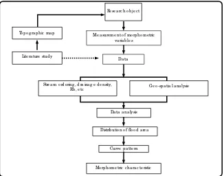
The research activity can be divide to some stages, i.e. literature study and topographic maps preparation, volcanic terrain interpretation, measurement of morphometry variables, field survey and ground check, data analyze, delineation of flood area distribution, interpretation of curve pattern, and morphometric characteristic of every zone of flood (Figure 2).
Result and Discussion
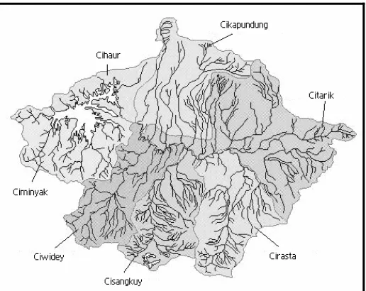
The Cirasta sub-watershed is a part of the seven sub-watersheds in upper Citarum watershed (LCLUC, 2001). Area of Cirasta sub watershed approximately 272.5 sq km, elongate form with relative north-south direction. It has maximum width to achieve 7.0695 km. Base on calculation, density river to reach 2.8507 km per sq km. River network of the sub watershed include stream order 1, 2, 3, 4, 5 and 6. The total river segments approximately 714 segments. Table 1 shows that drainage morphometry.
Base on texture rudeness, morphology of research area divided three units, i.e. volcanic terrain with rough texture, volcanic terrain with semi rough texture and river valley (Figure 4). The viewing of textures is reflection of river density and volcanic rock properties.
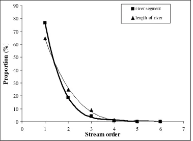
Specific curve line pattern represent relation between cummulative length of river segments and stream order (Figure 5). Stream orders 4 and 5 have anomalies. They connect
with active fault. Several river segments reflect phenomena at around of fault. Normally, total length of river segments of stream order 4 ought to more length and order 5 more short than existing data. The field evidence, influence of fault effect is stream order 4 becomes shorter and river with order 5 become more length.
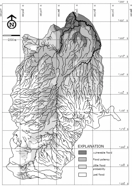
Result of geo-spatial analysis shows research area divided four zones, i.e. vulnerable flood, flood potency, little flood probability and lost flood. The flood zoning based on several aspects, i.e. climate, rainfall intensity, slope, land use, stream order and rock type. Every zone has specific characteristic morphometry.
At the upper Citarum, area of flood moved to reach 19.1 sq km and to increase eventually morphometry of upper river changed. The condition can event recollect area of potency flood more spreader, i.e. 69.68 sq km. The regions to approach mount peak or hill peak are relative more save area than the others. The area reaches 71.67 sq km and area of lost flood to reach 112.1 sq km.
The Cicangkuang watershed, Citonjong Watershed and Cikoneng watershed are part of Cirasta sub watershed. The analysis results of total river segments at every stream order of them show their characteristic no significant difference. Furthermore, we can conclude the characteristic of stream order of Cirasta sub watershed relative the same.
The total length of river segments upside down to ward reaching of stream order. The same phenomena valid to the total cummulative river segment too. The stream order increase up side down to the total cummulative river segments. The average length of river segment comparable with stream order increasing. It is mean if stream order to increase then length of river segment shall increase too.
The all of Cirasta sub watershed is a normal watershed base on Rb calculation. It is mean tectonic control no significant. The condition showed by Rb extended from 3 to 4.14 base on Rb classification by Verstappen (1983). Nevertheless, several watersheds that part of Cirasta sub watershed controlled by fault, i.e. Barugbug watershed, Cirawa watershed, Cihejo watershed, upper Cirasea at Patrol, etc.
On relation graph between cummulative of river segments (v1) and cummulative length of river segments (v2) toward stream order, the region vulnerable flood is shown by pattern of curve lines to be far apart (Figure 6). The non-vulnerable area will indicated by pattern of curve lines to be very close together (Figure 7, 8 and 9).
Significantly, morphometry of Cirasta sub watershed has changed. The phenomena indicated by distribution of region of flood potency had been reaching to upper stream (Figure 10). More over, low values of river order join to extend region of flood potency. The condition happen because sub watershed damage had to reach upper stream. One of reason is destruction of conservation forest area by human activity.
phenomena supported by analysis of curve line pattern. There are real relationships between variables of stream order and flood area distribution. This relation demonstrated by the correlation index (r) between actual result of calculation and trend line with the value of 0.676 to 0.999 (Table 3). The phenomena exhibit that the Quaternary volcanic terrain has a little regularity of patterns to explain flood vulnerable area.
Conclusion
Cirasta sub watershed is a part of the upper Citarum watershed. Cirasta sub watershed has area approximately 272.5 sq km, elongate form with relative direction north-east, maximum width to achieve 7.0695 km, density river approximately 2.8507 km /sq km. Cirasta sub watershed contains 714 river segments with stream order 1 to 6.
Base on risk grade of flood, the area can divided four zones, i.e. vulnerable flood, flood potency, little flood probability and lost flood. Every zone characterized by specific curve representing relation between morphometric variables.
The analyses of morphometry indices show that several parameters are inter-related. There are relation between length of river segments and stream order. On the graph, the region vulnerable flood showed by pattern of curve lines to be far apart. The non-vulnerable area indicated by pattern of curve lines to be very close together. There are real relationships between variables of stream order and flood area distribution. This relation demonstrated by the correlation index (r) between actual result of calculation and trend line with the value of 0.676 to 0.999. The phenomena exhibit that the Quaternary volcanic terrain has a little
regularity of patterns to explain flood vulnerable area.
The distribution of region vulnerable of flood indicated by stream order various increasing. The region vulnerable of flood in Cirasta sub watershed lies on mouth of sub-watershed. It is ending area of rivers with more low order. The regions vulnerable of flood have distribution of area are 19.1 sq km. They can reach according to morphometry dynamic of that watershed.
Acknowledgement
References
Alzwar, M., Akbar, N. and Bachri, S. 1992. Geology of Garut and Pameungpeuk sheet, Java. Geological Research and Development Centre. Bandung, Indonesia.
Crickmay, C. H. 1974. The Work of The River. The Macmillan Press Ltd. Great Britain. 271p.
Dam, M. A. C. 1994. The Late Quaternary Evolution of The Bandung Basin, West-Java, Indonesia. Thesis, Department of Quaternary Geology, Faculty of Earth Sciences. Vrije Universiteit, Amsterdam, The Netherlands. 252p.
Howard, Arthur D, and Remson, Irwin. 1978. Geology in Environmental Planning. McGraw-Hill Inc. USA. 478p.
Koesoemadinata, R.P. 1979. Geology of Bandung Plateau. Proccedings. The 10th Annual Convention of Indonesian Geologist Association. Bandung, Indonesia. *)
Legget, R.F. 1973. Cities and Geology. McGraw-Hill Inc. San Fransisco, USA. 624p.
LCLUC. 2001. Land Cover Land Use Changes, Indonesian case study. <http://www.geocities.com/luccindo/fs_citarum2.html> [28/02/2004]
Research and Development Centre of Water Resources. 2005. Rivers Catalog of Indonesia. Vol. 1. Bandung, Indonesia. 33p. *)
Roswandi, Deny. 2004. Morphometry of The Upper Cikapundung River Basin, Bandung Regency, West Java Province. Department of Geology, Faculty of Mathematic and Natural Sciences, University of Padjadjaran. 105p. *)
Strahler, Arthur N. & Alan H. Strahler, 1984, Elements of Physical Geography, John Wiley & Sons, New York. 538p.
Sukiyah, Emi, Haryanto, Agus Didit and Zakaria, Zufialdi. 2004. The Application of Geographic Information System in Analysis of Flood Area at Southern Part of Bandung Regency. Bulletin Scientific Contribution Vol. 1 No. 2: 26-37.*)
Thornbury, D. William. 1969. Principles of Geomorphology. John Willey & Sons Inc. New York – London – Sidney - Toronto. 594p.
Van Bemmelen, R.W. 1949. The Geology of Indonesia and Adjacent Archipelagoes, General Geology. Martinus Nijhoff The Hague, vol. IA: 25-28.
Van Zuidam, R. A. 1983. Guide to Geomorphologic - aerial photographic interpretation and mapping. Enschede: Section of Geology and Geomorphology, ITC. 325p.
Verstappen, H. Th. 1983. Applied Geomorphology: Geomorphological Surveys for Environmental Development. Elsevier Science Publishing Company Inc. New York. 437p.
Figure 1. Location of research area
Figure 2. Main frame and stages of research Me a sure me nt o f mo rp ho me tric
va ria b le s
Lite ra ture stud y
Da ta a na lysis
Distrib utio n o f flo o d a re a Da ta
Ge o -sp a tia l a na lysis Stre a m o rd e ring , d ra ina g e d e nsity,
Rb , e tc
Curve p a tte rn
Mo rp ho me tric c ha ra c te ristic To p o g ra p hic ma p
Figure 3. Sub watersheds of upper Citarum watershed in Bandung Basin (LCLUC, 2001)
Figure 4. Illustration of volcanic terrain of Cirasta sub watershed, from N-W direction. (A) volcanic terrain with rough texture, (B) volcanic terrain with semi rough texture and (C)
valley of Citarum River.
0
Figure 6. The relation graph between proportion of total river segments (v1) and total length of rivers (v2) with stream order on area of vulnerable flood at Cirasta sub Watershed
0
0
Figure 8. The relation graph between proportion of total river segments (v1) and total length of rivers (v2) with stream order on area of little flood probability at Cirasta sub Watershed
0
Table 1. Morphometry of Cirasta sub Watershed
L(u+1) = Average of river length with more u order
R1 = Divided of average river length with u order toward average of river length with more u order
km = Kilo meters
Table 2. Stream order available in every zone of flood: case study at Cirasta sub Watershed Stream order
Table 3. Correlation index between actual result of calculation and trend line