Open Geospatial Consortium
External identifier of this OGC® document: http://www.opengis.net/doc/IS/geopackage/1.1 (http://www.opengis.net/doc/IS/geopackage/1.1) URL for this OGC® document: http://www.geopackage.org/spec (http://www.geopackage.org/spec) Internal reference number of this OGC® document: OGC 12-128r12 Version: 1.1
Copyright © 2016 Open Geospatial Consortium.
To obtain additional rights of use, visit http://www.opengeospatial.org/legal/ (http://www.opengeospatial.org/legal/)
Warning
This document is an OGC Member approved international standard. This document is available on a royalty free, non-discriminatory basis. Recipients of this document are invited to submit, with their comments, notification of any relevant patent rights of which they are aware and to provide supporting documentation. This is a technical amendment to OGC 12-128r1.
Document type: OGC® Publicly Available Standard Document subtype: Encoding Standard
Document stage: Approved Document language: English
License Agreement
Permission is hereby granted by the Open Geospatial Consortium, ("Licensor"), free of charge and subject to the terms set forth below, to any person obtaining a copy of this Intellectual Property and any associated documentation, to deal in the Intellectual Property
without restriction (except as set forth below), including without limitation the rights to implement, use, copy, modify, merge, publish, distribute, and/or sublicense copies of the Intellectual Property, and to permit persons to whom the Intellectual Property is furnished to do so, provided that all copyright notices on the intellectual property are retained intact and that each person to whom the Intellectual Property is furnished agrees to the terms of this Agreement.
If you modify the Intellectual Property, all copies of the modified Intellectual Property must include, in addition to the above copyright notice, a notice that the Intellectual Property includes modifications that have not been approved or adopted by LICENSOR.
THIS LICENSE IS A COPYRIGHT LICENSE ONLY, AND DOES NOT CONVEY ANY RIGHTS UNDER ANY PATENTS THAT MAY BE IN FORCE ANYWHERE IN THE WORLD.
THE INTELLECTUAL PROPERTY IS PROVIDED "AS IS", WITHOUT WARRANTY OF ANY KIND, EXPRESS OR IMPLIED, INCLUDING BUT NOT LIMITED TO THE WARRANTIES OF MERCHANTABILITY, FITNESS FOR A PARTICULAR PURPOSE, AND
NONINFRINGEMENT OF THIRD PARTY RIGHTS. THE COPYRIGHT HOLDER OR HOLDERS INCLUDED IN THIS NOTICE DO NOT WARRANT THAT THE FUNCTIONS CONTAINED IN THE INTELLECTUAL PROPERTY WILL MEET YOUR REQUIREMENTS OR THAT THE OPERATION OF THE INTELLECTUAL PROPERTY WILL BE UNINTERRUPTED OR ERROR FREE. ANY USE OF THE
INTELLECTUAL PROPERTY SHALL BE MADE ENTIRELY AT THE USER’S OWN RISK. IN NO EVENT SHALL THE COPYRIGHT
FROM ANY ALLEGED INFRINGEMENT OR ANY LOSS OF USE, DATA OR PROFITS, WHETHER IN AN ACTION OF CONTRACT,
NEGLIGENCE OR UNDER ANY OTHER LEGAL THEORY, ARISING OUT OF OR IN CONNECTION WITH THE IMPLEMENTATION, USE, COMMERCIALIZATION OR PERFORMANCE OF THIS INTELLECTUAL PROPERTY.
This license is effective until terminated. You may terminate it at any time by destroying the Intellectual Property together with all copies in any form. The license will also terminate if you fail to comply with any term or condition of this Agreement. Except as provided in the following sentence, no such termination of this license shall require the termination of any third party end-user sublicense to the
Intellectual Property which is in force as of the date of notice of such termination. In addition, should the Intellectual Property, or the operation of the Intellectual Property, infringe, or in LICENSOR’s sole opinion be likely to infringe, any patent, copyright, trademark or other right of a third party, you agree that LICENSOR, in its sole discretion, may terminate this license without any compensation or liability to you, your licensees or any other party. You agree upon termination of any kind to destroy or cause to be destroyed the Intellectual Property together with all copies in any form, whether held by you or by any third party.
Except as contained in this notice, the name of LICENSOR or of any other holder of a copyright in all or part of the Intellectual Property shall not be used in advertising or otherwise to promote the sale, use or other dealings in this Intellectual Property without prior written authorization of LICENSOR or such copyright holder. LICENSOR is and shall at all times be the sole entity that may authorize you or any third party to use certification marks, trademarks or other special designations to indicate compliance with any LICENSOR standards or specifications.
This Agreement is governed by the laws of the Commonwealth of Massachusetts. The application to this Agreement of the United Nations Convention on Contracts for the International Sale of Goods is hereby expressly excluded. In the event any provision of this Agreement shall be deemed unenforceable, void or invalid, such provision shall be modified so as to make it valid and enforceable, and as so modified the entire Agreement shall remain in full force and effect. No decision, action or inaction by LICENSOR shall be
construed to be a waiver of any rights or remedies available to it. None of the Intellectual Property or underlying information or
technology may be downloaded or otherwise exported or reexported in violation of U.S. export laws and regulations. In addition, you are responsible for complying with any local laws in your jurisdiction which may impact your right to import, export or use the
Intellectual Property, and you represent that you have complied with any regulations or registration procedures required by applicable law to make this license enforceable.
Patent Call
Attention is drawn to the possibility that some of the elements of this document may be the subject of patent rights. The Open Geospatial Consortium shall not be held responsible for identifying any or all such patent rights.
Recipients of this document are requested to submit, with their comments, notification of any relevant patent claims or other intellectual property rights of which they may be aware that might be infringed by any implementation of the standard set forth in this document, and to provide supporting documentation.
Abstract
This OGC® Encoding Standard defines GeoPackages for exchange and GeoPackage SQLite Extensions for direct use of vector geospatial features and / or tile matrix sets of earth images and raster maps at various scales. Direct use means the ability to access and update data in a "native" storage format without intermediate format translations in an environment (e.g. through an API) that guarantees data model and data set integrity and identical access and update results in response to identical requests from different client applications. GeoPackages are interoperable across all enterprise and personal computing environments, and are particularly useful on mobile devices like cell phones and tablets in communications environments with limited connectivity and bandwidth.
Keywords
ogcdoc, geopackage, sqlite, raster, tiles, vector, feature, data, storage, exchange, mobile, smartphone, tablet
Table of Contents
License Agreement
2.1.1. Simple Features SQL Introduction 2.1.2. Contents
2.1.3. Geometry Encoding 2.1.4. SQL Geometry Types 2.1.5. Geometry Columns
2.1.6. Vector Feature User Data Tables 2.2. Tiles
2.2.8. Tile Pyramid User Data Tables 2.3. Extension Mechanism
2.3.1. Introduction 2.3.2. Extensions 3. Security Considerations
Annex A: Conformance / Abstract Test Suite (Normative) A.1. Base
Annex B: Background and Context (Normative) B.1. Background
B.2. Document terms and definitions B.3. Conventions
B.4. Submitting Organizations (Informative)
B.5. Document contributor contact points (Informative) B.6. Revision History (Informative)
B.7. Changes to the OGC® Abstract Specification B.8. Changes to OGC® Implementation Standards B.9. Potential Future Work (Informative)
B.10. UML Notation
B.11. GeoPackage Tables Detailed Diagram
B.12. GeoPackage Minimal Tables for Features Diagram B.13. GeoPackage Minimal Tables for Tiles Diagram Annex C: Table Definition SQL (Normative)
C.1. gpkg_spatial_ref_sys C.2. gpkg_contents
C.3. gpkg_geometry_columns
C.6. gpkg_tile_matrix
C.7. sample_tile_pyramid (Informative) C.8. gpkg_extensions
Annex D: Trigger Definition SQL (Informative) D.1. gpkg_tile_matrix
D.2. sample_feature_table D.3. sample_tile_pyramid
Annex E: GeoPackage Extension Template (Informative) Annex F: Registered Extensions (Normative)
F.1. GeoPackage Non-Linear Geometry Types
F.2. User Defined Geometry Types Extension of GeoPackageBinary Geometry Encoding F.3. RTree Spatial Indexes
F.4. Geometry Type Triggers F.5. Geometry SRS ID Triggers F.6. Zoom Other Intervals
F.7. Tiles Encoding WebP F.8. Metadata
F.9. Schema
F.10. WKT for Coordinate Reference Systems Annex G: Geometry Types (Normative)
Annex H: Tiles Zoom Times Two Example (Informative) Annex I: Normative References (Normative)
Annex J: Bibliography (Informative)
Introduction
Mobile device users who require map/geospatial application services and operate in disconnected or limited network connectivity
environments are challenged by limited storage capacity and the lack of open format geospatial data to support these applications. The current situation is that each map/geospatial application requires its own potentially proprietary geospatial data store. These separate application-specific data stores may contain the same geospatial data, wasting the limited storage available, and requiring custom applications for data translation, replication, and synchronization to enable different map/geospatial applications to share the same
world view. In addition, many existing geospatial data stores are platform-specific, which means that users with different platforms must translate data to share it.
An open, standards-based, application-independent, platform-independent, portable, interoperable, self-describing, GeoPackage (GPKG) data container, API and manifest are needed to overcome these challenges and to effectively support multiple map/geospatial applications such as fixed product distribution, local data collection, and geospatially enabled analytics. This standard is intended to facilitate widespread adoption and use of GeoPackages by both COTS and open-source software applications on enterprise production platforms as well as mobile hand-held devices [B1] [B2], given that mobile hand held devices do not yet have the processing power or battery life to effectively tackle difficult geospatial product production and analysis tasks. An application that accesses a GPKG will make use of the GPKG capabilities it requires; few if any such applications will make use of all GPKG capabilities.
This OGC® Encoding Standard defines GeoPackages for exchange and GeoPackage SQLite Extensions for direct use of vector geospatial features and / or tile matrix sets of earth images and raster maps at various scales. Direct use means the ability to access and update data in a “native” format without intermediate format translations in an environment (e.g. through an API) that guarantees data model and data set integrity and identical access and update results in response to identical requests from different client
applications.
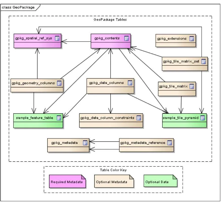
A GeoPackage is a platform-independent SQLite [5] database file that contains GeoPackage data and metadata tables shown in GeoPackage Tables Overview below, with specified definitions, integrity assertions, format limitations and content constraints. The allowable content of a GeoPackage is entirely defined in this standard.
A GeoPackage MAY be “empty” (contain user data table(s) for vector features and/or tile matrix pyramids with no row record content) or contain one or many vector feature type records and /or one or many tile matrix pyramid tile images. GeoPackage metadata CAN describe GeoPackage data contents and identify external data synchronization sources and targets. A GeoPackage MAY contain spatial indexes on feature geometries and SQL triggers to maintain indexes and enforce content constraints.
A GeoPackage SQLite Configuration consists of the SQLite 3 software library and a set of compile- and runtime configurations options.
A GeoPackage SQLite Extension is a SQLite loadable extension that MAY provide SQL functions [12] to support spatial indexes and SQL triggers linked to a SQLite library with specified configuration requirements to provide SQL API [1] [2] [3] [4] access to a
GeoPackage file. This standard does not address the issues listed in the [_potential_future_work] clause in Background and Context (Normative), which MAY be addressed in a subsequent version of this standard or by other specifications.
Figure 1. GeoPackage Tables Overview
1. Base
The required capabilities specified in this clause serve as the base for options specified in clause Options and extensions specified in clause Registered Extensions (Normative). All gpkg_* tables and views and all tiles user data tables specified in this standard SHALL have only the specified columns and table constraints. Any features user data tables MAY have columns in addition to those specified. All specified table, view, column, trigger, and constraint name values SHALL be lowercase.
1.1. Core
The mandatory core capabilities defined in sub clauses and requirement statements of this clause SHALL be implemented by every
1.1.1. SQLite Container
The SQLite software library provides a self-contained, single-file, cross-platform, serverless, transactional, open source RDBMS
container. The GeoPackage standard defines a SQL database schema designed for use with the SQLite software library. Using SQLite as the basis for GeoPackage simplifies production, distribution and use of GeoPackages and assists in guaranteeing the integrity of the data they contain.
“Self-contained” means that container software requires very minimal support from external libraries or from the operating system. “Single-file” means that a container not currently opened by any software application consists of a single file in a file system supported by a computing platform operating system. “Cross-platform” means that a container file MAY be created and loaded with data on one computing platform, and used and updated on another, even if they use different operating systems, file systems, and byte order
(endian) conventions. “Serverless” means that the RDBMS container is implemented without any intermediary server process, and accessed directly by application software. “Transactional” means that RDBMS transactions guarantee that all changes to data in the container are Atomic, Consistent, Isolated, and Durable (ACID) despite program crashes, operating system crashes, and power failures.
1.1.1.1. Data
1.1.1.1.1. File Format
Requirement 1
A GeoPackage SHALL be a SQLite (http://www.sqlite.org/) [5] database file using version 3 of the SQLite file format
(http://sqlite.org/fileformat2.html) [6] [7]. The first 16 bytes of a GeoPackage SHALL contain “SQLite format 3” [1] in ASCII [B4]. [2]
Requirement 2
A GeoPackage SHALL contain 0x47503131 ("GP11" in ASCII) in the application id field of the SQLite database header to indicate a GeoPackage version 1.1 file. [3]
The maximum size of a GeoPackage file is about 140TB. In practice a lower size limit MAY be imposed by the filesystem to which the file is written. Many mobile devices require external memory cards to be formatted using the FAT32 file system which imposes a
maximum size limit of 4GB. 1.1.1.1.2. File Extension Name
Requirement 3
A GeoPackage SHALL have the file extension name “.gpkg”.
It is RECOMMENDED that Extended GeoPackages use the file extension “.gpkx”, but this is NOT a GeoPackage requirement. 1.1.1.1.3. File Contents
Requirement 4
A GeoPackage SHALL only contain data elements, SQL constructs and GeoPackage extensions with the “gpkg” author name specified in this encoding standard.
In order to guarantee maximum interoperability between applications, GeoPackages SHALL NOT contain data elements (tables or columns), SQL constructs (data types, indexes, constraints or triggers) or extensions that are not specified in this encoding standard. SQLite databases that use constructs from the GeoPackage standard but extend those constructs to contain elements not specified in the core GeoPackage standard are referred to as Extended GeoPackages throughout this standard.
Requirement 5
The columns of tables in a GeoPackage SHALL only be declared using one of the data types specified in table GeoPackage Data Types.
Table 1. GeoPackage Data Types
Data Type Size and Description
TINYINT 8-bit signed two’s complement integer. Stored as SQLite INTEGER with values in the range [-128, 127] SMALLINT 16-bit signed two’s complement integer. Stored as SQLite INTEGER with values in the range [-32768,
32767]
MEDIUMINT 32-bit signed two’s complement integer. Stored as SQLite INTEGER with values in the range [-2147483648, 2147483647]
INT, INTEGER 64-bit signed two’s complement integer. Stored as SQLite INTEGER with values in the range [-9223372036854775808, 9223372036854775807]
FLOAT 32-bit IEEE floating point number. Stored as SQLite REAL limited to values that can be represented as a 4-byte IEEE floating point number
DOUBLE, REAL 64-bit IEEE floating point number. Stored as SQLite REAL
TEXT{(maxchar_count)} Variable length string encoded in either UTF-8 or UTF-16, determined by PRAGMA encoding; see http://www.sqlite.org/pragma.html#pragma_encoding
(http://www.sqlite.org/pragma.html#pragma_encoding). The optional maxchar_count defines the maximum number of characters in the string. If not specified, the length is unbounded. The count is provided for informational purposes, and applications MAY choose to truncate longer strings if
encountered. When present, it is best practice for applications to adhere to the character count. Stored as SQLite TEXT
BLOB{(max_size)} Variable length binary data. The optional max_size defines the maximum number of bytes in the blob. If not specified, the length is unbounded. The size is provided for informational purposes. When present, it is best practice for applications adhere to the maximum blob size. Stored as SQLite BLOB
<geometry_type_name> Geometry encoded as per clause Geometry Encoding. <geometry type_name> is one of the geometry types listed in Geometry Types (Normative) encoded per clause 2.1.3 or a user-defined geometry type encoded per clause 3.1.2 and User Defined Geometry Types Extension of GeoPackageBinary Geometry Encoding. Geometry Types XY, XYZ, XYM and XYZM geometries use the same data type. Stored as SQLite BLOB
DATE ISO-8601 date string in the form YYYY-MM-DD encoded in either UTF-8 or UTF-16. See TEXT. Stored as SQLite TEXT
DATETIME ISO-8601 date/time string in the form YYYY-MM-DDTHH:MM:SS.SSSZ with T separator character and Z suffix for coordinated universal time (UTC) encoded in either UTF-8 or UTF-16. See TEXT. Stored as
SQLite TEXT
1.1.1.1.4. File Integrity
Requirement 6
The SQLite PRAGMA integrity_check SQL command SHALL return “ok” for a GeoPackage file. [4]
Requirement 7
The SQLite PRAGMA foreign_key_check SQL with no parameter value SHALL return an empty result set indicating no invalid foreign key values for a GeoPackage file.
1.1.1.2. API
1.1.1.2.1. Structured Query Language (SQL)
Requirement 8
A GeoPackage SQLite Configuration SHALL provide SQL access to GeoPackage contents via SQLite version 3 (http://www.sqlite.org/download.html) [6] software APIs. [5]
The SQLite (http://www.sqlite.org/download.html) [8] library has many compile time (http://www.sqlite.org/compile.html) and run time (http://www.sqlite.org/pragma.html) options that MAY be used to configure SQLite for different uses. Certain elements of the
GeoPackage specification depend on the availability of SQLite functionality at runtime. This clause specifies the set of compile time options that SHALL or SHALL NOT be used.
Requirement 9
Every GeoPackage SQLite Configuration SHALL have the SQLite library compile time options specified in clause 1.1.1.2.2 table Every GeoPackage SQLite Configuration.
Table 2. Every GeoPackage SQLite Configuration
Setting Option Shall
/ Not
Discussion
compile SQLITE_OMIT_* Not SHALL NOT include any OMIT options from http://www.sqlite.org/compile.html#omitfeatures (http://www.sqlite.org/compile.html#omitfeatures).
1.1.2. Spatial Reference Systems
1.1.2.1. Data
1.1.2.1.1. Table Definition
Requirement 10
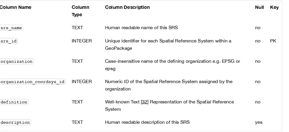
A GeoPackage SHALL include a gpkg_spatial_ref_sys table per clause 1.1.2.1.1 Table Definition, Table Spatial Ref Sys Table Definition and Table gpkg_spatial_ref_sys Table Definition SQL.
A table named gpkg_spatial_ref_sys is the first component of the standard SQL schema for simple features described in clause Simple Features SQL Introduction below. The coordinate reference system definitions it contains are referenced by the GeoPackage
gpkg_contents and gpkg_geometry_columns tables to relate the vector and tile data in user tables to locations on the earth.
The gpkg_spatial_ref_sys table includes the columns specified in SQL/MM (ISO 13249-3) [12] and shown in Spatial Ref Sys Table Definition below containing data that defines spatial reference systems. Views of this table MAY be used to provide compatibility with the SQL/MM (http://www.iso.org/iso/home/store/catalogue_ics/catalogue_detail_ics.htm?csnumber=53698) [12] (see SQL/MM View of gpkg_spatial_ref_sys Definition SQL (Informative)) and OGC Simple Features SQL (http://portal.opengeospatial.org/files/?
artifact_id=25354) [9][10][11] (Table 21) specifications.
Table 3. Spatial Ref Sys Table Definition
Column Name Column
Type
Column Description Null Key
srs_name TEXT Human readable name of this SRS no
srs_id INTEGER Unique identifier for each Spatial Reference System within a GeoPackage
no PK
organization TEXT Case-insensitive name of the defining organization e.g. EPSG or epsg
no
organization_coordsys_id INTEGER Numeric ID of the Spatial Reference System assigned by the organization
no
definition TEXT Well-known Text [32] Representation of the Spatial Reference System
no
description TEXT Human readable description of this SRS yes
Definition column WKT values in the gpkg_spatial_ref_sys table SHALL define the Spatial Reference Systems used by feature geometries and tile images, unless these SRS are unknown and therefore undefined as specified in Requirement 11. Values SHALL be constructed per the EBNF syntax in [32] clause 7. EBNF name and number values MAY be obtained from any specified authority, e.g. [13][14]. For example, see the return value in [spatial_ref_sys_data_values_default] Test Method step (3) used to test the definition for WGS-84 per Requirement 11:
Requirement 11
The gpkg_spatial_ref_sys table SHALL contain at a minimum the records listed in Spatial Ref Sys Table Records. The record with an srs_id of 4326 SHALL correspond to WGS-84 (http://www.google.com/search?as_q=WGS-84) [15] as defined by EPSG (http://www.epsg.org/Geodetic.html) [B3] in 4326 (http://www.epsg-registry.org/report.htm?
type=selection&entity=urn:ogc:def:crs:EPSG::4326&reportDetail=long&title=WGS%2084&style=urn:uuid:report-style:default-with-code&style_name=OGP%20Default%20With%20Code) [13][14]. The record with an srs_id of -1 SHALL be used for undefined Cartesian coordinate reference systems. The record with an srs_id of 0 SHALL be used for undefined geographic coordinate reference systems.
Table 4. Spatial Ref Sys Table Records
srs_name srs_id organization organization_coordsys_id definition description
any 4326 EPSG or epsg 4326 any any
any -1 NONE -1 undefined any
any 0 NONE 0 undefined any
Requirement 12
The gpkg_spatial_ref_sys table in a GeoPackage SHALL contain records to define all spatial reference systems used by features and tiles in a GeoPackage.
1.1.3. Contents
1.1.3.1. Data
1.1.3.1.1. Table Definition
Requirement 13
A GeoPackage file SHALL include a gpkg_contents table per table Contents Table or View Definition and gpkg_contents Table Definition SQL.
The purpose of the gpkg_contents table is to provide identifying and descriptive information that an application can display to a user in a menu of geospatial data that is available for access and/or update.
Table 5. Contents Table or View Definition
Column
Name
Type Description Null Default Key
table_name TEXT The name of the tiles, or feature table
no PK
data_type TEXT Type of data stored in the table:. “features” per clause Features, “tiles” per clause Tiles, or an
implementer-defined value for other data tables per clause in an
Extended GeoPackage.
no
A human-readable identifier (e.g. short name) for the table_name content
description TEXT A human-readable description for the table_name content
yes ''
last_change DATETIME timestamp value in ISO 8601 format as defined by the strftime function %Y-%m-%dT%H:%M:%fZ format string applied to the current time
no strftime('%Y-%m-%dT%H:%M:%fZ', 'now')
min_x DOUBLE Bounding box minimum easting or longitude for all content in
table_name
yes
min_y DOUBLE Bounding box minimum northing or latitude for all content in table_name
yes
max_x DOUBLE Bounding box maximum easting or longitude for all content in
table_name
yes
max_y DOUBLE Bounding box maximum northing or latitude for all content in table_name
yes
srs_id INTEGER Spatial Reference System ID:
gpkg_spatial_ref_sys.srs_id ; when data_type is features,
SHALL also match
gpkg_geometry_columns.srs_id ; When data_type is tiles, SHALL also match
gpkg_tile_matrix_set.srs_id
yes FK
The gpkg_contents table is intended to provide a list of all geospatial contents in a GeoPackage. The data_type specifies the type of content. The bounding box ( min_x, min_y, max_x, max_y ) provides an informative bounding box (not necessarily minimum
bounding box) of the content. If the srs_id column value references a geographic coordinate reference system (CRS), then the min/max x/y values are in decimal degrees; otherwise, the srs_id references a projected CRS and the min/max x/y values are in the units specified by that CRS.
See gpkg_contents Table Definition SQL. 1.1.3.1.2. Table Data Values
Requirement 14
The table_name column value in a gpkg_contents table row SHALL contain the name of a SQLite table or view.
Requirement 15
Values of the gpkg_contents table last_change column SHALL be in ISO 8601 (http://www.iso.org/iso/catalogue_detail? csnumber=40874) [29] format containing a complete date plus UTC hours, minutes, seconds and a decimal fraction of a second, with a ‘Z’ (‘zulu’) suffix indicating UTC. [6]
Requirement 16
Values of the gpkg_contents table srs_id column SHALL reference values in the gpkg_spatial_ref_sys table srs_id
2. Options
The optional capabilities specified in this clause depend on the required capabilities specified in clause Base above. Each subclause of this clause defines an indivisible module of functionality that can be used in GeoPackages. These modules are referred to as options. GeoPackages MAY use one or more options defined in this section. GeoPackages MAY omit the tables for options that are not used. As a minimum, a GeoPackage SHALL contain one user data table as defined by the Features or Tiles options in clauses Features and Tiles respectively.
Requirement 17
A GeoPackage SHALL contain features per clause Features and/or tiles per clause Tiles and row(s) in the gpkg_contents table with lowercase data_type column values of “features” and/or “tiles” describing the user data tables.
2.1. Features
2.1.1. Simple Features SQL Introduction
Vector feature data represents geolocated entities including conceptual ones such as districts, real world objects such as roads and rivers, and observations thereof. International standards [9][10][11][12] have standardized practices for the storage, access and use of vector geospatial features and geometries via SQL in relational databases. The first component of the SQL schema for vector features in a GeoPackage is the gpkg_spatial_ref_sys table defined in clause Spatial Reference Systems above. Other components are defined below.
In a GeoPackage, “simple” features are geolocated using a linear geometry subset of the SQL/MM (ISO 13249-3) [12] geometry model shown in Core Geometry Model below.
Figure 2. Core Geometry Model
The instantiable (not abstract) geometry types defined in this Standard are restricted to 0, 1 and 2-dimensional geometric objects that exist in 2, 3 or 4-dimensional coordinate space (R2, R3 or R4). Geometry values in R2 have points with coordinate values for x and y. Geometry values in R3 have points with coordinate values for x, y and z or for x, y and m. Geometry values in R4 have points with coordinate values for x, y, z and m. The interpretation of the coordinates is subject to the coordinate reference systems associated to the point. All coordinates within a geometry object should be in the same coordinate reference systems.
Geometries MAY include z coordinate values. The z coordinate value traditionally represents the third dimension (i.e. 3D). In a
Geometries MAY include m coordinate values. The m coordinate value allows the application environment to associate some measure with the point values. For example: A stream network may be modeled as multilinestring value with the m coordinate values measuring the distance from the mouth of stream.
All geometry types described in this standard are defined so that instances of Geometry are topologically closed, i.e. all represented geometries include their boundary as point sets. This does not affect their representation, and open version of the same classes MAY be used in other circumstances, such as topological representations.
A brief description of each geometry type is provided below. A more detailed description can be found in ISO 13249-3 [12].
Geometry: the root of the geometry type hierarchy.
Point: a single location in space. Each point has an X and Y coordinate. A point MAY optionally also have a Z and/or an M value. Curve: the base type for all 1-dimensional geometry types. A 1-dimensional geometry is a geometry that has a length, but no area. A curve is considered simple if it does not intersect itself (except at the start and end point). A curve is considered closed its start and end point are coincident. A simple, closed curve is called a ring.
LineString: A Curve that connects two or more points in space.
Surface: the base type for all 2-dimensional geometry types. A 2-dimensional geometry is a geometry that has an area.
CurvePolygon: A planar surface defined by an exterior ring and zero or more interior ring. Each ring is defined by a Curve instance. Polygon: A restricted form of CurvePolygon where each ring is defined as a simple, closed LineString.
GeometryCollection: A collection of zero or more Geometry instances. [7]
MultiSurface: A restricted form of GeometryCollection where each Geometry in the collection must be of type Surface. MultiPolygon: A restricted form of MultiSurface where each Surface in the collection must be of type Polygon.
MultiCurve: A restricted form of GeometryCollection where each Geometry in the collection must be of type Curve. MultiLineString: A restricted form of MultiCurve where each Curve in the collection must be of type LineString. MultiPoint: A restricted form of GeometryCollection where each Geometry in the collection must be of type Point.
2.1.2. Contents
2.1.2.1. Data
2.1.2.1.1. Contents Table – Features Row
Requirement 18
The gpkg_contents table SHALL contain a row with a lowercase data_type column value of “features” for each vector features user data table or view.
2.1.3. Geometry Encoding
2.1.3.1. Data
2.1.3.1.1. BLOB Format
Requirement 19
A GeoPackage SHALL store feature table geometries with or without optional elevation (Z) and/or measure (M) values in SQL BLOBs using the Standard GeoPackageBinary format specified in table GeoPackage SQL Geometry Binary Format and clause BLOB Format.
GP in ASCII
8-bit unsigned integer, 0 = version 1
see bit layout of GeoPackageBinary flags byte see flags envelope contents indicator code below The X bit in the header flags field must be set to 0. per OGC 06-103r4 [9] [8][9][10]
Table 6. bit layout of GeoPackageBinary flags byte
bit 7 6 5 4 3 2 1 0
use R R X Y E E E B
flag bits use:
R: reserved for future use; set to 0 X: GeoPackageBinary type
0: StandardGeoPackageBinary. See below
1: ExtendedGeoPackageBinary. See User Defined Geometry Types Extension of GeoPackageBinary Geometry Encoding. Y: empty geometry flag
0: non-empty geometry 1: empty geometry
E: envelope contents indicator code (3-bit unsigned integer) 0: no envelope (space saving slower indexing option), 0 bytes 1: envelope is [minx, maxx, miny, maxy], 32 bytes
2: envelope is [minx, maxx, miny, maxy, minz, maxz], 48 bytes 3: envelope is [minx, maxx, miny, maxy, minm, maxm], 48 bytes
4: envelope is [minx, maxx, miny, maxy, minz, maxz, minm, maxm], 64 bytes 5-7: invalid
B: byte order for header values (1-bit Boolean) 0: Big Endian (most significant byte first) 1: Little Endian (least significant byte first)
Well-Known Binary as defined in OGC 06-103r4 [9] does not provide a standardized encoding for an empty point set (i.e., Point Empty in Well-Known Text). In GeoPackages these points SHALL be encoded as a Point where each coordinate value is set to an IEEE-754 quiet NaN value. GeoPackages SHALL use big endian 0x7ff8000000000000 or little endian 0x000000000000f87f as the binary encoding of the NaN values.
When the WKBGeometry in a GeoPackageBinary is empty, either the envelope contents indicator code SHALL be 0 indicating no envelope, or the envelope SHALL have its values set to NaN as defined for an empty point.
2.1.4. SQL Geometry Types
2.1.4.1. Data
2.1.4.1.1. Core Types
Requirement 20
A GeoPackage SHALL store feature table geometries with the basic simple feature geometry types (Geometry, Point, LineString, Polygon, MultiPoint, MultiLineString, MultiPolygon, GeomCollection) in Geometry Types (Normative) Geometry Type Codes (Core) in the GeoPackageBinary geometry encoding format.
2.1.5. Geometry Columns
2.1.5.1. Data
2.1.5.1.1. Table Definition
Requirement 21
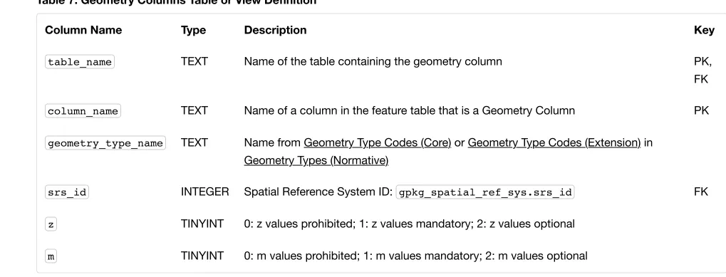
A GeoPackage with a gpkg_contents table row with a “features” data_type SHALL contain a gpkg_geometry_columns
table or updateable view per Geometry Columns Table or View Definition and gpkg_geometry_columns Table Definition SQL.
The second component of the SQL schema for vector features in a GeoPackage is a gpkg_geometry_columns table that identifies the geometry columns and geometry types in tables that contain user data representing features.
Table 7. Geometry Columns Table or View Definition
Column Name Type Description Key
table_name TEXT Name of the table containing the geometry column PK, FK
column_name TEXT Name of a column in the feature table that is a Geometry Column PK
geometry_type_name TEXT Name from Geometry Type Codes (Core) or Geometry Type Codes (Extension) in Geometry Types (Normative)
srs_id INTEGER Spatial Reference System ID: gpkg_spatial_ref_sys.srs_id FK
z TINYINT 0: z values prohibited; 1: z values mandatory; 2: z values optional
m TINYINT 0: m values prohibited; 1: m values mandatory; 2: m values optional
The FK on gpkg_geometry_columns.srs_id references the PK on gpkg_spatial_ref_sys.srs_id to ensure that geometry columns are only defined in feature tables for defined spatial reference systems.
Views of this table or view MAY be used to provide compatibility with the SQL/MM [12] SQL/MM View of gpkg_geometry_columns Definition SQL (Informative) and OGC Simple Features SQL [9][10][11] SF/SQL VIEW of gpkg_geometry_columns Definition SQL (Informative) specifications.
See gpkg_geometry_columns Table Definition SQL. 2.1.5.1.2. Table Data Values
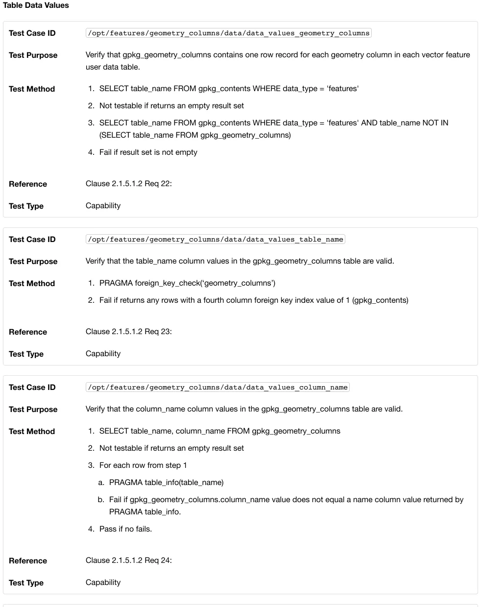
Requirement 22
The gpkg_geometry_columns table or updateable view SHALL contain one row record for the geometry column in each vector feature data table (clause Vector Feature User Data Tables) in a GeoPackage.
Values of the gpkg_geometry_columns table_name column SHALL reference values in the gpkg_contents table_name
column for rows with a data_type of features.
Requirement 24
The column_name column value in a gpkg_geometry_columns row SHALL be the name of a column in the table or view specified by the table_name column value for that row.
Requirement 25
The geometry_type_name value in a gpkg_geometry_columns row SHALL be one of the uppercase geometry type names specified in Geometry Types (Normative).
Requirement 26
The srs_id value in a gpkg_geometry_columns table row SHALL be an srs_id column value from the
gpkg_spatial_ref_sys table.
Requirement 27
The z value in a gpkg_geometry_columns table row SHALL be one of 0, 1, or 2.
Requirement 28
The m value in a gpkg_geometry_columns table row SHALL be one of 0, 1, or 2.
2.1.6. Vector Feature User Data Tables
2.1.6.1. Data
2.1.6.1.1. Table Definition
The third component of the SQL schema for vector features in a GeoPackage described in clause Simple Features SQL Introduction above are tables that contain user data representing features. Feature attributes are columns in a feature table, including geometries. Features are rows in a feature table. [11]
Requirement 29
A GeoPackage MAY contain tables or updateable views containing vector features. Every such feature table or view in a
GeoPackage SHALL have a column with column type INTEGER and PRIMARY KEY AUTOINCREMENT column constraints per EXAMPLE : Sample Feature Table or View Definition and sample_feature_table Table Definition SQL (Informative).
The integer primary key of a feature table allows features to be linked to row level metadata records in the gpkg_metadata table by rowid [B5] values in the gpkg_metadata_reference table as described in clause Metadata Reference Table below.
Requirement 30
A feature table SHALL have only one geometry column.
Feature data models [B23] from non-GeoPackage implementations that have multiple geometry columns per feature table MAY be
transformed into GeoPackage implementations with a separate feature table for each geometry type whose rows have matching integer primary key values that allow them to be joined in a view with the same column definitions as the non-GeoPackage feature data model with multiple geometry columns.
Requirement 31
The declared SQL type of the geometry column in a vector feature user data table SHALL be the uppercase geometry type name from Annex G specified by the geometry_type_name column for that column_name and table_name in the
gpkg_geometry_columns table.
Column Name Type Description Null Default Key
id INTEGER Autoincrement primary key no PK
geometry GEOMETRY GeoPackage Geometry yes
text_attribute TEXT Text attribute of feature yes
real_attribute REAL Real attribute of feature yes
boolean_attribute BOOLEAN Boolean attribute of feature yes
raster_or_photo BLOB Photograph of the area yes
See sample_feature_table Table Definition SQL (Informative). 2.1.6.1.2. Table Data Values
A feature geometry is stored in a geometry column specified by the geometry_column value for the feature table in the
gpkg_geometry_columns table defined in clause Geometry Columns above.
The geometry type of a feature geometry column specified in the gpkg_geometry_columns table geometry_type_name column is a name from Geometry Types (Normative).
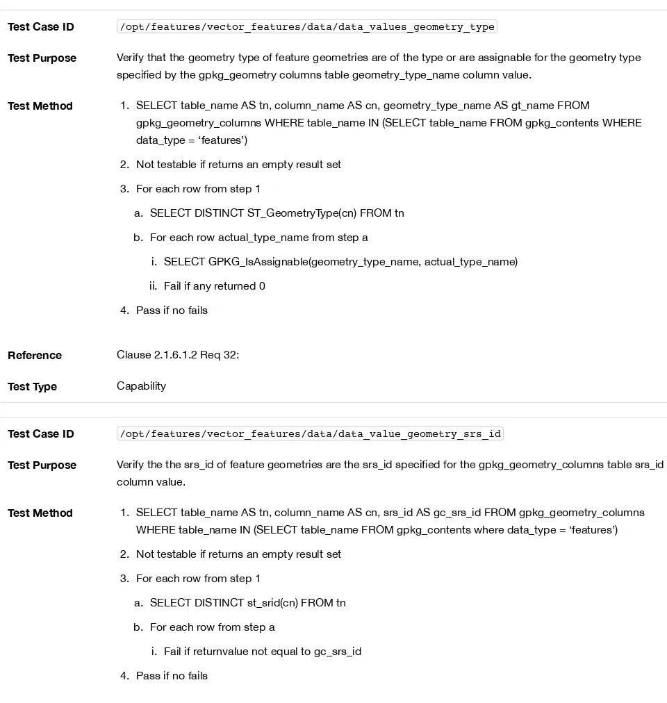
Requirement 32
Feature table geometry columns SHALL contain geometries of the type or assignable for the type specified for the column by the
gpkg_geometry_columns table geometry_type_name uppercase column value [12].
Geometry subtypes are assignable as defined in Geometry Types (Normative) and shown in part in Core Geometry Model. For example, if the geometry_type_name value in the gpkg_geometry_columns table is for a geometry type like POINT that has no subtypes, then the feature table geometry column MAY only contain geometries of that type. If the geometry type_name value in the
gpkg_geometry_columns table is for a geometry type like GEOMCOLLECTION that has subtypes, then the feature table geometry column MAY only contain geometries of that type or any of its direct or indirect subtypes. If the geometry type_name is GEOMETRY (the root of the geometry type hierarchy) then the feature table geometry column MAY contain geometries of any geometry type.
The presence or absence of optional elevation (Z) and/or measure (M) values in a geometry does not change its type or assignability. The unit of measure for optional elevation(Z) values is determined by the CRS of the geometry; it is as-defined by a 3D CRS, and undefined for a 2D CRS. The unit of measure for optional measure (M) values is determined by the CRS of the geometry.
The spatial reference system type of a feature geometry column specified by a gpkg_geometry_columns table srs_id column value is a code from the gpkg_spatial_ref_sys table srs_id column.
Requirement 33
Feature table geometry columns SHALL contain geometries with the srs_id specified for the column by the
gpkg_geometry_columns table srs_id column value.
2.2. Tiles
2.2.1. Tile Matrix Introduction
There are a wide variety of commercial and open source conventions for storing, indexing, accessing and describing tiles in tile
pyramids. Unfortunately, no applicable existing consensus, national or international specifications have standardized practices in this domain. In addition, various image file formats have different representational capabilities, and include different self-descriptive
metadata.
level to allow applications that use GeoPackage data to discover its characteristics without having to parse all of the stored images. Applications that store GeoPackage tile data, which are presumed to have this information available, SHALL store sufficient metadata to enable its intended use.
The GeoPackage tile store data model MAY be implemented directly as SQL tables in a SQLite database for maximum performance, or as SQL views on top of tables in an existing SQLite tile store for maximum adaptability and loose coupling to enable widespread
implementation.
A GeoPackage CAN store multiple raster and tile pyramid data sets in different tables or views in the same container. [13] “Tile pyramid” refers to the concept of pyramid structure of tiles of different spatial extent and resolution at different zoom levels, and the tile data
itself. “Tile matrix” refers to rows and columns of tiles that all have the same spatial extent and resolution at a particular zoom level. “Tile matrix set” refers to the definition of a tile pyramid’s tiling structure.
The tables or views that implement the GeoPackage tile store data / metadata model are described and discussed individually in the following subsections.
2.2.2. Contents
2.2.2.1. Data
2.2.2.1.1. Contents Table – Tiles Row
Requirement 34
The gpkg_contents table SHALL contain a row with a data_type column value of “tiles” for each tile pyramid user data table or view.
2.2.3. Zoom Levels
In a GeoPackage, zoom levels are integers in sequence from 0 to n that identify tile matrix layers in a tile matrix set that contain tiles of decreasing spatial extent and finer spatial resolution. Adjacent zoom levels immediately preceed or follow each other and differ by a value of 1. Pixel sizes are real numbers in the terrain units of the spatial reference system of a tile image specifying the dimensions of the real world area represented by one pixel. Pixel size MAY vary by a constant factor or by different factors or intervals between some or all adjacent zoom levels in a tile matrix set. In the commonly used "zoom times two" convention, pixel sizes vary by a factor of 2 between all adjacent zoom levels, as shown in the example in Tiles Zoom Times Two Example (Informative). Other "zoom other
intervals" conventions use different factors or irregular intervals with pixel sizes chosen for intuitive cartographic representation of raster data, or to coincide with the original pixel size of commonly used global image products. See Web Map Tile Service (WMTS) [16] Annex E for additional examples of both conventions.
2.2.3.1. Data
2.2.3.1.1. Zoom Times Two
Requirement 35
In a GeoPackage that contains a tile pyramid user data table that contains tile data, by default [14], zoom level pixel sizes for that table SHALL vary by a factor of 2 between adjacent zoom levels in the tile matrix metadata table.
2.2.4. Tile Encoding PNG
2.2.4.1. Data
2.2.4.1.1. MIME Type PNG
Requirement 36
In a GeoPackage that contains a tile pyramid user data table that contains tile data that is not MIME type
(http://www.ietf.org/rfc/rfc2046.txt) image/jpeg (http://www.jpeg.org/public/jfif.pdf) [17][18][19], by default SHALL store that tile data in MIME type (http://www.iana.org/assignments/media-types/index.html) image/png (http://libpng.org/pub/png/) [20][21]. [15]
2.2.5. Tile Encoding JPEG
2.2.5.1. Data
2.2.5.1.1. MIME Type JPEG
In a GeoPackage that contains a tile pyramid user data table that contains tile data that is not MIME type
(http://www.iana.org/assignments/media-types/index.html) image/png (http://libpng.org/pub/png/) [20][21], by default SHALL store that tile data in MIME type (http://www.ietf.org/rfc/rfc2046.txt) image/jpeg (http://www.jpeg.org/public/jfif.pdf) [17][18][19]. [16]
2.2.6. Tile Matrix Set
2.2.6.1. Data
2.2.6.1.1. Table Definition
Requirement 38
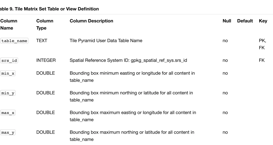
A GeoPackage that contains a tile pyramid user data table SHALL contain gpkg_tile_matrix_set table or view per Table Definition, Tile Matrix Set Table or View Definition and gpkg_tile_matrix_set Table Creation SQL.
Table 9. Tile Matrix Set Table or View Definition
Column
Name
Column
Type
Column Description Null Default Key
table_name TEXT Tile Pyramid User Data Table Name no PK,
FK
srs_id INTEGER Spatial Reference System ID: gpkg_spatial_ref_sys.srs_id no FK
min_x DOUBLE Bounding box minimum easting or longitude for all content in table_name
no
min_y DOUBLE Bounding box minimum northing or latitude for all content in table_name
no
max_x DOUBLE Bounding box maximum easting or longitude for all content in table_name
no
max_y DOUBLE Bounding box maximum northing or latitude for all content in table_name
no
The gpkg_tile_matrix_set table or updateable view defines the spatial reference system (srs_id) and the maximum bounding box (min_x, min_y, max_x, max_y) for all possible tiles in a tile pyramid user data table. All tiles present in the tile pyramid SHALL fall within this
bounding box. However, the bounding box MAY be larger than the minimum bounding rectangle around the actual tiles in that pyramid.
See gpkg_tile_matrix_set Table Creation SQL. 2.2.6.1.2. Table Data Values
The minimum bounding box defined in the gpkg_tile_matrix_set table or view for a tile pyramid user data table SHALL be exact so that the bounding box coordinates for individual tiles in a tile pyramid MAY be calculated based on the column values for the user data table in the gpkg_tile_matrix table or view. For example, because GeoPackages use the upper left tile origin convention defined in clause Table Data Values below, the gpkg_tile_matrix_set (min_x, max_y) ordinate is the upper-left corner of tile (0,0) for all zoom levels in a table_name tile pyramid user data table.
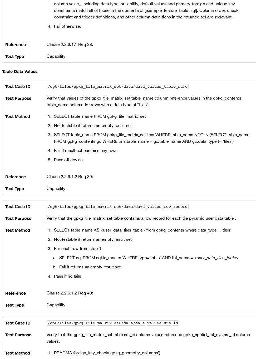
Requirement 39
Values of the gpkg_tile_matrix_set table_name column SHALL reference values in th gpkg_contents table_name column for rows with a data type of "tiles".
Requirement 40
The gpkg_tile_matrix_set table or view SHALL contain one row record for each tile pyramid user data table.
Values of the gpkg_tile_matrix_set srs_id column SHALL reference values in the gpkg_spatial_ref_sys srs_id
column.
2.2.7. Tile Matrix
2.2.7.1. Data
2.2.7.1.1. Table Definition
Requirement 42
A GeoPackage that contains a tile pyramid user data table SHALL contain a gpkg_tile_matrix table or view per clause 2.2.7.1.1 Table Definition, Table Tile Matrix Metadata Table or View Definition and Table gpkg_tile_matrix Table Creation SQL.
Table 10. Tile Matrix Metadata Table or View Definition
Column Name Column Type Column Description Null Key
table_name TEXT Tile Pyramid User Data Table Name no PK, FK
zoom_level INTEGER 0 zoom_level max_level for table_name no PK
matrix_width INTEGER Number of columns (>= 1) in tile matrix at this zoom level no
matrix_height INTEGER Number of rows (>= 1) in tile matrix at this zoom level no
tile_width INTEGER Tile width in pixels (>= 1)for this zoom level no
tile_height INTEGER Tile height in pixels (>= 1) for this zoom level no
pixel_x_size DOUBLE In t_table_name srid units or default meters for srid 0 (>0) no
pixel_y_size DOUBLE In t_table_name srid units or default meters for srid 0 (>0) no
The gpkg_tile_matrix table or updateable view documents the structure of the tile matrix at each zoom level in each tiles table. It allows GeoPackages to contain rectangular as well as square tiles (e.g. for better representation of polar regions). It allows tile pyramids with zoom levels that differ in resolution by factors of 2, irregular intervals, or regular intervals other than factors of 2.
See gpkg_tile_matrix Table Creation SQL 2.2.7.1.2. Table Data Values
Requirement 43
Values of the gpkg_tile_matrix table_name column SHALL reference values in the gpkg_contents table_name column for rows with a data_type of “tiles”.
Requirement 44
The gpkg_tile_matrix table or view SHALL contain one row record for each zoom level that contains one or more tiles in each tile pyramid user data table or view.
Requirement 45
The width of a tile matrix (the difference between min_x and max_x in gpkg_tile_matrix_set ) SHALL equal the product of
matrix_width , tile_width , and pixel_x_size for that zoom level. Similarly, height of a tile matrix (the difference between
min_y and max_y in gpkg_tile_matrix_set ) SHALL equal the product of matrix_height, tile_height, and
pixel_y_size for that zoom level.
GeoPackages follow the most frequently used conventions of a tile origin at the upper left and a zoom-out-level of 0 for the smallest map scale “whole world” zoom level view [17], as specified by WMTS (http://portal.opengeospatial.org/files/?artifact_id=35326) [16]. The tile coordinate (0,0) always refers to the tile in the upper left corner of the tile matrix at any zoom level, regardless of the actual availability of that tile.
Requirement 46
The zoom_level column value in a gpkg_tile_matrix table row SHALL not be negative.
Requirement 47
The matrix_width column value in a gpkg_tile_matrix table row SHALL be greater than 0.
Requirement 48
The matrix_height column value in a gpkg_tile_matrix table row SHALL be greater than 0.
Requirement 49
The tile_width column value in a gpkg_tile_matrix table row SHALL be greater than 0.
Requirement 50
The tile_height column value in a gpkg_tile_matrix table row SHALL be greater than 0.
Requirement 51
The pixel_x_size column value in a gpkg_tile_matrix table row SHALL be greater than 0.
Requirement 52
The pixel_y_size column value in a gpkg_tile_matrix table row SHALL be greater than 0.
Requirement 53
The pixel_x_size and pixel_y_size column values for zoom_level column values in a gpkg_tile_matrix table sorted in ascending order SHALL be sorted in descending order.
Tiles MAY or MAY NOT be provided for level 0 or any other particular zoom level. [18] This means that a tile matrix set can be sparse, i.e. not contain a tile for any particular position at a certain tile zoom level. [19] This does not affect the informative spatial extent stated by the min/max x/y columns values in the gpkg_contents record for the same table_name , the exact spatial extent stated by the
min/max x/y columns values in the gpkg_tile_matrix_set record for the same table name, or the tile matrix width and height at that level. [20]
2.2.8. Tile Pyramid User Data Tables
2.2.8.1. Data
2.2.8.1.1. Table Definition
Requirement 54
Each tile matrix set in a GeoPackage SHALL be stored in a different tile pyramid user data table or updateable view with a unique name that SHALL have a column named "id" with column type INTEGER and PRIMARY KEY AUTOINCREMENT column
constraints per Clause 2.2.8.1.1 Table Definition, Tiles Table or View Definition and EXAMPLE: tiles table Create Table SQL (Informative).
Table 11. Tiles Table or View Definition
Column
Name
Column
Type
id INTEGER Autoincrement primary key no PK
zoom_level INTEGER min(zoom_level) zoom_level max(zoom_level) for t_table_name no 0 UK
tile_column INTEGER 0 to tile_matrix matrix_width – 1 no 0 UK
tile_row INTEGER 0 to tile_matrix matrix_height - 1 no 0 UK
tile_data BLOB Of an image MIME type specified in clauses Tile Encoding PNG, Tile Encoding JPEG, [tile_enc_webp]
no
See EXAMPLE: tiles table Create Table SQL (Informative). 2.2.8.1.2. Table Data Values
Each tile pyramid user data table or view [21] MAY contain tile matrices at zero or more zoom levels of different spatial resolution (map scale).
Requirement 55
For each distinct table_name from the gpkg_tile_matrix (tm) table, the tile pyramid (tp) user data table zoom_level
column value in a GeoPackage SHALL be in the range min(tm.zoom_level) tp.zoom_level max(tm.zoom_level).
Requirement 56
For each distinct table_name from the gpkg_tile_matrix (tm) table, the tile pyramid (tp) user data table tile_column
column value in a GeoPackage SHALL be in the range 0 tp.tile_column tm.matrix_width – 1 where the tm and tp
zoom_level column values are equal.
Requirement 57
For each distinct table_name from the gpkg_tile_matrix (tm) table, the tile pyramid (tp) user data table tile_row column value in a GeoPackage SHALL be in the range 0 tp.tile_row tm.matrix_height – 1 where the tm and tp zoom_level column values are equal.
All tiles at a particular zoom level have the same pixel_x_size and pixel_y_size values specified in the gpkg_tile_matrix row record for that tiles table and zoom level. [22]
2.3. Extension Mechanism
2.3.1. Introduction
A GeoPackage extension is a set of one or more requirements clauses that are documented by filling out the GeoPackage Extension Template in GeoPackage Extension Template (Informative). A GeoPackage Extension either profiles / extends existing requirements clauses in the GeoPackage standard or adds new requirements clauses. Existing requirement clause extension examples include additional geometry types, additional SQL geometry functions, and additional tile image formats. New requirement clause extension examples include spatial indexes, triggers, additional tables, other BLOB column encodings, and other SQL functions.
GeoPackage extensions are identified by a name of the form <author>_<extension name> where <author> indicates the person or organization that developed and maintains the extension. The author value “gpkg” is reserved for GeoPackage extensions that are developed and maintained by OGC and used in GeoPackages. Implementers use their own author names to register other
extensions[23] used in Extended GeoPackages.
2.3.2. Extensions
2.3.2.1. Data
2.3.2.1.1. Table Definition
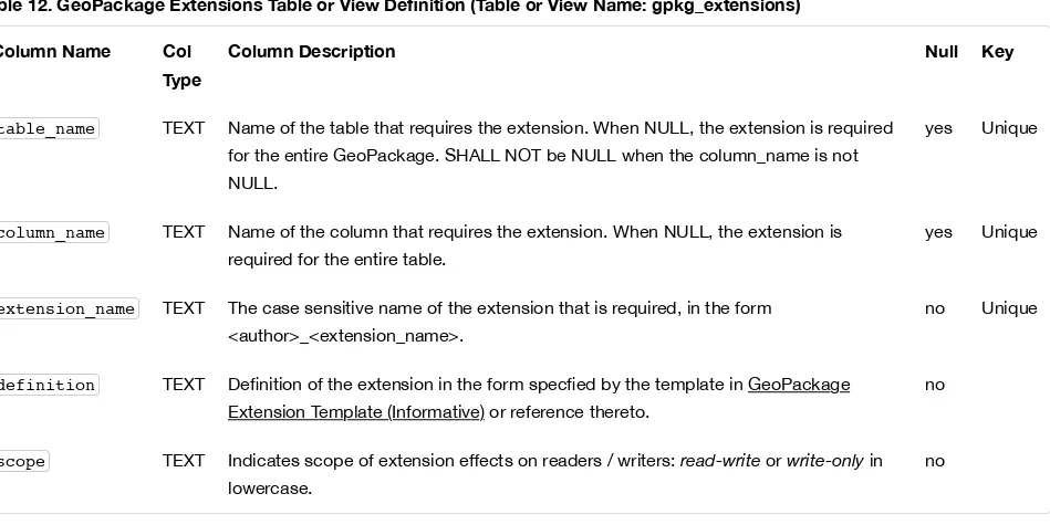
A GeoPackage MAY contain a table or updateable view named gpkg_extensions. If present this table SHALL be defined per clause 2.3.2.1.1 Table Definition, GeoPackage Extensions Table or View Definition (Table or View Name: gpkg_extensions) and gpkg_extensions Table Definition SQL.
The gpkg_extensions table or updateable view in a GeoPackage is used to indicate that a particular extension applies to a
GeoPackage, a table in a GeoPackage or a column of a table in a GeoPackage. An application that accesses a GeoPackage can query the gpkg_extensions table instead of the contents of all the user data tables to determine if it has the required capabilities to read or write to tables with extensions, and to “fail fast” and return an error message if it does not.
Table 12. GeoPackage Extensions Table or View Definition (Table or View Name: gpkg_extensions)
Column Name Col
Type
Column Description Null Key
table_name TEXT Name of the table that requires the extension. When NULL, the extension is required for the entire GeoPackage. SHALL NOT be NULL when the column_name is not NULL.
yes Unique
column_name TEXT Name of the column that requires the extension. When NULL, the extension is required for the entire table.
yes Unique
extension_name TEXT The case sensitive name of the extension that is required, in the form <author>_<extension_name>.
no Unique
definition TEXT Definition of the extension in the form specfied by the template in GeoPackage Extension Template (Informative) or reference thereto.
no
scope TEXT Indicates scope of extension effects on readers / writers: read-write or write-only in lowercase.
no
See gpkg_extensions Table Definition SQL. 2.3.2.1.2. Table Data Values
Requirement 59
Every extension of a GeoPackage SHALL be registered in a corresponding row in the gpkg_extensions table. The absence of a gpkg_extensions table or the absence of rows in the gpkg_extensions table SHALL both indicate the absence of extensions to a GeoPackage.
Requirement 60
Values of the gpkg_extensions table_name column SHALL reference values in the gpkg_contents table_name column or be NULL. They SHALL NOT be NULL for rows where the column_name value is not NULL.
Requirement 61
The column_name column value in a gpkg_extensions row SHALL be the name of a column in the table specified by the
table_name column value for that row, or be NULL.
Requirement 62
Each extension_name column value in a gpkg_extensions row SHALL be a unique case sensitive value of the form
<author>_<extension_name> where <author> indicates the person or organization that developed and maintains the extension. The valid character set for <author> SHALL be [a-zA-Z0-9]. The valid character set for <extension_name> SHALL be [a-zA-Z0-9_]. An extension_name for the “gpkg” author name SHALL be one of those defined in this encoding standard or in an OGC
document (e.g. Best Practices Document or Encoding Standard) that extends it.
Partial examples of how to fill out the GeoPackage Extension Template in GeoPackage Extension Template (Informative) are provided by the templates in GeoPackage Non-Linear Geometry Types and User Defined Geometry Types Extension of GeoPackageBinary Geometry Encoding. Extension definitions created using those template and other extension definitions MAY be provided in the definition column, preferably as ASCII text, or as a reference such as a URI [23] or email address whereby the definition may be obtained.
Requirement 63
The definition column value in a gpkg_extensions row SHALL contain or reference the text that results from documenting an extension by filling out the GeoPackage Extension Template in GeoPackage Extension Template (Informative).
Some extensions do not impose any additional requirements on software that accesses a GeoPackage in a read-only fashion. An example of this is an extension that defines an SQL trigger that uses a non-standard SQL function defined in a GeoPackage SQLite Extension. Triggers are only invoked when data is written to the GeoPackage, so usage of this type of extension can be safely ignored for read-only access. This is indicated by a gpkg_extensions.scope column value of “write_only”.
Requirement 64
The scope column value in a gpkg_extensions row SHALL be lowercase "read-write" for an extension that affects both readers and writers, or "write-only" for an extension that affects only writers.
The author value “gpkg” is reserved for GeoPackage extensions that are developed and maintained by OGC. Requirements for
extension names for the “gpkg” author name are defined in the clauses listed in 14 below. GeoPackage implementers use their own author names to register other extensions.
3. Security Considerations
Security considerations for implementations utilizing GeoPackages are in the domain of the implementing application, deployment platform, operating system and networking environment. The GeoPackage standard does not place any constraints on application, platform, operating system level or network security.
Annex A: Conformance / Abstract Test Suite (Normative)
A.1. Base
A.1.1. Core
A.1.1.1. SQLite Container
A.1.1.1.1. Data
File Format
Test Case ID /base/core/container/data/file_format
Test Purpose Verify that the Geopackage is an SQLite version_3 database
Test Method Pass if the first 16 bytes of the file contain “SQLite format 3” in ASCII.
Reference Clause 1.1.1.1.1 Req 1:
Test Type Basic
Test Case ID /base/core/container/data/file_format/application_id
Test Purpose Verify that the SQLite database header application id field indicates GeoPackage version 1.0
Reference Clause 1.1.1.1.1 Req 2:
Test Type Basic
File Extension Name
Test Case ID /base/core/container/data/file_extension_name
Test Purpose Verify that the geopackage extension is ".gpkg"
Test Method Pass if the geopackage file extension is ".gpkg"
Reference Clause 1.1.1.1.2 Req 3:
Test Type Basic
File Contents
Test Case ID /base/core/container/data/file_contents
Test Purpose Verify that the Geopackage only contains specified contents
Test Method 1. For each gpkg_* table_name
a. PRAGMA table_info(table_name)
b. Continue if returns an empty result set
c. Fail if column definitions returned by PRAGMA table_info do not match column definitions for the table in Annex C.
2. Do test /opt/features/vector_features/data/feature_table_integer_primary_key 3. Do test /opt/features/vector/features/data/feature_table_one_geometry_column 4. Do test /opt/tiles/contents/data/tiles_row
5. SELECT extension_name FROM gpkg_contents 6. For each row from #4
a. Fail if the substring before the first “_” is not “gpkg” 7. Pass if no fails
Reference Clause 1.1.1.1.3 Req 4:
Test Type Basic
Test Case ID /base/core/container/data/table_data_types
Test Purpose Verify that the data types of GeoPackage columns include only the types specified by
[table_column_data_types].
Test Method 1. SELECT table_name FROM gpkg_contents WHERE data_type = ‘features’
2. Not testable if returns empty set
3. For each row table name from step 1 a. PRAGMA table_info(table_name) b. Fail if returns empty set
c. For each row type column value
4. Pass if no fails
Reference [table_column_data_types] Req 5:
Test Type Basic
Integrity Check
Test Case ID /base/core/container/data/file_integrity
Test Purpose Verify that the geopackage passes the SQLite integrity check.
Test Method Pass if PRAGMA integrity_check returns “ok"
Reference Clause [_file_integrity] Req 6:
Test Type Capability
Test Case ID /base/core/container/data/foreign_key_integrity
Test Purpose Verify that the geopackage passes the SQLite foreign_key_check.
Test Method Pass if PRAGMA foreign_key_check() with no parameter value returns an empty result set
Reference Clause [_file_integrity] Req 7:
Test Type Capability
A.1.1.1.2. API
Structured Query Language
Test Case ID /base/core/container/api/sql
Test Purpose Test that the GeoPackage SQLite Extension provides the SQLite SQL API interface.
Test Method 1. sqlite3_exec(‘SELECT * FROM sqlite_master;) 2. Fail if returns an SQL error.
3. Pass otherwise
Reference Clause 1.1.1.2.1 Req 8:
Test Type Capability
Every GPKG SQLite Configuration
Test Case ID /base/core/container/api/every_gpkg_sqlite_config
Test Purpose Verify that a GeoPackage SQLite Extension has the Every GeoPackage SQLite Configuration compile and run time options.
Test Method 1. For each “SQLITE_OMIT_*” <option> listed at http://www.sqlite.org/compile.html#omitfeatures
(http://www.sqlite.org/compile.html#omitfeatures)
a. SELECT sqlite_compileoption_used(SQLITE_OMIT_<option>)
b. Fail if returns 1
3. Fail if returns 0 4. Pass otherwise
Reference Clause 1.1.1.2.2 Req 9:
Test Type Basic
A.1.1.2. Spatial Reference Systems
A.1.1.2.1. Data
Table Definition
Test Case ID /base/core/gpkg_spatial_ref_sys/data/table_def
Test
Purpose
Verify that the gpkg_spatial_ref_sys table exists and has the correct definition.
Test Method 1. SELECT sql FROM sqlite_master WHERE type = 'table' AND tbl_name = 'gpkg_spatial_ref_sys'
2. Fail if returns an empty result set
3. Pass if column names and column definitions in the returned CREATE TABLE statement in the sql column value, including data type, nullability, and primary key constraints match all of those in the contents of C.1 Table 15. Column order, check constraint and trigger definitions, and other column definitions in the returned sql are irrelevant.
4. Fail otherwise.
Reference Clause 1.1.2.1.1 Req 10:
Test Type Basic
Table Data Values
Test Case
ID
/base/core/gpkg_spatial_ref_sys/data_values_default
Test
Purpose
Verify that the spatial_ref_sys table contains the required default contents.
Test
Method
1. SELECT srs_id, organization, organization_coordsys_id, description FROM gpkg_spatial_ref_sys WHERE srs_id = -1 returns -1 “NONE” -1 “undefined”, AND
2. SELECT srs_id, organization, organization_coordsys_id, description FROM gpkg_spatial_ref_sys WHERE srs_id = 0 returns 0 “NONE” 0 “undefined”, AND
3. SELECT definition FROM gpkg_spatial_ref_sys WHERE organization IN (“epsg”,”EPSG”) AND organization_coordsys_id 4326
["World Geodetic System 1984", SPHEROID["WGS 84", 6378137, 298.257223563 , AUTHORITY["EPSG","7030"]], AUTHORITY["EPSG","6326"]], PRIMEM["Gr AUTHORITY["EPSG","8901"]], UNIT["degree", 0.017453292519943278, AUTHORITY["EPSG","9102"]], AUTHORITY["EPSG","4326"] (r
places, and ignoring any optional EBNF components <twin axes> and <to wgs84> and whitespace differences in the returned text) 4. Pass if tests 1-3 are met
5. Fail otherwise
Reference Clause 1.1.2.1.2 Requirement 11:
Test Type Capability
Test Case ID /base/core/spatial_ref_sys/data_values_required
Verify that the spatial_ref_sys table contains rows to define all srs_id values used by features and tiles in a GeoPackage.
Test Method 1. SELECT DISTINCT gc.srs_id AS gc_srid, srs.srs_name, srs.srs_id, srs.organization,
srs.organization_coordsys_id, srs.definition FROM gpkg_contents AS gc LEFT OUTER JOIN gpkg_spatial_ref_sys AS srs ON srs.srs_id = gc.srs_id
2. Pass if no returned srs values are NULL. 3. Fail otherwise
Reference Clause Clause 1.1.2.1.2 Req 12:
Test Type Capability
A.1.1.3. Contents
A.1.1.3.1. Data
Table Definition
Test Case ID /base/core/contents/data/table_def
Test Purpose Verify that the gpkg_contents table exists and has the correct definition.
Test Method 1. SELECT sql FROM sqlite_master WHERE type = 'table' AND tbl_name = 'gpkg_contents'
2. Fail if returns an empty result set.
3. Pass if the column names and column definitions in the returned CREATE TABLE statement, including data type, nullability, default values and primary, foreign and unique key constraints match all of those in the contents of C.2 Table [gpkg_contents_sql]. Column order, check constraint and trigger definitions, and other column definitions in the returned sql are irrelevant.
4. Fail Otherwise
Reference Clause 1.1.3.1.1 Req 13:
Test Type Basic
Table Data Values
Test Case ID /base/core/contents/data/data_values_table_name
Test Purpose Verify that the table_name column values in the gpkg_contents table are valid.
Test Method 1. SELECT DISTINCT gc.table_name AS gc_table, sm.tbl_name FROM gpkg_contents AS ge LEFT OUTER JOIN sqlite_master AS sm ON gc.table_name = sm.tbl_name
2. Not testable if returns an empty result set.
3. Fail if any gpkg_contents.table_name value is NULL 4. Pass otherwise.
Reference Clause 1.1.3.1.2 Req 14:
Test Type Capability
Test Case ID /base/core/contents/data/data_values_last_change