PhD RESEARCH PROPOSAL
PICO HYDROPOWER
AT TIDAL CANALS IN
TELANG II – BANYUASIN
DISSERTATION PROPOSAL
As one of conditions to earn doctorate
in field of Environment Sciences Study Program
The Pascasarjana of Sriwijaya University
Proposed by:
Darmawi
20093602002
SANDWICH PROGRAM THE YEAR 2011
3
APPROVAL PAGE
PICO HYDROPOWER
OF TIDAL IRRIGATION CANALS
AT TELANG II – KABUPATEN BANYUASIN
Dissertation Proposal As One Of Terms To Acquire
Doctoral Degree in Environmental Science Program Graduate University of Sriwijaya
Oleh:
Darmawi
20093602002
Mentor approval:
Prof. Bart Schultz
SANDWICH PROGRAM THE YEAR 2011
5
6 First of all, I want to thank God for all his love and caring. All of my efforts have no meaning without him. Allah, you are the truth, you are the strength and you are the power of my life.
Secondly, I would like to extend my sincere gratitude to my mentors Prof. Bart Schultz, PhD,MSc , FX Suryadi PhD, MSc for their immeasurable guidance, assistance and frequent discussions right from this proposal preparation till the writing completion.
I also appreciate the contribution of Dr. Luigia Brandimarte and Dr. Miroslav Marence, PhD,MSc for supplying me the information related to micro and pico hydropower.
Thanks also adressed to the Engineering Faculty Dean and Staffs of Sriwijaya University in Palembang for supporting me in study. Thanks also extended to the Pascasarjana of Sriwijaya University and Head of Study Program of Environmental Sciences.
Thanks also adressed to the highness Mr.Prof.Dr.Ir.H. Edi Armanto as my Promotor , and Dr.Ir. Riman Sipahutar, MSc and Dr.Ir. Siti Masreh Bernas, MSc as my Co-Promotors in Indonesia.
I also extend my thanks to the people of Bangun Sari village at Banyuasin District and the local officials for the data given and interactions.
8
SUMMARY
Population growth, the economic development, global issue of CO2 emissions as the
cause of global warming and the depletion of oil and gas in the near future in Indonesia have gone through in the past decade. Many attempts have been done in finding clean energy and environmentally friendship power. The program of Desa Mandiri Energy has been launched by the Indonesian government to support the energy fulfillment at villages , ascending the social welfare and alleviate rural poverty.
This study is trying to harness the energy of water flowing in and out of tidal canals at Desa Bangun Sari in Kabupaten Banyuasin on the east coast of South Sumatra. There are 2,136 tidal canals lying in South Sumatra with the potential of tidal power which, pushes us to investigate. This study is evaluating the possibility of harnessing the power contained in water flow by applying Pico Hydropower in the water control structures of tidal canals and evaluating the impacts on the environment around. This study includes observations, measuring the flow of water, designing the waterwheel suitable to the passage in the water control structures and recording the shaft horse power produced by the waterwheel.
Power obtained from the water wheel rotations and then used for irrigation or drainage dependent on the public interest. The utilization of energy derived from the water wheel is dependent on need and availability of power. In general, the water wheel is used for the purposes of water aeration, water pumping and small scale electricity generation.
9
TABLE OF CONTENTS
ACKNOWLEDGEMENT...5
SUMMARY ...7
TABLE OF CONTENTS...8
LIST OF TABLES...9
LIST OF FIGURES...10
LIST OF ABBREVIATIONS...10
1. INTRODUCTION ...11
2 . BACKGROUND AND OBJECTIVES...15
2.1. Background...10
2.2. General Objectives...11
2.3. The Urgency of Research...16
2.4. Research Questions...19
2.5. Hypothesis...20
2.6. Research Objectives...20
3. THE FRAME OF THOUGHT...22
3.1. Literature Review...22
3.2. Turbine Selection...26
3.3. Waterwheel ...27
3.4. Tide and Tide Type...31
3.5. Telang II – Banyuasin...36
4. METHODOLOGY...49
4.1.Beginning Phase...50
4.2.Data Collection and Analysis...51
4.3.Designing the Waterwheel...53
4.4.Shaft Horse Power Measurements...54
4.5.Analyzing the Impacts...55
5. POTENTIALS AND RECOMMENDATIONS...56
6. WORKPLAN...59
7. SUPERVISION...60
8. REFERENCES...61
ANNEXES
I. Proposed Table of Contents of PhD Thesis. II. Curriculum Vitae
10
List of Figures
Figure I.1: Estimated global installed electrical power capacity 2010 (GW)* Figure III.1: Turbine selection on the base of Head and Quantity of flow
Figure III.2: The water flow into the dam when the tide come in (Thicon Gunawan, 2008)
Figure III.3: The water flowing out of dam when ebb ( Gunawan,2008) Figure III.4: Waterwheel as pump generator.
Figure III.5: Waterwheel types.
Figure III.6: Waterwheel as used for water aeration. Figure III.7: Waterwheel as electricity generator. Figure III.8: Pasang Purnama (Spring Tide)
Figure III.9: Pasang Perbani, occurs when the position of Earth, Moon and Sun Form an angel of 90 degrees.
Figure III.10: Grafik Pasang Diurnal dalam sehari Figure III.11: Grafik Pasang Semi-Diurnal
Figure III.12: The graph of Mix Tide
Figure III.13: Global distribution of tides on shores on earth, where most of beaches have semi-diurnal type.
Figure III.14: Secondary canal
Figure III.15: Meeting of the Secondary and Primary canals Figure III.16: Tidal fluctuations based on the elevation at Location 1 Figure III.17: Fluktuasi Pasang Surut berdasar elevasi di Lokasi 2
Figure IV.1: The water control structures at Bangun Sari Village in the Wet Season Figure IV.2: The water control structures at Bangun Sari in the Dry Season
Figure IV.3: A hut at the channel side with no electricity Figure IV.4: Schematic view of the water control structures. Figure IV.5: Top view of the water control structures.
Figure IV.6: Diagram of water level and the velocity of flow at the water control structures
in the wet season.
Figure IV.7: Diagram of water level and velocity of flow water at the water control structures in the dry season.
11
List of Tables
Table I.1 : The portion of Indonesia Energy Consumption, the Current Energy Consumption and the projected in the year 2025
Table II.1: Indonesia lowland distribution and developed area (Departemen Pekerjaan Umum, 1996)
Tabel II.2:Tidal canal in South Sumatera *).
Table III.1:The tenth large scale Water Energy Electricity operated in the world by 2009.
Table III.2: Hydropower classification based on the power produced Table III.3. Number of People in Villages in the Region Survey Year 2007
Table III.4. Average Area per Head of the Family in Villages of Region Year 2007 Table III.5. Water Balance the between Rain value provided by the water
requirements for Plants Table III.6. Distribution of Land Area Tabel III.7: Primary canal
12
CHAPTER I
INTRODUCTION
Hydropower is an energy comes out from the flowing water. The energy is produced by the kinetic energy contained in the flow of water or by the potential energy produced by the difference of water level. The water turbine or waterwheel, is the equipment consist of wheel and blades arranged on the circumference of the wheel used to convert the flow of water become the mecahnical energy. Waterwheel is the kind of oldest hydropower technology in the world. Waterwheel has firstly applied in Yunani the year 300 BC. Waterwheel, Wind Energy has became the main source of energy besides the steam engine and animal power generating the First Industry Revolution in England and Frech in the year 1760 – 1830 ( Fritz, 1984).
The first large hydropower plant in the world was built in 1882 in Apleton, U.S. Wisconsin, generating electrical power of 12.5 kW to meet the needs of two paper mills and a house. (Green-Trust, 2010). Then along with advances in technology, a shift occurred after the found of the Internal Combustion Engineering by Nikolaus Otto in 1861 and the discovery of Diesel engine by Rudolf Diesel in 1897.
In the time after, internal combustion engines is considered more efficient, resulting in greater power, more simple size and shape and can be located anywhere because they do not have near water sources, more technologically advanced and better reflect modern circumstances at the time. Most books write that the discovery of the Combustion Engine by Otto and Rudolf Diesel to be one factor contributing to the Second Industrial Revolution in Europe in 1850.
Since then hydropower is becoming obsolete and left, mainly because it is less efficient in generating mechanical power, technologically behind the time, not practical in use mainly because it requires a specific location and wide area and expensive cost of installations. The world slowly began to leave the Waterwheel and continue to switch to the use the new energy source,i.e. Otto engines, Diesel engines and Nuclear power.
13 greenhouse gases in the atmosphere as a result of CO2 gas emissions produced by
fossil fuel burning at industries and deforestation. (ICCP, 2007). The efforts to reduce greenhouse gas emissions is done shortly and in international scale. Utilizing the alternative energy is one of choice in order to minimize the CO2 emissions. The safe
source of energy such as solar energy, wind energy, wave energy, tidal energy, geothermal energy and ocean thermal energy conversion are among the interests Hydropower is one of the safe renewable energy resource. The wave energy, tidal energy and ocean thermal energy are intensively encouraged. International agreements and treaties are made among the world leaders as a political commitment to reduce greenhouse gas emissions to the atmosphere. Among the treaty is the 1985 Vienna Convention, Montreal Protocol in 1987 and the Copenhagen Amendment in 1992 and the 1997 Kyoto Protocol on reducing greenhouse gas emissions in the developed and developing countries, all of which aim to reduce greenhouse gas emissions in order to slowdown the depletion and the thinning of ozone layer which convinced cause global warming. (Sukwati, 2010). Energy crisis of the 70’s and the later appearance of the ‘greenhouse’ effect led the European energy policy makers to considers the development of renewables and especially small hydropower, a cheap, secure and clean energy source with minor environmental impacts. (Baguenier, 1994) The depletion of world oil reserves and the significant environmental degradation have revived the interest on renewable energy resource. The exploitation of wind and solar energy, success remarkably. However, hydropower is still the most widely renewable energy source worldwide. It takes 18 % of the whole world electricity generation. (Kadellis, 2007).
Figure I.1: Estimated Global Installed Electrical Power Capacity 2010 (GW)* Coal Gas & Oil 68%, Nuclear 9%, Hydropower 17%,
14 In the energy sector, Indonesia is a developing country which ever experiencing economic difficulties due to the rising oil prices. Indonesia is a country which half of the national energy consumption is oil. The oil price in Indonesia is sets fixed. It previously determined on the base of assumptions and predictions of national economic trends and its correlation to international economic situation. On that base, the Indonesian government set the oil price. The net price gap to the international oil price is subsidized by the government. On the base of this policy, the world oil price raise will disturb Indonesian economic regarding the larger portion of subsidize for every litre of oil will be. The more the oil price raise, the more the subsidy should bore.
Several attempts have been made to anticipate the oil price fluctuation and to strengthen the state economic base. The specified attempts are classified into three categories: - Energy Conservation,
- Energy Saving and - Energy Diversification.
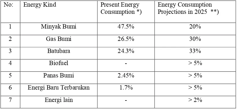
The above three categories are carried out simultaneously and specifically in order to support sustainable development in Indonesia. Legally, the Indonesian government has set a reach out for Energy Elasticity smaller than one in the year 2025. ( Perpres, 2006). The Presidential Regulation Number: 5 The year 2006 also mandating the government of Indonesia to achieve the of energy consumption diversify, called the Energy Mix with the composition of consumption as shown in the Table I.1 below.
Table I.1: The portion of Indonesia Energy Consumption, the Current Energy Consumption and the projected in the year 2025
No: Energy Kind Present Energy
Consumption *) Energy Consumption Projections in 2025 **)
1 Minyak Bumi 47.5% 20%
2 Gas Bumi 26.5% 30%
3 Batubara 24.3% 33%
4 Biofuel - > 5%
5 Panas Bumi 2.45% > 5%
6 Energi Baru Terbarukan 1.7% > 5%
15
*) Sumber: BP Tahun 2008. **) Perpres No5 Th.2006.
Table 1 above showing the sharp descending on the consumption of oil, from 47.5% at present to 20% in the year 2025. On the other side, the table show a sharp ascending on the projected of Gas, Coal and New and Renewable energy consumption.
This dissertation is standing on the attempts to achieve the increment of renewable consumption from 1.7% at present become more than 5% in the year 2025. The mandate of legislations become important from the technical standpoint. We are coming to the time where the sea wave and tidal energy are competitive to conventional thermal generating plants. Its when the fuel cost and the environmental being concerned as remind by Shaw. (Shaw, 1994)
Regarding the waters territory of Indonesia as wide as 2.8 million square kilometers, hydropower became one of Indonesia energy source hope in the near coming years. Hydro energy become the most promising energy when the non-oil, non-CO2 emissions is considered. Hydropower is also considered as secure
alternative energy, compared to nuclear energy. Nuclear energy tend to left behind, realizing the danger of nuclear reactor failure reporting takes many lives in Chernobyl - Russia 1986, Three Miles Island - USA in 1979 and the latest in Fukushima, Japan in 2011 . Hydropower is considered a number of advantages compared with fossil-fueled power plants, among others, do not emit greenhouse gases, uses no fossil fuels, no noise and produces no waste and can be made in small scale. (Fritz, 1984). Hydropower also advantage in operating costs compared with fossil-fueled power plant, its cheaper because water is free in nature. In addition, hydropower has a long service life and does not require a lot of operators for the operation. It is estimated that potential hydropower in Indonesia is 75.000 MW, which is one of the largest hydroelectric reserve in Asia. ( Hayes, 2004; Abdullah, 2005)
16
CHAPTER II
BACKGROUND AND OBJECTIVES
II.1. Background
Indonesia is the worlds largest archipelago state and has the fourth largest population of about 240 million people. Current annual Growth Domestic Product (GDP) growth is between 5% and 6% and it is a net oil importer country, leading in coal and Liquefied Natural Gas (LNG) exporter. In 2008 oil was the dominant energy source with approximately 48% share of the energy mix, coal with 30% and natural gas with 19%. Primary energy consumption was approximately 0.62 TOE/Capita in 2008 and it is growing about 5% per year.( Best, 2011). Indonesia emmitted about 2.1 Gt CO2 equivalent in 2005, which is equivalent to 4.97% of global green house gas
emissions. An increasing from 2.4% of the world emissions or equivalen to 140 million tons of CO2 in 1993 (Petrich, 1993). Most of Indonesian emissions are not
from industrial activity like India, China and Japan but are mainly due to peat fires and deforestation.(Indonesia National Climate Change Commision, 2010; Jupesta, 2011; Brockhaus, 2011).
Indonesia has committed to reduce CO2 emissions as much as 26% until the year
2020. The statement was spoke by the President of Republic Indonesia, Susilo Bambang Yudhoyono on 25 September 2009 in Bangkok at a meeting of leaders of the G-20. The same statement expressed again on the Summit on Climate Change in Copenhagen, Germany on 15 December, 2009 (Reuters, 2009; Environment News, 2009) This commitment will extend to 41% reducing if there is adequate international support.( Jupesta, 2011; Best, 2011). Realizing this commitment is hard to achieve, the government take a number of ways including increasing the investment in Renewable Energy, Reducing the level of 'deforestation' and Review the Draft Land Use.
Indonesia's commitment to reduce CO2 emissions by 26% is certainly hard
17 Research on hydro energy that would do this we consider to support government efforts in the utilization of alternative energy sources that are free of CO2 emissions
and fuel-free to support the government program creates the formation of the Energy Self-sufficient Village (DME) throughout Indonesia proclaimed by the President of Indonesia since 2007 ( State Speech, 2007) as part of efforts to improve the welfare of the people.
II.2. The Urgency of Research
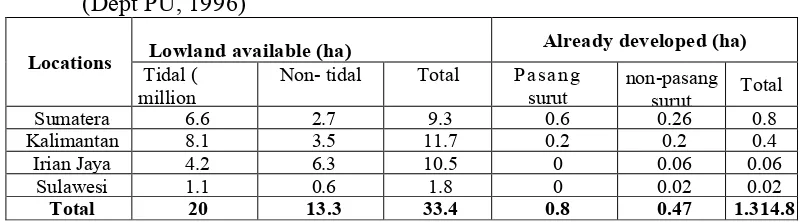
This study will constitute a scientific study which documented and implemented that are ready to be propagated and studied further for similar applications elsewhere. Marsh land area in Indonesia to 2006 is estimated at 33,393,570 hectares consisting of 20,096 hectares (60.2%) tidal land and 13,296 hectares (39.8%) of land of non-tidal marshes (lowlands).
Table II.1. Indonesia lowland distribution and developed area (Dept PU, 1996)
Locations Lowland available (ha) Tidal ( Already developed (ha)
million Non- tidal Total Pasang surut non-pasang surut Total
Sumatera 6.6 2.7 9.3 0.6 0.26 0.8
Kalimantan 8.1 3.5 11.7 0.2 0.2 0.4
Irian Jaya 4.2 6.3 10.5 0 0.06 0.06
Sulawesi 1.1 0.6 1.8 0 0.02 0.02
Total 20 13.3 33.4 0.8 0.47 1.314.8
Out of 0.8 million hectares of already developed lowland in the four major islands in Indonesia, 0.61 million hectares (± 75%) are situated in the region of South Sumatra, which is concentrated in eastern coastal areas of South Sumatra.
Data from the South Sumatra Region VIII (BWSS VIII) is an area of 615,00 hectares in several locations terebar eastern shore of South Sumatra, among others: Telang I, II Telang, Upang Delta, Delta Saleh, Sugihan Left, Right Sugihan, Padang Sugihan, Karang Agung Downstream, Karang Agung Tengah, Hulu Karang Agung, the island Rimau, Air Rengit. Table I.1. The following data show a large irrigation canals at several locations.
Tabel II.2. Tidal irrigation canal in South Sumatera *)
Location Area
Square Primary Canal Secondary Canal Canal length
18
*
) Departemen PU-Direktorat Jenderal Pengairan, 2011.**) Including Saluran Sekunder Pedesaan (SPD) and Saluran Sekunder Drain Utama (SDU)
Primary canals has the following sizes: - Width of canals: 23 meters - Bottom width: 6-8 meters - Depth: 5 meters
Secondary canals has the following size: Top Width : 7 meters Bottom width: 3 meters Depth: 2 meters
19 areas. So with an area of tidal irrigation of 615,250 hectares, the number of secondary canals existed in the area of tidal irrigation in the east coast of South Sumatra are 2136 units.
Suppose, all the secondary canals in South Sumatra can be harnessed to generate electricity through micro hydro drive, then we harvest a considerable mechanical energy that can be extracted from the irrigation canals.
Utilization of water energy in the secondary irrigation canals will related to the efforts of government to create jobs and poverty alleviation. In the state speech in 2007 President of the Republic of Indonesia, Susilo Bambang Yudhoyono explicitly states that "... poverty is not just a man and his household, but also the facilities and the environment ...." Among the programs carried out to realizing the aim is the launched of the Energy Self-sufficient Village (Desa Mandiri Energy) Program throughout Indonesia since 2007.
DME Program in Indonesia was developed with two basic, i.e:
Firstly: non-fuel energy such as micro hydropower, solar energy, wind energy and biogas ;
20 there is a target for additional 4 million ha.(Indonesias Roadmap For Biofuel Developments in 2025; Brockhaus, 2011). These plans are now to be re-evaluated by the strong repulsion from communities and NGO groups, regarding the loss of biodiversity, deforestation, community lands right and orangutan distinction.
The alternative way to get more energy is from renewable energy such as wind energy, water energy, solar energy and biomass. Total hydropower potential of Indonesia is 75.000 MW is one of the largest hydroelectric reserves in Asia. These potential is spreading across 1315 locations with different size and predicted power. A large amount of the capacity could be developed by mini and micro hydropower. A target of 59.5 MW has been set for commercial microhydropower by the end of 2003 and rising to 153.4 MW by 2020. Villages requiring less than 100 kW will be encourage to build off micro hydro where the water resource existed. Micro hydro schemes of 25 kW or larger will be used to replace the diesel-fired plants. (Hayes, 2004) Indonesian government have developed 633 Self Sufficient Energy Village by 2010 out of 2000 villages targeted by 2014. In Indonesia, there are 80,000 villages, which 45% is located on undeveloped areas. 6500 villages out of it are not yet getting electricity. [ Krisnamurthi, 2010)
From the economical point of view, when the water energy in the secondary irrigation canals can be utilized and not reducing the main function of it to irrigate rice fields, the electrical power generated will be a new value added from irrigation canals and economic value for local communities.
Costs incurred by the government to build irrigation systems in Indonesia is very large. Care costs each year to cope with the problem of sedimentation, erosion of the irrigation wall, vegetation that thrives on the edge of the canals and so on, are very large, so it push us to seek the benefits of irrigation canals not only to irrigate the rice fields but also to generate energy to support the daily needs of people in rural areas.
II.3. Research Questions
21 1. Can the flowing water through water control structures be used in a
feasible way to generate mechanical energy without decreasing significantly the function of tidal canal to supply water or drain water from fields?
2. How is in tidal areas the relationship between the energy generated and the daily tide behaviour at the local site ?.
3. How is the relationship between the energy generated and the availability of water related to the season along the year?
4. Is it possible to construct a waterwheel system at the passage with no significant effect to irrigate or drain the fields?
5. How does the energy utilization impacts to the stakeholders in the neighbourhood?
II.4. Hypothesis
The observations in the field and the measurements taken at the site will give a primary data reflecting the behaviour of tidal and the behaviour of flowing water through the passage. From the field data we can analyze and estimate theoritically, how big is the power that could produced by the flowing water through the passage. This power will change from time to time regarding the increment and the decrement of the tide level. From theoritical estimation, we could construct a waterwheel considering some space limitations existing at the passage. Then the power generated could be evaluated and recorded.
The hypotheses of this study are as follows:
The water flowing at the water control structures can be converted into
mechanical energy by using a waterwheel with no significant influence to the main function of irrigation to and/or drainage from the fields.
The power generated is related to the quantity of flowing water.
The aplication of pico hydropower at Desa bangun Sari create impacts on the community..
II.5. Research Objectives
22 low and high tide. The measurements will be taken to the flow of water entering and exiting the water control structures at the wet season and at the dry season. From the measurements, we can clearly find the behaviour of water flowing and its relations to the tide movements and the season. From the measurements we will find the quantity of flow in 24 hours/day, and the speed of flow in 24 hrs/day. From the data taken, we can estimate theoritically how big is the energy contained in the flowing water from time to time.
The detailed objectives of this study are as follows:
Finding the behaviour of water flow at the site and carry out measurements of flow through the water control structures at Desa Bangun Sari – Telang II, Banyuasin;
Analyzing the data and estimating the mechanical power contained in the passage;
Designing a waterwheel by considering the space available in the passage. Recording the shaft horse power generated by the waterwheel at maximum
water level in the wet season and in the dry season;
Analyzing the impacts of pico hydropower on the stakeholders.
23
CHAPTER III
THE FRAME OF THOUGHT
III.1. Literature Review
During the last 800 years watermills have been in operation all over Europe covering the needs of local habitant for mechanical power (Kaldellis,2007). Watermills also have been used since thousands years ago in India, China and Egypt where the energy of water used in daily life for various purposes such as pounding grain, sawing timber and stone, blacksmiths and extracting the metals from the rocks. Waterwheel is the oldest form of equipment converting the water into mechanical energy in the planet. It is not clear since when the water energy was first used in the world, but it is known waterwheel has existed since 2000 years BC. Doomsday Book in 1086 noted the presence of more than 5000 water-powered mill in Britain, there are 60,000 water mills in France in 1820. (Denny, 2004). Recorded in China, India, ancient Egypt, Paraguay, Brazil, Congo and African countries, the energy used for pumping water into the irrigation and irrigated agricultural areas.
In modern life, the people developed some form of equipment of hydropower. Some of them produce mechanical energy, and several others produce electrical energy. Water energy can be harnessed become energy in some manner i.e:
• Dam (Barrages), where the water potentials convert into mechanical energy by the difference in height of water level or called Potential Energy;
• Stream, where the flow energy is converted into mechanical energy through the water flow velocity or called Kinetic Energy;
• Tidal Power, where the devices utilize the water energy might by the difference height or by the stream of tidal water came in and out of a river or canals;
• Wave Power, which are the devices that use waves as a driving source of energy; • Ocean Thermal Energy Conversion (OTEC), which is the power that works by
exploiting the temperature difference between sea surface and the deep water to be useful energy;
24 irrigation canals, where the energy conversion is must not obstruct the rice fields watering, the kinetic energy is the only choice.
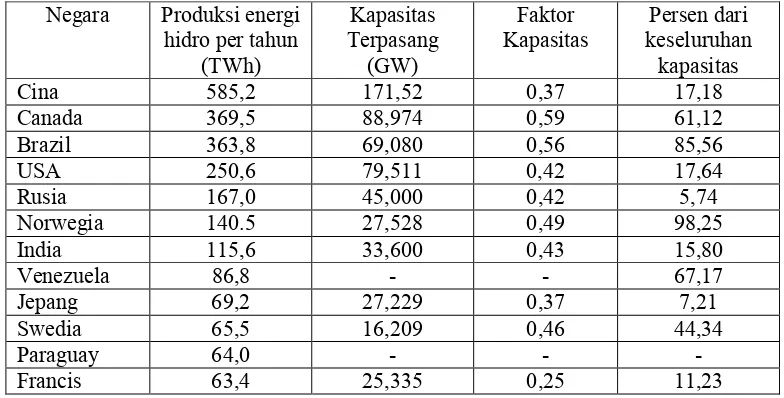
Hydropower currently take accounts for 715,000 MW or 17% of the world's electrical energy. (BP ,2009). Table 1 below is showing the world's energy generation data derived from the energy of water.
Table III.1: The tenth large scale Water Energy Electricity operated in the world by 2009.
Kapasitas keseluruhan Persen dari kapasitas
The amount of power could generated by hydropower is thoroughly depending upon the quantity of flow and the different heights of water level. The greater the quantity of flow and the bigger the difference of water level will the greater the power developed. Based on the availability of water flow quantity and the difference of water level. Quantity of water flow is determined by the magnitude of flow rate, and the difference will determine the altitude of the momentum generated at the blade of water turbine that works based on different heights. Based on the availability of water resources, many types of water turbines have been developed and many different power can be generated.
Hydropower could classified in several classes depending on the power produced. Classification can be seen in the following table:
Table III.2: Hydropower classification based on the power produced
25
1 Large Hydropower > 100 MW
2 Medium Hydropower 15 – 100 MW
3 Mini Hydropower > 100 KW < 1 MW
4 Micro Hydropower > 5 KW < 100 KW
5 Pico Hydropower Up to 5 KW
Source: Practical Answers,2010
http://practicalaction.org/practicalanswers/product_info.php?products_id=41 http://www.reein.org/microhydro/
The classification of hydropower tends to differ from one standard to another. According to the International Hydropower Association (IHA), the rate power of a Small Hydropower Station is usually less than 10 MW, while all stations with rated power less than 1 MW are characterized as mini hydropower. For very small applications, one may also use the expression ‘micro hydropower station’ ( Kaldellis, 2007) Regarding the latest published paper on hydropower there are the same classification for pico hydropower, i.e. up to 5 KW. (Haidar, 2011). On the base of this classification, the title of this study is called Pico Hydropower. This kind of hydropower find the spread attention because of low cost and friendly to environment and potential source of power. Pico hydropower is viewed as a good solution to electrification of the remote sites and small villages in rural areas where the national power-grid system is comparatively uneconomical to extend.
26 the right rachet gear which will transmit the power to the right alternator. This reversion system will possible to apply with minimum impacts to the stream of water when the wheel blade is flat. This concept of power transmission will enable the waterwheel to gain the energy conversion reversibly, no need of installing two waterwheels to gain energy when exiting and when entering the canal.
This study will try to observe and measuring the real phenomenon of tide at the location of studied canal and analyzing the possibility of converting the flowing water into mechanical energy. If theoritically it is possible, the next step is designing the machine by considering the space available in the sluice. The concept is obtaining the energy by utilizing the energy of flow water when entering and when exiting the sluice. This data is evaluated to convince wheter or not the flow of water feasible to convert into mechanical energy.
This is done to ensure a constant supply of energy, where one of the weaknesses of the energy derived from tidal power production is not constant and is not continuous due to the difference in height. To obtain this constant energy in several countries carried the water energy system alloys connection with other energy sources to create constant energy output. but in this dissertation, we try to make the concept of sustainable energy use so that approaches a const ant energy supply and stable. Small scale hydro energy or micro-hydropower has been widely used as a renewable energy resource, especially in areas where scarce energy. For example in areas far from power and out of reach of electricity distribution networks, remote and rural areas. In these conditions, hydropower can be used especially because one of the properties of hydropower that can be mounted on a small river canals or a canals with a continuous flow of water with a relatively small impact on water biota that exist in the canals.
To convert water energy into power can be done using an instrument called a water turbine. Based on how it works, the water turbine can be classified into two categories, namely:
- Reaction Turbine - Impulse Turbine
Both types of turbines are distinguished by the shape of turbine blades, how it convert the water power into energy and the capacity of power generated.
reaction (encased) to accommodate
flow. Most water turbines and reaction turbines are used at low head (<30m/98ft) and medium (30-300m/98
the fixed blade and the moving blade.
Reaction turbines change the velocity of water jet. Jet is hitting the turbine blades that alter the direction of flow thus causing a change momentum (impulse) that give rise to forces on the turbine blades. Before hitting the turbine blades, water pressu (potential energy) is changed into kinetic energy and concentrate it th
to the turbine. Includes the type
Bulb, Tube, Straflo, Tyson, Gorlov, Water Mill, Turbine Archimedes screw. Impulse turbines work on the basis of water flow rate. Energy momentum of the water hitting the turbine blades and turbine wheel. Small impulse turbines require a small amount of water but requires a great height. The type of the impulse turbines are: Pelton, Turgo, Michell
turbine).
III.2.Turbine Selection
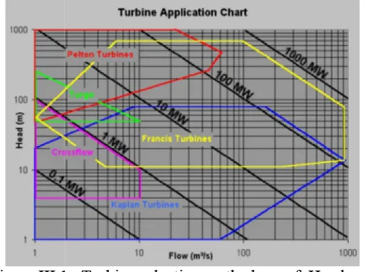
Experience and technical studies have been conducted in various parts of the world have made use of checklists based turbine 'head' and the
available. In general, the selection of the turbine can be done by referring to the chart below.
Figure III.1.
http://www.copperwiki.org/index.php/Mini
reaction (encased) to accommodate the water pressure and fully immersed in water flow. Most water turbines and reaction turbines are used at low head (<30m/98ft) 300m/98-984ft). In a reaction turbine pressure drop occurs in both the fixed blade and the moving blade.
Reaction turbines change the velocity of water jet. Jet is hitting the turbine blades that alter the direction of flow thus causing a change momentum (impulse) that give rise to forces on the turbine blades. Before hitting the turbine blades, water pressu (potential energy) is changed into kinetic energy and concentrate it th
he type of reaction turbines are: Francis, Kaplan, Propeller, Tyson, Gorlov, Water Mill, Turbine Archimedes screw.
Impulse turbines work on the basis of water flow rate. Energy momentum of the water hitting the turbine blades and turbine wheel. Small impulse turbines require a small amount of water but requires a great height. The type of the impulse turbines
elton, Turgo, Michell-Banki (also known as the Crossflow or Ossberger
Experience and technical studies have been conducted in various parts of the world have made use of checklists based turbine 'head' and the volume of flow available. In general, the selection of the turbine can be done by referring to the chart
III.1. Turbine selection on the base of Head and Mass flow. (Wikipedia,2010)
http://en.wikipedia.org/wiki/Water_turbine http://www.copperwiki.org/index.php/Mini-Micro_Hydro_Power
27 the water pressure and fully immersed in water flow. Most water turbines and reaction turbines are used at low head (<30m/98ft) 984ft). In a reaction turbine pressure drop occurs in both
Reaction turbines change the velocity of water jet. Jet is hitting the turbine blades that alter the direction of flow thus causing a change momentum (impulse) that give rise to forces on the turbine blades. Before hitting the turbine blades, water pressure (potential energy) is changed into kinetic energy and concentrate it through a nozzle Kaplan, Propeller, Tyson, Gorlov, Water Mill, Turbine Archimedes screw.
Impulse turbines work on the basis of water flow rate. Energy momentum of the water hitting the turbine blades and turbine wheel. Small impulse turbines require a small amount of water but requires a great height. The type of the impulse turbines
Banki (also known as the Crossflow or Ossberger
Experience and technical studies have been conducted in various parts of the volume of flow available. In general, the selection of the turbine can be done by referring to the chart
ead and
28 Selection of turbines is generally based on the available water head and volume of flow available. In general, impulse turbines are used to place the 'head' is large and reaction turbines are used for a small head. Kaplan turbine is one type of reaction turbine with an adjustable blade that can be used for volume flow and 'head' with a large range of values, where the efficiency remains high
Small turbines with a power below 10 MW can be made with the horizontal axis and for large turbines with power up to 100 MW can pivot vertically .. Francis and Kaplan turbines are generally made of vertical pivot, because the consideration of ease of use head available and make the installation of a generator more economical. While it can be made vertical Pelton turbines horizontal because the smaller engine size of the 'head' is available. Some impulse turbines use multiple water jets (multiple water jets) per-runner to increase specific speed and balance of forces 'thrust' on the shaft
Typically ranging Head for a variety of water turbine
Hydraulic wheel turbine 0.2 < H < 4 (H = head dalam meter) Archimedes' screw turbine 1 < H < 10
Kaplan 2 < H < 40 Francis 10 < H < 350 Pelton 50 < H < 1300 Turgo 50 < H < 250
Michell-Banki 3 < H < 250
(Azad Engineering India, 2010) http://www.copperwiki.org/index.php/Mini-Micro (Wikipedia,2009) http://en.wikipedia.org/wiki/Water_Turbine
(Alpensteel,2010) http://alpensteel.com/article/50-104-energi-sungai-pltmh
Regarding the flow of water that is being the object of study is of low head , theoritically the feasible kind of turbine applied is Hydraulic wheel turbine.
III.3. Waterwheel
29 Generally, hydro-power uses the potential energy of dammed water to drive turbines and generators. The energy generated depends on the volume and the different heights of water in and out. This height difference is called 'head'. The amount of potential energy in water is directly proportional to the 'head'. It is used to concentrate the flow of 'penstock' towards turbine blades.
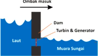
The following figure shows the mechanism of the utilization of tidal energy to the dam to turn turbines and generators
Figure III.2:The water flow into dam when the tide come in (Thicon Gunawan, 2008) http://majarimagazine.com/2008/01/energi-laut-2-pasang-surut
Figure III.3:The water flowing out of dam when ebb (Thicon Gunawan,2008) http://majarimagazine.com/2008/01/energi-laut-2-pasang-surut
Gambar Source: Water power,
Water mill (Waterwheel) is one of
into mechanical energy in a small scale. Based on its position against the flow, the water wheel can be divided into two parts, namely the
Vertical Waterwheel. Vertical axis windmill Wat
in the world, while the horizontal axis water wheel is a type of development that comes after it and most widely u
mills first appeared with Vertical axis made of wo
horizontal axis windmill development after that. Similar windmill better and made of metal starting from the early twentieth century. Water has
efficiency low. Water vertic
performance, a vertical windmill is g
Water turbines horizontal axis has a better performance than the vertical mill, which is approximately 30%. Water turbines horizontal axis can
Based on water jetting position against windmills, water mills horizontal axis can be divided into three kinds, namely:
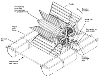
Gambar III.4 : Waterwheel as pump generator.
: Water power, http://www.otherpower.com/otherpower_hydro.html
Water mill (Waterwheel) is one of the devices used to alter the flow of water into mechanical energy in a small scale. Based on its position against the flow, the
ded into two parts, namely the Horizontal Waterwheel . Vertical axis windmill Water is the oldest type of water turbine in the world, while the horizontal axis water wheel is a type of development that comes after it and most widely used until late 20th century. (Monition, 1986). Water mills first appeared with Vertical axis made of wood and called Norse Mill. Water is a horizontal axis windmill development after that. Similar windmill better and made of metal starting from the early twentieth century. Water has a vertical axis windmill efficiency low. Water vertical axis windmill with efficiency of 20% was the best performance, a vertical windmill is generally not more than 15%. (Monition, 1986). Water turbines horizontal axis has a better performance than the vertical mill, which is approximately 30%. Water turbines horizontal axis can be divided into three types. Based on water jetting position against windmills, water mills horizontal axis can be divided into three kinds, namely:
30 http://www.otherpower.com/otherpower_hydro.html
Source: Tidal Power, Cause 2003 Final Project, Pete Clark
htttp://www.ems.psu.edu/~elsworth/courses/cause2003/finalprojects/canutepresentation.pdf
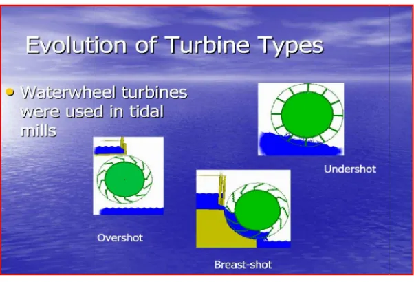
1. Upper flow (overshot), namely the water wheel with a flow of water through the top side.
2. Central Flow (Breast-shot), namely
3. Down stream (undershot), which is below the water wheel with the flow.
Good planning and careful experiments conducted by John Smeaton (1724 1792) shows that the efficiency of the water wheel type F
greater than the horizontal water wheel type with Flow Down (undershot). Middle Windmill Water flow is more efficient than the stream bottom, but less efficient than the flow top. Windmill Water Flow Top benefited from the force
volume of water entering the turbine blade
the kinetic energy comes from water runoff but also from the potential energy derived from the difference in height. Top Flow windmill suitable for use w
'head' of approximately 2 meters. For the 'head' under the mill scale flow is less suitable for use Top, but more suited to the Middle while the Wheel Flow to Head of less than one meter used is the Lower Mill Stream.
The results of research conducted at the Francis by Jean
1867) suggests that two conditions must be met for maximum energy produced. Both these conditions are, first: Water entering the turbine blades should not experience turbulence and the second: Water must be losing spee
turbine blades. With reference to both these requirements then the flow of water Figure III.5: Waterwheel types.
Cause 2003 Final Project, Pete Clark, Rebecca Closner, Lauren Cologe tttp://www.ems.psu.edu/~elsworth/courses/cause2003/finalprojects/canutepresentation.pdf
1. Upper flow (overshot), namely the water wheel with a flow of water through the
shot), namely the water wheel with a central flow (chest) 3. Down stream (undershot), which is below the water wheel with the flow.
Good planning and careful experiments conducted by John Smeaton (1724 1792) shows that the efficiency of the water wheel type Flow Up to 60% or two times greater than the horizontal water wheel type with Flow Down (undershot). Middle Windmill Water flow is more efficient than the stream bottom, but less efficient than the flow top. Windmill Water Flow Top benefited from the force of gravity to the ater entering the turbine blade, so that power is generated not only from the kinetic energy comes from water runoff but also from the potential energy derived from the difference in height. Top Flow windmill suitable for use w
'head' of approximately 2 meters. For the 'head' under the mill scale flow is less suitable for use Top, but more suited to the Middle while the Wheel Flow to Head of less than one meter used is the Lower Mill Stream.
s of research conducted at the Francis by Jean-Victor Poncelet (1788 1867) suggests that two conditions must be met for maximum energy produced. Both these conditions are, first: Water entering the turbine blades should not experience cond: Water must be losing speed he had at the time leaving the turbine blades. With reference to both these requirements then the flow of water
31 ca Closner, Lauren Cologe tttp://www.ems.psu.edu/~elsworth/courses/cause2003/finalprojects/canutepresentation.pdf
1. Upper flow (overshot), namely the water wheel with a flow of water through the
the water wheel with a central flow (chest) 3. Down stream (undershot), which is below the water wheel with the flow.
Good planning and careful experiments conducted by John Smeaton (1724 - low Up to 60% or two times greater than the horizontal water wheel type with Flow Down (undershot). Middle Windmill Water flow is more efficient than the stream bottom, but less efficient than of gravity to the , so that power is generated not only from the kinetic energy comes from water runoff but also from the potential energy derived from the difference in height. Top Flow windmill suitable for use when there is a 'head' of approximately 2 meters. For the 'head' under the mill scale flow is less suitable for use Top, but more suited to the Middle while the Wheel Flow to Head of
32 turbines Bottom (undershot) can reach and have an efficiency of up to 60-70%. ( Monition, 1986) This is the maximum efficiency can be achieved at the Lower Mill Water Flow based on research results.
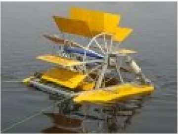
Figure III.6: Waterwheel is used for water aeration.
Figure III.7: Waterwheel as electricity generator.
III.4. Tide and Tide Type
33 these pairs will be enlarged on the strait and the bay area. For example in the UK Bristol Canals, can reach 13 meters.
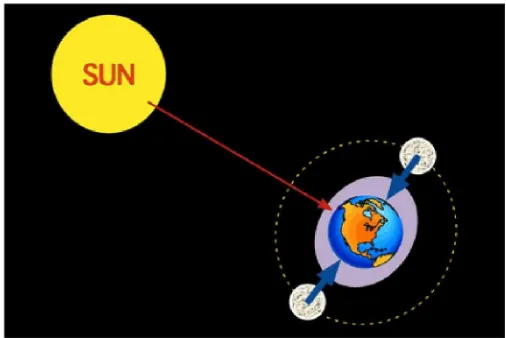
The main cause is the effect of pairs of the Moon, while the effects of the sun is half thereof. Tidal energy generated by relative motion of water that interacts with the force of gravity. Water level changes that occur periodically is related to the gravitational pull of the Moon and the Sun. Magnitude pairs at a location on earth is determined by the change in relative position to the earth moon and sun,
Earth's rotation and the effect of local shape of the seafloor and the coastline .. The second factor that controls the plug on the surface of the earth is the sun's gravity. The average height of the sun's tidal effect is half of the tide due to moon. At one time, because the moon rotates to the earth, then there will be times when the moon, the earth and the sun will be on one line, where the gravitational pull the moon will cooperate with the gravitational force of the sun. At the time it will happen Replace Purnama (Spring Tides), which occurs when the highest tide in the earth's axis is aligned with the Earth-Moon-Sun and the lowest tide on the vertical axis of the earth surface. Put these occurred at new moon and 14-15 days after that.
Time pairs associated with the rotation of the earth and the moon to the earth's rotation. If the moon is a celestial body at rest, then the tide cycle is 24 hours. In fact the moon to the earth rotates about 27 days per cycle, so adding 50 minutes to the tidal period. So long a period of tide is 24 hours 50 minutes.
Because the tide in the earth's surface is a style associated with the interaction of the Sun and the Moon's gravity and Earth's rotation, then the tidal power can not be destroyed or removed, and because of tidal power is categorized as a renewable energy source.
A tidal power plant will utilize this phenomenon to get the water to turn a generator of energy. The greater the tidal ranging, both altitude and speed of tidal currents, the greater the potential energy to generate electricity ..
34 increasing its energy from the Earth-Moon system. Loss of power rotation can only be evaluated in the number of millions of years, so it can be ignored.
There are two forms of the tides, the first Spring Tide (Pasang Purnama). Pasang Purnama occurs when the Moon, Earth and Sun are in a line. This occurred in the early months and on the fourteenth day of the calendar month. At this time the tide is at its lowest and highest positions throughout the year.
Gambar III.8 : Pasang Purnama (Spring Tide)
Source: http://www.physicalgeography.net/fundamentals/8r.html
. Pairs form the second is a Neap Tide (Pasang Perbani), where the position is to attach the sun, earth and moon form a perpendicular angle. At this time, high tide is at its lowest position. This phenomenon occurs on day seven and day 21 of the calendar month
Gambar III.9: Pasang Perbani, occur when the position of Earth, Moon and Sun Form an angel of 90 degrees.
35 The timing of the tides associated with the Earth's rotation and revolution of moon around the earth. If the moon is still room air, tidal cycle will be 24 hours long. But the moon rotates around the earth. Once the rotation takes 27 hours plus 50 minutes of tidal cycles, so the length of the tidal period is 24 hours 50 minutes and 28 second. (Rourke,2009)
There are three types of tides, namely: Attach Diurnal (Diurnal Tide), Place Semi-Diurnal (Semi-diurnal Tide), and Post Mixed (Mixed Tide). These three pairs of different types are determined by the geometric relationship of the Moon and Sun locations on the surface of the earth.
In the Gulf of Mexico and Southeast Asia, is one high tide and one low per day. These pairs are called Post Diurnal (Diurnal tides).
Gambar III.10 : Grafik Pasang Diurnal dalam sehari Source: http://www.physicalgeography.net/fundamentals/8r.html
Semi-Diurnal tide (Semi-diurnal tides) has two levels of altitude and two low-level pairs per day. This phenomenon is usually in the Atlantic Coast of the United States and Europe.
Gambar III.11: Grafik Pasang Semi-Diurnal
36 Many parts of the world experiencing Post Mixed (Mixed Tides) where the turnover of high water and low water is different at each location. In pairs of this type, we find the highest high water and high water sec-also the lowest low water we found the highest and lowest low water. This type of tide is found in the Regulations and the West Coast of the United States.
Figure III.12: The graph of Mix Tide
Source: http://www.physicalgeography.net/fundamentals/8r.html
According to Physical Geography. Net, Southeast Asia has type Diurnal tide, where there is one highest and one lowest tide of each tidal day (calendar month).
Figure III.13: Global distribution of tides on shores on earth, where most of beaches have semi-diurnal type.
37
III.5. Telang II – Banyuasin
Geographically located at the position Banyuasin regency between 1.30 ° - 4.0 ° South Latitude (LS) and 104 ° 00 '- 105 ° 35' East Longitude (BT) which extend from and the central part of South Sumatra Province to the East with a total area of
11,832,99 km2 or 1,183,299 hectares.
Table III.3. Number of People in Villages in the Region Survey Year 2007
No Kelurahan/ Desa Laki-laki Perempuan Jiwa Jumlah Jumlah KK
Source : Monografi Desa Masing-masing Tahun 2008
Table III.4. Average Area per Head of the Family in Villages of Region Year 2007
No Kelurahan Luas Wilayah Jumlah KK Rata-rata
(Km2) Luas (Ha) Per KK
Source : Monografi Desa Masing-masing Tahun 2008
Based on the data area and the number of households in each village / village, it can be estimated average area for each family head. Based on these parameters, it appears that the Village Telangsari, indicate the number / value large enough between the villages of the other, that is 5.3 hectares per family. Meanwhile, with characteristics similar to village Bangunsari and Banyuurip is much smaller, each of the numbers of 1.9 and 1.7 hectares per family.
38 hectare. Transmigration program in accordance with the existing average land ownership society in this area is 2 hectares per head of the Family. Telang II Delta swamp locations where the work performed design review located strategically across the region because it is not too far from the city of Palembang. The distance of about 45 km to the old role of about 1 hours drive and intermediate region between the cities with the port of Tanjung Api-Api. With the location of such a population growth and changes in the area happened so very quickly. As a result of this strategic cross the region has ever built before megalami changes. Information about the picture of the land, the channel network systems and existing buildings in this area is the area of the proposed concept is the basis for further planning
More than 17% of gross domestic product (GDP) was obtained from pertania sector with a growth rate around 3%. Status of food crops in the agricultural sector is very prominent because it is the largest contributor, which is about 62% in 1990. In addition, the agricultural sector is also the largest absorber of labor. Approximately 35.45 also workforce or 72% of the total available labor absorbed by the agricultural sector.
Topography
District Area Banyuasin around 11832.99 km2, lies between 1.3 o - 4o south latitude and 104O 40 ', 105O 15' east longitude. Most of the district is lowland Banyuasin located at the downstream flow of rivers and river Musi Banyuasin. Almost 80% are low-lying areas of tidal marsh and lowlands, while the remaining 20% is dry land with flat to undulating topography and rolling hills with a height of 20-140 meters above sea level. Slope ranges from 0% to a maximum of 2%. Topography measurement results show that the condition of the land area of 5,000 hectares of relatively flat with an average elevation of +6.60 m, the lowest land elevation + 5.90 m and +7.34 m. The highest land Job sites are in rural areas Telang Sari, Sari Mulya, and partly in the Banyu Urip.
Hydrology
39
job sites.
Rainfall data used as the basis for the analysis of rainfall data recorded at Sultan Mahmud Airport rainfall station Badaruddin II, Palembang, with the length of the data for 12 years (Year 1997 to 2008). The results of the analysis show that the maximum annual rainfall of 3542.50 mm, occurred in 2007, while the lowest 2089.50 mm, occurred in 1997. The highest maximum daily rain is 278.30 mm, while the highest average daily rainfall is 9.40 mm throughout the event. The highest monthly average of rain is 344.61 mm, occurred in March, while the lowest was 81.23 mm occurred in August. Climatological data, yielding the value of long sun shines an average of 66.9% varied between 52.4% in January and 80.0% in July. The maximum air temperature was 32.6 ° C and minimum temperature of 22.4 ° C. humidity hádala average annual 83.2% with a range of 80.0% (September) and 85.3% (December). The wind speed varies between 1.6 km / h (November) and 2.7 km / h (January) with an average of 2.1 km / h, and according to Baufort scale, wind speeds classified in the
"weak wind-being".
Projected water deficit is likely to occur in June, July, August and September. Frequency analysis of maximum daily rain to get some extreme daily rainfall values when repeated 5, 10, 25 and 50 years as shown in 170.62; 200.53; 238.33, and 266.37 mm respectively.
Water requirements for crops
Consumptive water requirements for plants are the water requirements for the continuity of life that no other crop is the amount of crop evapotranspiration (ETC). ETC values are influenced by: temperature (air temperature), sunlight, humidity, and wind speed. Crop evapotranspiration can be calculated by the equation:
ETC = kcETo, ... ...(3.1)
40 usually used pan evaporation Class A. The prices of pan evaporation (Epan) converted into the value of ETo to introduce a pan coefficient (Kp) whose value ranges between 0.65 and 0.85 depending on wind speed, relative humidity and elevation, with the following equation:
ETo = Kp. Epan, ... ... (3.2) Nila ETo from Penman evaporation formula on the basis of the reference crop albedo 0.25; so that crop coefficients used to calculate ETo etc, should be based on this with albedo of 0.25 as well. The results according to FAO kc values varied between 0.95 to 1.10, while according Nedeco kc values vary between 1.20 to 1.33. By taking the value of kc at 1.33, then based on ETo values that have been calculated, then the obtained value of ETC consultants calculated monthly as shown in Table 3.1. Based on the results of a calculation of rainfall data collected, the balance between water availability (average monthly rainfall, Rbln) with the water requirements for crops (crop evapotranspiration, etc) can be seen in Table 3.1 and Figure 2.1 below. Water deficit occurred in June, July, August and September, while other months have a surplus. On the basis of this analysis, the cultivation of rice (once a year) can be started in November. If patterned to plant rice 2 times a year, should be planted rice varieties of short-lived (105 days).
Table III.5. Water Balance the between Rain value provided by the water requirements for Plants
Water Quality
Water quality in the tidal swamp area is determined by:
a. Soil properties, especially the depth and state of pyrite, as well as the thickness and
Bulan Rbln ETc bln ∆S Ket
Jan 287.67 182.28 105.39 surplus
Peb 213.59 179.95 33.64 surplus
Maret 344.61 177.82 166.79 surplus
April 308.83 159.92 148.91 surplus
Mei 172.08 161.73 10.36 surplus
Juni 120.23 146.09 -25.86 defisit
Juli 122.31 158.00 -35.70 defisit
Agust 81.23 193.74 -112.51 defisit
Sept 90.60 205.35 -114.75 defisit
Okt 247.85 202.72 45.13 surplus
Nop 320.68 185.88 134.79 surplus
41 state of peat,
b. Drainage and irrigation systems, c. Sluice arrangement, and
d. The frequency of flushing water in the land and channel.
Pyrite is the only substance found on the ground at any tidal area, which formed at the time of land flooded by sea water entering the dry season. At the time of wetlands or stagnant conditions, pyrite is not harmful to plants. However, when exposed to air (oxidized), pyrite transformed into iron and sulfuric acid which can be toxic to plants. Pyrite can be exposed to the air if: raised to the surface of the ground (eg at the time to cultivate the land, making the channel, or create surjan) or when the surface of the ground water falls (eg during the dry season). Thus the system of water management in the tidal swamp land is done by one-way flow system. One channel used as channel revenue tertiary irrigation and drainage channels to be a quarter of tertiary drainage channels. Shallow channel is also required around the mapped fields. These channels serve as a conduit dealer near quarter, irrigation channels and collecting ducts as a quarter near the drainage channel. In the plot of paddy field also made intensive shallow channel which serves to wash the acid substances and toxic substances from the land. Inter-channel spacing varies depending on the constraints of land that can be
set as follows:
a. Land with a pyrite content in the channel created with a distance of 9 m or 12 m, b. Land with pyrite content of shallow channels made with a distance of 6 m or 9 m, c. In acid sulfate land created a channel with a distance of 3 m or 6 m,
d. On land the channel bed is made within 3 m.
Balance that exists between the oxidation and leaching sufficient to maintain the soil becomes sour. It is important to finalize the ground with a low density of immature to implement a system of shallow water settings. To accelerate the maturation process of this type of soil, the soil water during the dry season to be lowered 60 cm below the soil surface. On land that has been cooked quite possible the use of irrigation pumps and tractors combined with the creation of "plow-layer" (immature soils can not maintain a pool of water on the land).
42 agricultural areas to plant rice during the rainy season and planting palawijo on the outside of the rainy time.
Socio-Economic
Location of work is quite close to the city of Palembang, is only + 45 km towards the direction of Tanjung Api-api, and can be reached by four wheel drive vehicles. Private vehicles can go directly to the location, with a smooth asphalt road conditions, so a trip to the location can be reached with a time of 1 hour. Based on the work, the study area includes 8 villages namely administrative Mekarsari Village, Village Bangunsari, Banyuurip Village, Village Muliasari, Village Telangsari, Sukadamai Village, Village and Village Sukatani Muarasugih, all of which belong to the Cape Lago District, District Banyuasin. Banyuasin Regency is a district that has the potential expansion of human resources is quite large in South Sumatra. In mid 2006, the population of District Banyuasin 757.3 thousand inhabitants. While in 2007 there was an increase to Rp 778.6 thousand inhabitants. The increase also occurred in 2008. In mid 2008 the number of conditions.
District population of 790,360 souls Banyuasin. In 2008 also increased the number of residents. In that year recorded a population District Banyuasin in pertangahan year approximately 798,360 inhabitants. The population is large enough it may indicate that there is a potential human resources are quite large.
Equal distribution of the general population may help in efforts to increase prosperity, therefore in the population distribution business ideally in line with the composition of the population of a wide spatial area. In the municipality there are 15 districts Banyuasin in total area is about 11,832.99 Km2, so the average population density in
2007 amounted to 65.80 jiwa/km2. Along with the increase of population, population
density in Banyuasin also increased. In 2006 the population density of 64.01 jiwa/km2, whereas in 2005 amounted to 62.02 jiwa/km2.
43 connected to wide area, in 2008 District Banyuasin still a sparsely populated area, with a population density of 67.47 jiwa/Km2.
Banyuasin diverse livelihoods, but the dominance of the type of work are: industrial / processing, agricultural, and civic buildings. Gross Regional Domestic Product (GDP) is a key indicator in measuring the growth of the economy of a region. Regency GRDP Banyuasin with oil at current prices during the last three years are as follows: in 2006 at 7,029,269 million dollars, in 2007 amounted to 8,158,813 million dollars, and the year 2008 amounted to 9,884,371 million dollars.
Banyuasin economic growth with oil and gas in 2008 reached 5.42 percent. This figure is slower than in 2007 amounted to 6.17 percent. Meanwhile, economic growth Banyuasin without oil and gas grew by 5.78 percent. This value is also slower than in 2007 amounted to 6.53 percent.
The inflation rate by including oil and gas by 14.93 percent in 2008. If inflation is calculated without entering the oil and gas, inflation of 11.03 percent. Income per capita is the Gross Regional Domestic Product (GDP) on the basis of factor cost divided by the population mid-year. Banyuasin per capita income growth rates showed a rise in the period 2006-2008, the Gross Regional Domestic Product Per Capita of Rp. 4,308,229, while the Regional Per Capita Income of Rp. 3,554,289. Associated with design review, socio-economic surveys provide data on the results of the current farming per hectare amounted to Rp. 3.384.00,00 whereas if the project is carried out based on the analysis of income per hectare will be increased to Rp. 8,315,000.00.
Table III.6. Distribution of Land Area
No Village Name Area square (Ha) Area condition
1 Tegal Sari 1787,27 Kelapa planted 48,17 Ha Sawit planted 135,43 Ha Padi planted 1603,40 Ha Luas rata-rata petak tersier 44Ha 2 Mulya Sari 1057,70 Throughout Paddy planted
Luas rata-rata petak tersier 44Ha 3 Banyu Urip 1431,85 Tertanami Padi seluruhnya
Luas rata-rata petak tersier 44Ha
4 Bangun Sari 1431,85 Paddy planted througout Luas rata-rata petak tersier 44Ha 5 Sumber Mekar 785,93 Paddy planted throughout
44
Primary Canal
To illustrate the following visual field survey included photographs in Figure 2.3. while the inventory of available channels 9567.33 m total line length of 5000 Ha area efekktif plan, and these channels can be seen in the following table.
Tabel III.7: Primary Canal
No Nama Saluran Nomenklatur Panjang (m) Jenis Saluran
1 Primer Primer 17.1 477,00 Tanah
2 Primer Primer 17.2 1009,14 Tanah
3 Primer Primer 17.3 246,34 Tanah
4 Primer Primer 17.4 959,59 Tanah
5 Primer Primer 17.5 148,06 Tanah
6 Primer Primer 17.6 950,52 Tanah
7 Primer Primer 17.7 289,12 Tanah
8 Primer Primer 17. 8 925,10 Tanah
9 Primer Primer 17.9 146,97 Tanah
10 Primer Primer 17.10 962,22 Tanah
11 Primer Primer 17.11 216,89 Tanah
12 Primer Primer 17.12 930,51 Tanah
13 Primer Primer 17.13 152,35 Tanah
14 Primer Primer 17.14 953,28 Tanah
15 Primer Primer 17.15 249,39 Tanah
16 Primer Primer 17.16 950,85 Tanah
17 Primer Primer 17.17 894,95 Tanah
18 Primer Primer 17.18 116,08 Tanah
19 Primer Primer 17.19 919.56 Tanah
Sumber : Data hasil pengukuran, 2009
• Secondary Channels
45 conditions, as well as a list of 101,291.81 m along the secondary channel available in Table 2.10 and Figure 2.4.
Figure III.14: Secondary Channel
Figure III.15: Meeting of the Secondary and Primary Channels
Tabel III.8: Secondary Channel
No. Saluran Nomenklatur Panjang (m)
1 Sekunder Utara
SDU 1 Utara 3850,57
SDU 2 Utara 3852,03
SDU 3 Utara 3841,82
SDU 4 Utara 3861,24
SDU 5 Utara 3860,61
SDU 6 Utara 2001,85
SDU 7 Utara 2004,83
SDU 8 Utara 2103,83
SDU 9 Utara 1971.55
2 Sekunder Selatan
SDU 1 Selatan 2037,90
SDU 2 Selatan 2009,95
SDU 3 Selatan 2025,58
SDU 4 Selatan 3854,51
SDU 5 Selatan 3854,10
SDU 6 Selatan 3850,15
SDU 7 Selatan 3801,46
SDU 8 Selatan 3853,46
46
Livelihood and Income Communities.
In connection with the continuation of agricultural development, structuring potential and untapped land use needs to be done. This situation is closely related to the effort that should be encouraged to increase agricultural production due to the development of socio-economic circumstances and cultural societies.
Condition of the Delta Wetlands project area Telang has the potential to be cultivated productive agricultural areas. Generally, residents in the survey area are subsistence farmers have, some other minor work as, entrepreneurs, carpentry, civil servants and services.
As farmers in the agricultural population of activity is by using rain-fed rice, beans, and cucumbers. The last two plants are only planted in the dike, or high ground, around the rice field. Its range is relatively small because it is only a sideline business only., While employers' annual plants (perennials), the main one is oil, then lanseh, durian, rambutan, and coconuts. The plants are grown outside the area of swamp rice fields which is a high land in the vicinity of rice cultivation.
To meet the needs of fat and animal protein, ordinary people catch fish in rivers and channels - channels contained in the survey area. Besides, some people raise cattle, buffaloes, goats, chickens and ducks.
From interviews in mind that the income of the average - average farmer today is about Rp. 19,860,000, - per year. This income is net income from farm crops and have not been reduced by the cost of a day - the day that range between Rp. 35.000, - per day up to Rp. 50.000, - per day. Another farmer incomes, derived from the results of other farm including breeding, which generally reaches 50% of the income of rice farming.