SMARTER THAN YOUR AVERAGE SENSOR: AIS SENSOR THAT INTELLIGENTLY
RE-TRANSMITS MEANINGFUL INFORMATION DERIVED FROM RAW AIS DATA IN
NETWORK LIMITED AREAS
R. G. V. Meyera,b, W. Kleynhansa,b, D. Swanepoela∗
a
Meraka Institute, Centre for Scientific and Industrial Research, Pretoria, South Africa - rmeyer@csir.co.za b
Department of Electrical, Electronic and Computer Engineering, University of Pretoria, South Africa - rmeyer@csir.co.za
KEY WORDS:AIS, Smart Sensor, Spatial Database
ABSTRACT:
AIS is a transponder based, anti-collision system used by the majority of ocean traffic. Ships regularly transmit their identity, position and speed. The information used to populate the AIS fields come from ship based sensors, such as GPS, and user populated fields, such as the vessels name and MMSI number.
These fields are susceptible to spoofing and can be changed to hide the identity or location of a vessel. This is often done to disguise the vessel as a different class to avoid inspections or to enter a protected area without raising alarms.
The AIS system has found great utility in monitoring global shipping trends and traffic but this was never intended when the protocol was designed. Docked vessels still transmit messages regularly that contain no new information. These, and other redundant messages, are still transmitted and stored. In situations where a sensor is remote and has limited access to the Internet this can become costly. The Smart-AIS sensor records all incoming messages locally and makes a decision on whether the message is of special interest or not. Messages of interest are re-transmitted to an external AIS database.
1. MANUSCRIPT 1.1 Introduction
Maritime Domain Awareness can be defined as the knowledge of anything associated with the global or local maritime ronment that could affect the security, safety, economy, or envi-ronment of the area concerned. The goal of MDA is to identify and intercept, or mitigate possible threats before they can signif-icantly impact a country. This would require timely interaction and information-sharing between various stakeholders often sit-uated in different countries or continents. Since most maritime activities are performed by ocean-going vessels, the quick identi-fication of vulnerabilities and threats related to vessels is neces-sary (Tetreault, 2005). Since almost all economic activities car-ried out at sea are performed by vessels it follows that tracking ocean going vessels can be used to monitor maritime activities.
Currently, MDA surveillance is largely performed using vessel transponder data (Eriksen et al., 2006, Tunaley, 2013, Mather et al., 2003, Kleynhans et al., 2013) harbour radar data (Snyman, n.d., Vespe et al., 2008) or satellite SAR imagery (Schwegmann et al., 2015, Kleynhans et al., 2013). Each technology has a its own drawbacks and the best method to obtain a comprehensive view of Ocean activity is by merging the data from multiple sensors (Greidanus and Kourti, 2006).
This paper focuses on information that can be extracted from the data provided by the Automated Identification System (AIS), that is found on most ocean going vessels, and how that information can be transmitted to interested parties in the most cost-effective manner. This is done by decoding and analysing the data on a low cost remote sensor. The on-board analytics allow events (such as vessels changing identity, navigation issues, or entering marine protected areas or ports zones) to be flagged and reported to users.
∗Part of this work was supported by the U.S. Office of Naval Research.
Using a sensor that can receive AIS messages, process them and make decisions on what data is of value the amount of data used to transmit vessel tracking information is reduced while valuable information is highlighted for users.
1.2 Vessel Tracking
Vessels are detected and tracked using either cooperative or non-cooperative monitoring methods. Cooperative methods are de-fined, in this context, as systems where the vessel voluntarily re-ports it’s position and identity. This can be done through radio transponders, network messages or through voice communica-tion. The information provided through these methods is vulner-able to tampering or user error (Balduzzi et al., 2014) and can be switched off to hide vessels completely.
Non-cooperative monitoring systems are technologies that can detect a vessel without the vessel’s compliance. These include coastal radars or optical and SAR imaging. The information con-tained in these methods is usually limited to a vessels position and perhaps size and bearing. Additional methods to classify or iden-tify a vessel from radar or optical images but these are often more expensive and less reliable than cooperative methods (Greidanus and Kourti, 2006).
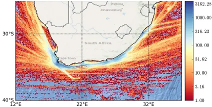
Figure 1 shows a density map for all vessels around South Africa for 2015. This was created using satellite-received AIS data. This image shows that the majority of vessels eventually arrive at the coastline or ports surrounding South Africa. While a coastal re-ceiver would not detect vessels over in the deep ocean a network of receivers would likely detect vessels that pass by or stop at ports.
1.3 User Requirements
Figure 1. AIS reported vessel density around South Africa. Scale is measured in unique vessels per pixel for the 2015 year.
to cover a large geographic region imposes restrictions on what could be used in this project. Other than the obvious requirement of being able to track vessels there are several additional require-ments for the sensor :
• Low unit cost: the lower the price of the sensor the better. A lower cost translates directly into more units and greater geographic coverage.
• Low power requirements: in remote locations the amount of power needed to operate the unit is limited. Low power sensors could be run off renewable power sources.
• Data-processing ability: the sensor would need to demodu-late, process and retransmit multiple messages per second in a continuous stream.
• Low cost of relaying data back to stakeholders: in many re-mote locations using Wi-Fi or Ethernet connections is not possible. More expensive network connections such as cel-lular networks or satellite data providers can then be used but the cost of these would prohibit large data transfers.
• Large monitoring area: using a more sensitive RF front-end and positioning the sensor higher would allow for a larger area to be monitored. The quality of the RF front-end is in direct conflict with the low-cost requirement.
These requirements highlight the trade-off between unit cost and area that can be covered, either by multiple units or a single more powerful unit.
2. AIS PROTOCOL
It is a legal requirement for large ocean-going vessels to carry AIS transponders (International Maritime Organization, 2014). Vessels that fall below the legal threshold of 300 gross-tons often carry AIS transponders due to the utility they provide in avoiding collisions. AIS transponders transmits data over a VHF link in either a single or 2 channels. The carrier frequency used usually limits the reception of messages to line-of-sight. The protocol is open, well documented and there exist multiple libraries to de-modulate and decode the protocol. Given these points, AIS was chosen as the protocol to use when designing a vessel tracking sensor.
The AIS protocol is a self organising, time-domain multiple ac-cess protocol where vessels listen to other vessels in the region, and transmit their messages in open time slots. This can lead
to message collisions when vessels are unaware of other ves-sels transmitting in the same message slot. This is not usually a problem for coastal receivers as they monitor relatively small regions. Satellite based receivers can have a reception footprint many times larger than a coastal station and so experience mes-sage collisions more frequently. The RF frequency and band-width places limitations on the RF front-end that can be used in this sensor design. The details of the AIS protocol is shown in table 1.
Table 1. AIS protocol
Parameter Value Channel A Frequency 161.975 MHz Channel B Frequency 162.025 MHz
Bandwidth 25 KHz
There are many different AIS message types but the information contained can be split into two broad categories: static vessel information and dynamic vessel information. Static information contain fields that are not expected to change very quickly, or at all, and contain:
• Vessel ID (Name, identification numbers, radio callsign etc)
• Vessel class (Tanker, Cargo, Fishing etc)
• Vessel destination (Destination, ETA)
• Vessel physical characteristics (Width, length, position of AIS antenna etc)
Dynamic information changes regularly and may contain:
• Vessel position
• Vessel motion vector (Speed, bearing, rate of turn etc)
• Navigation stats
The static information is usually manually inserted into the AIS transponder and so is vulnerable to user error. Incorrect ID num-bers and names are often seen in AIS data. The dynamic infor-mation is usually obtained from other instrumentation or sensors on board and so is generally more reliable.
3. SENSOR DESIGN AND IMPLEMENTATION Figure 2 shows the basic flow of data through the sensor. The sensor samples the RF spectrum, demodulates the AIS messages, decodes the AIS messages into usable objects and extracts mean-ingful information from the data. The information is then retrans-mitted, through the Internet, to multiple stakeholders.
Figure 2. Basic flow of AIS messages from RF to retransmission.
3.1 Sensor Hardware
It was decided to reduce design time by using off-the-shelf com-ponents for the sensor hardware. This decision would necessitate an RF front-end and a processing component and a transmission component.
There are many software defined radios (SDR) or AIS receivers that can be purchased that would meet the requirements laid out in the previous sections. It was decided to use a RTL-SDR dongle as the RF front-end. This device is cheap, operates in the correct frequency range, and has suitable sensitivity and bandwidth. The SDR operates by tuning to the correct frequency and streaming in-phase (I) and quadrature (Q) components of the sampled radio spectrum to the attached computer. The device is connected via USB. The SDR was originally designed for television reception but has found a large community that uses it for vessel tracking, aircraft tracking, and many other RF applications. The antenna used with the SDR was a mono-pole VHF whip antenna cut to length to operate well at the AIS carrier frequency.
For the processing component a Raspberry Pi 2 Model B sin-gle board computer (SBC) was used. This cheap SBC features a quad-core processor with 1 GB of RAM and several USB ports. This would allow a single core to be dedicated to demodulation while another can be used to decode, filter and retransmit the de-modulated AIS messages.
The location used for the testing of the sensor had Wi-Fi and Eth-ernet access so an additional network adaptor was not required.
3.2 AIS Demodulation and Decoding
The demodulation of the Gaussian minimum-shift keying (GMSK) signal was done in software using GNU-Radio, and open-source signal processing toolkit. TheIandQwere filtered, quadrature demodulated, re-sampled and then interleaved to cre-ate a digital bit-stream of AIS data.
The AIS bit-structure has regular fields that describe different as-pects of the message. The decoded message can be obtained us-ing various look-up tables that transform the bit-field into human readable values.
3.3 Information Extraction
There were approximately 500 000 AIS messages recorded at the Cape Town Harbour each day. The vast majority of those mes-sages had almost no value for users. The mesmes-sages were either repeat messages (received from an AIS repeater) or contained similar information to previous messages from the same vessel.
Figure 3. Flow chart of AIS message filtering and history creation.
Figure 3 is a block diagram describing how the AIS message is filtered. The first step in deciding whether a message is valuable or not is to check whether there is any historical data available for that vessel. Should there not be any vessel-history it is created and contains:
• Last received vessel position vector
• Last received message timestamp
• Last retransmitted position and time
• Vessel position history
• Vessel ID and other static information
Every received message is used to update the vessel-history data. The vessel-history object is also used to decide whether to re-transmit the AIS message to users.
Local geographic maps are also stored that included features such as marine protected areas and port zones. A dynamic heat map of received message is also generated and stored locally. This is used when message from a vessel are no longer received; it deter-mines whether the vessel has stopped transmitting AIS messages or has exited the receivers observable area.
User defined thresholds were used to test each message. These thresholds were simple heuristics to alert of strange vessel be-haviour. These include:
• Vessel speed too high (Speed>25 knots)
• Vessel turning too fast (Course deviation>45 degrees)
• Vessel silent for too long (No message received for 10 min-utes)
• Vessel difference in distance too high (∆Distance>1000 km)
Checking the difference in reported positions can highlight ves-sels that incorrectly share the same ID or a single vessel that falsely reports positions.
Figure 4. Histogram of reported vessel speeds.
3.4 Data Filtering
The were a few possible filters that could be implemented to re-duce the amount of AIS messages being retransmitted while pre-serving the information describing vessel movements.
Figure 4 shows a histogram of reported vessel speeds. This shows that the vast majority of vessels were at rest in the region of inter-est. The vessels in motion were generally travelling between 10 and 15 knots. Figure 5 shows how varying the distance filter of the vessel parameter thresholds reduces the retransmission rate. This sensor was located near a harbour so the messages recorded were mostly from stationary vessels. The implementation of al-most any threshold removed the repeat messages from these ves-sels and greatly reduced the data volume needed to describe their movements.
Figure 5. Messages retransmitted after distance filter implemented.
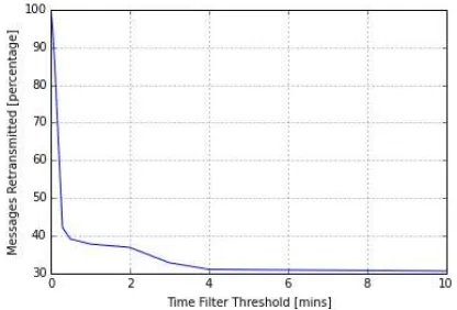
Figure 6 shows the effect that varying the time threshold would have on message retransmissions. The sharp drop when imple-menting the smallest time threshold is due to the same message being received from multiple sources. The location of the AIS sensor was within range of an AIS repeater station. When two AIS messages are compared the difference in time and distance is related to the speed and manoeuvring of the vessel. A ves-sels changing direction transmits AIS position reports more fre-quently. A vessel at rest would transmit the same position each time. Using a combination of time and spacial filters most mes-sages that contain little information can be removed.
Figure 6. Messages retransmitted after distance filter implemented.
The previous few figures show that the bulk of AIS messages oc-cur near, in time and space, to previous messages from the same vessels. Messages from vessels that have no vessel history are always retransmitted.
4. CONCLUSIONS
The AIS sensor described here could assist in highlighting vessel events while reducing the cost of operation of remote AIS sta-tions. The low cost of each sensor would allow multiple sensors to be deployed to monitor a region. The amount of messages that are retransmitted can be throttled based on time and space thresholds. Using strict, but reasonable, thresholds over 80 per-cent of messages can be ignored while still providing adequate vessel tracking. If the user is only interested in anomalous vessel behaviour, such as entering marine protected areas or changing identity, almost all messages can be filtered and only events re-transmitted.
ACKNOWLEDGEMENTS
Acknowledgements of support for the project/paper/author are welcome.
REFERENCES
Balduzzi, M., Pasta, A. and Wilhoit, K., 2014. A security evaluation of AIS automated identification system. In:Proceedings of the 30th Annual Computer Security Applications Conference, ACM, pp. 436–445. Eriksen, T., Høye, G., Narheim, B. and Meland, B. J., 2006. Maritime traffic monitoring using a space-based AIS receiver. Acta Astronautica
58(10), pp. 537–549.
Greidanus, H. and Kourti, N., 2006. Findings of the DECLIMS project: Detection and classification of marine traffic from space.Proc. Advances in SAR Oceanography from Envisat and ERS Missions.
Schwegmann, C. P., Kleynhans, W. and Salmon, B. P., 2015. Manifold adaptation for constant false alarm rate ship detection in South African oceans.IEEE Journal of Selected Topics in Applied Earth Observations and Remote Sensing8(7), pp. 3329–3337.
Snyman, C. N., n.d.Maratime Doctrine for the SA Navy. Director Naval Policy and Doctrine.
Tetreault, B. J., 2005. Use of the automatic identification system (AIS) for maritime domain awareness (MDA). In: Proceedings of OCEANS 2005 MTS/IEEE, IEEE, pp. 1590–1594.
Tunaley, J. K., 2013. Utility of various AIS messages for maritime aware-ness.contract9, pp. 7009458.
Vespe, M., Sciotti, M., Burro, F., Battistello, G. and Sorge, S., 2008. Mar-itime multi-sensor data association based on geographic and navigational knowledge. In:2008 IEEE Radar Conference, IEEE, pp. 1–6.