DEVELOPING AND SELECTING SLOPE STABILIZATION
TECHNIQUES IN MANAGING SLOPE FAILURES
Ari Sandyavitri
Civil Engineering Department, Engineering Faculty, University of Riau Bina Widya Campus, Km 12.5
Simpang Baru Pekanbaru 28293, Riau, Indonesia e-mail : [email protected] and [email protected]
Abstract: This paper objectives are to; (i) identification of risky slopes (within 4 Provinces in Sumatra including Provinces of Riau, West Sumatra, Jambi and South Sumatra encompassing 840 kms of the“Jalan Lintas Sumatra”highway) based on Rockfall Hazard Rating Systems (RHRS) method; (ii) developing alternatives to stabilize slope hazards, and (iii) selecting appropriate slopes stabilization techniques based on both proactive approach and value engineering one. Based on the Rockfall Hazard Rating Systems (RHRS) method, it was identified 109 steep slopes prone to failure within this highway section. Approximately, 15 slopes were identified as potential high-risk slopes (RHRS scores were calculated >200 points). Based on the proactive approach, seven riskiest slopes ware identified. The preferred stabilization alternatives to remedy most of these slopes are suggested as follow; either (i) a combination of retaining wall and drainage, or (ii) gabion structure and drainage. However, different approaches may yield different results, there are at least 2 main consideration in prioritizing slope stabilization; (i) based on the riskiest slopes, and (ii) the least expensive stabilization alternatives.
Key words: rockfall, slopes, rating, risk, hazards
BACKGROUND
Failed slope and rockfall events within “Jalan Lintas Sumatra” highway caused significant hazards for road users, including road accidents, transportation delays, and disruptions. In order to reduce and control the hazards, various slope stabilization techniques are in need to propose in a systematic procedure. In practice, more than hundreds of slopes prone to fail are exist within this highway section, hence a decision support frameworks (based on the geotechnical asset management principle) is needed to take place for effective slope stabilization under budget constraint (Sandhyavitri, 2010).
The Transportation and Public Work Departments within the Provinces in Sumatra Island have historically taken a reactive action in relation to manage steep slope erosions and rockfall hazards rather taken a proactive asset management approach. The reactive action (curative action) has proven to suffer geotechnical asset such as reduction of guardrails effectiveness, blocking of drainage channels, and destroy bridges infrastructures, when erosion/rockfall occurs. This also may damage highway pavement, threat to public facilities and buildings, and potentially hazard to road users. In fact, steep slope erosion and
rockfall events have been regularly occur within the“Lintas Tengah Sumatra”Highway Section (Riau Pos, 2006-2009).
This paper demonstrated a proactive geotechnical asset for management of rockfall hazards in order to address issues of highway safety in a systematic procedure, while at the same time making optimum use of limited budget resources based on best value for money.
LITERATURE REVIEW
vehicles. A numerical score in RHRS represents potential risk hazards. Various measures (including geologic character, slope height, ditch effectiveness, and vehicle exposure) were used in calculating the risk hazard. This research utilized RHRS version from the Oregon Department of Transportation (ODOT). (Pierson and Vickle, 1993, and Brett, 2005).
ROCKFALL HAZARD RATING
SYSTEM (RHRS) ODOT
The Oregon’s rockfall hazard rating system was
developed to assess hazard rating to potentially hazardous rockfall/erosion sites around the state of Oregon, in order to prioritize remedy slopes as budget constraint. Rockfall hazard rating systems (RHRS) was established to replace a conventional reactive action in managing steep slope erosion and rockfall (Pierson and Vickle, 1993, and Lynn, 2000). Two major steps for identification and investigation of slopes are drawn below: (Pierson and Vickle, 1993; Sandhyavitri, 2008 and 2009).
Preliminary Survey
The purpose of this preliminary survey is to gather specific information on where slope/rockfall sites are located, estimating initial slope/rockfall hazard ratings, and to estimate to what extent of the rockfall problem may impose hazards to road users. Often, the (Angkutan Kota Angkutan Propinsi/ bus travel) who pass the highway regularly. The historic perspective provided by the local community, bus drivers, and persons who maintain the slopes are as an important element of the slope hazard preliminary ratings. Past rockfall activities are good indicators of what to expect in the future.
The RHRS objective is to identify the rockfall potential along a highway site. Rating may
classify as "A", “B” and “C”. Initially only the
"A" rated sections should be advanced for further evaluation and investigation with the detailed rating system (see Detailed Rating below). This will economize the survey effort, while making sure that only those, the most critical areas are investigated. The "B" rated sections should be evaluated as time and funding available. The "C" rated sections will receive no further investigation.
Detailed rating
The purpose of the detailed rating is to score in numerically differentiate the relative risk hazard at the identified sites along 837 kms highway section in Sumatra Island. Once they are rated, the slopes can be sorted and prioritized based on their scores.
Based on RHRS, 1993 various parameters are established to identify slope hazards, they are encompassing 12 parameters (Pierson and Vickle, 1993, and Sandhyavitri, 2009): 1) Slope height; the vertical height is measured from the heel of a slope, up to its highest point. This height may range from 25 ft to > 100 ft. 2) Ditch; is dependent on how well the ditch is performing in capturing rockfall. This cover area within road shoulder including drainage. It is classified as; Good (i.e. erosion and rockfall materials are captured in the ditch area) to limited (fallen materials spread up to cover roadway). 3) Average vehicle risks (AVR); is associated with the percentage of time a vehicle to be involved in a rockfall event (in 25%, 50%, 75%, and 100% ). The percentage is obtained by using the formula (1). 4)Percent Decision sights distance (DSD); is the distance of highway required by a driver to perceive a problem and to react stopping a vehicle. Sight distance itself is defined as the shortest distance that a six-inch object is continuously visible by a driver. DSD was numerically scored as; 40% (very limited sight distance) up to 100% (adequate sight distance).Formula (2)
ADT (cars/day) x Slope Length (miles) / 24 (hours/day) x 100% = AVR (1) Posted Speed Limit (miles hour)
5)Highway width; is measured as width of highway pavement from one side to another side of highway section. The measurement represents the available space for driver to maneuver avoiding rockfall. 6) Geological character; this consists of a series of relatively horizontal basalt flows. This is classified into two cases (with encompasses four parameters): a) is for dominant rockfall events to occur at slopes where joints, bedding planes, or other discontinuities are present. b) is for slopes where differential slope erosion is the dominant condition to occur. 7) Block Size/Volume; volume of fallen material at the ditch or road pavement (in ft3). 8) Climate and Presence of Water on Slope; the effects of precipitation and water flowing on the slope are grouped according to 4 categories (category 1. low to moderate, precipitation and no water on slope, up to category 4. High precipitation or continual water on slope) 9) Historical rockfall activity at a site; is as an indicator of future rockfall events. This may range from; few falls (3 point), Occasional falls (9 point), few falls (27 point), and Constant falls (27 point).
In general, RHRS established four simple approaches in scaling the scores (i.e. 3, 9, 27, and 81) (Pierson and Vickle, 1993). The higher the RHRS scores the higher their potential risk hazard would become. As consequences, the more prioritized they are to remedy (Sandhyavitri, 2009, Pierson and Vickle, 1993, and Youssef, 2003).
Managing Rockfall Hazard Costs
Based on the asset management standpoint, the key words in rockfall hazard management are
highway users’ safety, cost effectiveness, and
reliability of control measures (Brett, 2005). Various approaches haven been taken to manage the geotechnical asset, this paper investigated two approaches i.e., proactive approach and value engineering approach (Rockfall Mitigation Cost Estimate, RMCE).
Proactive Approach develops an approach by a systematically identification slopes prone to rockfall/erosion, data inventory, prioritizing the identified slopes to remedy, and taking action to remedy.
This approach may assist process decision in managing geotechnical asset to become more efficient and economical use of resources, as well as improved safety and increased confidence of the highway users (Pierson et al., 1990 and Sandhyavitri, Ari, 2009). This approach prioritization leads to remedy of the worst sites first. Remedy is typically focused on the hazard mitigation and risk reduction techniques.
A value engineering approach (Rockfall Mitigation Cost Estimate, RMCE) incorporates a risk-based framework and economies point of view (Pierson et al., 1990). Value engineering suggests in reduction of hazard factors to an acceptable level while minimizing risk by remedying slopes. This approach considers a balance between slope stabilization costs and its risk hazard (Pierson et al., 1990 and Sandhyavitri, Ari, 2009).
According to RMCE, a cost estimate is an important element to put into consideration when final project priorities are established. The rockfall design cost calculated is strictly the stabilization cost for the identified slopes above. RMCE costs may be defined as:
RMCE = Cost /RHRS Score Ratio (3)
The main advantage for the implementation RMCE is a reduction in the management of rockfall/erosion potential. Only those potential rockfall/erosion slopes are taken into consideration to remedy.
Design Criteria to Remedy Slopes
Various design option criteria may remedy slope prone to rockfall/erosion have been identified (Pierson and Vickle, 1993, Sandhyavitri, 2009, and Brett T. Rose, 2005). These may dependent on the type of geological slopes, length of slopes, slope heights, rockfall/erosion history, and types of design criteria.
slope screening, catch fence, drainage, and shotcrete.
RESULT OF THE PRELIMINARY
SURVEY
Intensive preliminary survey has been carried out during May-June 2009 encompassing a 837 Km of highway section passing 4 provinces in Sumatra Island, with the starting point is from Pekanbaru City (Riau) - Taluk Kuantan (Riau)
– Kiliran Jao (Riau) –Dharmasraya (West Sumatra) - Muaro Bungo (Jambi) - Sarolangun (Jambi) – Lubuk Linggau (South Sumatra) –
Tebing Tinggi (South Sumatra) – up to Lahat
(South Sumatra) (Picture 1). This “Lintas
Tengah”highway section is as the main access to connect Southern part of Sumatra Island to Northern one. This is considered as the busiest highway in Sumatra compared to other alternative roadways (Lintas Timur and Lintas Barat Sumatra).
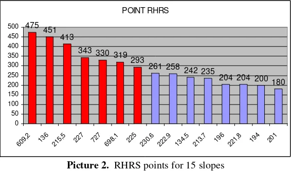
Various steep slopes were investigated. Most of steep slopes are concentrated in the Middle part and Western part of Sumatra Island, stretching from North to South area with altitude of 100-1000 m (Picture 2) covers 837 kms of "Lintas Tengah Sumatra" highway (Picture 1). The investigated slopes are classified as rocky slopes, semi rock and soil, and soil slopes. The average slopes heights are at the range of 8 m to 40 m.
The investigated slope areas were located stretching from Muara Lembu, Singigi District, Taluk Kuantan Regency,
Riau Province (with coordinate of 00 22 15.1 S; 101 20 42.2 E) up to Suka rame-rame village, Lahat Regency, South Sumatra province (03 45 47.6 S; 103 28 03.8 E). The average rainfall within this area at the range of 101-300 mm (10-20 in) and is classified as medium rainfall zone.
DATA ANALYSIS
This survey identified 109 slopes with 15 slopes ware considered as potential to fall/erosion. Their location area as follow: 1)Highway section at Pekanbaru – Taluk Kuantan (Riau) : 2 slopes. 2) Highway section at Taluk Kuantan (Riau)- Kiliran Jao (West Sumatra) : 5 slopes. 3) Highway section at Kiliran Jao (West Sumatra)–Muaro Bungo (Jambi) : 4 slopes. 4) Highway section at Sarolangun (Jambi)- Lahat (South Sumatra) : 5 slopes.
These risky slopes were then further investigated to calculate their RHRS scores (based on 12 parameters above. It was summarized that there are 2 main groups of slopes; (1) Very high risk hazard
encompassing KM 136; KM 215,5; KM 227; KM 609,2; KM 698,1; KM 727 and KM 225; and (2) high risk hazard slopes; KM 134,5 (left) ; KM 196; KM 213,7; KM 221,8; KM 2292,9; and KM 230,6. Very high-risk hazard slopes consider to have RHRS score of >275 points, and high-risk one less than 275 but no less than 180 (Picture 2 and Table 1).
Picture 2. RHRS points for 15 slopes
Table 1.Rockfall Hazard Rating Systems (RHRS) 7 slopes at Highway Pekanbaru–Lahat
NO KM RHRS
POINT Description
1 609,2 475 Height: 8 m (26.25 ft), ditch: No catchments, vehicle: 5000 unit per day, Per-centage of sigh distance= 93.73%, road width, 5.5 m (18.04 ft), Major diffe-rential erosion features, Extreme difference, High precipitation and Constant falls. Slope is a typical soil slope with relative less vegetation covers it sur-face.
2 136 451 Height: 8 m (26,25 ft), ditch: No catchments, vehicle: 3000 unit per day, Per-centage of sigh distance= 50%, road width, 6 m (19.68 ft), Major differential erosion features, Extreme difference, low precipitation or no water on slope, and few falls. Slope is a typical soil slope with relative less vegetation covers it surface.
3 215,5 413 Height: 17 m( 56 ft), ditch: limited catchments, vehicle: 3000 unit per day, Percentage of sigh distance= 80%, road width, 6 m (20 ft), Major differential erosion features, Extreme difference, High precipitation, and many falls 4 227 343 Height: 16 m (52.5 ft), ditch: limited catchments, vehicle: 5000 unit per day,
Percentage of sigh distance= 63%, road width, 7 m (23.6 ft), Discontinuous joints, random orientation, clay filling, and Constant falls
5 727 330 Height: 7.5 m(25 ft), ditch: good catchments, vehicle: 5000 unit per day, Per-centage of sigh distance= 80%, road width, 5.8 m (19 ft), Major differential erosion features, Extreme difference, High precipitation, and occasional falls 6 698.1 319 Height: 8 m(26.25 ft), ditch: limited catchments, vehicle: 5000 unit per day,
Percentage of sigh distance= 100%, road width, 6 m (19.68 ft), few differen-tial erosion features, small difference, moderate precipitation or continual water on slope, and few falls
7 225 293 Height: 8 m (26.25 ft), ditch: No catchments, vehicle: 5000 unit per day, Per-centage of sigh distance= 93.73%, road width, 5,5 m (18.04 ft), minor diffe-rential erosion features, minor difference, moderate precipitation, and regular falls
1. Slopes with RHRS points >275 (Very high Risk hazard) 2. Slopes with RHRS points >200-275 (high Risk hazard) 3. Total surveyed slopes were 109 zones.
POINT RHRS
475 451
413
343 330 319 293
261 258 242 235
204 204 200180
0 50 100 150 200 250 300 350 400 450 500
609,
2
136
215,
5
227 727
698.
1
225
230.
6
222.
9
134.
5
213.
7
196
221,
8
Picture 2 and Table 1 show the relative significance of slope hazards to remedy based on the RHRS scores. The higher RHRS scores the higher the slopes to prioritize for remedy.
For example, the slope at KM 609.2 (with RHRS 475 points) was considered as the worst slope condition compared to 109 the other ones. The slope conditions were as follow; however the slope height was relatively short 8 m (26.25 ft), but there was no catchments area to cover rockfall/erosion at the slop toe, the slope also constitutes major differential erosion features, and extreme difference of erosion features, with the slope surface was also exposure to climate condition (less vegetation to cover it surface to reduce erosion) and it was reported that the slope was constantly falls; hence based on these conditions this slope was perceived as potential to risk public users passing the slope. Furthermore, the average vehicle numbers was relatively dense (5000 unit per day) and percentage of sigh distance was very high (93.73%), with road width was relative narrow
(limited to 5.5 m or 18.04 ft). This slope was considered as potential, where rockfall/erosion remedy was urgently needed.
Alternative Techniques to Remedy Slope Hazards
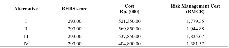
Various design techniques were developed to remedy a certain slope. This paper demonstrates design techniques to remedy slope at KM 225 (RHRS 293) for example. This slope height: 8 m (26.25 ft), no catchments to collect falling materials, road width, 5.5 m (18.04 ft), minor differential erosion features and regular falls. Slope is a typical combination of soil rock slope and a 100 m of slope was in need to remedy. Firstly, the slope needs to scale to normalize its gradient (into three levels). Then, define 3 remedy alternatives, such as: Alternative 1. Combination of retaining wall and drainage; Alternative 2. Combination of Short Crete and drainage; Alternative 3. Combination of Slope screening and drainage; and Alternative 4. Combination of Catch fence and drainage.
Table 2. Risk Management Cost at KM 225
Alternative RHRS score Cost
Rp. (000)
Risk Management Cost (RMCE)
I 293.00 521,350.00 1,779.35
II 293.00 569,850.00 1,944.88
III 293.00 537,850.00 1,835.67
IV 293.00 404,800.00 1,381.57
(Source: Research Documentation, 2009)
Cost Estimate
Cost estimate for scaling (soil rock slope) was calculated approximately Rp.171.000/m3, retaining wall was Rp. 3,085,000/m (Dimension = Trapezium: floor =0.70 m, head= 0.30, height= 4.00 m), constructing of shortcrete was Rp. 304,500/m2, slope screening was Rp.231,000/m2, catch fences was Rp. 269,000/m2, and drainage was Rp. 279,000/m (Dimension; wide= 0.5 m, height= 0.5 m, and thickness= 0.1) (Source: Research Documentation, 2009).
Then, the cost combination of slope remedy to each single alternative was calculated, and divided by RHRS score, and the results were tabulated as Risk Management Cost (Table 2).
The smallest Risk Cost was Alternative IV (combination of catch fences and drainage), and followed by Alternative I (combination of retaining wall and drainage). These structural combination to remedy slope at KM 225, were
then process together with the other slopes’
remedy techniques and was tabulated (Table 3).
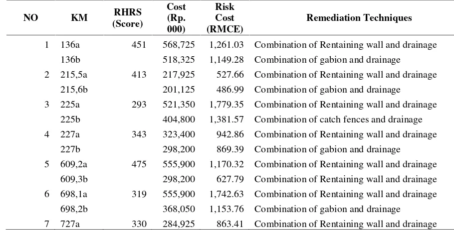
Rockfall Mitigation Cost Estimate Analysis for 7 Slopes
This paper simulated seven riskiest slopes to consider remedying using combination of (i) catch fences structure and drainage, (ii) retaining wall and drainage, and (iii) gabion structure and drainage. The smallest Risk Cost
of the slope, the more likely it is to consider to remedy.
The results finding from Table 6 shows that there is a trend on highly RHRS slope scores, may contribute to lower Risk Management Cost (RMCE) values, as the RMCE is equal to value of cost estimate for remedy slope, divided by RHRS score.
Based on Table 1 and Table 5 results, it was drawn a recommendation scheme which slopes are prioritized to remedy based on Proactive (RHRS) approach and Value Engineering (RMCE) one.
Based on Table 4 and Pictures 5 and 6, seven potential slopes prone to erosion/rockfall were identified, there was significant shifts in priori-tizing which slopes are in need to remedy. Proactive approach (RHRS) arranges slopes as the following order; KM 609.2, KM 136, KM 215.5, KM 227, KM 727, KM 698 and KM 225.
Table 3.RHRS scores versus Risk Cost (RMCE)
NO KM RHRS
(Score)
Cost (Rp. 000)
Risk Cost (RMCE)
Remediation Techniques
1 136a 451 568,725 1,261.03 Combination of Rentaining wall and drainage 136b 518,325 1,149.28 Combination of gabion and drainage
2 215,5a 413 217,925 527.66 Combination of Rentaining wall and drainage 215,6b 201,125 486.99 Combination of gabion and drainage
3 225a 293 521,350 1,779.35 Combination of Rentaining wall and drainage 225b 404,800 1,381.57 Combination of catch fences and drainage 4 227a 343 323,400 942.86 Combination of Rentaining wall and drainage
227b 298,200 869.39 Combination of gabion and drainage
5 609,2a 475 555,900 1,170.32 Combination of Rentaining wall and drainage 609,3b 298,200 627.79 Combination of Rentaining wall and drainage 6 698,1a 319 555,900 1,742.63 Combination of Rentaining wall and drainage
698,2b 368,050 1,153.76 Combination of gabion and drainage
7 727a 330 284,925 863.41 Combination of Rentaining wall and drainage
Table 4.Head to head RHRS and RMCE approaches
Proactive Approach (RHRS) Value Engineering Approach (RMCE)
KM POINTS RHRS Slope KM RMCE Keterangan
609,2 475 soil rock 215,5 486.99 combination gabion and drainage 136 451 soil rock 609,3 627.79 combination gabion and drainage 215,5 413 soil rock 727 787.05 combination gabion and drainage 227 343 soil rock 227 869.39 combination gabion and drainage 727 330 soil rock 136 1149.28 combination gabion and drainage 698,1 319 soil rock 698,2 1153.76 combination gabion and drainage
225 293 Rock 225 1381.57 combination catch fences and drainage
Pictures 5 and 6.The prioritized slopes to remedy based on RHRS and RMCEapproaches
Biaya resiko
0 200 400 600 800 1000 1200 1400 1600
215,5 609,3 727 227 136 698.2 225
KM
b
ia
y
a
r
e
s
ik
o
RHRS
0 50 100 150 200 250 300 350 400 450 500
609,2 136 215,5 227 727 698,1 225
KM
R
H
R
S
p
o
i
n
t
Risk cost
CONCLUSIONS
It was identified 109 steep slopes prone to erosion and rockfall events across highway section in four provinces in Sumatra Island, Indonesia.
Approximately, 15 slopes were identified as potential high-risk slopes (high RHRS scores), such as; the slopes at Km 609.2 (RHRS score of 475), KM 136 (RHRS 451) and KM 215.5 (RHRS 413).
Twelve factors contribute to RHRS scores were also identified (e.g.; slope heights, ditches, highway width, average vehicle risks (AVR), block sizes, and rockfall history).
Based on the proactive approach (RHRS), the
higher its’ scores, the more prioritized they are
to remedy. On the other hand, based on the value engineering approach (RMCE), the smaller Risk Management Cost values (of the slopes), the more they are in need to remedy. The RMCE values was identified as following order; KM 215.5 (486.99), KM 609.3 (627.79) and KM 727 (787.05) respectively.
The RMCE puts into account the technical and economic aspects of slope conditions for managing rockfall hazard in order to address issues of highway safety in a systematic procedure as well as efficient in use of limited budgets.
ACKNOWLEDGEMENT
The author would like to express gratitude to
the “Hibah Kompensi, HIKOM, 2010” Project,
under the Directorate of Higher Education of Indonesia, supporting me to do this research study, and I also would like to extend thanks to
Ibnu Satria, and Suriyetno for his contributions in assisting in the field survey and developing this paper.
REFERENCES
Ari Sandhyavitri, 2008, Sistem Pengambilan Keputusan Perbaikan dan Pemeliharaan Lereng Berdasarkan Prosedur Manajemen Aset, Prosiding Seminar Hasil Penelitian Dosen Jurusan Teknik Sipil, ISBN 987 979 792 135 5, Unri Press, Mai 2008.
Ari Sandhyavitri, 2009, Investigasi Tingkat Kerawanan Lereng Bagi Pengguna Jalan di Ruas Jalan Pekanbaru-Bukittinggi Ber-dasarkan Metode RHRS, Prosiding FSTPT XII, Surabaya 13-14 Nopember 2009. Brett T. Rose, 2005, Tennessee Rockfall
Man-agement System, PhD Dissertation, The faculty of Virginia Polytechnic Institute and State University, USA.
Budetta P, 2004, Assessment of rockfall risk along roads, http://www.nat-hazards- earth-syst-sci.net/4/71/2004/nhess-4-71-2004.pdf,USA.
Lynn Kathy, 2000, “Landslide”, Oregon De-partment of Land Conservation & Devel-opment, Salem, USA in http://www.oregon.gov/LCD/HAZ/docs Pierson A. Lawrence, Vickle Robert Van, 1993,
Rockfall Hazard Rating System Partici-pant's Manual, NHI Course No.130220, Publication No. MA SA-93-05, Federal Highway Administration, USA.
Riau Pos Koran tahun 2004-2009 tentang kelongsoran tebing di Jalan Lintas Riau-Sumatra Barat-Jambi-Riau-Sumatra Selatan. Youssef, A., Maerz, N. H., and, Fritz, M.