Report on Sanitary Shoreline Survey within the Tanbi Wetlands
National Park and Other Shellfish Harvesting Communities,
The Gambia
By: Gambia-Senegal Sustainable Fisheries Project (USAID/Ba Nafaa)
June, 2012
A partnership of:
United States Agency for International Development / West Africa Coastal Resources Center, University of Rhode Island
And The Gambia Government
2
This publication is available electronically on the Coastal Resources Center’s website at http://www.crc.uri.edu. For more information contact: Coastal Resources Center, University of Rhode Island, Narragansett Bay Campus, South Ferry Road, Narragansett, Rhode Island 02882, USA. Tel: 401) 874-6224; Fax: 401) 789-4670; Email: [email protected]
Citation: USAID/Ba Nafaa project (2012). Sanitary Shoreline Survey within the Tanbi Wetlands National Park and Other Shellfish Harvesting Communities. Gambia-Senegal Sustainable Fisheries Project and the Coastal Resources Center, University of Rhode Island, pp.38
Disclaimer: This report was made possible by the generous support of the American people through the United States Agency for International Development (USAID). The contents are the responsibility of the authors and do not necessarily reflect the views of USAID or the United States Government. Cooperative Agreement # 624-A-00-09-00033-00.
Cover Photos : Oyster harvesting site in Mandinary (Left); Fish/Oyster landing site in Jeshwang (Center); Processing oyster in Kubuneh (Right photo).
3
Table of Contents
1. Background ... 6
1.1 Importance of Sanitary Control of Shellfish ... 6
1.2 The Gambian National Shellfish Sanitation Programme (GNSSP) ... 6
1.3 Objectives of the Gambian National Shellfish Sanitation Programme ... 6
1.4 Sanitary Shoreline Survey ... 7
2. Introduction ... 8
2.1 Description of the Tanbi Wetlands National Park (TNWP) ... 8
2.2 Other Shellfish Growing and Harvesting Communities ... 9
2.3 Organizations Involved in Sanitary Shoreline Survey ... 9
3. Methodology used in the Sanitary Shoreline Survey ... 10
4. Results of Sanitary Shoreline Survey ... 10
4.1 WENCHO (Code 001) ... 11
4.2 KAMALO (Code 002) ... 13
4.3 OLD JESHWANG (Code 003) ... 15
4.4 EBO TOWN (Code 004) ... 16
4.5 FAJI KUNDA (Code 005) ... 18
4.6 ABUKO (Code 006)... 20
4.7 LAMIN LODGE (Code 007) ... 22
4.8 DARANKA/KEREWAN (Code 008/009)... 24
Annex I: Shoreline Shellfish Sanitary Survey. Tanbi Wetlands Reserve. ... 37
4
List of Figures
Figure 2. 1: Satellite image of The Tanbi Wetlands area ... 8
Figure 4 (a), (b), (c): Locations of survey sites... 10
Figure 4. 1 (a): Dumping of litter in the intertidal zone ... 11
Figure 4. 1 (b): Human settlement at the intertidal zone ... 11
Figure 4. 1 (c): Waste in the intertidal zone... 11
Figure 4. 1 (d): Settlement near the intertidal zone ... 11
Figure 4. 1 (e):One of the nine pig pens near the intertidal zone ... 12
Figure 4. 1 (f): Drainage channel emptying into the river from nearby facility ... 12
Figure 4.2 (a): Heaps of groundnut shell and a rubbish dumping site ... 13
Figure 4.2 (b):Resting tent between heaps of groundnut shells ... 13
Figure 4.2 (c):Potentially contaminated stream flowing into mangroves ... 13
Figure 4.2 (d):Heaps of ground nut shells obstructing stream water flowing ... 13
Figure 4.2 (e): Fecal and Total Coliforms for Kamalo site. ... 14
Figure 4.3 (a): A pig pen located in the inter-tidal zone ... 15
Figure 4.3 (b): Trash scattered over the inter-tidal zone ... 15
Figure 4.3 (c): A woman fish processor (fish smoker) waiting for fishermen ... 15
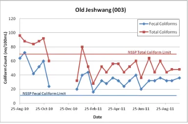
Figure 4.3 (d): Fecal and Total Coliforms for Old Jeshhwang site. ... 16
Figure 4.4 (a): A young man from swimming in the stream ... 17
Figure 4.4 (b): Trash and human settlement near the intertidal zone ... 17
Figure 4.4 (c): An open grave yard approximately 100 meters from the intertidal zone ... 17
Figure 4.4 (d): Fecal and Total Coliforms for Ebo Town site. ... 18
Figure 4.5 (a): Indiscriminate dumping site close to the mangroves ... 19
Figure 4.5 (b): A dumping site ... 19
Figure 4.5 (c): Settlements and rubbish dumping site along the storm runoff path... 19
Figure 4.5 (d): Fecal and Total Coliforms for Faji Kunda site. ... 20
Figure 4.6 (a): Settlements near the intertidal zone ... 21
Figure 4.6 (b): Fishing boats anchored near the mangroves ... 21
Figure 4.6 (c): Fecal and Total Coliforms for Abuko site. ... 21
Figure 4.7 (a): Drain pipes from Lamin Lodge toilets emptying directly into the estuary ... 22
Figure 4.7 (b): An outside toilet which empties directly into the estuary... 22
Figure 4.7 (c): Boats used for excursions by the tourists ... 22
Figure 4.7 (d): Drain pipe from the outside toilet emptying into the estuary ... 22
Figure 4.7 (e): Fecal and Total Coliforms for Lamin Lodge site ... 23
Figure 4.8 (a): Mangrove swamps at Daranka/Kerewan site ... 24
Figure 4.8 (b): An old fishing boat at the site ... 24
Figure 4.8 (c): Fecal and Total Coliforms for Daranka site. ... 24
Figure 4.8 (d): Fecal and Total Coliforms for Kerewan site... 25
Figure 4.9 (a): Lodge/Guest House is located few meters from the shoreline ... 26
Figure 4.9 (b): Show grounds at the edge of the intertidal zone ... 26
Figure 4.9 (c): Shoreline survey team members measuring salinity ... 26
Figure 4.9 (d): Fecal and Total Coliforms for Mandinari site. ... 26
Figure 4.10 (a): Erosion of the water way leading to the estuary ... 27
Figure 4.10 (b): Women oyster harvesters grading oysters into different sizes ... 27
Figure 4.10 (c): Rubbish heap near the intertidal zone ... 27
Figure 4.10 (d): Fecal and Total Coliforms for Kubuneh site. ... 27
Figure 4.11 (a): Oyster processing site ... 28
Figure 4.11 (b): Heap of unprocessed oysters ... 28
5
Figure 4.12 (a): Children helping in oyster processing... 29
Figure 4.12 (b): Oyster processing tools and materials ... 29
Figure 4.12 (c): Dump site near the intertidal zone ... 30
Figure 4.12 (d): Site used for recreational and cultural activities ... 30
Figure 4.12 (e): Fecal and Total Coliforms for Bafuloto site. ... 30
Figure 4.13 (a): Oyster processing site ... 31
Figure 4.13 (b): Oyster processing site ... 31
Figure 4.13 (c): Mangrove swamp at a low tide ... 31
Figure 4.13 (d): Fecal and Total Coliforms for Mandinaba site. ... 31
Figure 4.14 (a): Boat landing and restaurant on the coast ... 32
Figure 4.14 (b): Drain pipe from restaurant’s toilet discharging directly into the stream ... 32
Figure 4.14 (c): Trash burning site near the stream ... 32
Figure 4.14 (d): Bar area/bantaba located further from the water ... 32
6 1. BACKGROUND
1.1 Importance of Sanitary Control of Shellfish
Emphasis is placed on the sanitary control of shellfish because of the direct relationship between pollution of shellfish growing areas and the transmission of diseases to humans. Shellfish borne infectious diseases are generally transmitted via a faecal-oral route. The pathway is complex and quite circuitous. The cycle usually begins with faecal contamination of the shellfish growing waters. Sources of such contamination are many and varied.
Contamination reaches the waterways via runoff, dumping and direct discharges. Clams, oysters and mussels pump large quantities of water through their bodies during the normal feeding process. During this process the shellfish also concentrate microorganisms, which may include pathogenic microbes, and toxic heavy metals and synthetic organic contaminants. To reduce the human health risk of consuming shellfish from contaminated areas, it is imperative that shellfish growing areas are free from pollution and the hygienic and sanitary conditions of the environments are improved.
1.2 The Gambian National Shellfish Sanitation Programme (GNSSP)
Production, harvest, shipment and sales of uncooked molluscan shellfish in all of the shellfish-producing states and in foreign countries, that conduct sales in the United States markets, are governed by the National Shellfish Sanitation Programme (NSSP) (ISSC, 2009). Therefore, The Gambia must conform to the regulations of the Program if it wishes to expand the markets and potentially export the shellfish regionally in West Africa and to the United States and Europe. NSSP requires conducting periodical shoreline surveys to identify potential sources of contaminants which form the basis for the water quality classification. The area of focus of this study is the West Coast Region (WCR) of The Gambia.
The Gambian National Shellfish Sanitation Programme (GNSSP) is conducted in accordance with the guidelines set by the Interstate Shellfish Sanitation Conference (ISSC) contained in the National Shellfish Sanitation Programme (NSSP) Guide for The Control of Molluscan Shellfish Model Ordinance contained within the NSSP Guide (ISSC , 2009)
1.3 Objectives of the Gambian National Shellfish Sanitation Programme
The objectives of National Shellfish Sanitation Programme is based on biological, ecological, social and economic issues. These same objectives are contained in the Cockle and Oyster Fishery Co-management Plan.
Biological Objective:
7 Ecological Objective:
• Maintain the health and functioning of the mangrove ecology, thereby protecting important habitats of oysters and other shellfish, finfish, and marine mammals including the West African manatee.
Social Objective:
• Strengthen Community Participation in planning, implementation and decision making in the rational and sustainable use and management of the oyster and cockle resources.
Economic Objective:
• Access to improved markets, financing, and poverty reduction among oyster harvesters.
1.4 Sanitary Shoreline Survey
To accurately assess waters for shellfish harvesting, an evaluation of the pollution sources that are likely to affect the area is required by the NSSP. The shoreline survey is conducted of the shellfish growing area shoreline and estuary to locate pollution sources that could have an effect on the water quality of the area. The report should analyze and summarize survey data which includes:
• Shoreline survey of sources of environmental pollution • Hydrographic and meteorological data
• Bacteriological survey of growing waters
8 2. INTRODUCTION
2.1 Description of the Tanbi Wetlands National Park (TNWP)
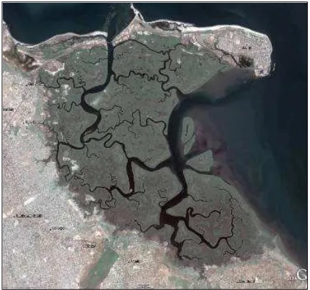
The central coordinates of the Tanbi Wetlands National Park (TWNP) are 13°26’ North and 16°38’ West. TWNP has an area of 6,304 hectares. TWNP is a mangrove swamp that fronts the Atlantic Ocean to the north and the Gambia River to the east. It is located at the mouth of the River Gambia, occupying the southern portion of the estuary (see Figure 2.1 below). It has developed through the combination of deposition of fluvial and marine sediments. It is an estuarine and intertidal forested wetland primarily of low mangrove forest, with a complex of vegetation types on its northern boundary and along the mangroves fringing the mainland. The TWNP functions include coastal stabilization, fish breeding and oyster and cockle production, and recreation.
Figure 2. 1: Satellite image of The Tanbi Wetlands area
Humans settled around this area for five centuries. The area is bordered by twelve villages. The Greater Banjul human settlement surrounds TWNP to the south and east. Mandinary, Lamin and Abuko towns are bordering TWNP to the south; to the west, Fajikunda, Talinding, Ebotown and Jeshwang towns limit TWNP. Banjul is at the north-eastern border while Bakau town is to the north-west of TWNP. The area includes some part of the Banjul City area, some parts of Kanifing Municipality and some areas of the Brikama Area Council.
The communities living around TWNP are diverse; one could notice two types of population: one not dependent on TWNP resources and the other directly or indirectly is relying on the wetland resources. For the later, rice cultivation, vegetable growing, oyster and cockle collection by women, shrimp fishing and mangrove cutting by the men for fuelwood and construction purposes are the main activities in the buffer zone and within the wetlands. Tourism is developed around Lamin and Denton Bridge where the surrounding communities gain some employment but they receive few other benefits from it.
9
family units within their respective communities. Prior to 2007, there has been no form of organization and no formal rules legitimized via Government except the annual closure during the rainy season, and there were no formalized committees for managing conflicts or determining rules.
The Tanbi Wetlands National Park was designated as a RAMSAR site on World Wetlands Day in 2007. The Government of The Gambia decided that the 6,304 hectare mangrove system was important due to its high biodiversity and diverse and rare ecosystems with valuable marine resources. It is important to keep the ecosystem healthy, promote sustainable livelihoods and not use destructive means of harvesting the resources.
2.2 Other Shellfish Growing and Harvesting Communities
There are five other shellfish growing communities outside the Tanbi Wetlands National Park. These communities are also included in the National Sanitary Shoreline Survey and TWNP, oyster harvesting, processing and marketing are important economic activities which generate income for the women and their families.
2.3 Organizations Involved in Sanitary Shoreline Survey
The USAID funded Ba-Nafaa Project is funding the bi-monthly water quality and bi-annual shoreline surveys within TWNP and other shellfish growing areas in the West Coast Region. The Water Quality Laboratory of the Department of Water Resources has been monitoring the water quality in these areas since August, 2010.
10
3. METHODOLOGY USED IN THE SANITARY SHORELINE SURVEY
A trained team comprising staff of Government Departments, Public Agencies and USAID/ BaNafaa WASH Program conducted sanitary shoreline survey in the oyster harvesting sites under TRY Oyster Women Association. A total of 15 shellfish growing and harvesting areas, number coded consistent with the codes used in the water quality monitoring, were covered.
A hand-held GPS receiver was used to obtain the coordinates of the sites. Detailed field notes were taken and locations of the sites were determined by examination of Google Earth images. As part of the records, digital photographs of potential contaminate sources were taken and images from Google Earth were employed to supplement documented sources of contamination. Salinity measurements were recorded using a portable refractometer. A form (See Annex I) was used to record the data during the survey.
The collected data was populated in sanitary shoreline survey database. 4. RESULTS OF SANITARY SHORELINE SURVEY
During the initial survey which was conducted during the months of January and February 2012, fifteen oyster harvesting sites were visited (see Figure 4). The findings and descriptions of sites are discussed in this section. Corresponding water quality monitoring data collected by the Department of Water Resources between August 2010 and September 2011 are also included.
Figure 4 (a), (b), (c): Locations of survey sites.
11 4.1 WENCHO (Code 001)
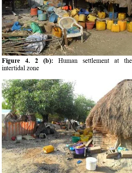
In Wencho (Code 001), the population of the settlement is approximately 120 individuals, comprising five families. The community is mainly engaged in oyster harvesting, fishing and subsistence agriculture. There are no toilets and sanitary facilities and the community is predominantly exposed to open defecation. The rubbish is indiscriminately dumped in the settlement. There are several poultry houses and nine pig pens located in the intertidal zone. A small drainage outlet is located in the settlement that collects effluent from the nearby stores and pig pens and drains into the river. Another drainage channel collects and directs rainwater to the river from the nearby storage facilities. There is no potable water supply present and the residents get water from either the stores, Royal Victoria Teaching Hospital (RVTH) Sanatorium or from the National Water and Electricity Company (NAWEC) water tanks opposite Mile Two central prison. The photographs taken at this site are shown in Figure 4.1.
Figure 4. 1 (a): Dumping of litter in the
intertidal zone Figure 4. 2 (b): intertidal zone Human settlement at the
Figure 4. 3 (c): Waste in the intertidal zone Figure 4. 4 (d): Settlement near the intertidal
12
Figure 4. 5 (e):One of the nine pig pens near the
intertidal zone Figure 4. 6 (f):the river from nearby facility Drainage channel emptying into
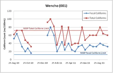
Figure 4.1 (g) shows that measured Fecal Coliforms at this site are above the established NSSP Fecal Coliform limit (14 MPN/100mL). Total Coliforms also exceeded the limit for Total Coliforms (70 MPN/100mL) set by NSSP.
13 4.2 KAMALO (Code 002)
Heaps of groundnut shells present on the side of the wetland. A rubbish heap is obstructing the stream water flow and contributing to the contamination of the aquatic environment. There are no toilets and sanitary facilities available and the place has an illegal waste dumping site. At the time of the survey, there was no oyster harvesting activity taking place
Figure 4.2 (a): Heaps of groundnut shell and a
rubbish dumping site Figure 4.2 (b): groundnut shells Resting tent between heaps of
Figure 4.2 (c): Potentially contaminated stream
14
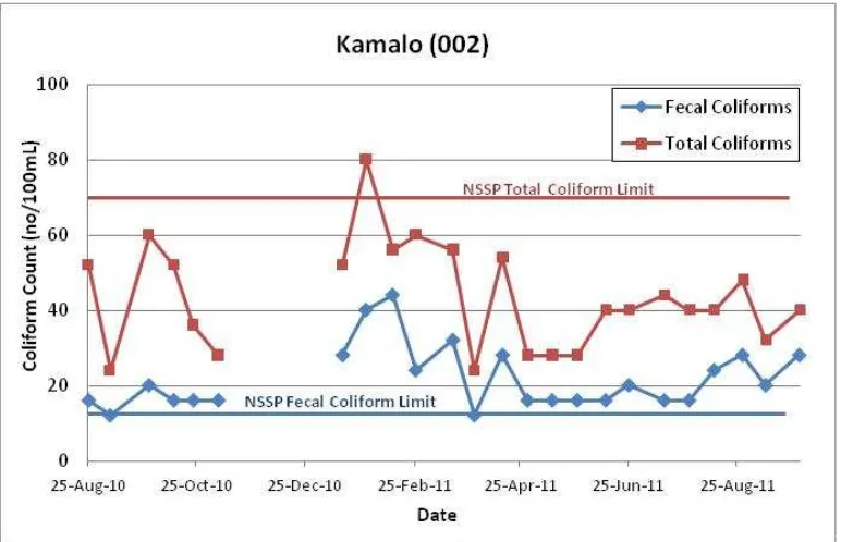
Figure 4.2 (e) shows that measured Fecal Coliforms at this site are above the NSSP limit. Total Coliforms exceeded the limit for Total Coliforms set by NSSP only once during the data collection period.
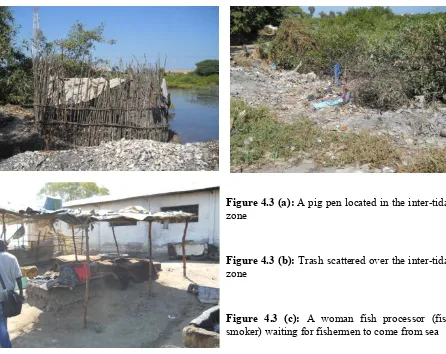
15 4.3 OLD JESHWANG (Code 003)
There are no toilets and sanitary facilities available at the landing site. As can be seen from Figure 4.3 (a), there is a pig pen located at the intertidal zone. At the time of the survey, there was no oyster harvesting activity. The site is used for dumping of human and other wastes and trash scattered over the place as shown in Figure 4.3 (b). A woman fish smoker was resting (Figure 4.3 (c)) and waiting for the arrival of fishermen from the sea. The fact that fisheries activities are happening at the landing without a specified dumping and sanitary facilities are a cause for concern.
Figure 4.3 (a): A pig pen located in the inter-tidal
zone
Figure 4.3 (b): Trash scattered over the inter-tidal
zone
Figure 4.3 (c): A woman fish processor (fish
smoker) waiting for fishermen to come from sea
16
17
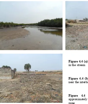
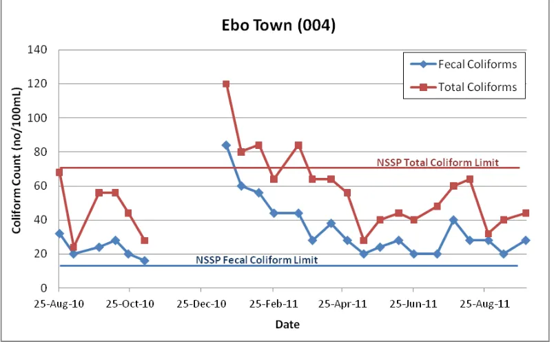
4.4 EBO TOWN (Code 004)
The site is used for recreational (swimming) activities mainly during the dry season. There are human settlements not far from the intertidal zone. The waste dump is nearby and an open grave yard (not fenced) is located about 100 meters from the intertidal zone. Animals were seen loitering in the immediate vicinity and fishermen were repairing and mending their fishing nets. Like at the previous sites, there are no toilets and sanitary facilities available.
Figure 4.4 (a): A young man from swimming
in the stream
Figure 4.4 (b): Trash and human settlement
near the intertidal zone
Figure 4.4 (c): An open grave yard
approximately 100 meters from the intertidal zone
18
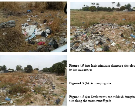
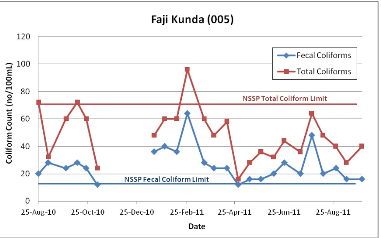
19 4.5 FAJI KUNDA (Code 005)
There are no toilets and sanitary facilities available at the site. The team observed indiscriminate dumping of wastes and non-biodegradable substances near the intertidal zone as can be seen in Figure 4.5.
Figure 4.5 (a): Indiscriminate dumping site close
to the mangroves
Figure 4.5 (b): A dumping site
Figure 4.5 (c): Settlements and rubbish dumping
site along the storm runoff path
20
21 4.6 ABUKO (Code 006)
There are no toilets and sanitary facilities at the landing site, which is a major sanitary concern. Also, the fact that human settlements are not far from the intertidal zone, fishing and its related activities taking place at the site and the absence of a designated dumping site are all potential sources of pollution (see Figure 4.6).
Figure 4.6 (a): Settlements near the intertidal
zone Figure 4.6 (b): mangroves Fishing boats anchored near the
Figure 4.6 (c) shows that measured Fecal Coliforms at this site are above the NSSP limit. Total Coliforms exceeded the limit for Total Coliforms set by NSSP during data collection in September 2010.
22 4.7 LAMIN LODGE (Code 007)
Lamin Lodge is located at the intertidal zone and it is a very important tourist centre. It is one of the sites within TWNP that has toilet facilities. However, the toilets are located in the intertidal zone near the fish landing site and un-treated human waste is directly emptied into the river through drainage pipes from Lamin Lodge itself. Waste dumps, tourist boats and fishing/oyster harvesting boats are present at the site (see Figure 4.7).
Figure 4.7 (a): Drain pipes from Lamin Lodge
toilets emptying directly into the estuary Figure 4.7 (b): directly into the estuaryAn outside toilet which empties
Figure 4.7 (c): Boats used for excursions by the
tourists Figure 4.7 (d): emptying into the estuaryDrain pipe from the outside toilet
23
24 4.8 DARANKA/KEREWAN (Code 008/009)
Daranka and Kerewan oyster landing site is jointly shared by both communities. The landing site is far from the communities and also lacks toilet and sanitary facilities. Figure 4.8 (a) shows the mangroves of Daranka/Kerewan site and Figure 4.8 (b) shows an old fishing boat. At the time of the survey, there were no fishing and oyster harvesting activities present.
Figure 4.8(a): Mangrove swamps at
Daranka/Kerewan site Figure 4.8 (b): An old fishing boat at the site
Figures 4.8 (c) and (d) show that measured Fecal Coliforms at this site are on the lower side but still above the NSSP limit. For both, Daranka and Kerewan, sites Total Coliform count is below the limit for Total Coliforms set by NSSP.
25
26 4.9 MANDINARI (Code 010)
There is a lodge/guest house and a show ground that is very close to the shoreline (see Figure 4.9). No toilets and sanitary facilities available. There were no oyster and fishing activities during the survey.
Figure 4.9 (a): Lodge/Guest House is located few
meters from the shoreline
Figure 4.9 (b): Show grounds at the edge of the
intertidal zone
Figure 4.9 (c): Shoreline survey team members
measuring salinity
Figure 4.9 (d) shows that measured Fecal Coliforms at this site are near the NSSP limit and Total Coliform count is below the limit for Total Coliforms set by NSSP.
27 4.10 KUBUNEH (Code 011)
There are no water and sanitary facilities provided at the site. Moderate erosion as a consequence of storm water runoff into the mangroves is shown in Figure 4.10 (a). The women oyster harvesters were found processing and grading oysters into the different sizes (see Figure 4.10 (b)). The site is also used for washing of animals, boat landing, drying of mangrove logs and orchards are located not far from the estuary.
Figure 4.10 (a): Erosion of the water way leading to
the estuary
Figure 4.10 (b): Women oyster harvesters grading
oysters into different sizes
Figure 4.10 (c): Rubbish heap near the intertidal
zone
Figure 4.10 (d) shows that measured Fecal Coliforms at this site are below the NSSP limit (most measurements) and Total Coliform count is below the limit for Total Coliforms set by NSSP. The water quality monitoring results shows that the sanitation conditions at this site are nearly acceptable.
Figure 4.10 (d): Fecal and
28 4.11 BAFULOTO (Code 012)
The Oyster harvesting and processing site is located approximately one kilometre from the village settlements. The processing of oysters is done close to the intertidal zone (Figures 4.11 (a) and (b)). There are horticultural and other related farming activities carried out near the estuary (Figure 4.11 (c)). Toilets and sanitary facilities are not available.
Figure 4.11 (a): Oyster processing site
Figure 4.11 (b): Heap of unprocessed oysters
Figure 4.11 (c): Agricultural fields near the
estuary
29
Figure 4.11 (d): Fecal and Total Coliforms for Bafuloto site.
4.12 KEMBUJEH (Code 013)
The oyster harvesting and processing site is about one kilometre from the village and there are no toilets and sanitary facilities. Oyster processing activities were done by children and their mothers during the survey (Figures 4.12 (a) and (b)). About 50 meters upstream from the processing site is an area that is frequently used for recreational and cultural activities during the summer (Figure 4.12 (d)).
Figure 4.12 (a): Children helping in oyster
30
Figure 4.12 (c): Dump site near the intertidal
zone Figure 4.12 (d): cultural activities Site used for recreational and
Figure 4.12 (e) shows that measured Fecal Coliforms at this site are on the lower side but still above the NSSP limit. However, Total Coliforms have not exceeded the limit for Total Coliforms set by NSSP.
31 4.13 MANDINABA (Code 014)
The Oyster harvesting and processing site is located approximately one kilometre from the village settlements. The processing of oysters is done close to the intertidal zone (Figure 4.13). There are horticultural and other related farming activities carried out near the estuary. Toilets and sanitary facilities are not available.
Figure 4.13 (a): Oyster processing site
Figure 4.13 (b): Oyster processing site
Figure 4.13 (c): Mangrove swamp at a low tide
Figure 4.13 (d) shows that measured Fecal Coliforms at this site are on the lower side but still above the NSSP limit. However, Total Coliforms have not exceeded the limit for Total Coliforms set by NSSP.
32 4.14 KARTONG (Code 015)
The oyster processing/boat landing site is located approximately 2.5 kilometers from the Kartong village. There are two bars and restaurants and one of them has toilet facilities, but the effluent drain pipe leads to the estuary. Sanitary facilities for oyster harvesters and fishermen are not available. Water supply is not available and water used for fisheries and other related activities is brought from the village. The site is rarely used for recreational swimming purposes due to strong currents (Figure 4.14).
Figure 4.14 (a): Boat landing and restaurant on
the coast Figure 4.14 (b): toilet discharging directly into the stream Drain pipe from restaurant’s
Figure 4.14 (c): Trash burning site near the
33
Figure 4.14 (e) shows that measured Fecal Coliforms at this site are below the NSSP limit during most of the data collection period. Total Coliforms have not exceeded the limit for Total Coliforms set by NSSP.
34 6. CONCLUSION AND RECOMMENDATIONS
The shoreline survey team visited 15 oyster growing and harvesting communities around Tanbi Wetlands National Park and other oyster harvesting communities in West Coast Region as part of Gambian National Shellfish Sanitation Programme (GNSSP). Collected data and observations show that shoreline sanitary conditions are not satisfactory and the areas are in the need of major sanitary improvements.
It is evident that only Lamin Lodge (Code 007) and Kartong (Code 015) have sanitary facilities with water seal toilets, but these facilities are designed to discharge directly into the adjacent waterways. The rest of the oyster harvesting and processing sites lack any facilities. The sites also do not have water supply and water is usually carried from the nearby villages and/or compounds.
Some sites, especially next to urban settlements have indiscriminate waste dumping next to the estuary. Pig pens located in or near the intertidal zone pollute the water and are the cause of observed elevated coliform bacterial counts in adjacent waters. The water quality data show that the oyster harvesting areas near urban settlements have larger numbers of fecal (FC) and total coliforms (TC) in the water than the sites that are located further from the villages. However it should be noted that in many of the oyster producing sites, water quality based on coliform counts is frequently below the 70 TC/100mL standard of the U.S. NSSP, albeit less frequently below the 14 FC/100 mL standard. These relatively low coliform counts may be explained by the relatively low human population densities in areas directly adjacent to the estuary, and as a result of the lack of the widespread use of urban sewage disposal systems with central collection sewerage and discharge into the waterway. Most toilet facilities in Gambia, when they exist, consist of upland pit latrines that allow for collection, retention and some soil treatment of human fecal wastes, thus minimizing likelihood of contaminants reaching the river or estuary (as discussed by Rice et al., 2012). These findings suggest that attention to improvements to sanitary toilet systems in the upland that focus on technologies for the collection, retention, composting and recycling of fecal wastes may be a highly effective means to achieve goals of public health, but sanitation of shellfish-producing waterways as well.
To improve the sanitary conditions of the oyster harvesting sites and comply with NSSP the following is recommended:
• Further develop the Gambian NSSP
− Develop specific tasks required for Gambian NSSP − Develop G-NSSP standard operating procedures
− Develop MOU that specify responsibility for each agency (Department of Fisheries, Department of Water Resources, Department of Health, National Environment Agency, Department of Parks and Wildlife Management, Department of Forestry, Governor of WCR, Brikama Area Council, Kanifing Municipal Council, Banjul City Council)
− Develop funding mechanisms for interagency cooperation in developing and implementing the GNSSP
35
• Identify and remediate the known fecal contamination
− Define and map out shellfish growing waters and identify problem areas − Work with public health authorities in the development of programs to
promote the adoption of composting/recycling toilet systems to not only promote public health and shellfish sanitation, but conserve freshwater supplies as well.
− Establish a working group of all interested stakeholders to address the sanitary problems:
• To construct the water and sanitary facilities at each site
• To clean the waste along the shoreline and establish waste management programmes in these communities
• Sensitize the surrounding communities on waste management and best sanitary practices and conduct regular training on Participatory Health and Sanitation Transformation (PHAST)
• Create buffer zones along the intertidal zones to prevent human settlements
• Implementing water quality and sanitary shoreline surveys
− Conduct baseline surveys and record results in spreadsheet − Conduct regular bi-annual sanitary shoreline surveys − Conduct regular bi-monthly water quality monitoring
36 REFERENCES
Rice M.A. and Kanyi B. (2011) Results of Preliminary Shoreline Shellfish Sanitary Survey near Banjul, The Gambia conducted on 18 June 2011.
Rice M.A., Konteh F., Drammeh O., Nichols E., and Kanyi B. (2012) Preliminary Report on Sanitary Water Quality, Shellfisheries and Aquaculture of Crassostrea tulipa in the Tanbi Estuary of Gambia, West Africa. Journal of Shellfish Research 31(1):225-226.
37
Annex I: Shoreline Shellfish Sanitary Survey. Tanbi Wetlands Reserve.
Date: _______________________________
Shoreline Shellfish Sanitary Survey: Tanbi Wetlands Reserve
38 Toilet Facilities (circle one): Yes No
Comments:
Annex II: Information/data collected during the survey.
Table 1. Information/data collected during the survey.
Code Site Date Time of
008/009 Daraka/Kerewan 2/2/2012 13:30 No 13˚23'2.8" 16˚37'20.7" 14
010 Mandinaring 2/2/2012 14:03 No 13˚23'1" 16˚36'10.7" 35