CAFET-INNOVA Technical Society
-
Helping Scientific Community1-2-18/103, Mohini Mansion, Gagan Mahal Road, Domalguda, Hyderabad-500 029, A. P., INDIA Website: www.cafetinnova.org, Contact #: +91-7411311091, Email: [email protected]
Editor-in-Chief:
Dr. D. VENKAT REDDY
Professor, NIT-Karnataka, INDIA President - CITS
Executive Editors:
Dr. T. N. SINGH
Professor, IIT-Bombay, INDIA
Dr. PAVANAGURU
Professor, Osmania Uni., INDIA
Dr. P R REDDY
Scientist (Retd.), NGRI, Hyd., INDIA
Editor:
Dr. RAJU AEDLA
Founder&Secretary General-CITS
Technical Editors:
Dr. Paul M. Santi Colorado School of Mines, USA Dr. Choonam Sunwoo Director, KIGSMS, SOUTH KOREA Dr. Hsin-Yu Shan
NCT University, TAIWAN Dr. Ganesh R. Joshi University of the Rykyus, JAPAN Dr. Krishna R. Reddy University of Illinois, Chicago, USA Dr. S. Neelamani
Kuwait Inst of Sci Resrch, KUWAIT Dr. Joanna Maria Dulinska Cracow Uni. of Tech., POLAND Dr. Shuichi TORII Kumamoto University, JAPAN Dr. S. Viswanathan IIT-Bombay,Powai, Mumbai, INDIA Dr. K. Uma Maheshwar Rao IIT-Kharagpur, West Bengal, INDIA Dr. Subhasish Das
IIT-Kharagpur, West Bengal, INDIA Dr. Kalachand Sain Scientist EII, NGRI Ltd, INDIA Dr. S. M. Ramasamy Vice-Chancellor, GR Univ, INDIA Dr. C. Natarajan
NIT-Tiruchirapalli, INDIA Dr. Katta Venkataramana NIT-Karnataka, Surathkal, INDIA Dr. M. K. Nagaraj
NIT-Karnataka, Surathkal, INDIA Dr. G. S. Dwarakish NIT-Karnataka, Surathkal, INDIA Dr. N. Ganesan
NIT-Calicut, Kerala, INDIA Dr. E. Saibaba Reddy Rector, JNTU-Hyderabad, INDIA Dr. Shamsher B. Singh BITS-Pilani, Rajasthan, INDIA
13
thFebruary, 2016
To,
Bambang Istijono, Taufika Ophiyandri, and Annisa
Andalas University, Indonesia
Greetings from CAFET-INNOVA Technical Society (An International
non-profit organization helping the scientific community), Hyderabad, INDIA
At the outset we would like to express our gratitude for selecting our journal to
publish your research article in International Journal of Earth Sciences and
Engineering (IJEE).
Based upon the reviewers comments your(s) paper entitled
“
Community
Perceptions towards the Causes of Flood in Air Pacah Area, Padang City,
Indonesia", which was accepted for oral presentation in
“
International
Conference on Innovative Trends in Civil Engineering for Sustainability
(ICICES
–
2016)
”
during 8th
–
9th January, 2016 was organized by Department of
Civil Engineering, Toc H Institute of Science & Technology (TIST),
Arakkunnam, Ernakulam, Kerala, India, and Cafet-Innova Technical Society,
Hyderabad, India is also accepted for publication in
International Journal of
Earth Sciences and Engineering (IJEE)
; ISSN 0974-5904. IJEE is indexed in
Scopus Compendex and Geobase (products hosted on Engineering Village)
Elsevier, Amsterdam, Netherlands, Chemical Abstract Services-USA, Geo-Ref
Information Services-USA, List B of Scientific Journals in Poland and publishing
by Cafet-Innova Technical Society, Hyderabad, India.
Paper Title: Community Perceptions towards the Causes of Flood in Air
Pacah Area, Padang City, Indonesia
Author(s) Name: Bambang Istijono, Taufika Ophiyandri, and Annisa
Thanking you,
Dr. Raju Aedla
Editor
International Journal of Earth Sciences and Engineering (IJEE)
Cafet Innova Technical Society (CITS)
Hyderabad, India
Website:
www.cafetinnova.org
International Conference on
INNOVATIVE TRENDS IN CIVIL ENGINEERING FOR SUSTAINABILITY
8
th–
9
thJANUARY 2016
Organized byToc H Institute of Science and Technology (TIST), Ernakulam, Kerala, INDIA
In Technical Collaboration with
CAFET INNOVA Technical Society (CITS), Hyderabad, Telangana, INDIA
http://icices.tist.cafetinnova.org/
Organizing Chair – ICICES 2016, Cafet Innova Technical Society, Hyderabad, Telangana, INDIA Email: [email protected], Mobile No.: + 91-9985545035, Website: icices.tist.cafetinnova.org
Chief-Patrons
Varghese K, Manager, Toc H Public School Society, INDIA
Varghese C S, President, Toc H Public School Society, INDIA
Prakash George Mathen, Secretary, Toc HPSS, INDIA
Paul Vincent M X, Treasurer, Toc HPSS, INDIA
Patrons
Vincent H. Wilson D, Principal, Toc H IST, INDIA
Conference Chair
Venkat Reddy D,Prof. & President, CITS, INDIA
Technical Chair
Dwarakish G S,Professor, AMD, NITK, Surathkal, INDIA
Letha J,Vice-Chancellor, Cochin Uni. of Science & Tech., INDIA
Kuncheria P Issac,Vice-Chancellor, Kerala Tech. Uni., INDIA
Technical Co- Chair
LathiKarthi,Caledonian College of Engg, Oman
Rajeev Kumar P,Dept. of Civil Engg, TIST, INDIA
Hafeez Basha R,Vice-President, BRCORP, SINGAPORE
Organizing Chairs
Vasudev R,Head, Dept. of Civil Engg, TIST, Kerala, INDIA Raju Aedla, Founder &Secretary General, CITS, Hyd., INDIA
Organizing Secretary
Mary Dhanya, Department of Civil Engg., TIST, Kerala, INDIA
Aravind Unnithan, Department of Civil Engg., TIST, INDIA
Advisory Committee
Abdullah MS Al-Amri, King Saud Uni., R, SAUDI ARABIA
Ajit B R, Ajit Associates, Kochi, INDIA
Amde M Amde, University of Maryland, USA
Amiri G G, Iran Uni. of Science & Tech., Narmak, Tehran, IRAN
Basil Gnanappa S, Kalasalingam University, INDIA
Choonam Sunwoo, Korea Inst. of Geoscience & Mineral, S.K
Deepak T J, INTI International Uni., Kaula Lumpur, MALAYSIA
Dwarakish, National Inst. of Tech. Katnataka, Surathkal, INDIA
Edy Tonnizam B M, University of Teknologi, Malaysia
Ganesh R Joshi, University of the Rykyus, Okinawa, JAPAN
Hari Krishna Shreshta, Nepal Engineering College, NEPAL
Hollis Watts P,WASM School of Mines, AUSTRALIA
Hsin-Yu Shan, National Chio Tung University, TAIWAN
Indubhushan Patnaikuni,RMIT University, AUSTRALIA
Jonna Maria Dulinska, Cracow Uni. of Tech., POLANAD
Kar S C, NCMRWF, MoES, INDIA
Krishna R Reddy,University of Illinois, Chicago, USA
Linhua Sun,Suzhou University, Suzhou, Anhui Province, China
Mashamba Able,University of Johannesburg, South Africa
Mohammed R, Salalah College of Tech., OMAN
Neelamani S, Kuwait Inst. for Scientific Research, KUWAIT
Nguyen Tan P, Ho Chi Minh City Uni. of Tech., VIETNAM
Nicola Tarque, Catholic University of Peru, PERU
NuhBilgin, Istanbul Technical University, Maslak, ISTANBUL
Paloma Pineda, University of de Sevilla, Seville, SPAIN
Raj Reddy Kallu, University of Newada, N Virginia, RENO
Ramachandra Reddy P, NGRI, Hyderabad, INDIA
Ranjith Pathegama Gamage, Monash Uni., AUSTRALIA
Robert Jankowski, Gdansk University of Tech., POLAND
Salih Muhammad Awadh, Uni. of Baghdad, IRAQ
Shuichi TORII, Kumamoto University, JAPAN
Sudharma Y, PGIS, University of Peradeniya, SRILANKA
Tiwari K N, Indian Institute of Technology Kharagpur, INDIA
Trilok N Singh, Indian Institute of Tech. Bombay, INDIA
Usha Natesan, Centre for Water Res., Anna Uni., INDIA
Vahid Nourani, Tabriz University, IRAN
Venkat Reddy D, NITK, Surathkal, INDIA
Vladimir Vigdergauz, ICEMR, RAS, Moscow, RUSSIA
Zhuping Sheng,Texas A&M University System, USA
Date:08.12.2015 Acceptance of paper
Dear BAMBANG ISTIJONO, TAUFIKA OPHIYANDRI and AN NISA,
Greetings from International Conference on Innovative Trends in Civil Engineering for Sustainability (ICICES 2016), Kerala, India
At the outset we would like to express our gratitude for selecting our conference to present/publish your research article.
We are happy to inform you that, your paper entitled “Community perceptions towards the causes of flood in Air Pacah area, Padang City, Indonesia” is accepted for oral presentation in International Conference on Innovative Trends in Civil Engineering for Sustainability (ICICES–2016), 8th – 9th January, 2016 is organizing by Department of Civil Engineering, Toc H Institute of Science & Technology (TIST), Arakkunnam, Ernakulam, Kerala, India, and Cafet-Innova Technical Society, Hyderabad, India.
Register the paper for the conference and plan for your travel. We will meet you soon in the conference.
Thanking You,
Yours faithfully,
Dr. Raju Aedla
Organizing Chair-ICICES 2016 Secretary General and Editor Cafet Innova Technical Society Hyderabad, India
Email: [email protected] Mobile No.: +91-9985545035 Website: icices.tist.cafetinnova.org
o
(n>F
7A
oo.
()
.i-r'
tro
>.8
.O.
c
l;n
il=l I3'E'
[f:
gq
E.il:
E
I
i
rd :p HJ
Eei
E
ib
e
L=i
E
q
p
*-i
.9
b
;
iai
r H
t
iJ:
t\-/tJ
l*:
;
g
s
'B:
A
-
P:;:
.E
.F
ii
:U): : E.Y
i*'
a*,;
:6i
:I
E
:roi '
R
-g:F:
:
CI
E
.L'
:rr: ! 5
p
-i
O: i- t
.o
fii
i, s:
PDE
H
Z:
Fi
9i
p
s
r
2t2i8i
E'
S
E-_:
9iZ:
i'r'l
'I
ggi
fitgi
7,;9
-e
:;
f
3iZi7:
d
u't
;=:;:
!
E;
j'I'd' -
ts
f
:i
*di
i;
:,i<:
G r
ir
EE-:
,EEg
O:
2:
o:
t::
tr:
gl:
-:
\El
Z:
{:
$:
z:
<:
*i
d
x
tsi q.it
t
4
6
X
l.r (J Uo
(/) (n t-{ --- A .\ 'ar'/l/' a
-i.*'rA;
" -..-S.*; i t
\,4.L]
!;
i ry-E :
L
-r-.. q\
i
17.-<Flt
.l
"4" -'/
bI)
g
.!a
*{
u.g
,.r
ho
\/?t
Hfi
\/FIz't
EU
H.s
t{€
€g
rrtr!
V'g
iri
'E
UT
(nd
B*
Ero
Ld|U
5H
Hg
E.E
.1rDX
zd
-a
F{
(ll
rr{tr|
crO
o'S
F{S
L{
{,
t,
g
H
#il
ufl
cr)rq
U
coU
(,) l.l
<'E
iJ!-'=
L.)db0
,.
tr
A:U
bo
v
F-{z
t'r
Fh{
4U
E
zFB
6rt =rEhl
rq
Z
trU
(J
E]3=
u
=8fr
T >*u
;
pEH
E
qCIErtr-
Ess
.E
EE2
3
ESZ
c/)
F.t..uiH
F{
Ik
HJ
a
rq
U
;Q
().n
E{ Cg
oa
L)
Ss
A.P
International Conference on Innovative Trends in Civil Engineering for Sustainability (ICICES-2016)
Community perceptions towards the causes of flood in Air
Pacaharea, PadangCity, Indonesia
BAMBANG ISTIJONO
1, TAUFIKA OPHIYANDRI
1, and AN NISA
11Civil Engineering Department, Engineering Faculty, Andalas University
KampusUnandLimauManis, Padang, Indonesia Email: [email protected], [email protected]
Abstract:
There is a rapid development in Air Pacah area since 1999. This area used to be a remote area and a retarding basin of Padang City. In 2011, it was designated as the new head quarter complex for Padang City government.One of the negatife impact of its development was the increase of flood frequency. In order to mitigate the flood, government conducted a flood control project at Maransi River which passes this area. However, this project has not completed yet due to land acquisition problem. Accordingly, this paper aims to identify community perception on flood causes and into what extent the flood control project has benifited the community. Thirty semi-structure interviews were conducted between May and October 2015 and analysed using descriptive statistic and content analysis method. It was found that community feel that there has been an increase in flood frequency, flood depth, and flood duration. There are four dominant factors that have significant impact on flood, rain duration, lowinfiltration area, massive construction of real estates and offices, and bad drainage system. Community who live exactly next to the construction site has benefited from the flood control project, on the other hand community at the upstream has not feel the positive impact yet because the construction halted due to land aquisation problem. As a result, it is strongly recommended that government to immediately acquire the land needed for the flood control project.
Keywords: community perception, flood, flood causes, flood control, land acquisation
1. Introduction
Air Pacahis a new developed area at the east of Padang City (0°57′0″S; 100°21′11″E). The development was marked by the construction of Padang Bypass Road and Bus Terminal in 1999. In 2011, this area was designated as the new head quarter complex for Padang City government. Since then, massive construction of new government building, universities, hospitals, private office and real estate was took place.
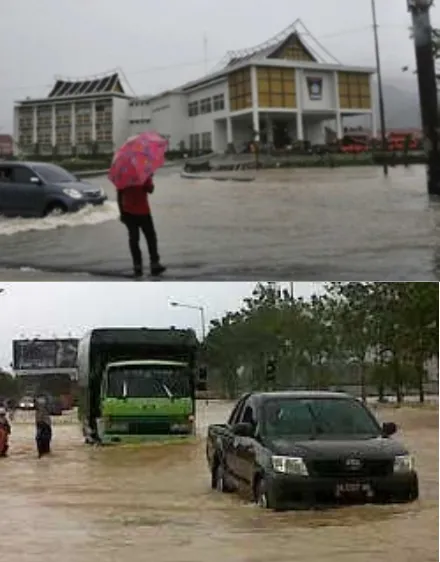
As a results, it seems there is an increase of flood frequency in this area. As noted by Istijono [1], there has been 12 flood occurrences between 2011 and 2013 in Air Pacah. Damage and losses into property, economic disruption, fatalities are evitable. Fig 1 shows where Padang Bypass road can not be passed by vehicle.
To overcome the problems, government has tried to mitigate flood events, one of them is by carrying out a flood control project in Maransi River and Luruih River which pass through Air Pacah area. The construction of this project was planned for 2200 meters long and implemented from 2012 to 2014 by Water Resources Department of West Sumatra Province. However, due to land acquisition problem by the Government of Padang City, river widening work can only be carried out for 840 meters. As a result, the expected benefit of the flood control project is not optimal. Accordingly, the purpose of this paper is to find out how the public perception of flood events that occurred in the area of Air Pacah and
into what extent community perceived the benefits of the flood control project.
International Conference on Innovative Trends in Civil Engineering for Sustainability (ICICES-2016)
2. Literature Study
2.1.Flood, Causes, and Mitigation
According to BNPB [2] flood is water runoff whichexceed its normal confines, Istijono [1] adds that flood process can be explained. MenurutIstijono [1]the occurrence of flooding can be explained by looking at surface run-off which is equal to the total volume of rainwater deducted by interception of water, water infiltration, water storage, water evaporation, and plant transpiration. This factor can be simplified into:
AP = VH – ( C + R + T ) (1)
where AP is the flow of surface water, VH is the volume of rainwater, C is water interception, R is infiltration area, and T is water reservoir.
The value of AP will be greater if the value of C, R and T are small, and vice versa AP value will be small if the value of C, R and T are large. The greater the flow of surface water, the greater the potential of flooding event, and if AP exceeds the carrying capacity of the river then flood will occur.
In more detail Kodoatie and Sugiyanto[3] classify the causes of flooding into two factors, natural factors and human factors. Naturally the cause of flood is heavy rainfall, the effect of physiography, erosion and sedimentation, low capacity of rivers, inadequate drainage capacity, and the influence of tide. While the causes of flood due to human actions are the changing conditions of river bank, slums area, litter, dams, damage to flood control building, and inappropriate flood control systems.
For flood control, further Kodoatie and Sugiyanto[3] explain that there are two approaches can be made, non- structural and structural methods. Non- structural methods include watersheds management, land use regulation, erosion control in the watershed, flood warning system, and legal approach. While the structure method include by construction of dams, retention ponds, check dams, reducing the slope of a stream, river improvement, diversion, and construction of embankment.
2.2.Flood in Padang City
Padang City is the capital of West Sumatra province. Administratively, the city of Padang is composed of 11 districts and 104 villages. According to BPS [4] the population of Padang City in 2014 is 876.678 inhabitants and population density is 1261 inhabitants/km2. In 2013, the rate of precipitation of Padang reached an average of 347.50 mm per month with an average of 18.83 days of rainy days per month.
As Padang city is located in lowlands with relatively flat topography and next to the beach, and is passed by five major rivers and 16 small rivers, the city was frequently inundated by flood. Indonesian disaster data and
information (DIBI) [5] notes that from 2002 to 2015 there has been 32 occurrences of floods in Padang City. One of the area which is often flooded is Air Pacaharea.
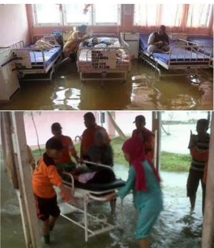
Most recent flood events are flood on March 16, 2008 at Kuranjiriver and LimauManis river, flood on 24 July 2012 and 12 September 2012 (Hidayat, [6]). The last flood event have pushed some houses to be relocated to a safer place. On Wednesday, September 4, 2013 floods in Air Pacah caused Padang Bypass road impassable (Figure 1) and lead to Padang City Hospital patients had to be evacuated (Figure 2).
Figure 2. Flood in Local Hospital of Padang City in Air Pacah area
2.3.Flood Control
Flood control structure has been carried out Padang City dating back during Dutch colonial era which marked by the construction of Banda BatangBakali (digging river). This project is carried out to divert some of the flow of ArauRiver which passing through the trade center of Padang at the time.
International Conference on Innovative Trends in Civil Engineering for Sustainability (ICICES-2016)
Some projects that have been implemented for flood control in Padang city are normalization of Flood Canal and BatangArauriver in 1992-1997, Kuranji river normalization, Padang coast defence system, and the most current flood control project, Maransi river year 2012-2014.
2.4. Community Perception
According to Bahasa Indonesia dictionary (KKBI) [8], perception can be interpreted as a response (acceptance) directly from something or what someone knows through the senses. Referring to this definition, community perception is how community perceived the flood events that occurred in the area of Air Pacah.
3. Case Study
Case study on this research is associated with the flood control project at Luruih/MaransiRiver in Air Pacah area. With this project, it is expected that Air Pacaharea as the center of Padang City would be a flood-free areas. The consequence is that the government should increase LuruihRiver and MaransiRiver capacity so it will be able to accommodate the flood discharge over a period of 25 years 120 m3/sec and 34 m3/sec respectively.
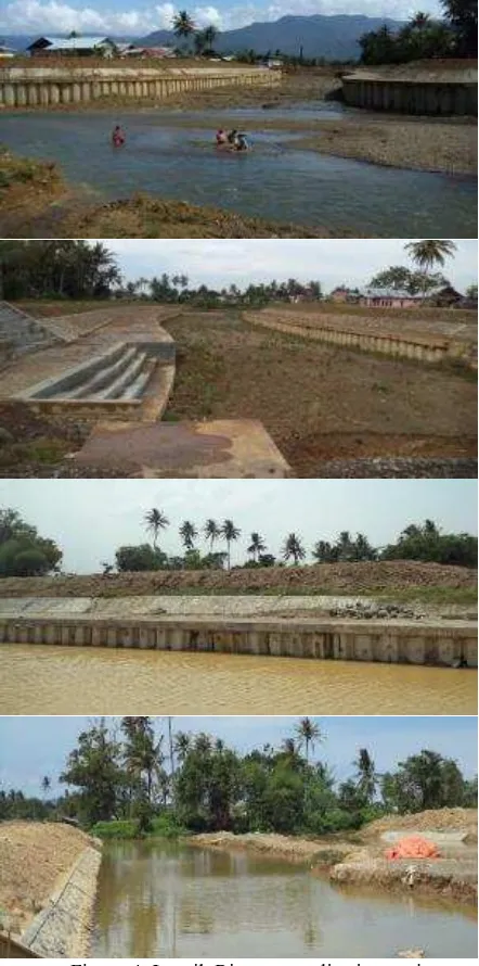
Figure 3. Project layout and land acquisition. (source: Dinas PSDA Sumbar)
The detail location of the project is shown in Figure 3. The funding is come from the West Sumatra provincial
budget with a contract value of Rp. 30 billion (USD $ 2.5 million), implemented with a multi-year contract from 7 December 2012 until 6 November 2014. Initial plan was to conduct 2400 m river normalization. However, due to land acquisition problem, the project can only be carried out along 840 meters. Chronologically, the distance of land that can be acquired is 150 meters in 2012, 250 meters in 2013, and 440 meters in 2014.
Forms of activities that have been carried out from 2012 to 2014 include the construction of estuaries, dike and canal wall (Figure 4).
Figure 4. Luruih River normalisation project (source: Dinas PSDA Sumbar)
LOKASI PROYEK YANG BISA
Padang City
Land acquisition map for river normalization project Land acquisition plan in 2016
Land acquisition plan in 2015
Project location (840 m)
International Conference on Innovative Trends in Civil Engineering for Sustainability (ICICES-2016)
4. Methodology
This paper was a further development from a preliminary research regarding community perception at AiaPacah area (see Ophiyandri et al., [9]). Previous study was conducted using 20 respondents which become an issue on its validity and reliability. As a result, this study was resulted from 30 semi-structure interviews. The interviews were conducted between May and October 2015. Sampling method used is a purposive sampling, where the respondents has to be lived in Air Pacah area before 1999.
Respondents profile is shown in Table 1. It can be seen that the average age of respondents is 43.4 years and majority respondents have lived in this area more than 35years. None of respondents graduated from university and majority of them working as a farmer.
The interview guideline is structured into four sections, where the first section is about respondents details, and
the second and the fourth sections are about community perception towards flood based on time occurrences, before 1999, between 1999 and 2012 (before the flood control project begin), and after 2012. Respondents were invited to share their opinion about flood causes, frequency, impact, and especially for questions after 2012 respondents were asked whether they already have benifited from the project. For this section, the area is devided into three: (1) KuraoPagang where the construction project was exactly taken place, (2) GunungSangku, 1.5 km upstream from construction area and at the west of Padang Bypass road, and (3) BatangLuruih, 2.5 km upstream from construction area and the east side of Padang Bypass road. From 30 respondents, 11 respondents live in KuraoPagang, 10 respondents live in GunungSangku, and 9 respondents live in BatangLuruih. Further, data was analysed using descriptive statistics and content analysis.
Table 1. Respondent profile
Age (years) Lived in Air Pacah (years) Educational Background Occupation Description Age Description Total Description Total Description Total
Min 22 0-20 1 Non educated 1 Businessman 7
Max 75 20-35 8 Elementary 10 Farmer 14
Average 43.4 35-55 11 Junior High Sc 10 Housewife 8
>55 10 Senior High Sc 9 Others 1
5. Results and discussion
5.1.Frequency and Flood Height
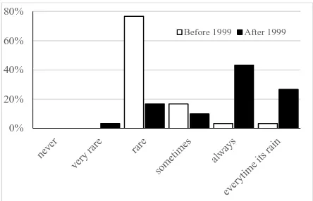
Community perception towards flood frequency and flood depth were shown in Figure 5 and Figure 6. It can be seen from Figure 5 that before 1999, 77% of respondents said that flood was rarely occurred in Air Pacah. However, after 1999, majority of respondents (43%) claim that flood was always occurred, and unexpectedly 27% of them said that flood occurred every time rain poured. It implies that the flood frequency increase significantly.
Figure 5. Community perception towards flood frequency
Figure 6. Community perception towards flood depth.
Figure 6 shows the average of flood depth according to community. Before 1999, 70% of respondents said that the average of flood depth is less than 50 cm. After 1999, respondents which say that the average depth was less than 50 cm decrease into 43%. Majority of respondents said that the flood depth was between 0.5 and 1 meter.
Respondents were also asked about the maximum height of flood and flood duration. According to them, there is an increase in the average of highest flood depth, from 28 cm before year 1999 to 71 cm after year 1999. The time of flood duration also rise from 4.7 hours before year 1999 to 13.3 hours after year 1999.
0% 20% 40% 60% 80%
Before 1999 After 1999
0% 20% 40% 60% 80%
International Conference on Innovative Trends in Civil Engineering for Sustainability (ICICES-2016)
5.2.Flood Causes
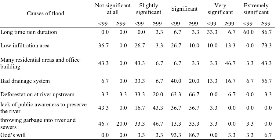
Table2 shows the causes of flood according to community perceptions. From 8 factors introduced, at the time period before 1999, only one factor has an extremely significant impact to flood, which is ‘a long time rain duration’. Sixty five percent of respondents agrees with this opinion. At the time period after 1999, majority of respondents said that there are four factors classified as an extremely significant contribution to flood. They are ‘long rain time duration’, ‘low infiltration area’, ‘many residential areas and offices building’, and ‘bad drainage system.
There is a significant shift on three factors according to time analysed (before 1999 and after 1999), namely low infiltration area due to the construction, the increasing
number of residential area and office buildings, as well as bad drainage system. The last is inline with Kamil [10]. In the period before 1999, people thought that the lack of water infiltration areas and the rapid development as a factor that 'not significant at all'. This factor increases to 'extremely significant' and ‘very significant’ respectively in the period after 1999. While the drainage conditions transform from 'significant' to 'extremely significant'.
Furthermore, the public perception of the length of rain time, deforestation, and the will of God is not shifted between categories before and after 1999. The length of rain time is still considered as a factor that "extremely significant”, while deforestation and God’s will destiny remain in the ‘significant’ category.
Table 2. Percentage of community perception to the causes of flood (before and after 1999)
Causes of flood
Not significant at all
Slightly
significant Significant
Very significant
Extremely significant
<99 ≥99 <99 ≥99 <99 ≥99 <99 ≥99 <99 ≥99
-Long time rain duration 0.0 0.0 0.0 3.3 6.7 3.3 33.3 6.7 60.0 86.7
-Low infiltration area 36.7 0.0 26.7 3.3 26.7 10.0 10.0 13.3 0.0 73.3
-Many residential areas and office
building 43.3 0.0 43.3 6.7 6.7 3.3 3.3 46.7 3.3 43.3
-Bad drainage system 6.7 0.0 33.3 6.7 40.0 20.0 13.3 16.7 6.7 56.7
-Deforestation at river upstream 3.3 3.3 33.3 20.0 63.3 66.7 0.0 6.7 0.0 3.3
-lack of public awareness to preserve
the river 43.3 0.0 16.7 43.3 36.7 56.7 3.3 0.0 0.0 0.0
-throwing garbage into river and
sewers 46.7 20.0 33.3 46.7 13.3 33.3 3.3 0.0 3.3 0.0
-God’s will 0.0 0.0 3.3 3.3 93.3 86.7 0.0 3.3 3.3 6.7
5.3.Impact of flood control project
This section will discuss what the respondents' perceptions on flood control and the impact that they have felt since project construction. As explained in the methodology section, for this section the study area is divided into three locations. All respondents stated that they had been aware of the activities, which in general they know from other community (60%) with 13 % stating that they know from a socialization carried out by the government.
Since the flood control project was implemented only 9 respondents (30 %) stating that there has been a decrease in the frequency of flood in this area, and all of stating this is that people who live in the area KuraoPagang (near the project site ). Respondent 1 states that:
"... In the past, prior to this project, we experienced flood, water inundated a lot of places, our rice fields were flooded and sometimes washaway. After the construction, when raining, water flows smoothly and does not block anymore."
Respondent 2 added that there is a decrease in flood height level. He stated:
"Since the flood control project taking place, we were not experiencing flood anymore. Before, the flood height was three hollow brick, but now less than one hollow brick"
International Conference on Innovative Trends in Civil Engineering for Sustainability (ICICES-2016)
"When its rain for 3 hours, rain is turning into pond. Padang bypass roas blocked the water flow, causing floods’.
Respondent 4 adds :
"In the past, flood only happened when its raining for all day, but now, only a few hours our area becoming flooded, as height as adult’s knee. In Junior High School 27, the flood was higher, forced the school to close."
From above, it can be stated that the people who live close to the flood control project already feel the benefits of this project. Community at this location perceive that there has been a decrease in the intensity of floods. While those who are at a bit far from the project site (toward upstream) have not yet benefited from this activity. Considering this benefits, then it is highly recommended that the government to immediately do land acquisation programme.
6. CONCLUSION AND RECOMMENDATION
6.1.Conclusion It can be concluded that:
1.
The community perceives that there has been an increase in flood frequency, flood height, as well as the length of flood time between the period before 1999 compared to the period after 1999 .2.
Prior to the rapid development in Air Pacah area, factors that have extremely significant impact on flood is just the length of rainy time. While after 1999, there are four very influential factors on the occurrence of flood, the length of rainy time, lack of water inflitration areas, the number of residential area and office buildings , as well as poor drainage conditions3.
Community who live near the location of flood control already feel the positive impact of this project. While community who live slightly upstream from the project site has yet to feel the benefits of this project.6.2.Recommendation
The construction of Maransi River flood control project was hampered by land acquisition. By looking at the benefit that already felt by some community, it is strongly suggested that the government of Padang City to immediately acquire the land needed for flood control project.
7. REFERENCES
[1] Istijono, B. (2014) The Obstacles of Infrastructure Project: Case Study on Flood Control Project in Air Pacah (in Bahasa: Hambatan Pembangunan InfrastrukturAkibatPembebasanLahan:
KasusPekerjaanPengendalianBanjirKawasan Air Pacah
Kota Padang). Proceeding 1stAndalas Civil
Engineering National Conference, 27 November 2014, Padang.
[2] BNPB (2013) Indonesia Disaster Risk Index (in Bahasa: IndeksRisikoBencana Indonesia (IRBI) Tahun 2013. BadanPenanggulanganBencana Indonesia (BNPB).
[3] Kodoatie, R. J. danSugiyanto, 2002. Flood: causes and mitigation on environment perspective (In
bahasa: Banjir:
Beberapapenyebabdanmetodepengendaliannyadala mperspektiflingkungan,) PustakaPelajar, Yogyakarta.
[4] BPS (2015) Padang in Numbers 2014 (in Bahasa:
Padang dalamAngka 2014.
http://padangkota.bps.go.id/vertwo/index.php?hal= publikasi_detil&id=11 pdf [accessed on 20 Juni 2015]
[5] DIBI (2015) Indonesia Disaster data and
Information (In Bahasa: Data
danInformasiBencana Indonesia).
http://dibi.bnpb.go.id/data-bencana/lihat-data/per-halaman=100;halaman=1 pdf [accessed on 15 Juli 2015]
[6] Hidayat, B (2014) Understanding Flood in Padang City with Content Analysis of News Article. (inBahasa: MemahamiBencanaBanjir di Kota Padang dengan Content Analysis ArtikelBerita). XXXI HATHI Conference, 22-24 August 2014, Padang
[7] JICA (1983) Study Report on Padang Area Flood Control Project. Japan International Cooperation Agency (JICA).
[8] KKBI (2015) Indonesia Dictionary (In Bahasa:
KamusBesarBahasa Indonesia.
http://kbbi.web.id/persepsi. [accessed on 15 Juli 2015]
[9] Ophiyandri, T., Istijono, B., Annisa, Musri, A., Daus, S. and Yuhendra, R. (2015) Community Perception on Flood in Air Pacah Area Padang City, XXXII Annual Scientific Meeting of the
Association of Indonesian Hydraulic Engineer,
Malang, Indonesia, 6-8 November 2015.