Open Geospatial Consortium
Publication Date: 2013-06-18
Approval Date: 2013-03-22
Posted Date: 2013-01-02
Reference number of this document: OGC 12-155
Reference URL for this document: http://www.opengis.net/def/doc-type/per/ows9-wcs-lidar
Category: Engineering Report
Editors: Weiguo Han, Yuanzheng Shao, Liping Di
OGC
®OWS-9 OWS Innovations WCS for LIDAR
Engineering Report
Report
Copyright © 2013 Open Geospatial Consortium.
To obtain additional rights of use, visit http://www.opengeospatial.org/legal/.
Warning
This document is not an OGC Standard. This document is an OGC Public
Engineering Report created as a deliverable in an OGC Interoperability Initiative and is not an official position of the OGC membership. It is distributed for review and comment. It is subject to change without notice and may not be referred to as an OGC Standard. Further, any OGC Engineering Report should not be referenced as required or mandatory technology in procurements.
Document type: OGC® Engineering Report
Document subtype: NA
Document stage: Approved for public release
OGC 12-155
ii Copyright © 2013 Open Geospatial Consortium.
Abstract
This Engineering Report is prepared as a deliverable for the OGC Web Services, Phase 9 (OWS-9) initiatitive of the Innovations Coverages Sub-Thread. This document represents the OWS-9 OWS Innovations WCS for LIDAR Engineering Report. In this report, the implementation of WCS 2.0 service that serves the LIDAR data in NITF format is introduced. This service supports the JPEG 2000 output format along with GMLJP2 metadata description as well as the JPIP protocol to deliver the output JPEG2000 data.
Keywords
ogcdoc, OGC document,ows9, ows-9, wcs, lidar, jpip
What is OGC Web Services 9 (OWS-9)?
OWS-9 builds on the outcomes of prior OGC interoperability initiatives and is organized around the following threads:
- Aviation: Develop and demonstrate the use of the Aeronautical Information Exchange Model (AIXM) and the Weather Exchange Model (WXXM) in an OGC Web Services environment, focusing on support for several Single European Sky ATM Research (SESAR) project requirements as well as FAA (US Federal Aviation Administration) Aeronautical Information Management (AIM) and Aircraft Access to SWIM (System Wide Information Management) (AAtS) requirements.
- Cross-Community Interoperability (CCI): Build on the CCI work accomplished in OWS–8 by increasing interoperability within communities sharing geospatial data, focusing on semantic mediation, query results delivery, data provenance and quality and Single Point of Entry Global Gazetteer.
- Security and Services Interoperability (SSI): Investigate 5 main activities: Security Management, OGC Geography Markup Language (GML) Encoding Standard
Application Schema UGAS (UML to GML Application Schema) Updates, Web Services Façade, Reference Architecture Profiling, and Bulk Data Transfer.
- OWS Innovations: Explore topics that represent either new areas of work for the Consortium (such as GPS and Mobile Applications), a desire for new approaches to existing technologies to solve new challenges (such as the OGC Web Coverage Service (WCS) work), or some combination of the two.
- Compliance & Interoperability Testing & Evaluation (CITE): Develop a suite of compliance test scripts for testing and validation of products with interfaces
OGC 12-155
Copyright © 2013 Open Geospatial Consortium. iii
Language (GML) 3.2.1 Encoding Standard, OWS Context 1.0 (candidate encoding standard), Sensor Web Enablement (SWE) standards, Web Coverage Service for Earth Observation (WCS-EO) 1.0 Interface Standard, and TEAM (Test, Evaluation, And Measurement) Engine Capabilities.
OGC 12-155
iv Copyright © 2013 Open Geospatial Consortium.
License Agreement
Permission is hereby granted by the Open Geospatial Consortium, ("Licensor"), free of charge and subject to the terms set forth below, to any person obtaining a copy of this Intellectual Property and any associated documentation, to deal in the Intellectual Property without restriction (except as set forth below), including without limitation the rights to implement, use, copy, modify, merge, publish, distribute, and/or sublicense copies of the Intellectual Property, and to permit persons to whom the Intellectual Property is furnished to do so, provided that all copyright notices on the intellectual property are retained intact and that each person to whom the Intellectual Property is furnished agrees to the terms of this Agreement.
If you modify the Intellectual Property, all copies of the modified Intellectual Property must include, in addition to the above copyright notice, a notice that the Intellectual Property includes modifications that have not been approved or adopted by LICENSOR.
THIS LICENSE IS A COPYRIGHT LICENSE ONLY, AND DOES NOT CONVEY ANY RIGHTS UNDER ANY PATENTS THAT MAY BE IN FORCE ANYWHERE IN THE WORLD.
THE INTELLECTUAL PROPERTY IS PROVIDED "AS IS", WITHOUT WARRANTY OF ANY KIND, EXPRESS OR IMPLIED, INCLUDING BUT NOT LIMITED TO THE WARRANTIES OF MERCHANTABILITY, FITNESS FOR A PARTICULAR PURPOSE, AND NONINFRINGEMENT OF THIRD PARTY RIGHTS. THE COPYRIGHT HOLDER OR HOLDERS INCLUDED IN THIS NOTICE DO NOT WARRANT THAT THE FUNCTIONS CONTAINED IN THE INTELLECTUAL PROPERTY WILL MEET YOUR REQUIREMENTS OR THAT THE OPERATION OF THE INTELLECTUAL PROPERTY WILL BE
UNINTERRUPTED OR ERROR FREE. ANY USE OF THE INTELLECTUAL PROPERTY SHALL BE MADE ENTIRELY AT THE USER’S OWN RISK. IN NO EVENT SHALL THE COPYRIGHT HOLDER OR ANY CONTRIBUTOR OF
INTELLECTUAL PROPERTY RIGHTS TO THE INTELLECTUAL PROPERTY BE LIABLE FOR ANY CLAIM, OR ANY DIRECT, SPECIAL, INDIRECT OR CONSEQUENTIAL DAMAGES, OR ANY DAMAGES WHATSOEVER RESULTING FROM ANY ALLEGED INFRINGEMENT OR ANY LOSS OF USE, DATA OR PROFITS, WHETHER IN AN ACTION OF CONTRACT, NEGLIGENCE OR UNDER ANY OTHER LEGAL THEORY, ARISING OUT OF OR IN CONNECTION WITH THE IMPLEMENTATION, USE, COMMERCIALIZATION OR PERFORMANCE OF THIS INTELLECTUAL PROPERTY.
This license is effective until terminated. You may terminate it at any time by destroying the Intellectual Property together with all copies in any form. The license will also terminate if you fail to comply with any term or condition of this Agreement. Except as provided in the following sentence, no such termination of this license shall require the termination of any third party end-user sublicense to the Intellectual Property which is in force as of the date of notice of such termination. In addition, should the Intellectual Property, or the operation of the Intellectual Property, infringe, or in LICENSOR’s sole opinion be likely to infringe, any patent, copyright, trademark or other right of a third party, you agree that LICENSOR, in its sole discretion, may terminate this license without any compensation or liability to you, your licensees or any other party. You agree upon termination of any kind to destroy or cause to be destroyed the Intellectual Property together with all copies in any form, whether held by you or by any third party.
Except as contained in this notice, the name of LICENSOR or of any other holder of a copyright in all or part of the Intellectual Property shall not be used in advertising or otherwise to promote the sale, use or other dealings in this Intellectual Property without prior written authorization of LICENSOR or such copyright holder. LICENSOR is and shall at all times be the sole entity that may authorize you or any third party to use certification marks, trademarks or other special designations to indicate compliance with any LICENSOR standards or specifications.
This Agreement is governed by the laws of the Commonwealth of Massachusetts. The application to this Agreement of the United Nations Convention on Contracts for the International Sale of Goods is hereby expressly excluded. In the event any provision of this Agreement shall be deemed unenforceable, void or invalid, such provision shall be modified so as to make it valid and enforceable, and as so modified the entire Agreement shall remain in full force and effect. No decision, action or inaction by LICENSOR shall be construed to be a waiver of any rights or remedies available to it.
OGC 12-155
Copyright © 2013 Open Geospatial Consortium. v
Contents
1 Introduction ... 1
1.1 Scope ... 1
1.2 Document contributor contact points ... 1
1.3 Revision history ... 1
1.4 Forward ... 2
2 References ... 2
3 Terms and definitions ... 2
3.1 JPEG2000 ... 2
3.2 JPIP ... 2
3.3 NITF ... 3
4 Conventions ... 3
4.1 Abbreviated terms ... 3
4.2 UML notation ... 4
5 Overview ... 4
6 GMLJP2 WCS implementation ... 5
6.1 Data selection ... 5
6.2 Metadata interoperability ... 7
6.3 WCS implementation ... 7
6.4 WCS usage ... 8
6.5 JPIP protocol support ... 8
7 Future work ... 8
Annex A: GMLJP2 XML document for the sample data ... 9
Annex B: Request parameters of GMLJP2 WCS ... 12
Annex C: Request and response of GetCoverage for JPIP coverage ... 15
OGC® Engineering Report OGC 12-155
Copyright © 2013 Open Geospatial Consortium. 1
OGC
®OWS-9 OWS Innovations WCS for LIDAR
Engineering Report
Report
1 Introduction
1.1 Scope
This document represents the OWS-9 OWS Innovations WCS for LIDAR Engineering Report. In this report, the implementation of WCS 2.0 service that serves the LiDAR HRE data in NITF format is introduced. This service supports the JPEG 2000 output format along with GMLJP2 metadata description as well as the JPIP protocol to deliver the output JPEG2000 data.
This document is applicable to OGC® GML in JPEG 2000 for Geographic Imagery (GMLJP2) Implementation Specification [OGC 05-047r2] and OGC® Web Coverage Service 2.0 – Core [OGC 09-110r4] along with its extensions.
1.2 Document contributor contact points
All questions regarding this document should be directed to the following editors or the contributors:
Name Organization
Weiguo Han ([email protected]) Center for Spatial Information Science and Systems,
George Mason University
Yuanzheng Shao ([email protected]) Center for Spatial Information Science and Systems,
George Mason University
Liping Di ([email protected]) Center for Spatial Information Science and Systems,
George Mason University
1.3 Revision history
Date Release Editor Primary clauses modified Description
2012-10-02 0.1 Yuanzheng Shao,
Weiguo Han
All Initial version
2012-12-03 0.2 Yuanzheng Shao,
Weiguo Han
Section 4, 5, 6 Add the detailed
implementation framework
2012-12-17 1.0 Weiguo Han,
Yuanzheng Shao
OGC 12-155
2 Copyright © 2013 Open Geospatial Consortium.
1.4 Forward
Attention is drawn to the possibility that some of the elements of this document may be the subject of patent rights. The Open Geospatial Consortium shall not be held
responsible for identifying any or all such patent rights.
Recipients of this document are requested to submit, with their comments, notification of any relevant patent claims or other intellectual property rights of which they may be aware that might be infringed by any implementation of the standard set forth in this document, and to provide supporting documentation.
2 References
The following documents are referenced in this document. For dated references, subsequent amendments to, or revisions of, any of these publications do not apply. For undated references, the latest edition of the normative document referred to applies.
- OGC 06-121r9, OGC® Web Services Common Standard, Version 2.0
- OGC 05-047r2, OGC® GML in JPEG 2000 for Geographic Imagery (GMLJP2) Implementation Specification, Version 1.0
- OGC 09-110r3, OGC® Web Coverage Service 2.0 Interface Standard Core, Version 2.0
- NGA.IP.0002_1.0, NGA Standardization Document - Implementation Profile for High Resolution Elevation (HRE) Products, Version 1.0
3 Terms and definitions
For the purposes of this report, the definitions specified in Clause 4 of the OWS Common Implementation Standard [OGC 06-121r3] and in GML in JPEG 2000 for Geographic Imagery (GMLJP2) Implementation Specification [OGC 05-047r2] shall apply. In addition, the following terms and definitions apply:
3.1 JPEG2000
JPEG 2000 is an image compression standard and coding system. It was created by the Joint Photographic Experts Group (JPEG) committee in 2000 with the intention of superseding their original discrete cosine transform-based JPEG standard (created in 1992) with a newly designed, wavelet-based method.
3.2 JPIP
OGC 12-155
Copyright © 2013 Open Geospatial Consortium. 3
useful for medical and environmental awareness purposes, among others, and many implementations of it are currently being produced.
3.3 NITF
The National Imagery Transmission Format Standard (NITFS) is a U.S. Department of Defense (DoD) and Federal Intelligence Community (IC) suite of standards for the exchange, storage, and transmission of digital-imagery products and image-related products.
4 Conventions
4.1 Abbreviated terms
API Application Programming Interface
ESA European Space Agency
DoD Department of Defense
GDAL Geospatial Data Abstraction Library
GMLCOV OGC GML 3.2.1 Application Schema – Coverages
GMU George Mason University
HRE High Resolution Elevation
IC Intelligence Community
JPEG Joint Photographic Experts Group JPIP JPEG 2000 Interactive Protocol LiDAR Light Detection And Ranging
NGA National Geospatial-Intelligence Agency NITF National Imagery Transmission Format
OWS OGC Open Web Service
OWS-9 OGC Web Services Initiative, Phase 9
SDK Software Development Kit
TRE Tagged Record Extension
OGC 12-155
4 Copyright © 2013 Open Geospatial Consortium.
WCS Web Coverage Service
4.2 UML notation
Diagrams presented using the Unified Modeling Language (UML) static structure diagram follow Subclause 5.2 of [OGC 06-121r3].
5 Overview
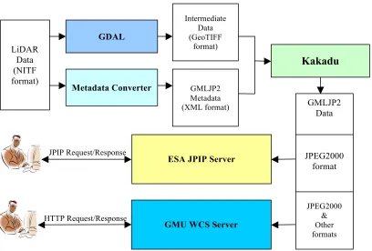
This report introduces the technical implementation of GMLJP2 WCS service for the LiDAR HRE data in NITF format with its native Tagged Record Extension (TRE). A general program is built to convert data from NITF format to JPEG2000 format and transform native TREs to GML metadata. Moreover, a JPIP server is set up to deliver the response of WCS to clients using JPIP protocol.
Open source geospatial package Geospatial Data Abstraction Library (GDAL) is utilized in data reformatting and re-projection because it supports multiple geospatial data
formats, including GeoTIFF and NITF. However, GDAL does not support the JPEG2000 format with its default configuration, so it is re-configured with OpenJPEG library (or Japser library) to support JPEG2000 format in the GMU GMLJP2 WCS implementation. ESA JPIP server is configured to support JPIP protocol in the implementation. It is found that ESA JPIP server doesn’t support the JPEG2000 file generated from GDAL directly. So Kakadu software (including command line tools and APIs, freely obtained from Kakadu Software, www.kakadusoftware.com) is adopted to generate the output data in JPEG2000 format.
In the implementation, GeoTIFF serves as an intermediate data format between NITF and JPEG2000, that is, the original source data in NITF format is converted to the one in GeoTIFF format using GDAL, and then the GeoTIFF file is converted to the output JPEG200 file using Kakadu. A metadata converter is developed to transform metadata information in NITF format to GMLJP2 metadata in XML format. Finally, ESA JPIP server will deliver the responses in JPIP protocol, and GMU WCS server is responsible for handling the HTTP requests.
OGC 12-155
Copyright © 2013 Open Geospatial Consortium. 5
Figure 1. GMU GMLJP2 WCS implementation framework
6 GMLJP2 WCS implementation
6.1 Data selection
The following four LiDAR HRE sample files provided by NGA are used in the implementation and testing of the GMLJP2 WCS service:
Case1_HRE10G324642N1170747W_Uxx.hr5
Case2_HRE10G324642N1170747W_Uxx.hr5
Case3_HRE10G324642N1170747W_Uxx.hr5
Case4_HRE10G324642N1170747W_Uxx.hr5
These HRE files are in NITF format and their metadata information are described in the NITF Headers/Sub-Header and TREs. Taking the sample data of
Case1_HRE10G324642N1170747W_Uxx.hr5 as an example, its headers, sub-headers and TREs are retrieved and listed as the following:
1) Header information
<headers>
<field name="CLEVEL" value="03"/> <field name="ENCRYP" value="0"/> <field name="FBKGC" value="000000"/> <field name="FDT" value="20081201000000"/> <field name="FHDR" value="NITF02.10"/>
JPIP Request/Response
Metadata Converter GMLJP2 Metadata (XML format)
ESA JPIP Server
HTTP Request/Response
OGC 12-155
6 Copyright © 2013 Open Geospatial Consortium.
<field name="FSCATP" value=""/> <field name="FSCAUT" value=""/> <field name="FSCLAS" value="U"/> <field name="FSCLSY" value="US"/> <field name="FSCLTX" value=""/> <field name="FSCODE" value=""/> <field name="FSCOP" value="00000"/> <field name="FSCPYS" value="00000"/> <field name="FSCRSN" value=""/> <field name="FSCTLH" value="FO"/> <field name="FSCTLN" value=""/> <field name="FSDCDT" value=""/> <field name="FSDCTP" value=""/> <field name="FSDCXM" value=""/> <field name="FSDG" value=""/> <field name="FSDGDT" value=""/> <field name="FSREL" value=""/> <field name="FSSRDT" value=""/>
<field name="FTITLE" value="HRE High Resolution Elevation Data HRE10G324642N1170747W_Uxx.hr5"/> <field name="ONAME" value="NGA"/>
<field name="OPHONE" value="1-800-455-0899"/> <field name="OSTAID" value="NGA"/>
<field name="STYPE" value="BF01"/> </headers>
2) Sub-header information
<subheaders>
<field name="ABPP" value="32"/> <field name="CCS_COLUMN" value="0"/> <field name="CCS_ROW" value="0"/> <field name="IALVL" value="0"/> <field name="IC" value="NC"/> <field name="ICAT" value="DTEM"/> <field name="ICORDS" value="D"/>
<field name="IDATIM" value="20041201000000"/> <field name="IDLVL" value="1"/>
<field name="IGEOLO" value="+32.781-117.129+32.781-117.126+32.778-117.126+32.778-117.129"/> <field name="IID1" value="HRE"/>
OGC 12-155
Copyright © 2013 Open Geospatial Consortium. 7
<field name="ISORCE" value="IFSAR"/> <field name="ISREL" value=""/> <field name="ISSRDT" value=""/> <field name="PJUST" value="R"/> <field name="PVTYPE" value="R"/> <field name="TGTID" value=""/> </subheaders>
3) TREs information
<tres>
<tre name="PIAPRD" location="file"> <field name="ACCESSID" value=""/>
<field name="PRODCRTIME" value="20081201000000"/> <field name="MAPID" value=""/>
To implement the GMLJP2 WCS service, the metadata of headers, sub-headers, and NITF TREs will be converted to the GMLJP2 elements according to the schema files, which are provided by the sponsor. The specific schema files are obtained from the following link:
https://portal.opengeospatial.org/files/?artifact_id=50045
Taking the sample data of Case1_HRE10G324642N1170747W_Uxx.hr5 as an example, its headers/sub-headers and TREs are converted to the corresponding elements in
GMLJP2 (Refer to Annex A).
6.3 WCS implementation
OGC 12-155
8 Copyright © 2013 Open Geospatial Consortium.
GetCapabilities
DescribeCoverage
GetCoverage
Currently, only HTTP/GET method is supported.
If the output format is specified as image/jpeg2000, this WCS service will insert the GMLJP2 metadata to the XML box in the output JPEG2000 data by calling API function of Kakadu SDK.
6.4 WCS usage
The request parameters and sample URL are listed in Annex B. 6.5 JPIP protocol support
The JPIP server also is set up to support the delivery of the generated JPEG2000 data via JPIP protocol.
To get the output data via JPIP protocol, the output format in the GetCoverage request needs to be specified as the following:
format=text/xml;urn:ogc:def:wcs:2.0:jpip-response
The request and response example are given in Annex C.
Annex D introduces how to visualize the JPIP stream and check the GMLJP2 metadata
information via the third-party JPIP client software. 7 Future work
OGC 12-155
Copyright © 2013 Open Geospatial Consortium. 9
Annex A: GMLJP2 XML document for the sample data
<?xml version="1.0" encoding="UTF-8"?>
<gmljp2:RootFeatureCollection xmlns:geopsb="http://www.example.org/nitf/tre/geopsb" xmlns:geolob="http://www.example.org/nitf/tre/geolob"
xmlns:histoa="http://www.example.org/nitf/tre/histoa" xmlns:saxon="http://saxon.sf.net/" xmlns:maplob="http://www.example.org/nitf/tre/maplob"
xmlns:prjpsb="http://www.example.org/nitf/tre/prjpsb"
xmlns:piaprd="http://www.example.org/nitf/tre/piaprd" xmlns:xlink="http://www.w3.org/1999/xlink" xmlns:eop="http://www.opengis.net/eop/2.0" xmlns:gml="http://www.opengis.net/gml/3.2"
xmlns:ntf="http://www.example.org/nitf" xmlns:gmlcov="http://www.opengis.net/gmlcov/1.0" xmlns:om="http://www.opengis.net/om/2.0" xmlns:gmljp2="http://www.opengis.net/gmljp2/2.0"
xmlns:swe="http://www.opengis.net/swe/2.0" xmlns:xsi="http://www.w3.org/2001/XMLSchema-instance" xsi:schemaLocation="http://www.example.org/nitf
http://129.174.131.8:9003/ows9_ic/schema/gmljp2v2.0/NITF_2.1.xsd http://www.example.org/nitf
gml:id="FC001"> <ntf:sourceFileMetadata> <ntf:FileHeader>
OGC 12-155
10 Copyright © 2013 Open Geospatial Consortium.
</ntf:xhd> </ntf:FileHeader> </ntf:sourceFileMetadata> <gmljp2:featureMember>
<gmljp2:CodeStreamData gml:id="CodeStream1">
<gml:boundedBy xmlns:wcs="http://www.opengis.net/wcs/2.0" xmlns:wcseo="http://www.opengis.net/wcseo/1.0">
<gml:Envelope axisLabels="lon lat" srsDimension="2"
OGC 12-155
Copyright © 2013 Open Geospatial Consortium. 11
</ntf:ImageSubheader> </ntf:imageMetadata> <gmljp2:coverage>
<ntf:RectifiedGridCoverage gml:id="RectifiedGrid1"> <gml:rectifiedGridDomain>
<gml:RectifiedGrid xmlns:wcs="http://www.opengis.net/wcs/2.0" xmlns:wcseo="http://www.opengis.net/wcseo/1.0" dimension="2" gml:id="Case1_HRE10G324642N1170747W_Uxx.hr5_grid"> <gml:limits>
<gml:GridEnvelope> <gml:low>0 0</gml:low> <gml:high>333 357</gml:high> </gml:GridEnvelope>
</gml:limits>
<gml:axisLabels>lon lat</gml:axisLabels> <gml:origin>
<gml:Point gml:id="Case1_HRE10G324642N1170747W_Uxx.hr5_grid_origin" srsName="http://www.opengis.net/def/crs/EPSG/0/4326">
<gml:pos>-117.129 32.781</gml:pos> </gml:Point>
</gml:origin>
<gml:offsetVector srsName="http://www.opengis.net/def/crs/EPSG/0/4326" >9.00901e-06 0.0</gml:offsetVector>
<gml:offsetVector srsName="http://www.opengis.net/def/crs/EPSG/0/4326">0.0 -8.40336e-06</gml:offsetVector>
</gml:RectifiedGrid> </gml:rectifiedGridDomain> <ntf:rangeSet>
<gml:File>
<gml:rangeParameters nilReason="unknown"/> <gml:fileName/>
<gml:fileStructure/> </gml:File>
</ntf:rangeSet>
</ntf:RectifiedGridCoverage> </gmljp2:coverage>
OGC 12-155
12 Copyright © 2013 Open Geospatial Consortium.
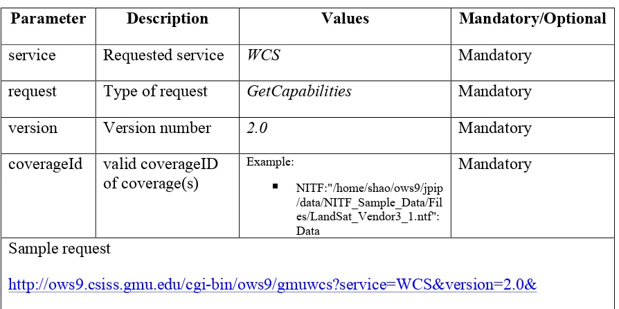
Annex B: Request parameters of GMLJP2 WCS
Table 1 GetCapabilities operation
Parameter Description Values Mandatory/Optional
service Requested service WCS Mandatory
request Type of request GetCapabilities Mandatory
version Version number 2.0 Mandatory
sections Comma-separated section names
ServiceIdentification ServiceProvider OperationsMetadata Contents
Optional
Sample request
http://ows9.csiss.gmu.edu/cgi-bin/ows9/gmuwcs?service=WCS&version=2.0&request=GetCapabilities
Table 2 DescribeCoverage operation
Parameter Description Values Mandatory/Optional
service Requested service WCS Mandatory
request Type of request GetCapabilities Mandatory
version Version number 2.0 Mandatory
coverageId valid coverageID of coverage(s)
Example:
NITF:"/home/shao/ows9/jpip /data/NITF_Sample_Data/Fil es/LandSat_Vendor3_1.ntf": Data
Mandatory
Sample request
http://ows9.csiss.gmu.edu/cgi-bin/ows9/gmuwcs?service=WCS&version=2.0&
OGC 12-155
Copyright © 2013 Open Geospatial Consortium. 13
NITF_Sample_Data/Files/Case1_HRE10G324642N1170747W_Uxx.hr5":Data
Table 3 GetCoverage operation
Param
eter Description Values
Mandator y/Optional
service Requested service WCS Mandatory
request Type of request GetCapabilities Mandatory
version Version number 2.0 Mandatory
coverag
subset Trimming and (or) slicing of coverage
OGC 12-155
14 Copyright © 2013 Open Geospatial Consortium.
interpol ation
interpolation method to be used
Examples:
nearest(default) bilinear cubic cubicspline lanczos
Optional
Sample request
http://ows9.csiss.gmu.edu/cgi-bin/ows9/gmuwcs?service=WCS&version=2.0&request=GetCoverage&coverageid=NIT F:"/home/yshao/ows9/jpip/data/NITF_Sample_Data/Files/Case1_HRE10G324642N1170 747W_Uxx.hr5":Data&format=image/jpeg2000&mediatype=multipart/mixed
OGC 12-155
Copyright © 2013 Open Geospatial Consortium. 15
Annex C: Request and response of GetCoverage for JPIP coverage
Request example:
http://ows9.csiss.gmu.edu/cgi-bin/ows9/gmuwcs?service=WCS&version=2.0&request=GetCoverage&coverageid=NIT F:%22/home/yshao/ows9/jpip/data/NITF_Sample_Data/Files/Case1_HRE10G324642N1 170747W_Uxx.hr5%22:Data&format=text/xml;urn:ogc:def:wcs:2.0:jpip-response
Response example:
<?xml version="1.0" encoding="UTF-8"?>
<Coverages xmlns="http://www.opengis.net/wcs/2.0"
xmlns:ows="http://www.opengis.net/ows"
xmlns:owcs="http://www.opengis.net/wcs/2.0/ows"
xmlns:xlink="http://www.w3.org/1999/xlink"
xmlns:xsi="http://www.w3.org/2001/XMLSchema-instance"
xsi:schemaLocation="http://schemas.opengis.net/ows/2.0 ../owsCoverages.xsd">
<Coverage>
<Abstract>JPIP (JPEG 2000 Interactive Protocol) is a compression streamlining protocol that works with JPEG 2000 to produce an image using the least bandwidth required. GMU CSISS developed JPIP-enabled GMLJP2 WCS service which could deliver the response of GetCoverage request in JPEG2000 format via JPIP protocol. The URL included in this XML could be opened by Kakadu JPIP client, LEADTOOLS JPIP Client or any other JPIP clients.
</Abstract>
<Reference
xlink:href="jpip://ows9.csiss.gmu.edu:9002/ows9cache/Case1_HRE10G324642N117074
7W_Uxx.20121003143311.jp2" xlink:role="urn:ogc:def:role:WCS:2.0:coverage"/>
OGC 12-155
16 Copyright © 2013 Open Geospatial Consortium.
Annex D: Tools to visualize JPIP stream
1. Kakadu Client
(1) Download the Kakadu Win32 Executables from here, and install them on your local computer.
(2) Send a GetCoverage request and specify the response format as JPIP protocol, then retrieve the JPIP URL from the response, as shown in Annex C.
(3) Open the executable program named kdu_show.exe, and click File -> Open JPIP URL. In the pop up window, specify the following values in the corresponding box:
Server: ows9.csiss.gmu.edu:9002
Transport protocol: http-tcp
Resource or request string: path of the output JPEG2000 data
OGC 12-155
Copyright © 2013 Open Geospatial Consortium. 17
(4) To check the metadata information, click Metadata -> Open Metadata. A window will be displayed, as seen in the following figure.