Open Geospatial Consortium
Approval Date: 2013-01-18 Posted Date: 2012-12-21 Publication Date: 2013-06-18
Reference number of this document: OGC 12-105
Reference URL for this document: http://www.opengisl.net/def/doc-type/per/ows9-ows-context
Category: Engineering Report
Editor: Joan Masó
OGC
®
OWS-9 - OWS Context evaluation IP Engineering
Report
Copyright © 2013 Open Geospatial Consortium.
To obtain additional rights of use, visit http://www.opengeospatial.org/legal/.
Warning
This document is not an OGC Standard. This document is an OGC Public
Engineering Report created as a deliverable in an OGC Interoperability Initiative
and is not an official position of the OGC membership. It is distributed for review
and comment. It is subject to change without notice and may not be referred to as
an OGC Standard. Further, any OGC Engineering Report should not be referenced
as required or mandatory technology in procurements
.
Document type:
OGC
®Engineering Report
Document subtype:
NA
Document stage:
Approved for public release
Abstract
This OGC Engineering Report describes the results of the OWS-9 IP on OWS Context
1.0. OWS Context is a draft OGC candidate standard. The OWS Context activity tested
and evaluated the relative benefits of different encoding methods prior to finalization of
the candidate standard. OWS Context has been proposed with an Atom encoding, a JSON
encoding and an HTML5 encoding. The encoding requirement seeks to understand the
level of mass-market acceptance of these different encoding options and their ability to
support mash-ups. Each encoding should be evaluated, including examples and
recommendations to move forward. Recommendations should enable the OWS Context
capability for OGC services while remaining cognizant of implementations using
mass-market technologies.
Keywords
ogcdoc, OGC document, context, ows context, json, atom, wmc, wmts
What is OGC Web Services 9 (OWS-9)?
OWS-9 builds on the outcomes of prior OGC interoperability initiatives and is organized
around the following threads:
-
Aviation
: Develop and demonstrate the use of the Aeronautical Information Exchange
Model (AIXM) and the Weather Exchange Model (WXXM) in an OGC Web Services
environment, focusing on support for several Single European Sky ATM Research
(SESAR) project requirements as well as FAA (US Federal Aviation Administration)
Aeronautical Information Management (AIM) and Aircraft Access to SWIM (System
Wide Information Management) (AAtS) requirements.
-
Cross-Community Interoperability (CCI)
: Build on the CCI work accomplished in
OWS–8 by increasing interoperability within communities sharing geospatial data,
focusing on semantic mediation, query results delivery, data provenance and quality and
Single Point of Entry Global Gazetteer.
-
Security and Services Interoperability (SSI)
: Investigate 5 main activities: Security
Management, OGC Geography Markup Language (GML) Encoding Standard
Application Schema UGAS (UML to GML Application Schema) Updates, Web Services
Façade, Reference Architecture Profiling, and Bulk Data Transfer.
-
OWS Innovations
: Explore topics that represent either new areas of work for the
Consortium (such as GPS and Mobile Applications), a desire for new approaches to
existing technologies to solve new challenges (such as the OGC Web Coverage Service
(WCS) work), or some combination of the two.
implementing the following OGC standards: Web Map Service (WMS) 1.3 Interface
Standard, Web Feature Service (WFS) 2.0 Interface Standard, Geography Markup
Language (GML) 3.2.1 Encoding Standard, OWS Context 1.0 (candidate encoding
standard), Sensor Web Enablement (SWE) standards, Web Coverage Service for Earth
Observation (WCS-EO) 1.0 Interface Standard, and TEAM (Test, Evaluation, And
Measurement) Engine Capabilities.
The OWS-9 sponsors are
: AGC (Army Geospatial Center, US Army Corps of
License Agreement
Permission is hereby granted by the Open Geospatial Consortium, ("Licensor"), free of charge and subject to the terms set forth below, to any person obtaining a copy of this Intellectual Property and any associated documentation, to deal in the Intellectual Property without restriction (except as set forth below), including without limitation the rights to implement, use, copy, modify, merge, publish, distribute, and/or sublicense copies of the Intellectual Property, and to permit persons to whom the Intellectual Property is furnished to do so, provided that all copyright notices on the intellectual property are retained intact and that each person to whom the Intellectual Property is furnished agrees to the terms of this Agreement.
If you modify the Intellectual Property, all copies of the modified Intellectual Property must include, in addition to the above copyright notice, a notice that the Intellectual Property includes modifications that have not been approved or adopted by LICENSOR. THIS LICENSE IS A COPYRIGHT LICENSE ONLY, AND DOES NOT CONVEY ANY RIGHTS UNDER ANY PATENTS THAT MAY BE IN FORCE ANYWHERE IN THE WORLD.
THE INTELLECTUAL PROPERTY IS PROVIDED "AS IS", WITHOUT WARRANTY OF ANY KIND, EXPRESS OR IMPLIED, INCLUDING BUT NOT LIMITED TO THE WARRANTIES OF MERCHANTABILITY, FITNESS FOR A PARTICULAR PURPOSE, AND NONINFRINGEMENT OF THIRD PARTY RIGHTS. THE COPYRIGHT HOLDER OR HOLDERS INCLUDED IN THIS NOTICE DO NOT WARRANT THAT THE FUNCTIONS CONTAINED IN THE INTELLECTUAL PROPERTY WILL MEET YOUR REQUIREMENTS OR THAT THE OPERATION OF THE INTELLECTUAL PROPERTY WILL BE
UNINTERRUPTED OR ERROR FREE. ANY USE OF THE INTELLECTUAL PROPERTY SHALL BE MADE ENTIRELY AT THE USER’S OWN RISK. IN NO EVENT SHALL THE COPYRIGHT HOLDER OR ANY CONTRIBUTOR OF
INTELLECTUAL PROPERTY RIGHTS TO THE INTELLECTUAL PROPERTY BE LIABLE FOR ANY CLAIM, OR ANY DIRECT, SPECIAL, INDIRECT OR CONSEQUENTIAL DAMAGES, OR ANY DAMAGES WHATSOEVER RESULTING FROM ANY ALLEGED INFRINGEMENT OR ANY LOSS OF USE, DATA OR PROFITS, WHETHER IN AN ACTION OF CONTRACT, NEGLIGENCE OR UNDER ANY OTHER LEGAL THEORY, ARISING OUT OF OR IN CONNECTION WITH THE IMPLEMENTATION, USE, COMMERCIALIZATION OR PERFORMANCE OF THIS INTELLECTUAL PROPERTY. This license is effective until terminated. You may terminate it at any time by destroying the Intellectual Property together with all copies in any form. The license will also terminate if you fail to comply with any term or condition of this Agreement. Except as provided in the following sentence, no such termination of this license shall require the termination of any third party end-user sublicense to the Intellectual Property which is in force as of the date of notice of such termination. In addition, should the Intellectual Property, or the operation of the Intellectual Property, infringe, or in LICENSOR’s sole opinion be likely to infringe, any patent, copyright, trademark or other right of a third party, you agree that LICENSOR, in its sole discretion, may terminate this license without any compensation or liability to you, your licensees or any other party. You agree upon termination of any kind to destroy or cause to be destroyed the Intellectual Property together with all copies in any form, whether held by you or by any third party. Except as contained in this notice, the name of LICENSOR or of any other holder of a copyright in all or part of the Intellectual Property shall not be used in advertising or otherwise to promote the sale, use or other dealings in this Intellectual Property without prior written authorization of LICENSOR or such copyright holder. LICENSOR is and shall at all times be the sole entity that may authorize you or any third party to use certification marks, trademarks or other special designations to indicate compliance with any LICENSOR standards or specifications.
This Agreement is governed by the laws of the Commonwealth of Massachusetts. The application to this Agreement of the United Nations Convention on Contracts for the International Sale of Goods is hereby expressly excluded. In the event any provision of this Agreement shall be deemed unenforceable, void or invalid, such provision shall be modified so as to make it valid and enforceable, and as so modified the entire Agreement shall remain in full force and effect. No decision, action or inaction by LICENSOR shall be construed to be a waiver of any rights or remedies available to it.
Contents
Page
1
Introduction ... 1
1.1
Scope ... 1
1.2
Document contributor contact points ... 1
1.3
Revision history ... 1
1.4
Future work ... 1
1.5
Forward ... 2
2
References ... 2
3
Terms and definitions ... 2
4
Conventions ... 3
4.1
Abbreviated terms ... 3
4.2
XML schema location ... 3
4.3
Used parts of other documents ... 3
4.4
Data dictionary tables ... 3
5
OWS context evaluation ER overview ... 5
6
Context Model ... 5
6.1
WMC Conceptual Model ... 5
6.2
OWS Context Conceptual Model ... 9
6.3
Comparison between WMC and OWS Context ... 14
6.4
Preformatted service requests ... 17
6.4.1
The case of the WMTS standard ... 18
6.5
Inclusion of direct content ... 22
6.5.1
Inclusion of direct content in the OWS Context scenarios ... 23
6.6
Pixel coordinates versus CRS coordinates ... 24
6.6.1
Width and height ... 25
6.6.2
scaleDenominator ... 26
6.7
Resource ordering and grouping ... 26
6.7.1
Resource displaying ordering ... 26
6.7.2
Resource grouping ... 26
6.7.2.1
Resource tree ... 26
6.7.2.2
Resource folder ... 26
6.7.2.3
Resource themes ... 27
7
OWS Context Encodings ... 28
7.1
ATOM Encoding ... 28
7.1.1
ATOM encoding mapping ... 29
7.1.1.1
Adding geospatial extent to Atom ... 29
7.1.1.2
Adding geospatial content to Atom ... 30
7.1.1.3
Dublin Core namespace in atom ... 32
7.1.2
ATOM encoding validation ... 32
7.1.2.1
ATOM encoding validation using RelaxNG ... 32
7.1.2.2
ATOM encoding validation using W3C schemas and schematon ... 33
7.1.3
ATOM examples ... 46
7.1.3.1
ATOM offering content example ... 46
7.1.3.2
ATOM WMS offerings ... 49
7.2
JSON encoding ... 50
7.2.1
Avoiding XML AJAX cross domain vulnerability restriction using
CORS ... 51
7.2.2
JSON encoding schemas ... 51
7.3
HTML5 encoding ... 51
7.3.1
HTML5 canvas encoding ... 52
7.3.2
HTML5 inline SVG encoding ... 52
7.3.3
Geolocation API ... 53
7.4
How to develop extensions ... 54
7.4.1
OWS context package example ... 54
8
ATOM encoded OWS Context implementations in clients ... 66
8.1
ATOM encoded OWS Context in browsers ... 66
8.2
ATOM encoded OWS Context in Mass Market applications ... 67
8.3
ATOM encoded OWS Context visualization with XSLT ... 68
8.3.1
Transform a OWS Context document into a overlaped view using
XSLT ... 68
8.4
ATOM encoded OWS Context in a JavaScript smart clients ... 73
8.5
ATOM encoded OWS Context in a desktop implementations. ... 74
8.6
Transform a WMC document into an OWS Context document. ... 74
8.7
Transform a WMS/WFS capabilities document into an OWS Context
document ... 75
9
ATOM encoded OWS Context implementations in services ... 82
9.1
OWS Context CSW server ... 83
9.1.1
CSW extension for OWS Context ... 83
9.1.2
OWS Context WPS usecase ... 89
10
Future work ... 89
10.1
Annotations ... 89
10.2
ServiceMetadata documents and OWS Context convergence ... 94
10.3
GeoPackage manifest and OWS Context convergence ... 95
10.4
Packed OWSContext file ... 95
10.5
JSON encoding ... 95
10.6
HTML5 ... 96
10.7
Relations between schemas problem ... 96
10.7.1
GML profiles and GeoRSS ... 96
Figures
Page
Figure 1 — Interpretation of a feed reader with geospatial information in content by the
Opera Web Browser ... 31
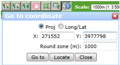
Figure 2 — Button “Locate” implements the javascript getCurrentPosition() function and
return a value in the Barcelona Region ... 54
Figure 3 — OWS Context document presented in Internet Explorer and Opera ... 66
Figure 4 — OWS Context document presented in the four more common browsers with
Atom support. ... 67
Figure 5 — OWS Context document presented in Google maps ... 67
Figure 6 — OWS Context document presented in Bing maps My places. ... 68
Figure 7 — OWS Context document translated to HTML just using XLST. ... 73
Figure 8 — A map browser build with JavaScript is presenting a context document for
content selection. ... 73
Figure 9 — A MiraMon GIS pro presenting the content of a context document. ... 74
Figure 10 — Transformation between a WFS Capabilities document and a OWS Context
done in OWS9. ... 75
Figure 11 — Imagery Annotation Use Cases ... 90
Figure 12 — A conceptual graphic showing his thinking on how annotation fits with other
standards (generated by Raj Singh) ... 90
Figure 13 — Annotation elements in an example. ... 92
Tables
Page
Table 1 — Contents of data dictionary tables ... 4
Table 2 — WMC General model ... 5
Table 3 – WMC:Layer ... 6
Table 4 — OWC:Context ... 9
Table 5 — OWC:Resource ... 10
Table 6 — Definitions of owc:Offering elements ... 12
Table 7 — Definitions of owc:Operation elements ... 13
Table 8 — Definitions of owc:Content elements ... 13
Table 9 — Comparison between OWC:Context and WMC general information ... 14
Table 10 — Comparison between OWC Resource and WMC layer information ... 15
Table 11 — Current browsers support for Atom ... 66
OGC
®
OWS-9 - OWS Context evaluation IP Engineering
Report
1
Introduction
1.1
Scope
This OGC
®document gives guidelines for using different encodings for OWS Context
1.0. It also summarizes lessons learned in the OGC OWS-9 when working with an OWS
Context document. It covers 2 encodings i.e. ATOM and JSON, and it discusses how
OWS Context can be used in an HTML5 application.
This OGC
®document is applicable to clients and servers that are capable of reading or
writing an OWS Context.
1.2
Document contributor contact points
All questions regarding this document should be directed to the editor or the contributors:
Name Organization
Joan Masó CREAF
1.3
Revision history
Date Release Editor Primary clauses
modified
Description
2012-08-25 1 Joan Masó First draft to present in OWS-9
2013-01-07 2 Joan Masó First official version presented on pending documents.
1.4
Future work
The main issue is about having a clear recommendation on how to include annotations in
OWS Context and fix some schema validation problems that appear when trying to use
GML profiles such as GeoRSS simultaneously with WFS.
1.5
Forward
Attention is drawn to the possibility that some of the elements of this document may be
the subject of patent rights. The Open Geospatial Consortium shall not be held
responsible for identifying any or all such patent rights.
Recipients of this document are requested to submit, with their comments, notification of
any relevant patent claims or other intellectual property rights of which they may be
aware that might be infringed by any implementation of the standard set forth in this
document, and to provide supporting documentation.
2
References
The following documents are referenced in this document. For dated references,
subsequent amendments to, or revisions of, any of these publications do not apply. For
undated references, the latest edition of the normative document referred to applies.
OGC 12-080
OGC
®OGC OWS Context Standard. Conceptual Model
OGC 12-084
OGC
®OWS Context Standard. ATOM Encoding
In addition to this document, this report includes several XML Schema Document files as
specified in Annex A.
3
Terms and definitions
For the purposes of this report, the definitions specified in Clause 4 of the OWS Common
Implementation Standard [OGC 06-121r3], the OGC OWS Context Conceptual Model
[OGC 080] and the OGC OWS Context ATOM Encoding Specification [OGC
12-084] shall apply. In addition, the following terms and definitions apply.
3.1
annotation
Any marking on illustrative material for the purpose of clarification.
[ISO19117:2005 "Protrayal"]
An association between an annotation entity (e.g. a text label) and an image or some
geometric “region” within the image.
An illustrative feature overlapped to a map and anchored to a geospatial feature, a part of
it or a spatial region for the purpose of clarification.
3.2
nominal scale denominator
Ratio between the size of a feature in CRS coordinates and the size of a feature in a
screen that has a pixel size of 0.28mm
4
Conventions
4.1
Abbreviated terms
Some frequently used abbreviated terms:
JSON: JavaScript Object Notation
OWS: Open Geospatial Web Services
OWC: OWS Context
4.2
XML schema location
Many XML fragments are included in this document and sometimes XML schema
locations are referenced. For convenience we work with local copies of the schemas
instead of pointing to the official OGC Schema repository (
http://schemas.opengis.net/
)
using full URLs (and avoid relative referencing between different namespaces). By doing
this we are ignoring an OGC recommendation. The reasons for doing so are that there is
no official OWS Context in the repository and that it is then possible to work offline.
Please, note that if you plan to copy some of the code included in this document you have
to modify the XML schema locations and point it to the official OGC repository.
4.3
Used parts of other documents
This document uses significant parts of document [OGC 12-080]. To reduce the need to
refer to that document, this document copies some of those parts with small
modifications. To indicate those parts to readers of this document, the largely copied
parts are shown with a light grey background (15%).
4.4
Data dictionary tables
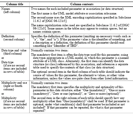
Table 1 — Contents of data dictionary tables
Column title
Column contents
Names
(left column)
Two names for each included parameter or association (or data structure).
The first name is the UML model attribute or association role name.
The second name uses the XML encoding capitalization specified in Subclause
11.6.2 of [OGC 06-121r3].
The name capitalization rules used are specified in Subclause 11.6.2 of [OGC
06-121r3]. Some names in the tables may appear to contain spaces, but no
names contain spaces.
Definition
(second column)
Specifies the definition of this parameter (omitting un-necessary words such as
“a”, “the”, and “is”). If the parameter value is the identifier of something, not
a description or a definition, the definition of this parameter should read
something like “Identifier of TBD”.
Data type and value
(third column)
or
Data type
(if are no second
items are included
in rows of table)
Normally contains two items:
The mandatory first item is often the data type used for this parameter, using
data types appropriate in a UML model, in which this parameter is a named
attribute of a UML class. Alternately, the first item can identify the data
structure (or class) referenced by this association, and references a separate
table used to specify the contents of that class (or data structure).
The optional second item in the third column of each table should indicate the
source of values for this parameter, the alternative values, or other value
information, unless the values are quite clear from other listed information.
Multiplicity and use
(right or fourth
column)
or
Multiplicity
(if are no second
items are included
in rows of table)
Normally contains two items:
The mandatory first item specifies the multiplicity and optionality of this
parameter in this data structure, either “One (mandatory)”, “One or more
(mandatory)”, “Zero or one (optional)”, or “Zero or more (optional)”.
The second item in the right column of each table should specify how any
multiplicity other than “One (mandatory)” shall be used. If that parameter is
optional, under what condition(s) shall that parameter be included or not
included? If that parameter can be repeated, for what is that parameter
repeated?
When the data type used for this parameter, in the third column of such a table, is an
enumeration or code list, all the values specified shall be listed, together with the
meaning of each value. When this information is extensive, these values and meanings
should be specified in a separate table that is referenced in the third column of this table
row.
5
OWS context evaluation ER overview
The specified OWS context evaluation ER addresses the OWS Context draft standard and
studies possible encodings, validation techniques and practical implementations tested in
OWS 9.
In 2005 OGC released a standard for sharing map compositions that linked to WMS maps
called Web Map Context (WMC). This standard defines an XML encoding for saving the
status (the context) of a WMS client, which later can be used to recover the saved status.
It is able to save WMS URL entry points, the parameters needed to obtain each layer on a
map composition as well as the size of the screen in pixels among other metadata. The
standard also suggested the possibility of saving references to these XML files in another
file that acts as a very simple catalogue of WMC documents.
Since the first version of the WMS, OGC Web Services (OWS) have been diversified and
several service standards are now available for different tasks. Some integrated clients are
able to dialog with some of these services and to present the data to the user. The
possibility to extent WMC to other services was noted while elaborating the WMC
specification and, in fact, some work was already done by some authors. WMC was
combined with Web Processing Services and Map Services, furthermore WMC was
extended to support WFS services in a previous OWS interoperability experiment.
Clause 6 of this document analyzes the conceptual model of the new OWS context and
summarizes the practical implications of some decisions took by the Standards Working
Group. Clause 7 describes the encodings for the OWS Context, paying particular
attention to the Atom encoding as a way to include geospatial content in an Atom file. In
Clause 8, it can be found the description of Atom encoding implementation in integrated
clients. Clause 9 describes the Atom encoding in services. Finally Clause 10 describes
future work.
6
Context Model
6.1
WMC Conceptual Model
There is no conceptual model described in the WMC 05-005 but we can easily generate it
from the XML encoding description, which is well defined in the WMC standard.
Table 2 — WMC General model
Name
Definition
Data type and value
Multiplicity
and use
version
The published specification
version number, contains
three positive integers,
separated by decimal
points, in the form “x.y.z”
Character String type,
not empty
One
Name
Definition
Data type and value
Multiplicity
and use
id
Unique Identifier assigned
to the Context document
URI
One
(mandatory)
title
A human readable title for
the Context document
Character String type,
not empty
One
(mandatory)
abstract
Description of the Context
document purpose or
content
Character String type,
not empty
Zero or one
(optional)
contactInformation
Contact information of the
creator of the Context
document
ContactInformationTy
pe type
Zero or one
(optional)
boundingBox
It represents the
geographic extent that
should
be presented by
the client
GM_Envelope, it
includes the CRS
One
(mandatory)
witdh
The size in pixels of the
map the Context
document describes
integer
Zero or one
(optional)
height
The size in pixels of the
map the Context
document describes
integer
Zero or one
(optional)
keyword
Keyword related to this
context document. Shall
support an optional
codelist parameter
Character String type,
not empty
Zero or more
(optional)
layer
The description of a
resource and its access
parameters and
configuration
dCharacter String type,
not empty
One or more
(mandatory)
logoURL
A reference to an image that
might be attached to the
Context document.
URI and image sizes
Zero or more
(optional)
descriptionURL
A URL reference to a
webpage which contains
relevant information to the
view.
URI
Zero or more
(optional)
extension
Any other element
e
n/a
Zero or more
(optional)
Table 3 – WMC:Layer
Name
Definition
Data type and
values
Name
Definition
Data type and
values
Multiplicity
and use
serverURL
The link to online resource
endpoint of the service
URI
One
(mandatory)
serviceType
The type of the service
according to OGC
interfaces
Character String
type, not
empty.
Examples are WMS,
WFS.
One
(mandatory)
serviceVersion
Version number of the
OGC interface
specification which
corresponds to the
service
Character String
type, not empty
One
(mandatory)
serviceTitle
The title of the service
(extracted from the
Capabilities by the
Context document
creator)
Character String
type, not empty
Zero or one
(optional)
name
The name of the selected
layer (extracted from
Capabilities by the
Context document
creator).
Character String
type, not empty
One
(mandatory)
title
The title of the selected
layer (extracted from
Capabilities by the
Context document
creator). This element is
required.
Character String
type, not empty
One
(mandatory)
abstract
The abstract of the selected
layer (extracted from
Capabilities by the
Context document
creator). This element is
optional.
Character String
type, not empty.
One
(mandatory)
SRS
Available SRS for the
enclosing layer.
Character String
type, not empty
aZero or more
(optional)
dimension
This element is defined in
the Web Map Service
specification [WMS]. One
more attribute is defined
to specify the current
Dimension constraint. The
attribute “current” defines
the Dimension that
must
be used to request this
layer.
Name
Definition
Data type and
values
Multiplicity
and use
dataURL
A link to an online resource
where data corresponding
to the layer can be found.
This element is optional.
URI
Zero or one
(optional)
format
Describe output image
formats for the Layer.
Character String
type, not empty
Format attribute is
“current” that
contains 1 if the
current image
format is selected.
One or more
(mandatory)
hidden
Indicates if the layer should
be hidden in the client
result map.
Boolean
One
(mandatory)
queryable
Indicates if the layer is set as
queryable
Boolean
One
(mandatory)
style
Available styles for this layer
using named style or SLD
Style type
Zero or more
(optional)
minScaleDenominator The minimum scale from
which this layer should be
displayed by a client
application.
Double
Zero or one
(optional)
maxScaleDenominator The minimum scale from
which this layer should be
displayed by a client
application.
Double
Zero or one
(optional)
metadataURL
A link to an online resource
where descriptive metadata
corresponding to the layer
can be found.
URI
Zero or more
(optional)
dextension
Any other element
n/a
Zero or more
(optional)
a
One of the listed SRS’s must be the SRS mentioned in the ViewerContext/General/BoundingBox@SRS element.
Additionally, the WMC defines a ViewContextCollection that represent a list of context
documents. Context collections could be used in several ways:
A particular Viewer Client could use a Collection to construct a menu of default
start-up views.
A Collection of related contexts could serve as a script for a demonstration.
It has a version number and a list of ViewContextReference each one with its
corresponding id, title and contextURL to a context document.
6.2
OWS Context Conceptual Model
This clause discusses the conceptual model for OWS Context as it was at the moment of
writing this document. It is included here because it is foreseen that the model may
undergo some change in the future, during the later stages of the standards elaboration
process in OGC.
Mainly an OWC:Context element is a collection of general metadata for the context
document and a list of resources.
Table 4 — OWC:Context
Name
Definition
Data type and value
Multiplicity
and use
specReference
Specification Reference
(requirements class)
identifying that it is an
OWC Context document
and its version.
URI
Value SHALL be
“http://www.opengis.
net/spec/owc/1.0/req/
atom” in this version
One
(mandatory)
language
Language used in the OWC
Context document
Character String type,
not empty
One
(mandatory)
id
Unique Identifier assigned
to the OWS Context
document
URI
One
(mandatory)
title
A human readable title for
the OWS Context
Document
Character String type,
not empty
One
(mandatory)
abstract
Description of the Context
document purpose or
content
Character String type,
not empty
Zero or one
(optional)
updateDate
A date of a creation or
update of the Context
document
Date type
One
(mandatory)
author
An entity primarily
responsible for making the
Context document
Character String type,
not empty
Zero or one
(optional)
publisher
Identifier for the publisher
of the Context document
Character String type,
not empty
Zero or one
(optional)
creatorApplication
The tool/application used to
create the Context
document
Character String type,
not empty
Zero or one
(optional)
rights
Information about rights
held in and over the
Context document
Character String type,
not empty
Name
Definition
Data type and value
Multiplicity
and use
areaOfInterest
Geographic Area of interest
of the users of the Context
document
a bGM_Envelope
Zero or one
(optional)
timeIntervalOfInterest
A date or range of dates
relevant to the resource
TM_GeometricPrimiti
ve
Zero or one
(optional)
keyword
Keyword related to this
context document. Shall
support an optional
codelist parameter
Character String type,
not empty
Zero or more
(optional)
resource
The description of a
resource and its access
parameters and
configuration
dowc:Resource (as
defined in Table 5)
Zero or more
(optional)
contextMetadata
Additional metadata
describing the context
document itself. The
format recommended is
ISO19115 complaint
metadata. The metadata
standard used should be
specified
n/a
Zero or more
(optional)
cextension
Any other element
e
n/a
Zero or more
(optional)
a These properties define the geographic area of interest and date/time interval of interest to the contextuser. They do not define the bounding extent (either in geographic area or time) of the referenced resources. The intention is not to provide the overall bounds or clipping extent, but simply to indicate the accessor the expected view of the information in area and time.
b The Coordinate Reference System shall be unambiguous. It should either be implicitly indicated in the
choice of encoding of AOI or explicitly defined.
c
The rights described apply to the context document itself not to any of its contents.
d
Resources are ordered. Clients would normally interpret this in terms of display order. How the encoding defines the order of layers in relation to the display shall be defined in the encoding specification.
e Any encoding should allow the user to extend the Context content to include custom items.
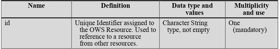
Mainly a OWC:Resource element is a collection of general metadata for the resource and
a list of offerings.
Table 5 — OWC:Resource
Name
Definition
Data type and
values
Multiplicity
and use
id
Unique Identifier assigned to
the OWS Resource. Used to
reference to a resource
from other resources.
Character String
type, not empty
One
Name
Definition
Data type and
values
Multiplicity
and use
title
A human readable title for
the OWC Resource.
Character String
type, not empty
One
(mandatory)
abstract
Description of the OWC
Resource Purpose or
Content.
Character String
type, not empty.
One
(mandatory)
updateDate
Date when the resource
definition was last updated.
Date type
One
(mandatory)
author
Identifier of the author of the
resource definition.
Character String
type, not empty
Zero or more
(optional)
apublisher
Identifier of the publisher of
the ows:resource.
Character String
type, not empty
Zero or one
(optional)
rights
Information about rights held
in and over the
ows:resource.
aCharacter String
type, not empty
Zero or one
(optional)
geospatialExtent
The spatial extent or scope of
the content of the
ows:resource.
bGM_Envelope
Zero or one
(optional)
temporalExtent
A date or range of dates
relevant to the
ows:resource.
TM_GeometricPrimi
tive
Zero or more
(optional)
preview
URI pointing to a quick-look
or browse image
representing the
ows:resource.
URI
Zero or more
(optional).
contentByRef
A URI identifying a service
which will return an
immediately exploitable
result by simply sending
requests based on the URI
for the ows:resource. The
expectation is that the
return type of this call will
be in a well-known format.
URI
Zero or more
(optional)
offering
Service or inline content
offered by the
ows:resource.
owc:OfferingType,
see Table 6
Zero or more
(optional)
active
This flag indicates the state
of the resource within the
context document. It can be
interpreted by the caller as
required (this may be
defined in a profile or in the
specific service extensions).
cBoolean
Default value is
TRUE
Zero or one
(optional)
keyword
Keyword related to this
ows:resource definition.
Shall support an optional
codelist parameter.
Character String
type, not empty.
Name
Definition
Data type and
values
Multiplicity
and use
minScaleDenominator Minimum scale for the
display of the ows:resource.
dDouble
Zero or one
(optional)
maxScaleDenominator Maximum scale for the
display of the ows:resource.
dDouble
Zero or one
(optional)
resourceMetadata
Metadata about the
ows:resource itself.
n/a
Zero or more
(optional)
dfolder
Definition of the folder
structure in which the
resource is placed.
CharacterString
Zero or one
(optional)
extension
Any other element
n/a
Zero or more
(optional)
aThe semantics of rights is not defined here and needs to be defined in extension packages.
b
The geospatial extent indicates a client that data intersecting with this area needs to be retrieved and ,if relevant portrayed. There is no specific requirement to hard clip the data to this boundary.
c
The temporal extent indicates a client that data intersecting with this time interval needs to be retrieved and if relevant portrayed. There is no specific requirement to hard clip the data to this boundary.
d
The scale denominator is defined with respect to a "standardized rendering pixel size" of 0.28 mm × 0.28 mm (millimeters). The definition is the same used in WMS 1.3.0 [OGC 06-042] and in Symbology
Encoding Implementation Specification 1.1.0 [05-077r4]. Frequently, the true pixel size is unknown and 0.28 mm is a common actual size for current displays.
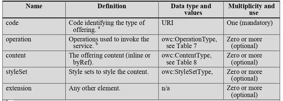
An OWC:Offering element can be a list mixing: OWS service operations, inline content
and “by reference” content.
Table 6 — Definitions of owc:Offering elements
Name
Definition
Data type and
values
Multiplicity and
use
code
Code identifying the type of
offering.
aURI
One (mandatory)
operation
Operations used to invoke the
service.
bowc:OperationType,
see Table 7
Zero or more
(optional)
content
The offering content (inline or
byRef).
owc:ContentType,
see Table 8
Zero or more
(optional)
styleSet
Style sets to style the content.
owc:StyleSetType,
Zero or more
(optional)
extension
Any other element.
n/a
Zero or more
(optional)
aOperations of an specific service request are defined in a separate extension of this document.
An OWS:Operation contains both how to request information to the OWS service and
eventually holds a container for the result of the operation.
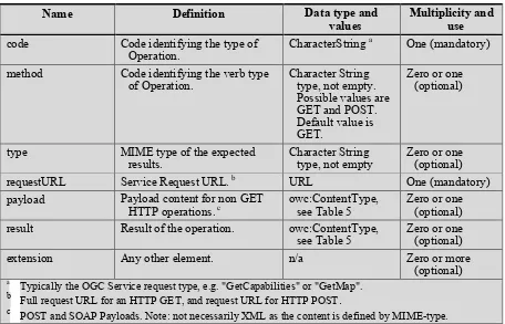
Table 7 — Definitions of owc:Operation elements
Name
Definition
Data type and
values
Multiplicity and
use
code
Code identifying the type of
Operation.
CharacterString
aOne (mandatory)
method
Code identifying the verb type
of Operation.
Character String
type, not empty.
Possible values are
GET and POST.
Default value is
GET.
type, not empty
Zero or one
(optional)
requestURL
Service Request URL.
bURL
One (mandatory)
payload
Payload content for non GET
HTTP operations.
cowc:ContentType,
see Table 5
Zero or one
(optional)
result
Result of the operation.
owc:ContentType,
see Table 5
Zero or one
(optional)
extension
Any other element.
n/a
Zero or more
(optional)
aTypically the OGC Service request type, e.g. "GetCapabilities" or "GetMap". b
Full request URL for an HTTP GET, and request URL for HTTP POST
.
cPOST and SOAP Payloads. Note: not necessarily XML as the content is defined by MIME-type.
The OWS:Content element is a container for direct content or OWS service results that
supports both inline or “by reference” content.
Table 8 — Definitions of owc:Content elements
Name
Definition
Data type and
values
Multiplicity and
use
type
MIME type of the Content.
CharacterString not
empty
One (mandatory)
URL
Referenced Content.
URL
Zero or one
(optional)
acontent
Inline content in the Content
element.
Any
Zero or one
(optional)
aextension
Any other element
n/a
One (mandatory)
a
6.3
Comparison between WMC and OWS Context
The following table compares the general information that is present in the OWS context
document. When a cell in the first column is blank, it means that no correspondence has
been found in OWC for an element present in WMC. When a cell in the second column is
blank, it means that no correspondence has been found in WMC for an element present in
OWC.
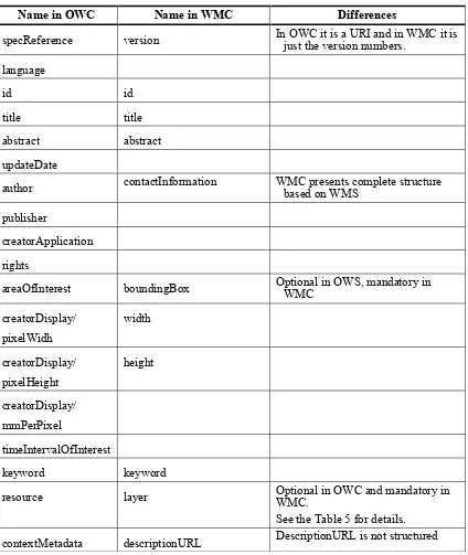
Table 9 — Comparison between OWC:Context and WMC general information
Name in OWC
Name in WMC
Differences
specReference
version
In OWC it is a URI and in WMC it is
just the version numbers.
language
id
id
title
title
abstract
abstract
updateDate
author
contactInformation
WMC presents complete structure
based on WMS
publisher
creatorApplication
rights
areaOfInterest
boundingBox
Optional in OWS, mandatory in
WMC
creatorDisplay/
pixelWidh
width
creatorDisplay/
pixelHeight
height
creatorDisplay/
mmPerPixel
timeIntervalOfInterest
keyword
keyword
resource
layer
Optional in OWC and mandatory in
WMC.
See the Table 5 for details.
Name in OWC
Name in WMC
Differences
information.
extension
extension
WMC was designed to support WMS services, even when the aim was to leave it open to
other standards in the future. The introduction of OGC 05-005 states that “Presently,
context documents are primarily designed for WMS bindings. However, extensibility is
envisioned for binding to other services”. That is not the case of the OWS Context, which is
designed to support any OWS service and from its origins it is meant to describe how to deal
with several services in small extensions.
It is not clear if the WMC was originally designed with other that KVP binding in mind.
Even if it does not talk about bindings, the fact that provides all the needed information to
build a request to a server (except the binding) without having to read the Capabilities
document, it suggest that the authors supposed a KVP binding. On the contrary, OWS
Context is designed to support KVP, XML SOAP binding and even some REST interfaces
(at least the WMTS one).
An important difference between WMC and OWC is that WMC provides a set of parameter
values and expects that the service will be able to construct the WMS request in the following
form:
{serverURL}?SERVICE={serviceType}&VERSION={serviceVersion}&LAYERS={na
me}&SRS={SRS}&BBOX={BoundingBox}&{DimensionName}={DimensionCurrentV
alue}...&FORMAT={currentFormat}&STYLES={StyleName}
You can read more about this topic in subclause
6.4 Preformatted service requests
Another important addition to OWC is the possibility to include geospatial content (data)
that can be embedded directly inline or referenced in a URL. You can read more about
this topic in subclause
6.5 Inclusion of direct content
The following table compares the specific information of each resource in OWS context
document and WMC.
Table 10 — Comparison between OWC Resource and WMC layer information
OWC Reosurce
WMC layer
Observations
id
title
title
abstract
abstract
OWC Reosurce
WMC layer
Observations
geospatialExtent
Assumed to be the general
BoundingBox
DataURL
OWC conceptual model do not
mention the possibility but Atom
encoding support it natively
contentByRef
offering
Composed using serverURL,
serviceType,
serviceVersion, name,
BoundingBox, SRS,
Dimension, format, Style
An offering has to be build in
WMC combining information.
active
Not
hidden
In OWS is optional and default is
TRUE. In WMC is mandatory
Existence of an
offering with and
operation that has a
code GetFeatureInfo
queryable
Inside the requestURL
or the payload of an
operation (in an
offering element)
that has a code
GetMap
name
in OWC it has to be parsed from a
requestURL layers= or in a XML
payload
Inside the requestURL
of an operation (in an
Inside the requestURL
or the payload of an
operation (in an
offering element)
that has a GetMap
code.
SRS
In WMC it is a list of possible
SRS’s.
Inside the requestURL
or the payload of an
operation (in an
offering element)
that has a GetMap
code.
Dimension
In WMC it is a list of a complex
type describing the dimensions
and their possible parameters.
The type or the
operation (in an
offering element)
that has a GetMap
code.
Format
In WMC it is a list of a complex
OWC Reosurce
WMC layer
Observations
keyword
minScaleDenominator Minimum scale for the
display of the ows:resource
d.
maxScaleDenominator Maximum scale for the
display of the ows:resource
d.
resourceMetadata
metadataURLextension
extension
OWC does not define anything like a ViewContextCollection but nothing prevents an
application to provide a list of context document as a web page or as any other means.
6.4
Preformatted service requests
There are 2 possible alternatives for referencing an OGC service from the OWS Context
document:
a)
Reference the endpoint as an entry and some parameters as other elements, leaving
some things open for the client to set.
b)
Reference a complete service request (full URL) in a way that the client only has to
sent it and wait for the data.
The alternative “a” was the one used in WMC. It assumes that the client knows how to
build a service request from its pieces and eventually add what it is missing (such as the
bounding box). It also assumes that the client will allow some “dynamic” interaction with
the user that will be able to change the state of the view. This implies that the client will
be able to modify the needed parameters and resubmit queries. The alternative “b”
assumes that some clients will not be knowledgeable enough to formulate a request. This
is a reasonable assumption if you are targeting more standard services types than WMC.
OWS Context standard uses alternative ‘b’ (which provides the exact URL of a complete
request inside the requestURL or the payload of an operation (in an offering element).
This decision has two main advantages:
Simple clients are able to requests the offerings URL, then they just wait for the
results and later present them, all of these without needing any knowledge on how
to build requests (nor the details of each service and version) for all the possible
web services included in the atom document. Just knowing the MIMEtype that
will be returned is enough as long as the client knows how to show this
If the client knows how to deal with embedded GML, it automatically supports
WFS requests and WPS requests that return GML.
In fact there is an alternative “c” that is between both alternatives “a” and “b”.
c)
Reference a service request that still has some parameters to resolve in the form of a
URL template. The client needs to substitute the still-to-resolve variables in the URL
template to be able to get the information from the server, so the client becomes more
dependent on particularities of each service supported.
The URL template language proposed here is standardized in the RFC6570 standard.
6.4.1
The case of the WMTS standard
As previously exposed, the alternative “a” is used in the WMC standard. Unfortunately,
this standard only deals with WMS services (and it was developed before the WMTS was
designed). WMC has an extensibility mechanism that could be used to adapt WMC to
any other OGC standard. This could be particularly easy with WMTS due to that WMS
and WMTS share many parameter names and meanings. This will not be explained
because it is out of the scope of this deliverable.
As mentioned earlier, the alternative “b” requires to provide all the requests needed to fill
a bounding box of a chosen scale. This is an example that shows how a WMTS offering
could look like:
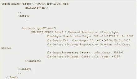
<feed xmlns="http://www.w3.org/2005/Atom" xml:lang='en'>
... <entry>
<owc:offering
code="http://www.opengis.net/spec/owc/1.0/conf/atom/wmts">
<owc:operation code="GetCapabilities" method="GET" type="application/xml"
href="http://www.opengis.uab.es/SITiled/ICC/1.0.0/WMTSCapabilities.xml"/> <owc:operation code="GetTile" method="GET" type="image/jpeg"
href="http://www.opengis.uab.es/SITiled/ICC/Topo250k_Vers5_ICC/default/Cat_topo 250k_v5_EPSG23031/200m/1/0.jpg"/>
<owc:operation code="GetTile" method="GET" type="image/jpeg"
href="http://www.opengis.uab.es/SITiled/ICC/Topo250k_Vers5_ICC/default/Cat_topo 250k_v5_EPSG23031/200m/1/1.jpg"/>
<owc:operation code="GetTile" method="GET" type="image/jpeg"
<owc:operation code="GetTile" method="GET" type="image/jpeg"
href="http://www.opengis.uab.es/SITiled/ICC/Topo250k_Vers5_ICC/default/Cat_topo 250k_v5_EPSG23031/200m/2/1.jpg"/>
</owc:offering> <entry>
This approach has several problems.
The context document is supposed to be client independent and thus it can’t be
tied to a particular width and height of the screen. The issue is that the client is
supposing some screen size when it chooses the tiles that are going to be included
in the context documents.
We are providing several URLs for tiles without any information about how they
have to be arranged in the space. This implies that the client has to read the
TileMatrixSet structure stored in the GetCapabilities document, and then
interpreted the URLs to finally associate a bounding box to each tile. The client
will then calculate the needed tile position in the screen as well as the cutting
needed in the borders of the viewport. This is as complicated as creating the
URLs based on the service entry point in the client side.
There are two alternatives to solve this:
Alternative b.1: The context document includes some information that explains
how to distribute each tile in the screen (in screen coordinates) to the client. We
propose to have top and left parameters that include (the screen coordinates, in
pixels) the origin of the top/left corner of the image in the viewport. If the
numbers are negative, it means that the top/left corner of the image starts outside
of the viewport and should be cut by the client. By also providing the width and
height of the image, the client can know if the bottom/right corner is also outside
of the viewport and then cut the part that lies outside.
<feed xmlns="http://www.w3.org/2005/Atom" xml:lang='en'>
... <entry>
<owc:offering
code="http://www.opengis.net/spec/owc/1.0/conf/atom/wmts">
<owc:operation code="GetCapabilities" method="GET" type="application/xml"
href="http://www.opengis.uab.es/SITiled/ICC/1.0.0/WMTSCapabilities.xml"/> <owc:operation code="GetTile" method="GET" type="image/jpeg" width="640" height="480" top="-185" left="-485"
<owc:operation code="GetTile" method="GET" type="image/jpeg" width="640" height="480" top="-185" left="155"
href="http://www.opengis.uab.es/SITiled/ICC/Topo250k_Vers5_ICC/default/Cat_topo 250k_v5_EPSG23031/200m/1/1.jpg"/>
<owc:operation code="GetTile" method="GET" type="image/jpeg" width="640" height="480" top="295" left="-485"
href="http://www.opengis.uab.es/SITiled/ICC/Topo250k_Vers5_ICC/default/Cat_topo 250k_v5_EPSG23031/200m/2/0.jpg"/>
<owc:operation code="GetTile" method="GET" type="image/jpeg" width="640" height="480" top="295" left="155"
href="http://www.opengis.uab.es/SITiled/ICC/Topo250k_Vers5_ICC/default/Cat_topo 250k_v5_EPSG23031/200m/2/1.jpg"/>
</owc:offering> <entry>
Alternative b.2: The context document includes information that explains how to
distribute each tile in the screen in CRS coordinates to the client. We propose to
have a top , left, bottom and right parameters (or a bbox parameter) that include
the CRS coordinates of the origin of the top/left and the bottom/right corners of
the image. By combining this information with the nominal scaleDenominator of
the view and the bounding box of the view, the client can calculate the exact
position of each tile in the viewport. No pixel coordinate parameters are needed in
this approach.
<feed xmlns="http://www.w3.org/2005/Atom" xml:lang='en'>
... <entry>
<owc:offering
code="http://www.opengis.net/spec/owc/1.0/conf/atom/wmts">
<owc:operation code="GetCapabilities" method="GET" type="application/xml"
href="http://www.opengis.uab.es/SITiled/ICC/1.0.0/WMTSCapabilities.xml"/> <owc:operation code="GetTile" method="GET"
type="image/jpeg" left="258007" top="4655992" right="386007" bottom="4559992" href="http://www.opengis.uab.es/SITiled/ICC/Topo250k_Vers5_ICC/default/Cat_topo 250k_v5_EPSG23031/200m/1/0.jpg"/>
<owc:operation code="GetTile" method="GET"
type="image/jpeg" left="386007" top="4655992" right="514007" bottom="4559992" href="http://www.opengis.uab.es/SITiled/ICC/Topo250k_Vers5_ICC/default/Cat_topo 250k_v5_EPSG23031/200m/1/1.jpg"/>
<owc:operation code="GetTile" method="GET"
href="http://www.opengis.uab.es/SITiled/ICC/Topo250k_Vers5_ICC/default/Cat_topo 250k_v5_EPSG23031/200m/2/0.jpg"/>
<owc:operation code="GetTile" method="GET"
type="image/jpeg" left="386007" top="4559992" right="514007" bottom="4463992" href="http://www.opengis.uab.es/SITiled/ICC/Topo250k_Vers5_ICC/default/Cat_topo 250k_v5_EPSG23031/200m/2/1.jpg"/>
</owc:offering> <entry>
In the alternative “c”, we are not going to provide a list of complete tile URLs but a URL
template for the WMTS requests, this will leave the client to find how many URLs he
needs to fill the display window and where it has to put it. This excludes simple clients
that are geo-enable but do not know about the particularities of each standard. It is
suggested to use the URL template approach described in the RESTful approach of
WMTS but replacing all the variables by their concrete values except the {TileRow} and
{TileCol} ones.
<feed xmlns="http://www.w3.org/2005/Atom" xml:lang='en'>
... <entry>
<owc:offering
code="http://www.opengis.net/spec/owc/1.0/conf/atom/wmts">
<owc:operation code="GetCapabilities" method="GET" type="application/xml"
href="http://www.opengis.uab.es/SITiled/ICC/1.0.0/WMTSCapabilities.xml"/> <owc:operation code="GetTile" method="GET" type="image/jpeg"
href="http://www.opengis.uab.es/SITiled/ICC/Topo250k_Vers5_ICC/default/Cat_topo 250k_v5_EPSG23031/200m/{TileRow}/{TileCol}.jpg"/>
</owc:offering> <entry>
Note that even if the URL template has not been described for the KVP syntax, it is still
possible to express it as KVP syntax in a URL template (as it is done in RESTful syntax)
as shown in the following example:
<feed xmlns="http://www.w3.org/2005/Atom" xml:lang='en'>
... <entry>
<owc:offering
<owc:operation code="GetCapabilities" method="GET" type="application/xml"
href="http://www.opengis.uab.es/SITiled/ICC/1.0.0/WMTSCapabilities.xml"/> <owc:operation code="GetTile" method="GET" type="image/jpeg"
href=”http://www.opengis.uab.es/cgi-bin/MiraMon.cgi?service=WMTS&request=GetTile&version=1.0.0&layer=Topo250k_Vers5 _ICC2&style=default&format=image/jpeg&TileMatrixSet=Cat_topo250k_v5_EPSG23031&T ileMatrix=200m&TileRow={TileRow}&TileCol={TileCol}"/>
</owc:offering> <entry>
A similar template trick could be applied to generalize the template solution with the
SOAP approach.
The authors of this ER recommend the alternative “b.1”.
6.5
Inclusion of direct content
One of the benefits of the OWS Context is the capability to also to connect to direct
content, i.e. data files.
The mechanism is implemented by the current ows:content element that allows both
in-line (embedded) content and by-reference content (linked content) but not both (see Table
8).
Example of in-line content:
<owc:content type="application/gml+xml">
<my_srf:RoadCollection xsi:schemaLocation="http://www.opengis.net/gml/3.2 http://www.opengis.net/gml/3.2.1/gml.xsd
http://www.opengis.net/owc/1.0/examples/example1 SpringRoadField.xsd" xmlns:gml=" http://www.opengis.net/gml/3.2 "
xmlns:my_srf=" http://www.opengis.net/owc/1.0/examples/example1 " gml:id="ID_ROADS1">
<my_srf:road>
<my_srf:Road gml:id="ID_ROAD1"> <my_srf:position
<gml:LineString gml:id="ID_LINEROAD1"> <gml:pos>300 200</gml:pos>
<gml:pos>350 222</gml:pos> </gml:LineString
</my_srf:position>