The application of fractal geometry analysis
to groundwater exploration
Sari B. KUSUMAYUDHA
Geology Department, Faculty of Mineral Technology, Research Institute, UPN "Veteran", Jl. SWK 104 Condongcatur,Yogyakarta 55283, Indonesia, [email protected]
ABSTRACT: “Fractal” is a geometry that is specified by a non-integer number of scaling system called fractal dimension. In this study, fractal geometry analysis was applied to unravel groundwater exploration problems in the Gunungsewu Hills and the Progo Dome, Central Java, Indonesia. The Gunungsewu Hills is a karstic terrain with conduits, dolines, caves, and subterraneous rivers, while the Progo Dome is a volcanic landform with intensive joint dissections, low permeability fractured aquifer, complex groundwater flow type, and various phreatic water levels. In the Gunungsewu Hills, fractal analysis was utilized to determine the existence of underground flow system. Based on the distribution of fractal dimensions of the fracture patterns, Gunungsewu Area can be divided into three units with different fractal dimensions, i.e. Unit A with fractal simension 0.000 < D < 1.099, Unit B with fractal dimension 1.100 < Ds < 1.299, and Unit C with fractal dimension 1.300 < D < 1.460. Underground flow systems generally occur in Unit C. In the Progo Dome fractal analysis was used to delineate the locations of groundwater discharge. The area can be divided into four zones with different fractal dimensions, i.e. Zone A with fractal dimension D <1.409, Zone B with fractal dimension 1.410 > D >1.609, Zone C with fractal dimension 1.610 > D > 1.809, and Zone D with fractal dimension D > 1.810. The most potential division where to find spring is the zone with fractal dimension 1.410 - 1.609.
Key words: fractal, irregularity, karstic aquifer, fractured aquifer
1. INTRODUCTION
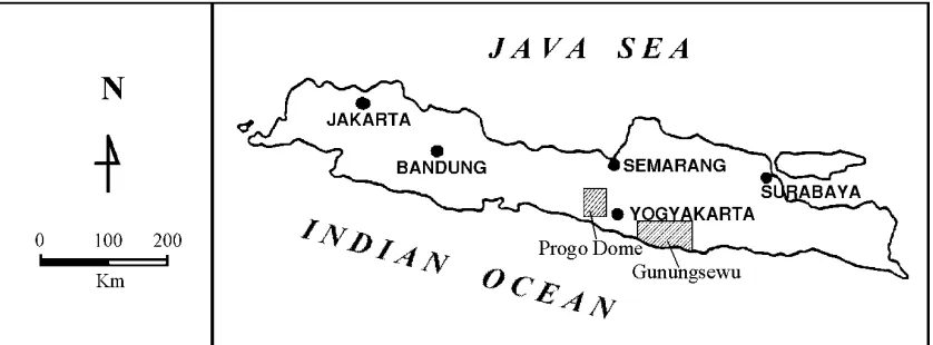
This paper reveals a study of groundwater exploration in unique hydrogeologic systems. Gunungsewu and Progo Dome are two areas in theYogyakarta Special Territory, Indonesia, which always suffer from fresh water problems especially in the dry season. Gunungsewu is a cone-karst-hills area, situated in the south of Yogyakarta City, while
Progo Dome is predominantly composed of hard - jointed volcanic rocks, located in the west. Fig 1 shows the locations of the study areas. Although the average annual precipitation in both areas is about 2500 mm or higher, they are always subjected to water deficiency.
irregular, and unique hydrogeologic system, where conventional methods were not adequate to be applied.
Approaches used in this study were fractal geometry analyses. The reason of using this, is because fractal geometry affects hydrogeological processes at all scales. It also has been invoked to model pore size distributions, relative permeability, the stockes flow in conduits with fractal perimeter, and the relation of flow permeability and microstructures (Adler, 1996).
(Figure 1)
2. REVIEW OF FRACTAL GEOMETRY
Mandelbrot (1983) used fractal terminology for determining non-Euclidean objects, which have non-integer dimension. It is formed from a simple shape, which grows more complex as the shape is repeated in miniature around the edges of the first shape (Xie 1993). Smaller versions of the shape grow out these smaller shapes, and so on to infinitive scale, to result an infinite, swirling, and complex shape.
Fractal scaling system is specified by non-integer numbers so called fractal dimension (Bunde & Havlin, 1994). Determination of fractal dimension is very important in dealing with practical quantification problems, because it generally correlated to origin or process acting on the fractal object (Kusumayudha, et. al., 19971). Fractal dimension is also a value that reflects the irregularity degree of fractal geometry (Sukmono, 1996) .
The fractal natures are self-similarity, self-affinity, self-inverse, and self-squaring (Peitgen, et.al. 1992). It is also important to refer that, the part of the set is the small scale of the entire fractal set. These characteristics enable fractals to unravel a natural object into its primitive elements.
There are several methods to determine a fractal dimension, e.g. the similarity method, the cantor dust method, the balls covering method, the sandbox method, and the box counting method (Mandelbrot 1983). The method used in this study is box-counting, because it is simple and easy to perform. This method is done by drawing grids with certain length side (r) over the fractal object. Then the fractal dimension (D) is determined using derive the fractal dimension, e.g., the slope of the plot (Tricot 1996).
3 HYDROGEOLOGY OF THE
GUNUNGSEWU HILLS
Dip of stratification in the Gunungsewu area is regionally southward. A syncline is in the center part of the area with a northeast trending axis. Fig. 2 demonstrates the geological condition of the Gunungsewu Hills. There are two facies constituting the Wonosari Formation, i.e. bioclastic and reefs.
Physical performances of the limestones are massive, hard, but cavernous, called karstified limestone, and brittle and soft, called chalky/calichified limestone (Kusumayudha, et.al, 19972). Karstified limestones develop karstic aquifer, while calichified limestones (caliche) perform non-karstic aquifer. Non karstic aquifers are only found locally with minor distribution, and commonly trap water as a perched layer. The karstic limestone is perforated by conduits and cavity openings, while the caliche (chalky limestone) is pored by matrix porosity. Therefore the water movement in karstified limestone is of conduit flow type, while in calichified limestone it is of diffuse flow type.
In the northern part, where bioclastic
limestones occur, the water table is 5 – 10 m deep, whereas in the south, which is underlain by reef limestones, the depth of water table increases abruptly to 150 m or more. Areas of shallow groundwater and areas of deep groundwater in the study area are separated by faults that strike northwest-southeast and northeast-southwest, which act as seals.
There are several surface flows that sink underground and water discharges through coastal springs or outlets to the Indian Ocean. Discharges of the largest outlet ranges from 4000 to 21000 L/sec (Kusumayudha, et.al., 2000).
(Figure 2)
4. DETERMINING UNDERGROUND
FLOW IN THE GUNUNGSEWU HILLS
The development of secondary porosity in karstic formations is lead by rock
stratification, joints, and faults. Geometrically, fracture structures especially joint patterns in various scale is fractal (Korvin, 1992). Three hundred (300) strikes of fracture structures including faults, joints and cracks in the Gunungsewu area, statistically show northwest-southeast and northeast-southwest orientations.
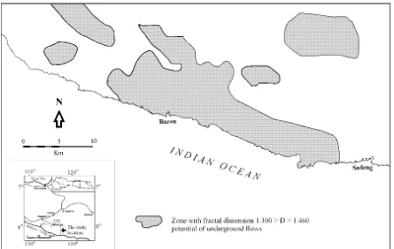
It is assumed that by knowing the structure patterns, the development of subsurface channels and their general flow directions can be identified. Precise identification needs quantitative analysis. Therefore the fracture patterns need to be examined quantitatively using their fractal dimensions. To derive the fractal dimension of fracture structures, 2 x 2 km2 grids are drawn on the base map of the study area. Then the crack lineaments that exist in each box of the grid are analyzed. Result of this analysis demonstrates that the pattern of fracture structures in the study area can be divided into three units with different fractal dimensions. They are Unit A, with fractal dimension 0.000 < D < 1.099, Unit B, with fractal dimension 1.100 < D < 1.299, and Unit C, with fractal dimension 1.300 < D. < 1.460 (Fig.3).
Cave water flows in the study area statistically show three directions, i.e.
southwestward, southeastward, and
is potential to the existance of underground flow nets (Fig. 4).
(Figure 3 and Figure 4)
The existence of underground channel patterns in Serpeng and Baron had been detected using geo-electric method.
5. HYDROGEOLOGY OF THE PROGO DOME
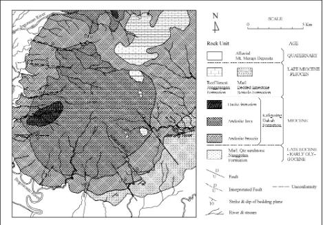
Progo Dome is a Tertiary Volcanic Complex Region. The stratigraphy is composed of marl sandstone, claystone, and tuff of the Nanggulan Formation, andesitic breccias, agglomerate, lava, and lapilli tuff of Kaligesing-Dukuh Formation, reef limestones of Jonggrangan Formation, marl and bedded limestone of Sentolo Formation, and Quaternary Deposits, respectively. Quaternary Deposits consist of gravel, granule, sand, laharic breccias and fine grained pyroclastics of Mt. Merapi. Joints and relatively radial faults, as shown in the geologic map of Fig. 5, intensively dissect the Progo Dome.
The potential water-bearing formation discussed in this paper is the Kaligesing-Dukuh Formation, although its overall permeability appears to be low. Due to its compositions, and the intensive joint dissection, this formation belongs to a fractured volcanic aquifer (Kusumayudha & Pratiknyo, 2001). In the hydrogeologic system, marl of Nanggulan Formation acts as impermeable bed-layer. The aquifer is totally unconfined. There are several water discharges trough crack systems with rate less than 100 L/sec.
(Figure 5)
6. DELINEATING ZONE OF DISCHARGE IN THE PROGO DOME
Similar to the Gunungsewu Area, air photos 1: 50000 scale have been used to trace and analyze the fissure networks of the Progo
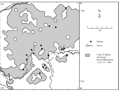
Dome. The map was grided by 1 x 1 km. Then the fractal dimension of joint network in each box of the grids was determined. Result of analysis in this study is a map showing the distribution of fractal dimensions of fracture systems in the Progo Dome Area. From this map, it can be delineated four zones with different fractal dimension each, i.e. Zone A with fractal dimension D < 1.409, Zone B with fractal dimension 1.410 > D >1.609, Zone C withfractal dimension 1.610 > D > 1.809, and Zone D with fractal dimension D > 1.810. The zone of discharge based on fractal analysis is shown in Fig. 6.
There are ten identified springs, 5 springs are situated in Zone B, and 5 springs are in Zone C. In order to validate the fractal analysis method to determine discharge locations, field checking was done, and nine more springs were discovered. All these new springs are located in Zone B. From these data, it can be denoted that the locations of springs in Kulonprogo Area are in the zones with fracture fractal dimension of 1.410 to 1.809. But the most potential is the area with fractal dimension of 1.410 - 1.609. Therefore it can be concluded that Zone B is the most potential for discharge, and recommended as the first priority zone where to find springs (Fig. 7).
(Figure 6, Figure 7)
7. CONCLUSIONS
From these analyses it can be concluded that: 1) The Gunungsewu area can be divided into
three units with different fractal dimensions of fracture pattern. They are Unit A, 0,000 < D < 1.099, Unit B, 1.100 < D < 1.299, and Unit C, 1.300 < D < 1.460. The zone where subsurface flow system potential to occur is Unit C with fractal dimension 1.300 - 1.460.
dimension 1.410 >D>1.609, Zone C with identify the occurrence of subsurface flow system in Gunungsewu, and the occurrence of discharges in a volcanic fractured aquifer in the Progo Dome.
8. REFERENCES
Adler, P.M., 1996. Transport in fractal porous media: Journal of Hydrology, v. 187, pp 195-213
Bunde, A. & S. Havlin, 1994. Fractals in Science: Springer Verlag
Korvin, G., 1992. Fractal Models in the Earth Science: Elsevier Publishers
Kusumayudha, S., M.T.Zen, S.Notosiswoyo, and R.S.Gautama, 19971. Identification of fractal pattern of underground river and surface topography in the Gunungsewu Area, Proc. PIT HAGI XXII.
--- 19972. Study of carbonate distribution based on fractal characteristic of valley pattern and secondary porosity, case:
Paliyan Area and sorrounding,
Gunungkidul, DIY, Jurnal Teknologi
--- 2000. Groundwater potency of the Wonosari-Baron Hydrogeologc
Sub-system 1998-1999 Proc PIT IAGI XXX, pp 73 - 84
Kusumayudha, S.B. & P. Pratiknyo, 2001. Detecting the existence of groundwater discharge in the fractured volcanic area, Majalah Geologi Indonesia, Vol 16 No 2, p 83 - 91 Applications of fractal geometry to porous media: a review: SPE 20476
Suyoto, 1994. Stratigraphic sequence of the Gunungsewu carbonate, Proc. PIT IAGI XXIII, Vol 1, pp 67-76.
White, W.B., 1988. Geomorphology and hydrology of karst terranes: Oxford University Press, New York
Fig. 1. The location of the study area
Fig. 3. Map showing the zonations of fracture patterns in the Gunungsewu area
Fig.6. Zonation of the fractal dimensions of fracture patterns