International Journal of Hydrology Science
and Technology
2018 Vol. 8 No. 2
Pages
Title and authors
105-119
Surfing safe waves: integration of water quality modelling in the evaluation of
potential health risks
Rita Marteleira; Pedro Bicudo; António Guerreiro De Brito; Pedro Santos Coelho
DOI:
10.1504/IJHST.2018.10011524
120-133
Mahbub Hasan; Aschalew Kassu; Srinivasa Rao Mentreddy
DOI:
10.1504/IJHST.2018.10011528
175-189
Solar photocatalytic detoxification using immobilised titanium oxide: a
cost-effective tertiary treatment method for decentralised wastewater effluents
Mohammed Matouq; Daed Dabbas; Bassim Abbassi
DOI:
10.1504/IJHST.2018.10011529
190-208
Treatment of world's largest and extensively hydrocarbon polluted
environment: experimental approach and feasibility analysis
Yohannes Yihdego; Radwan A. Al-Weshah
Keywords: fractured aquifer system; surface flow; tunnel inflow; mining problem; Indonesia.
Reference to this paper should be made as follows: Kusumayudha, S.B., Pratiknyo, P., Purwanto, Riswandi, H., Ciptahening, A.N. and Hermawanti, N. (2018) ‘Fissure structure analysis to unravel groundwater inflow problem in gold mining site of Pongkor area, West Java, Indonesia’, Int. J. Hydrology
Science and Technology, Vol. 8, No. 2, pp.148–162.
Biographical notes: Sari Bahagiarti Kusumayudha is a Professor of Hydrogeology at the Geological Engineering Department, Faculty of Mineral Technology, UPN ‘Veteran’ Yogyakarta. She made many publications related to the field of hydrogeology, karst hydrogeology, engineering geology and geological disasters in various conferences, scientific journals both in Indonesia and international. Some popular scientific books and reference books on fractal analysis for hydrogeologic exploration, fractal analysis for earthquake and tsunami mitigation, hydrogeology, karst hydrogeology, surface water, active volcanoes, and Merapi Volcano of Indonesia have also been written by her. Puji Pratiknyo is a Lecturer and Researcher in the Geological Engineering Department Faculty of Mineral Technology, UPN ‘Veteran’ Yogyakarta in the field of hydrogeology. He is actively doing research and community services especially in the field of hydrogeology. His publications are especially related to hydrogeology science and technology.
Purwanto is a Lecturer and Researcher at the Geological Engineering Department, Faculty of Mineral Technology, UPN ‘Veteran’ Yogyakarta in the field of engineering geology. His research activities are especially related to geotechnical engineering, exploration geology, and hydrogeology. Currently, he is pursuing further studies for doctoral program in engineering geology. Herry Riswandi is a Lecturer and Researcher in the Geological Engineering Department, Faculty of Mineral Technology, UPN ‘Veteran’ Yogyakarta. His field of study is hydrogeology and geological exploration. He is active in doing research in the field of hydrogeology and geological exploration. Currently, he has advanced his study for doctoral program in hydrogeology.
Ayu Narwastu Ciptahening is a Teaching Staff and Research Assistant at the Disaster Management Study Program, Environmental Engineering Department, Faculty of Mineral Technology, UPN ‘Veteran’ Yogyakarta. She made lots of research activities and community services in the field of engineering geology, geotechnical engineering, geological exploration for avalanches, dams, and disaster management. She also actively participates in various seminars and workshops on engineering geology and disaster risk reduction.
1 Introduction
In the Pongkor area, Bogor regency, West Java province, Java Island, Indonesia, there is a gold mining, operated by applying underground excavation system. There is a huge potential quartz vein containing gold ores, namely Vein Ciurug that is one of the main sources of the gold mining. Unfortunately, such a hydrogeological problem occurred in the tunnel environment, disrupting subsurface engineering construction, and inhibiting mineral exploitation activities. According to Sudharto et al. (2010), at the time of tunnel construction to take the ore, there was water flowing out from such a water saturated zone. When the ramp at elevation +484 m asl was advanced to cross cut Vein Ciurug, before reaching the vein, the drilling penetrated a water saturated zone, which then a large amount of groundwater ingress to the tunnel (Gautama et al., 2010). Furthermore, static groundwater flow floods the ramp down about 350 m long with water level +499 m asl, causing problems in mining activities at the site under +500 m asl (Gautama et al., 2010).
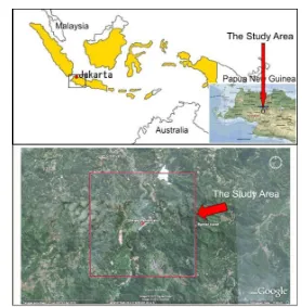
Figure 1 Location map of the study area, Bogor regency, West Java, Indonesia (see online version for colours)
area was not evaluated yet, and countermeasures to solve the problem were not well formulated.
Due to the rationales mentioned above, such more detail and different way of assessment than have been done before to overcome the problems is needed to be held, in order the mining activity can be operated as expectation. This study was done to assess the hydrogeological condition, determine the sources of groundwater inflow, and find problem solution for the gold mining activity, by applying fissure/fracture structure analysis. Location of the study was in Pongkor and surrounding area, Bogor regency, West Java province, Indonesia, with the coordinates of UTM Zone 48, 670,800–674,800 mE and 9,260,400–9,264,400 mN. Figure 1 shows the location map of the study area. The target of the study is to produce hydrogeologic map, conceptual model, and matrix of recommendation to unravel the hydrologic problem.
2 Method of study
Basically, this study was conducted by analytical assessment using secondary and primary data, compiled with some field works, such as surveys, observations, and mappings. Remote sensing by satellite imagery interpretation was also done in early step of the field works, especially to get initial information on geological structures, and especially general fracture pattern of the study area. Surface geological mapping was performed by utilising basic topographic map of 1:25,000 scale. Hydrogeologic mapping was conducted based on the previous map developed by Murtianto (2008). Refers to Brassington (2007), petrologic laboratory analysis, river flow rate measurements, surface water infiltration measurements using doble ring infiltrometer, and chemistry laboratory testings to acquire rock and water properties were done, and used for supporting hydrogeologic system identification (Domenico and Schwartz, 1990; Fetter, 1994).
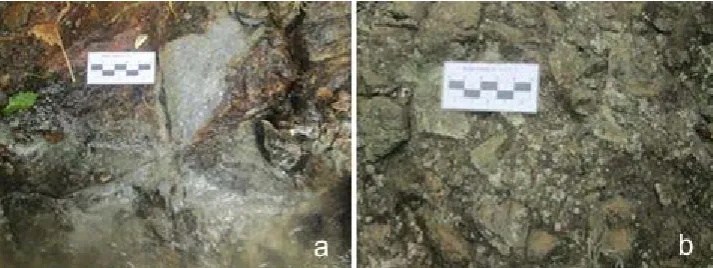
Figure 2 Volcanic rocks in the study area, (a) pyroclastic breccia (b) autoclastic breccia (see online version for colours)
therefore fissure analysis was absolutely needed to be applied. The analysis was completed by tracing the lineament of joints, cracks, and fractures using air photo and satellite imagery, combined with fissure structures data directly got from field investigation, and then plotted into rosette diagram to get the general pattern of geological structures especially joint and fault system. Joint spacing computation and analysis was also done, used to determine the aquifer characteristic in the study area. As considerations in this study, Saha (2013) proposed such a numerical model to managing groundwater-surface water problems. While Allawi (2014) stated that problems related to flow through an unconfined aquifer resting on a semi pervious layer, must take the leakage factor of the semi pervious layer, the transmissivity and the specific yield of the aquifer as hydro-geological constants into account.
3 Results and discussion
3.1 Geology
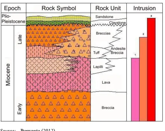
According to Van Bemmelen (1949), Pongkor and surrounding area belongs to the Banten Zone which is a part of the east wing of Bayah Mountains. The geomorphology can be classified as denudated volcanic hills (Van Zuidam, 1983), with some igneous rock intrusions. Purwanto and Riswandi (2008) and Riswandi and Purwanto (2008) stated that the geologic history of Banten Zone started with volcanism in the late Eocene to early Miocene, followed by volcanism in Pleistocene, creating such volcanic wavy landform and intrusion hills. The landform is eroded by streams of river Cikaniki and river Cimaja, developing a sub-dendritic pattern. Concerning to Basuki et al. (1994), Efendi et al. (1998), Purwanto and Riswandi (2008) and Purwanto (2012), rock units composing the regional stratigraphy of Bayah Zone from the oldest to the youngest formations can be broken down as follows (Figure 3):
1 Bayah formation consists of pebbly sandstone with clay stone interlayering and locally coal seam of about 3 m thick at the upper part, Oligocene aged, and unconformably overlain by Cijengkol formation.
2 Cijengkol formation consists of claystone and limestone of Oligo-Miocene, can be correlated to Batuasih formation and Rajamandala formation from the Bogor zone. 3 Cimapag formation consists of andesite breccias with some limestone fragments,
black clay layer of 15 cm thick from marine deposition. It is sedimented in early Miocene epoch.
4 Sareweh formation consists of claystone and limestone from shallow marine. 5 Bojongmanik formation consists of sandstone and claystone with coal insertion, of
middle Miocene.
6 Young volcanic deposits is the youngest rock unit in Banten zone, comprises acidic tuff from quaternary volcanic products of Pleistocene epoch.
In detail, the geological condition of Pongkor area is as expressed in the stratigraphic column set by Purwanto (2012) and the geologic map built by the authors (Figure 4)
Figure 3 The stratigraphy of Pongkor and surrounding area (see online version for colours)
Source: Purwanto (2012)
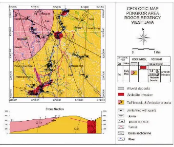
Stratigraphy of the study area is comprisedof four rock units including andesite breccia unit, tuff breccia unit, andesite intrusion, and alluvial deposits. Andesite breccia is composed of andesite fragments, pebble-gravel grain sized, sub angular to angular shaped of fragments, poorly sorted, open frabic, sand matrix, a little tuff content, and silica cement. This unit is presumed to belahar deposit. Tuff breccia unit is predominantly composed of andesite fragments, mixed with tuff and lapilli, sub angular shaped, poorly sorted, open fabric, sand matrix, silica cement, and pressumed to be pyroclastic flow deposits. Andesite intrusion as dike in the study area shows porphyritic texture, with hornblende, pyroxene, quartz, plagioclase, and K-feldspar composition. Alignment direction of the dike is northeast-southwest. In some outcrops, there is autobreccia structure, formed by the freezing process of magma at/or near the surface. Alluvial deposits consist of unconsolidated material of clay, silt, sand, gravels and boulders, sourced from the older rock formations.
Figure 4 Geologic map of Pongkor area (see online version for colours)
Table 1 Fault data in the study area
Name of the fault Strike and dip of the fault plane Relative movement
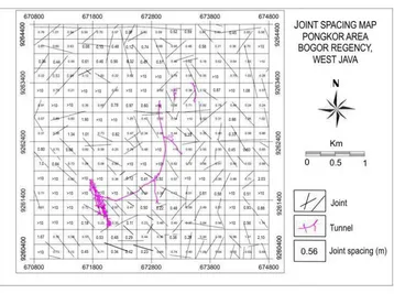
Figure 5 Map showing joint spacing (derived from satellite image) of the study area (see online version for colours)
3.2 Hydrogeologic condition
Based on hydrogeologic a property that is influenced by rock unit composition and geologic structure intensity, groundwater bearing formation in the study area can be classified into three types, namely: aquifer, aquitar and semi aquifuge. Considering to the kind of openings, which are predominantly formed by fissures, the aquifercan be categorised as fractured aquifer. It is composed of tuff breccias, andesitic breccias, and andesite, the joint spacing ranging 0.07–0.9, mostly located in the middle part, occupying 55% of the study area. Due to the rocks condition that is fractured, there exist such weak zones which function as the entry way of surface water into subsurface. In order to prove the influence of the geologic structures to hydrogeological condition of the study area, fracture density, orientation and pattern needs to be analysed.
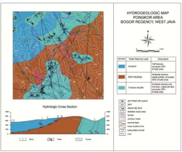
Aquitar consists of tuff breccia, tuff, and lapilli tuff, with joint spacing ranges 1.0–> 10 m. It occupies the western part, 20% of the total study area. Geologic structure such as fracture and fault in this unit is not well developed. On the other hand, semi aquifuge is specified by very small porosity and permeability, it stores and capables of passing a very little water to none at all (approaching akuifuge). The semi aquifuge consists of andesite breccia and andesite intrusion, with joint spacing of 1.0 –> 10. It is distributed in the western and eastern part, 25% of the total research area. Structures existing in the semi aquifuge are a rejoints but not so dense, locally, and do not show any systematic pattern. Hydrogeologic map of the study area is showed in Figure 7.
To complete the hydrogeological assessment in the study area, and in order to identify the quality, 51 water samples were taken from river and flows in the tunnel. They were in general colourless, odourless, and tasteless. The acidity was normal with pH around seven, based on the values of TDS and electric conductivity, the ground water can be classified into fresh water.
3.3 Surface flow and infiltration
Surface water system of river Cikaniki, river Cimaja and their tributaries form such watersheds. Flow direction of the main rivers is to the north, in general forming sub dendritic drainage patterns (Figure 8). It is influenced by the existence of joints and faults, in mature stadium. There are two watersheds namely Cikaniki watershed and Cimaja watershed. Streamflow measurements were done at 38 locations of river Cikaniki and its tributaries. The flow rate of river Cikaniki varies from 5.188 m3/sec to
32.88 m3/sec, while its tributaries range between 0.027 m3/sec and 0.193 m3/sec. The
flow rates of river Cikaniki and its tributaries show two different characters, the highest rate at the southern part is 32,88 m3/s, while the highest rate at the northern part is only
7,70 m3/s. Infiltration capacity based on measurements done at two locations of river
Cikaniki, recorded 1.2 m3/h and 0.2 m3/h. Infiltration rate in the study area is 14 cm/min
at the first location with a capacity of infiltration (F1) = 1.2 m3/h, and 3 cm/min at the
second location with a capacity infiltration (F1) = 0.2 m3/h. Flow measurements data of
River Cikaniki can be seen in Table 2.
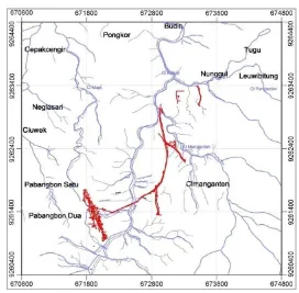
Figure 8 Drainage pattern of Pongkor area (see online version for colours)
Table 2 Flow rate measurements data of river Cikaniki
Site location Flow rate
(m3/s)
Site location Flow rate
(m3/s)
North part South part
Q16 7.70 Q2 10.04 Q18 7.00 Q5 30.38 Q19 6.18 Q6 32.88 Q22 5.74 Q13 11.37 Q23 7.35 Q14 14.01
3.4 Hydrogeologic conceptual model
As indicated by Chiu and Chia (2012), there can be an impact of groundwater discharge to such a tunnel penetrated a water source. In the study area, there is groundwater inflow to the tunnel through fissures system (Figure 9). Results of flow rate measurements on river Cikaniki and its tributaries around Vein Ciurug demonstrate two trends, i.e., in the north part the maximum flow rate is 7.70 m3/s, and in the south part the maximum flow
rate is32.88 m3/s. It reflects such a significant decrease of the flow rate of river Cikaniki
system before crosscutting the fault (38–48 m3/s) and after (20–27 m3/s). This condition
strengthens the assumption that there is such a leakage of river Cikaniki into the tunnel through fissure system, causing massive groundwater inflow to the ramp down at the elevation under +500 m asl, flooding the tunnel.
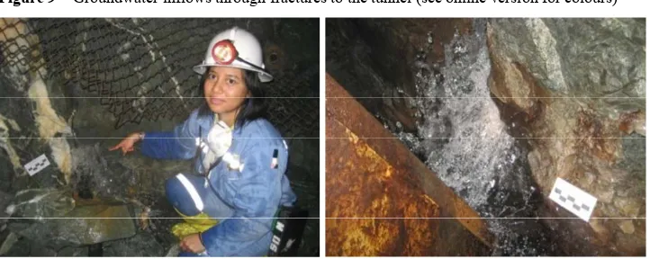
Figure 9 Groundwater inflows through fractures to the tunnel (see online version for colours)
Figure 10 Conceptual model of hydrogeological leakage from river Cikaniki to the tunnel (see online version for colours)
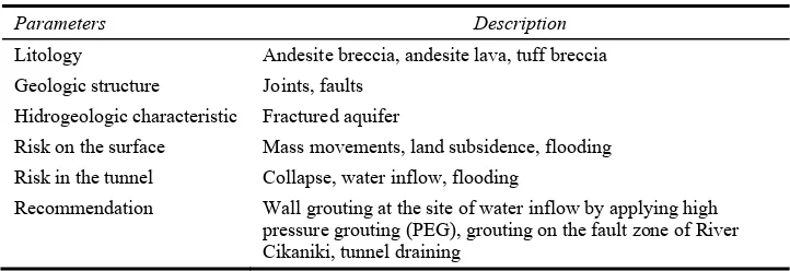
3.5 Recommendation of problem solving
Focusing on Cikaniki watershed, a matrix of risks and countermeasures related to hydrogeological problems in the mining tunnels was compiled. Parameters considered for the assessment include geological and hydrogeological factors (Ward and Trimble, 2004) that exist either on the surface or in the tunnel. The matrix of risk and problem solving of the Vein Ciurug and surrounding area is as follows (Table 3).
Table 3 Matrix of risk and problem-solving for the tunnel of Vein Ciurug
Parameters Description
Litology Andesite breccia, andesite lava, tuff breccia Geologic structure Joints, faults
Hidrogeologic characteristic Fractured aquifer
Risk on the surface Mass movements, land subsidence, flooding Risk in the tunnel Collapse, water inflow, flooding
Special wall grouting by pre-excavation grouting (PEG) method, using microfine cement (MC) supplemented with colloidal silica (CS) (Garshol et al., 2013) is need to be done on the fault zone in the tunnel of where the water inflow, and at the location of where river Cikaniki is crosscut by the fault. On the other hand, in order to drain the water that already flooding the tunnel, a draining system can be operated.
4 Conclusions
The study area geomorphologically expresses denudated volcanic hills with intrusion, and is drained by two major rivers, namely river Cikaniki and river Cimaja. The lithology is composed of andesite breccia, tuff breccia and andesite intrusion of Mioceneepoch. The area is strongly dissected by joints and faults, direction of the lineament pattern is generally north-northwest-south-southeast and north-northeast-south-southwest, and movement type of the main faults is lateral slip.
River Cikaniki showed flow rate of 32.88 m3/sec (maximum) and 0.01 m3/sec
(minimum). Infiltration ranged from 0.2 m3/h to 2.1 m3/h. Based on the values of EC,
TDS, and pH, the water quality can be categorised as fresh water.
Water bearing rocks in the study area can be classified into fractured aquifer, aquitar and semi aquifuge. The fractured aquifer comprises andesite breccia, the aquitar involves tuff breccia, while the semi aquifuge consists of andesite breccias and intrusive rock that are not intensively fractured. Water flow system in the aquifer occurs through fissures (joints and faults). Water supply of the aquifer is mainly derived from surface runoff, especially river Cikaniki. This is verified by the significant decrease in rate at the time before and after the river flowing across the fracture/fault zone system.
There is a leakage of river Cikaniki stream into the fracture scheme that cuts the tunnel, causing flooding in the tunnel. This problem disrupts mining activities at ramps with elevation lower than +500 metres above sea level. Recommendation to solve the problem is tunnel wall grouting on the site of groundwater inflow by high pressure grouting (PEG) method, grouting at the fault zone on the bottom of river Cikaniki stream, and draining system in the tunnel that is subjected to groundwater flooding.
Acknowledgements
References
Allawi, F. (2014) ‘Groundwater flow through an unconfined aquifer resting on a semi-pervious layer’, Int. J. of Hydrology Science and Technology, Vol. 4, No. 4, pp.336–347.
Basuki, A., Sumanagara, D.A. and Sinambela, D. (1994) ‘The Gunung Pongkor gold-silver deposit, West Java, Indonesia’, Journal of Geochemical Exploration, Vol. 50, Nos. 1–2, pp.371–391,
Elsevier Science.
Brassington, R. (2007) Field Hydrogeology, 3rd ed., John Wiley & Sons Ltd, London, England.
Chiu, Y. and Chia, Y. (2012) ‘The impact of groundwater discharge to the Hsueh-Shan tunnel on the water resources in northern Taiwan’, Hydrogeology Journal, Vol. 20, No. 8,
pp.1599–1611.
Domenico, P.A. and Schwartz, F.W. (1990) Physical and Chemical Hydrogeology, John Wiley &
Sons, New York, USA.
Efendi, A.C., Kusinama and Hermawanto, B. (1998) Geologic Map of Bogor Sheet, Java, Scale
1:100.000, Center of Geological Research and Development, Bandung, Indonesia.
Fetter, C.W. (1994) Applied Hydrogeology, 3rd ed., Macmillan College Publishing Company, New
York, USA.
Garshol, K.F., Tam, J.K.W., Mui, S.W.B., Chau, H.K.M. and Lau, K.C.K. (2013) ‘Deep subsea rock tunnels in Hong Kong’, Proc. World Tunnel Congress 2013, Geneva, Switzerland,
pp.1–7.
Gautama, R.S., Syafrizal, Nuhindro, P.W. (2010) Hydrogeologic Assessment of Ramp Down
Ciurug L450 in Gold Mining Business Unit, Pongkor (First Step), PT LAPI ITB, Bandung,
Indonesia.
Hernandez, J.J.C., Freyre, C., Martinez, M.C. and Levresse, G. (2016) ‘Groundwater flow in transboundary fault-dominated aquifer and the importance of regional modeling: the case of the city of Queretaro, Mexico’, Hydrogeology Journal, Vol. 24, No. 2, pp.373–393.
Murtianto, E. (2008) Hydrogeologic Map of Indonesia, Bogor Sheet, Scale 1:100.000, Directorate
of Environmental Geology, Bandung.
Petchsingto, T. and Karpyn, Z.T. (2010) ‘Simulation of fluid percolation in a rough-wallet rock fracture’, Hydrogeology Journal, Vol. 18, No. 2, pp.1583–1589.
Purwanto, H.S. (2012) ‘Structural control on gold mineralization of subsurface quartz veins of level 600 m–500 m in the gold mining, Pongkor, West Java’, Jurnal Ilmiah MTG, Vol. 5, No. 2,
pp.17–22, ISSN: 1979-0090.
Purwanto, H.S. and Riswandi, H. (2008) ‘Alteration & Mineralization of goldin Nirmala area, Bogor West Java’, Proc. Earth National Seminar 2008, Universitas Pembangunan Nasional
‘Veteran’ Yogyakarta.
Riswandi, H. and Purwanto, H.S. (2008) ‘Interpretation of structure and alteration zone based on geophysical interpretation in Nirmala area, Bogor West Java’, Scientific Journal MTG, Vol. 1,
No. 2, pp.21–26, Universitas Pembangunan Nasional ‘Veteran’ Yogyakarta, ISSN: 1979– 0090.
Robles, V.M. and Candela, L. (2010) Hydrological Conceptual Model Characterisation of an
Abandoned Mine Site in Semiarid Climate, Department of Geotechnical Engineering and
Geosciences, Technical University of Catalonia (UPC), Jordi Girona, Barcelona 08034, Spain. Saha, G.C. (2013) ‘Analysis of groundwater-surface water interaction in horizontal unconfined aquifer bounded by a stream and groundwater divide using a non-linear numerical model’, Int.
Sudharto, A., Risono, Purnama Y., Pratama, R. and Nugroho, I.I. (2010) ‘Determination ofsupplyzone of subsurface water inVein Ciurug ofunderground mining, UBPE – Pongkor PT ANTAM, Tbk’, Proc. Perhapi XiX Annual Convention & Exhibition, Balikpapan, pp.33–39.
Van Bemmelen, R.W. (1949) The Geology of Indonesia, Vol. IA, Martinus Nijhoff, The Hague.
Van Zuidam, R.A. (1983) Guide to Geomorphologic Aerial Photographic Interpretation and
Mapping, ITC Enschede, The Netherlands.