SPECTRAL CHARACTERISTICS OF HIGH-YIELDING VARIETIES OF
RICE PLANTS USING LANDSAT 8 DATA
Candra Dewi*), Ahmad Afif Supianto, Sutrisno
Program of Information Technology and Computer Science, Brawijaya University Jl. Veteran no. 8 Malang 65145 East Java Indonesia
*) Corresponding author Phone: +62-341- 577 911 Email: [email protected]
Received : June 12, 2013 /Accepted :September 29, 103
ABSTRACT
In applying remote sensing technology for inventory, evaluation and estimation of rice crop production, required the data of spectral characteristics changing of the plants during its growth phase. By identifying spectral characteristics, it will be recognized the objects in the images. This study identifies the spectral characteristics of high-yielding varieties of rice plants during their growth in Malang regency. Based on the results of field survey, the high yielding varieties that are commonly planted consist of IR64, Ciherang and Membramo. Then, from the identification of vegetation index is known thet al.,l these three varieties have different growth patterns, where the most distinct pattern found in IR64.
Key words: spectral characteristic, high-yielding varieties of rice, growth period of rice
INTRODUCTION
Rice is a staple food source in almost all regions of Indonesia. Therefore, the increasing of population resulted the increasing of the demand for rice. However, the extent of agricultural area more and more reduced and turned into residential area and other uses. Thus, continuos monitoring and identification of the rice plant are needed to determine the availability of rice. For this purposes, it is necessary to obtain the accurate data and information about the extent of agricultural area and harvest estimation.
One of the method that can be used to obtain the data and information is by using satellite image. Process of inventory, evaluation and estimation of crop production using satellite image require data of spectral characteristics changing of the plant during its growth phase. Due to this, some research on
monitoring crop growth have been carried out. Most of these research utilizes a medium resolution imagery such as NOAA-AVHRR and MODIS (Panigrahy et al., 1992, Xiao et al., 2005 , Wataru et al., 2006, Sun et al., 2009, Kim and Yeom, 2012) and RADARSAT (Ribbes and Toan, 1999 , Shao et al., 2001). In Indonesia, the prediction of the greenery rate of agricultural crops, especially rice has been conducted continuously by Space Agency (LAPAN) using NOAA and MODIS satellite imagery. But, for a small scale of agricultural land parcell, this image could not be used because in one pixel contains a variety information of land uses. This will reduce the accuracy of the identification process (Strahler et al., 2006).
According to this limitation of medium resolution imagery, some research is conducted by using Landsat ETM + (Uchida, 2010, Nuarsa et al.,
2011). This image with a resolution of 30 m could be used for small scale agricultural land parcel. ETM+ imagery also has a revisit time every 16 days, so that appropriate if it is used for monitoring the growth of rice that has a growth cicle between 110 to 125 days .
In the study was conducted by Nuarsa et al.
(2011) the spectral identification process was carried out on Ciherang varieties. As in Indonesia, the type of rice planted is vary widely. In East Java, especially in Malang district, a type of rice that are usually planted is high yielding varieties of rice. This varieties can be grown many times using the seed that produce from the previous harvest yield with good treatment. Each type of high yielding varieties has difference characteristics and difference growth cycle until harvest time. In addition, each type also has different yields product. According to the Center for Rice Research Bereau (BPPT, 2009), rice IR64 ages ranged from 110 to 120 days with average yield is 5 tons/ ha and can reach a maximum of 6. For Ciherang variety has a life cycle of 116 to 125 days with an average yield about 6 tons/ha and can
Accredited SK No.: 81/DIKTI/Kep/2011
reach a maximum of around 8 tons. While Membramo variety has a lifespan of 115 to 120 days with the average yield is 6.5 tons/ha.
As already known, that the Landsat 7 satellite was damaged since May 2003 and resulted the captured images that contain stripping data. This image causes the identification process does not produce optimum accuracy. To replace this satellite, in February 2013, NASA launched Landsat 8 with characteristics similar to the Landsat ETM+ in contextual of resolution, correction methods, and the characteristics of the sensor (http://landsat. usgs.gov). However, Landsat 8 has added characteristic as perfecting of Landsat ETM+ such as the number of bands, the lower range of the electromagnetic waves spectrum that can be captured by the sensor and 16 bit value range of each pixel. The increasing of quantification for each pixel will improve the ability to distinguish each interpreted object.
To determine the sufficiency of rice in more detail, needs a research to perform spectral identification of each varieties of rice plant. Therefore, this study is aimed to identify the spectral characteristics of several varieties of rice plant using Landsat 8 image data. Identification was also performed to determine the age of the plant during it growth.
MATERIALSANDMETHODS
Study Area
Location of study is Malang regency. Administratively, the area is part of East Java
province, Indonesia. Geofigureically, the study area is located between 7o50 ' – 8o09 ' South Latitude and 112o33 ' – 112o44 ' East Longitude.
Rice plant phase consists of three phases namely vegetative (early growth until panicle formation/primordial), reproductive (primordial until flowering) and maturation (flowering to mature grain). In general, most tropical rice varieties have reproductive phase of approximately 35 days and a maturation phase of approximately 30 days.
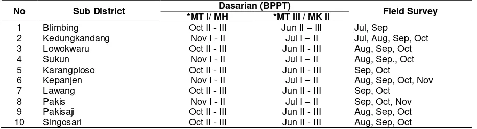
According to the Center for Agricultural Research and Development of Agriculture Ministry (CARD), the rice planting follows certain patterns season called dasarian. The dasarian is calendar system for rice cultivating established by the Ministry of Agriculture. However, based on the data obtained from the field survey, the majority of agricultural areas have cultivating time that does not comply with this calendar system. The field survey found that the average rice cultivating season is twice a year with each planting cycle was about 4 months (120 days). In addition, there are alternating cultivation system where is after rice planting then will be planted non-rice (such as corn and vegetables), and after that will be planted rice again. In some areas were found that in the adjacent areas there are differences rice planting season. We also found that the early planting time is difference between the field survey data and the data from BPPT (Table 1). From the field survey is also known the high-yielding varieties which are widely grown in Malang are IR64, Membramo and Ciherang.
Table 1. Rice cultivating season at some sub district in Malang (Source: BPPT, Agricultural Ministry and filed survey)
No Sub District Dasarian (BPPT) Field Survey
*MT I/ MH *MT III / MK II
1 Blimbing Oct II - III Jun II – III Jul, Sep
2 Kedungkandang Nov I - II Jul I – II Jul, Aug, Sep, Oct 3 Lowokwaru Oct II - III Jun II - III Aug, Sep, Oct
4 Sukun Nov I - II Jul I – II Aug, Sep., Oct
5 Karangploso Oct II - III Jun II - III Sep, Oct
6 Kepanjen Nov I - II Jul I – II Aug, Sep, Oct, Nov
7 Lawang Oct II - III Jun II - III Sep, Oct
8 Pakis Nov I - II Jul I – II Sep, Oct, Nov
9 Pakisaji Oct II - III Jun II - III Aug, Sep, Oct
10 Singosari Oct II - III Jun II - III Aug, Sep, Oct
Landsat 8 Data
Landsat 8 satellite provide data in the form of digital values with a spatial resolution (pixel) 30m to the visible region, near infrared and middle infrared. The characteristics of Landsat 8 are recognized using Operational Land Manager sensors (OLI). Landsat 8 has shorter bands interval than Landsat ETM+ intervals and with the addition of two bands. Landsat-8 allegedly had better geodetic and geometric accuracy.
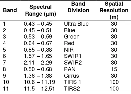
Data collected to LDCM Mission by the Operational Land Imager (OLI) instrument will improve the measurement capability in the future. With the "Ultra-Blue" band (Band 1) which is used for coastal and aerosols study, as well as Band 9 is useful for detecting cirrus clouds and two thermal bands provide more accurate surface temperature (TIRS 1 and TIRS 2). The spectral characteristics of Landsat 8 are shown in Table 2.
Table 2 Spectral characteristics of Landsat 8
Band Spectral
Overall Malang is located in Path 118 Row 066 on Landsat 8 image. This study uses the band 3, band 4 and band 5 for identification of spectral characteristics. Based on the planting data in Table 1, the spectral characteristics identification is examined for three varieties namely Ciherang, IR64 and Membramo. For this study, the sample data of rice field is planted on early August. To identify the characteristics for one rice growth cycle is used as much as 6 time series images with different acquisition date (August 13, 2013; August 29, 2013; September 14, 2013; September 30, 2013; October 16, 2013 and November 1, 2013). Some of the images that are acquired on November and December can not be used due to the existing of the clouds with a fairly high percentage.
Data Analisys
Data analysis performed in this study consists of two parts. The first is identification of the value of the digital number on each variety using band 3, 4, 5 and 6. The second is calculating the vegetation index value to determine differences in the pattern of the three varieties in one rice growth cycle.
This study uses 135 pixels that representing the pixels for IR64, Ciherang and Membramo for the analysis. These pixels are taken from 5 different agricultural areas in each acquisition date of Landsat image. Then, the average value was used to represent the value of each variety.
The vegetation indices analysis in this study used four methods that are normalized difference vegetation index (NDVI), ratio vegetation index (RVI), infrared percentage vegetation index (IPVI) and difference vegetation index (DVI). The formula of these vegetation indices are shown in Table 3.
Table 3. Several vegetation indices used in this study
Remarks: Where NIR and R are Near Infra Red and Red bands
RESULTANDDISCUSSION
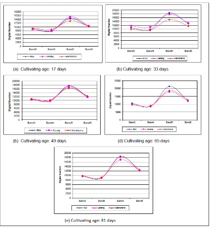
Identification of Digital Number for Three Varieties The figure that represents the relationship between Digital Number (DN) values with wavelength (band) of the three varieties is shown in Figure 1. Based on DN pattern on each band can be seen that all three varieties have nearly same spectral pattern. This is because all of these varieties have similar growth cycle time that is between 110 to 120 days.
Figure 1. Digital number of IR64, Ciherang, and Membramo
Up to the age plant of 47 days, all the bands have a tendency that the DN values always go up. At the age of 66 days, the DN value on band 3 and 4 start to decrease. But, the DN value on band 5 and 6 are likely to remain. Furthermore, both the DN value on bands 3, 4 and 5 are decrease, but the DN on band 6 is still
maturation levels, the chlorophyll and water content of the leaves also reduced. Therefore, both band 4 and 5 that are sensitive to this content will also have decreasing DN value. Based on the identification of DN value for three varieties, it can be seen that the spectral differences during the growing period viewed on the channel 5.
Vegetation Indices
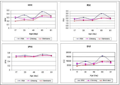
Spectral reflectance patterns of some plants will be different depending on the color of the leaves (chlorophyll), leaf structure and water content in the leaves. Vegetation indices pattern of three rice varieties is shown in Figure 2.
Figure 2 shows that the differences of vegetation indices patterns for the three varieties are clearly seen by using NDVI, RVI and DVI. Of the three varieties, IR64 has the most different pattern than the other two varieties. The peak reflectance of IR64 occurs at the age of 33 days and 68 days. For Ciherang, the peaks reflectance can be found on days 17 and 68. While peak reflectance of Membramo found at days 68. Of the three varieties, it can be identified that in average the peak reflectance is at the age of 68 days. At this age, the three varieties are in the reproductive phase in which the leaves of paddy is lush and entered a flowering period.
CONCLUSION
This study showed that three varieties have different variations of digital number (DN) on each band. However, all of them have the same spectral pattern. Based on the identification of patterns of digital values can be seen that Membramo varieties has a unique pattern, where at the beginning of the planting has a lowest DN value compared to IR64 and Ciherang. Then, after entering the reproductive phase and the beginning of the maturation phase, the value of DN goes up significantly. Based on the calculation of vegetation indices can be seen that the three varieties have a different growth pattern, where IR64 variety has a growth pattern that is most easily recognized than Membramo and Ciherang varieties. Based on the vegetation index figure, it can be seen that the NDVI technique, RVI and DVI can be used to distinguish the pattern of growth for Membramo, IR64 and Ciherang varieties.
ACKNOWLEDGEMENT
This research was funded by BOPTN research grants from Directorate General of Higher Education Ministry at 2013. In addition, this study uses Landsat 8 image data obtained from the USGS website (http://earthexplorer. usgs.gov/).
REFERENCES
BPPT. 2009. Description the variety of paddy. Centre of Research of Paddy Plant, BPPT, Agriculture Department.
Kim, H.O. and J.M. Yeom. 2012. Multi-temporal spectral analysis of rice fields in South Korea using MODIS and RapidEye Satellite Imagery. Journal of Astronomy and Space Sciences, 29(4): 407-411. http://dx.doi.org/10.5140/JASS.2012.2 9.4.407.
Nuarsa, I.W., F. Nishio and C. Hongo. 2011. Spectral characteristics and mapping of rice plants using multi-temporal landsat data. Journal of Agricultural Science 3(1): 54-67.
Panigrahy S., J.S. Parihar and N.K. Patel. 1992. Kharif rice estimation in orissa using NOAA-AVHRR data. Journal of The
Indian Society of Remote Sensing 20: 35-42.
Ribbes, F. and T. le Toan. 1999. Rice field mapping and monitoring with RADARSAT data. International Journal Remote Sensing 20(4): 745-765. Shao, Y., X. Fan and H. Liu, J. Xiao, S. Ross, B.
Brisco, R. Brown, and G. Staples. 2001. Rice monitoring and production estimation using multitemporal RADARSAT. Journal of Remote Sensing for Environment 76: 310-325. Sun, Hua-sheng, Jing-feng HUANG, A.R. Huete,
Dai-liang Peng, Feng Zhang. 2009. Mapping paddy rice with Multi-Date Moderate-Resolution Imaging Spectroradiometer (MODIS) data in China. Journal of Zhejiang University SCIENCE A. 10(10): 1509-1522. Strahler, A.H., L. Boschetti, G.M. Foody,
M.A.Friedl, M.C. Hansen, M. Herold, P. Mayaux, J.T. Morisette, S.V. Stehman, and C.E. Woodcock. 2006. Global land cover validation: Recommendation for evaluation and accuracy assessment of global land cover maps. Office for Official Publication of European Communities. [Online] Available. http://wgcv.ceos.org/docs/wgcv26/Glo ballandCoverValidation_JefMorisette.p df (June 2013).
Uchida, S. 2010. Monitoring of planting paddy rice with complex cropping pattern int the tropical humid climate region using Landsat and MODIS Data – A Case of West Java, Indonesia. International Archieves of The Photogrammetry, Remote Sensing and Spatial Information Science 38(8): 477- 481. Wataru, T., O. Taikan, and Y. Yoshifumi. 2006.