Open Geospatial Consortium
Submission Date: 2013-09-04 Approval Date: 2013-09-25 Publication Date: 2014-02-24 External identifier of this OGC® document: http://www.opengis.net/doc/DP/opensearch-correlated Internal reference number of this document: OGC 13-068
Category: Discussion Paper Editor: Pedro Gonçalves
OGC OpenSearch Extension for Correlated Search
Copyright © 2014 Open Geospatial Consortium.
To obtain additional rights of use, visit http://www.opengeospatial.org/legal/.
Warning
This document is not an OGC Standard. It is distributed for review and comment. It is subject to change without notice and may not be referred to as an OGC Standard.
Recipients of this document are invited to submit, with their comments, notification of any relevant patent rights of which they are aware and to provide supporting documentation.
Document type: Discussion Paper Document subtype:
Contents
Pagei. Preface ... iii
iii. Submitting organizations ... iii
iv. Document contributor contact points ... iv
v. Revision history ... iv
vi. Changes to the OGC Abstract Specification ... iv
Foreword ... v
Introduction ... vi
1 Scope ... 1
2 Compliance ... 1
3 Normative references ... 2
3.1 Other References ... 3
4 Terms and definitions ... 3
5 Conventions ... 4
5.1 Abbreviated terms ... 4
6 OpenSearch Correlation Extension ... 4
6.1 Application of correlation function to Interferometric Search ... 6
7 OpenSearch Description (Requirement) ... 7
7.1 Introduction ... 7
8 OpenSearch Correlation operation ... 8
8.1 Introduction ... 8
8.2 Search operation request ... 9
8.2.1 Search request parameters ... 9
8.2.2 Search request KVP encoding (mandatory) ... 10
8.3 Search operation response ... 10
8.3.1 Normal response parameters ... 10
8.3.2 Normal response XML encoding ... 11
8.3.3 Example of Extension Application ... 13
Annex A (normative) Abstract test suite ... 17
A.1 OpenSearch description document ... 17
A.2 ATOM Response Type ... 17
A.3 Spatial Correlation ... 17
A.4 Temporal Correlation ... 18
A.5 Correlation Function ... 18
Annex B (normative) XML Schema Documents ... 19
OGC 13-068
Copyright © 2014 Open Geospatial Consortium. iii
B.2. Geospatial Extension Query Element Schema
(schemas/opensearch/extensions/correlation/1.0/correlation.rnc) ... 20 B.3. Geospatial Extension ATOM Response Schema
(schemas/opensearch/extensions/correlation/1.0/atom.rnc) ... 21
Tables
PageTable 1 – Conformance Classes ... 2 Table 2 — Parameters in a Search operation request ... 9 Table 3 —Elements of Search operation response in the atom:feed element describing the search service ... 11 Table 4 —Elements of Search operation response in the atom:entry elements describing
each search result ... 12
i.
Preface
The document was initially produced during the ESA HMA (Heterogeneous Missions Accessibility) initiative [OR1] and related projects.
ii.
Document terms and definitions
This document uses the standard terms defined in Subclause 5.3 of [OGC 05-008], which is based on the ISO/IEC Directives, Part 2. Rules for the structure and drafting of
International Standards. In particular, the word “shall” (not “must”) is the verb form used to indicate a requirement to be strictly followed to conform to this standard.
iii.
Submitting organizations
The following organizations submitted this document to the Open Geospatial Consortium Inc.
iv.
Document contributor contact points
All questions regarding this document should be directed to the editor or the contributors:
Name Organization Email
Pedro Goncalves Terradue Srl [email protected]
v.
Revision history
Date Release Editor Primary clauses modified
Description
2013-05-15 0.0.1 Pedro Gonçalves
Consolidation of Correlated Search Extension
vi.
Changes to the OGC Abstract Specification
OGC 13-068
Copyright © 2014 Open Geospatial Consortium. v
Foreword
This document describes an OpenSearch extension to deal with correlated discovery among different search feeds obtained from one or more search engines. The intended scope of this extension is to improve OpenSearch Geospatial and OpenSearch Earth Observation Services but it can be applied in other contexts.
Attention is drawn to the possibility that some of the elements of this document may be the subject of patent rights. The Open Geospatial Consortium shall not be held
responsible for identifying any or all such patent rights.
Introduction
The OpenSearch specification originated in a community effort built around Amazon's A9.com. It was intended to allow syndication of search results that could then be
aggregated by one large index. The OpenSearch specification is made available under the Creative Commons Attribution-Sharealike 2.5 license.
OpenSearch is a collection of simple formats for the sharing of search results. The OpenSearch description document format can be used to describe a search engine so that it can be used by search client applications. The OpenSearch description format allows the use of extensions that allow search engines to request a specific and contextual query parameter from search clients.
OGC® Discussion Paper OGC 13-068
Copyright © 2014 Open Geospatial Consortium. 1
1 Scope
This OGC discussion paper presents an OpenSearch query protocol extension for the execution of correlation queries between different Search Feeds. Services that support the OpenSearch Specification and Correlation extension defined in this document are called OpenSearch Correlation Services. With the proposed extensions it will be possible to execute distributed queries with correlation and search criteria defining the results aggregation.
2 Compliance
Conformance with this standard shall be checked using all the relevant tests specified in Annex A (normative) of this document. The framework, concepts, and methodology for testing, and the criteria to be achieved to claim conformance are specified in the OGC Compliance Testing Policies and Procedures and the OGC Compliance Testing web site1.
In order to conform to this OGC® interface standard, a software implementation shall choose to implement any one of the conformance levels specified in Annex a
(normative).
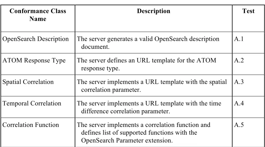
All requirements-classes and conformance-classes described in this document are owned by the specification identified as http://www.opengis.net/spec/opensearchcorrelation/1.0. The following table describes the conformance classes defined in this standard:
Table 1 – Conformance Classes
Conformance Class Name
Description Test
OpenSearch Description The server generates a valid OpenSearch description document.
A.1
ATOM Response Type The server defines an URL template for the ATOM response type.
A.2
Spatial Correlation The server implements a URL template with the spatial correlation parameter.
A.3
Temporal Correlation The server implements a URL template with the time difference correlation parameter.
A.4
Correlation Function The server implements a correlation function and defines list of supported functions with the OpenSearch Parameter extension.
A.5
3 Normative references
The following normative documents contain provisions that, through reference in this text, constitute provisions of this document. For dated references, subsequent
amendments to, or revisions of, any of these publications do not apply. For undated references, the latest edition of the normative document referred to applies.
ATOM - The Atom Syndication Format (IETF RFC4287)
OASIS OpenSearch - searchRetrieve: Part 4. APD Binding for OpenSearch Version 1.0, OASIS Standard, 30 January 2013,
http://docs.oasis-open.org/search- ws/searchRetrieve/v1.0/os/part4-opensearch/searchRetrieve-v1.0-os-part4-opensearch.html
OGC 06-121 - OWS Common Implementation Specification
OGC 06-103r4 - OpenGIS® Implementation Standard for Geographic information - Simple feature access - Part 1: Common architecture
OGC 10-032 - OpenSearch GeoSpatial and Temporal Extensions
OGC 10-157 – Earth Observation Metadata profile of Observation & Measurements OGC 13-026 - OpenSearch Extension for Earth Observation
OGC 13-068
Copyright © 2014 Open Geospatial Consortium. 3
RFC 3339 - Date and Time on the Internet: Timestamps. Internet profile of the ISO 8601 standard for representation of dates and times using the Gregorian calendar.
http://www.ietf.org/rfc/rfc3339.txt
RFC 5646 - Tags for Identifying Languages - http://tools.ietf.org/html/rfc5646 RFC 5988 - Web Linking - http://tools.ietf.org/html/rfc5988
http://www.iana.org/assignments/link-relations/link-relations.xhtml
3.1 Other References
HMA - Heterogeneous Missions Accessibility – Design Methodology, Architecture and Use of Geospatial Standards for the Ground Segment Support of Earth Observation missions ESA TM-21 http://www.esa.int/About_Us/ESA_Publications/ESA_TM- 21_Heterogeneous_Missions_Accessibility
OGC 07-147r2 - OGC KML Specification
W3C RDF - W3C RDF Specification Suite - http://www.w3.org/RDF/
4 Terms and definitions
For the purposes of this standard, the definitions specified in Clause 4 of the OWS Common Implementation Specification [OGC 06-121] shall apply. In addition, the following terms and definitions apply.
4.1
OpenSearch
Draft specification for web search syndication, originating from Amazon's A9 project and given a corresponding interface binding by the OASIS Search Web Services working group.
4.2
OpenSearch Geospatial Service
Defines servers that comply with the OpenSearch Specification and the Geospatial extension defined in OGC 10-032 “OpenSearch GeoSpatial and Temporal Extensions”
4.3
OpenSearch Description Document
An XML document available at a consistent location describing metadata for the service and providing templates for queries.
4.4
OpenSearch Earth Observation Service
4.5
OpenSearch Correlation Services
Defines serves that comply with the OpenSearch Specification and the Correlation extension defined in this document
4.6
Search Feed
The response document of search service request containing zero or several entries.
4.7
Entry
An element of the search response representing a catalogued resource.
5 Conventions
5.1 Abbreviated terms
Some of the abbreviated terms listed in Subclause 5.1 of the OWS Common
Implementation Specification [OGC 06-121] apply to this document, plus the following abbreviated terms.
ESA European Space Agency
OASIS Advancing Open Standards for the Information Society SWS Search Web Services
URL Uniform Resource Locator
6 OpenSearch Correlation Extension
As the operations of the main OpenSearch specification are expressed in the OASIS SWS bindings [OASIS OpenSearch], we confine ourselves here to the operations of the
OpenSearch Correlation extension. This specification is complementary to the
“OpenSearch Geo Spatial and Temporal Extensions” (OGC 10-032) and “OpenSearch Extension for Earth Observation” (OGC 13-026) and requires their applicability for some of the functionality described.
The purpose of this extension is to define correlated searches methods. From an initial search feed, the extension allows definition of linkages to other search feeds originating from potentially different search engines. This latter allows the integration of several search feeds and creates relations between the different entries. This extension defines the correlation of entries in terms of:
a. Spatial footprint
OGC 13-068
Copyright © 2014 Open Geospatial Consortium. 5
A sample of a Description showing the use of Correlation Extension with several output formats search results can be seen in Example 2.
Geo-Temporal Correlation Search
The search engine performs a correlation search when the results are combined with entries that originate from other Search Feeds and that match a given correlation criteria. This extension extends an OpenSearch Geospatial Service and, as such, each OpenSearch Correlation Service performing Geo-Temporal Correlation must comply with the
OpenSearch Geospatial Service (OGC 10-032).
To perform a correlation search it is necessary to define one URL of the Correlated Search feed (i.e. slave feed) that will be correlated with the search engine feed (i.e.
master feed). The correlation feed may originate from the same or from a different Search Engine. The URL identifying the correlation feed is opaque to the Search Engine and it may carry specific search criteria or parameters that the search engine must not alter. The slave feed URL must have the same encoding2 of the master feed.
It is also necessary to define the correlation criteria that will be applied on Search Feeds. This extension allows the correlation criteria to be defined in terms of overlapping time and space. For time the extension allows the definition of the number or range of time between the entries and for space it defines the percentage of spatial intersection of the spatial representations.
The correlation URL and criteria are defined as parameters of a Search Feed that will be considered as the master. Each entry of the search feed will be correlated with the results originating from the Correlated Search feeds. For the spatial correlation the percentage is expressed as the minimal percentage of the master entry footprint that must be
overlapped by another product to consider that both entries correlate. For the time correlation it is the time interval of every master entry that will define the search period for the entries in the correlated search feeds.
Suppose that we have an initial search feed accessible in URL #1 with the master entries: http://catalog.space/meris?bbox=10,10,20,20
And we want to correlate each entry with entries from another feed from URL #2 that contains the slave entries:
http://catalog.space/modis?bbox=12,12,18,18
To associate each master entry making sure that each entry overlap more than 50% it will be necessary to add the encoded URL #2 and the spatial condition as new parameters to URL #1 expressing that new condition and making the URL #3:
http://catalog.space/meris?bbox=10,10,20,20&spatialcover=50&correlatedto=http:% 2F%2Fcatalog.space%2Fmodis%3Fbbox%3D12,12,18,18
All the slave entries are compared for each master entry and both entries are correlated if the percentage of the spatial representation of the master entry covered by the spatial representation of slave entry is equal or greater to the space overlap percentage requested. For example, with a 50% spatial cover criterion, at least 50% of the master entry must be covered by the slave entry in order for the slave entry to be selected.
For the time correlation, the criterion is expressed as a date offset range (with a minimum and maximum time values that can be positive or negative). The data offset range will be applied to each master feed entry in order to select the slave entries that have the
temporal representation (e.g. acquisition time) within the selected range.
This extension also defines the minimum number of correlated entries. With the default value of 1 the minimum means that a master entry must have at least one slave entry in order to appear on the resulting feed.
Even if the slave URL is opaque to the OpenSearch Earth Observation Correlation Service, the service may use the feed information (e.g. link to OpenSearch Description) to create a valid feed subset in order to improve performance.
To allow the extensibility of the correlation methods this extension defines a function parameter that will allow the server to perform a named correlation function based on the slave and master entry elements values. When this function parameter is available the OpenSearch Correlation Service must provide in the OpenSearch Description a list of the available named functions using the Parameter element of the OpenSearch Parameter Extension3.
This extension makes no assumption of the function names or their quality. The naming of the function is local to the service and agreement on their capabilities and parameter is outside this specification and it may be target of future specification.
6.1 Application of correlation function to Interferometric Search
The interferometric search is a special case of a correlation search dealing with specific Radar imagery information (e.g. Sentinel-1, ERS, Envisat). It shares the same process and outputs but have quite different purposes and contexts. Interferometric search is only performed when products to be combined are acquired by the same mission in compatible phases (i.e. in phases having the same orbit scheme) and as such it implies that the
OpenSearch is compliant with the the “OpenSearch Geo Spatial and Temporal
Extensions” (OGC 10-032) and “OpenSearch Extension for Earth Observation” (OGC 13-026).
OGC 13-068
Copyright © 2014 Open Geospatial Consortium. 7
EXAMPLE 1 A OpenSearch Description from a repository supporting a named function of the OpenSearch Correlation Extension. The OpenSearch Parameter extension elements are used to inform clients of the correlation functions available and parameter format:
<?xml version="1.0" encoding="UTF-8"?>
<OpenSearchDescription xmlns="http://a9.com/-/spec/opensearch/1.1/"
<LongName>Example.com Web Search</LongName>
<Description>Use Example.com to search the Web.</Description> <Tags>example web</Tags>
<param:Parameter name="function" value="{cor:function}" minimum="0" title=”Correlation Functions”>
<param:Option value="interferometric" label=”Interferometric Search”/> </param:Parameter>
<param:Parameter name="param" value="{cor:parameter}" minimum="0" title="Correlation Parameters" pattern="burst:[\+\-]?[\d]*,baseline:[\+\-]?[\d]*" />
<Attribution>Copyright 2013, Example.com, Inc.</Attribution> <SyndicationRight>open</SyndicationRight>
</OpenSearchDescription>
The interferometric uses the basic correlation parameters for time difference and spatial coverage and adds a special correlation function with corresponding parameters (baseline and burst sync). This function has special validity periods that are dependent on the search engine items (i.e. the periods where the Earth Observation missions have coordinated phases) that are defined as part of the Search Service configuration can be expressed using the OpenSearch Descripton Parameter extensions. The function parameters format can also be specified as defined in Example 1.
The general process of the interferometric search follows the same as in the spatial and temporal correlation but forces the server to execute an additional check to assure the slave entry validity. For each, it checks if it has the same track number, sensor mode and swath identifier (as defined OGC 13-026) of the master product. Then, for every slave candidate product, the center time from the overlap area is computed and obtains the baseline and time from topsar values stored in the auxiliary files. If then those
interferometric correlation criteria are also met (burst synch values are computed from the ‘time from topsar’ for that purpose) then the slave entry is accepted.
7 OpenSearch Description (Requirement)
7.1 Introduction
The OpenSearch Description Document allows clients to retrieve service metadata from a server. The response to a request for a Description shall be an XML document in the form specified by the SWS OpenSearch bindings published by OASIS. A brief summary of the Description's requirements is provided in OGC 10-032.
<?xml version="1.0" encoding="UTF-8"?>
<OpenSearchDescription xmlns="http://a9.com/-/spec/opensearch/1.1/" xmlns:geo="http://a9.com/-/opensearch/extensions/geo/1.0/"
xmlns:cor="http://a9.com/-/opensearch/extensions/correlation/1.0/"> <ShortName>Web Search</ShortName>
<LongName>Example.com Web Search</LongName>
<Description>Use Example.com to search the Web.</Description>
<Url type="application/atom+xml" template="http://example.com/myatom/? pw={startPage?}&bbox={geo:box?}&correlatedTo={cor:with?}&spatial Cover={cor:spatial?}"/>
<Url type="text/html" template="http://example.com/html/?
pw={startPage?}&bbox={geo:box?}&correlatedTo={cor:to?}&spatialCover ={cor:spatial?}"/>
<Attribution>Copyright 2013, Example.com, Inc.</Attribution> <SyndicationRight>open</SyndicationRight>
</OpenSearchDescription>
8 OpenSearch Correlation operation
8.1 Introduction
OpenSearch Correlation Extension is designed to provide a correlation search facility to the OpenSearch protocol. One namespace is provided for use in URL templates that form part of the OpenSearch Description Document (see Example 1), published by the server in XML at a stable URL.
Requirements Class
http://www.opengis.net/spec/opensearchcorrelation/1.0/req/req-class-a
Target type Token
Requirement http://www.opengis.net/spec/opensearchcorrelation/1.0/req/req-class-a/namespaces
This namespaces and a corresponding namespace prefix shall be included when the extension is used in an OpenSearch Description document:
http://a9.com/-/opensearch/extensions/correlation/1.0/
The flexibility of the OpenSearch protocol allows one to return lists of search results in any format that a client can be persuaded to understand. A server provides a description document that a client reads to determine how to formulate a search/retrieve request and interpret the response. Where several request templates are provided, a client may choose the one offering the most useful format (specified by MIME-type defined in the type attribute of the element) as shown in Example 2. An OpenSearch Correlation Service defines at least an URL template for the ATOM response format.
Requirements Class
http://www.opengis.net/spec/opensearchcorrelation/1.0/req/req-class-a
Target type Token
http://www.opengis.net/spec/opensearchcorrelation/1.0/req/req-class-OGC 13-068
Copyright © 2014 Open Geospatial Consortium. 9
a/response_payload
Any server supporting the Earth Observation extension shall at least return results in Atom 1.0
8.2 Search operation request
8.2.1 Search request parameters
Table 2 — Parameters in a Search operation request
Names
a Definition Data type and values Multiplicity and use
EO Correlated Search Extension (http://a9.com/-/opensearch/extensions/eo-correlation/1.0/) with An encoded URLs representing
the search feed in same encoding as the search engine requested c.
URL One (optional)
Mandatory if any item below is present time A pair of integer numbers
representing the number of seconds separating the search engine results with the correlated items.
Two integer numbers separated by a comma. Ex: n1,n2
One (optional)
spatial A number representing the minimum percentage of spatial coverage necessary between the search engine results and the correlated items.
Number from 0 to 100. One (optional)
minimum A number representing the minimum numbers of correlated entries
An non negative integer One(optional) Default is 1
function A string identifying the local correlation function that will be applied to select the correlated items.
Character String One (optional)b
parameters A string identifying the local parameters of the correlation function
Character String One (optional)c
a The name capitalization rules being used here are specified in Subclause 11.6.2 of [OGC 05-008]. b When this value is present on the URL template of the OpenSearch Description the document shall also include the valid parameters values with the OpenSearch Parameter Extension
c Format of parameters must ABNF rules, as specified in RFC 2234: parameters = namevalue *(“,” namevalue )
namevalue = name “:” value name = *pchar
value =*pchar
8.2.2 Search request KVP encoding (mandatory)
Requirements Class
http://www.opengis.net/spec/opensearchcorrelation/m.n/req/req-class-b
Target type Token
Requirement http://www.opengis.net/spec/opensearchcorrelation/1.0/req/req-class-b/http_get_transfer
Servers shall implement HTTP GET transfer of the Search operation request, using KVP encoding.
Requirement http://www.opengis.net/spec/opensearchcorrelation/1.0/req/req-class-b/url_parameters
The KVP encoding of the Search operation request shall use the parameters templates specified in the OpenSearch Description of the Service.
Requirement http://www.opengis.net/spec/opensearchcorrelation/1.0/req/req-class-b/search_parameters
The URL parameters templates shall be as specified in Table 2.
Note that for the given key-value pairs, the key can be an arbitrary string, specified by one given instance of an OpenSearch repository. For example, one Description may provide a URL template asking for correlation={cor:correlatedTo}, another specifying cor={cor:correlatedTo}. It is the responsibility of the client application to parse the URL template and create the appropriate keys for each key-value pair. These parameter sets are templates from which URLs can be constructed. The search client must replace every instance of a template parameter with a value before the search request is performed. If a search engine wishes to indicate that a template parameter is optional and can be replaced with the empty string, then the "?" notation described in the section on optional template parameters should be used. Clients should take special consideration to the fact that according to the OpenSearch specification the OpenSearch parameters usage is not restricted to the URL query string and can be used as templates values in any of URL components (e.g. path, host).
8.3 Search operation response
8.3.1 Normal response parameters
OGC 13-068
Copyright © 2014 Open Geospatial Consortium. 11
8.3.2 Normal response XML encoding
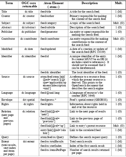
Table 3 —Elements of Search operation response in the atom:feed element describing the search service
Term OGC core
returnable
Atom Element ( atom: )
Description Mult.
Title dc:title feed/title A title for the search feed. 1 (M) Creator dc:creator feed/author Primary responsible for making
the content of the search feed
1 (M) Subject dc:subject feed/category A topic of the search feed. Mult. (O) Abstract dct:abstract feed/subtitle Description of the search feed 1 (O) Publisher dc:publisher feed/generator An entity or agent responsible for
making the search feed.
1 (O) Contributor dc:contributor feed/contributor An entity responsible for making
contributions to the content of the search feed
Mult. (O)
Modified dc:date feed/updated A date of a creation or update of the search feed (RFC 33339)
1 (M) Identifier dc:identifier feed/id A unique identifier of the entry.
Its content MUST be an IRI (it excludes relative references). It should not be assumed that it can be dereferenced.
1 (M)
feed/dc:identifier The local identifier of the feed. 1 (O) Source dc:source atom:feed/atom:link[
@rel=’search’][@t ype=‘application/op ensearchdescription +xml‘]
A reference to a resource from which the present resource is derived. This points to the OpenSearch document that describes the search engine
1 (O)
Language dc:language feed/@xml:lang A language of resource’s the content (RFC 5646)
1 (O) Envelope dct:spatial feed/georss:* Feed’s spatial extent (GEORSS). 1 (O) Rights dc:rights feed/rights Information about rights held in
and over the resource
1 (O)
Link to the previous page of results
1 (O) feed/link[@rel=’up’] Link to entry’s parent resource Mult. (O) entry/link[@rel=’rela
tion’]
Link to the correlated feed 1 (M) Query - atom:feed/os:Query Defines the search request query. 1 (O) Extent
(total results, start index and items per page)
dct:extent feed/os:totalResults Total search results 1 (M) feed/os:startIndex Index of the first search result. 1 (M) feed/os:itemsPerPage Number of search results returned
per page.
1 (M)
Table 4 —Elements of Search operation response in the atom:entry elements describing each search result
Term OGC core
returnable
Atom Element atom:
Description Mult.
Title dc:title entry/title A title given to the resource. 1 (M) Creator dc:creator entry/author An entity primarily responsible
for making the content of the resource.
1 (O)
Subject dc:subject entry/category A topic of the resource. Mult. (O) Abstract dct:abstract entry/summary An description of the resource. 1 (O) Contributor dc:contribut
or
entry/contributor An entity responsible for making contributions to the content of the resource.
Mult. (O)
Modified dc:date entry/updated Creation or update date of the metadata resource (RFC-3339).
1 (M) Date - entry/dc:date A date or range of dates relevant
to the resource (RFC-3339)a.
1 (O) Identifier dc:identifier entry/id A unique identifier of the entry.
Its content MUST be an IRI (it excludes relative references). It should not be assumed that it can be dereferenced.
1 (O)
entry/dc:identifier The identifier of the resource within the search engine context (local reference).
1 (O)
Source dc:source entry/link[@rel=‘via’] A reference to a resource from which the present resource is derived (metadata document)
Mult. (O)
Language dc:language entry/@xml:lang Language of the content of the resource (RFC 5646)
1 (O) Rights dc:rights entry/rights Information about rights held in
and over the resource.
1 (O) Envelope dct:spatial entry/georss:* The spatial extent of the resource 1 (O) Relation dc:relation entry/link[@rel=’searc
h’]
OpenSearch description document (entry is a search service).
1 (O) entry/link[@rel=’enclo
sure’]
Location of the data resource described in the entry.
Mult. (O) entry/link[@rel=’icon’] Links to entry’s quicklook image. Mult. (O) entry/link[@rel=’up’] Links to entry’s parent resource Mult. (O) entry/link[@rel=’relati
on’]
Links to the entry’s correlated resources
Mult. (O) Format dc:format entry/link[@rel=’enclo
sure’]/@type
The MIME types of the data resources available.
Mult. (O) a
When specifying a temporal range the element should contain two dates separated by a slash, like: <dc:date>2004-02-19T03:03:23.736Z/2010-09-12T15:57:36.072Z</dc:date>
OGC 13-068
Copyright © 2014 Open Geospatial Consortium. 13
8.3.3 Example of Extension Application
Suppose that you search on a OpenSearch Search Engine with the Correlation Extensions for a given information on a very precise time. For example if we have a given feed shown in Example 3.
EXAMPLE 3 A request for a search engine using the OpenSearch Time extension:
http://web.site/search/ER01_SAR_IM__0P/atom/? start=1992-11-03T02:14:55Z&
stop=1992-11-03T02:15:00Z
We obtained the entry represented by the footprint shown in Error! Reference source not found..
Figure 1 – A footprint of an satellite image taken in November 1992
Now we have another feed (Example 4) from another catalogue that tells us that there are others images on the same area before and after the one we found (Figure 2).
EXAMPLE 4 A request for a search engine using the OpenSearch Time and Geospatial extensions:
http://another.site/search/ER01_SAR_IM__0P/atom/? start=1992-01-01T00:00:00Z&
stop=1993-12-31T23:59:59.99Z& bbox=120,40.89,129.74,42.83
So now we want to perform a correlated search to select only the entries of Figure 2 that cover at least 95% of the one shown in Figure 1. Using the Correlation extension it is necessary to join both feeds and express the spatial range of 95%. The URL would be something like the one shown on Example 5.
EXAMPLE 5 A request for a search engine using the OpenSearch Time and Correlation extensions:
http://web.site/search/ER01_SAR_IM__0P/atom/? start=1992-11-03T02:14:55Z& stop=1992-11-03T02:15:00Z& spaceCover=95&
with=http%3A%2F%2Fanother.site%2Fsearch%2FER01_SAR_IM__0P
%2Fatom%2F%3Fstart%3D1992-01-01T00%3A00%3A00Z%26stop%3D1993-12-31T23%3A59%3A59.99Z%26bbox%3D120%2C40.89%2C129.74%2C42.83%26%0A
Now the result will be the same of Example 3 with the major difference that now the feed entry was enriched with links to the other entries. Not all entries of Example 4 were selected but only those spatially cover our feed entry more that 95%. As specified in Table 3 and Table 4 the way to express correlation between the feeds and the entry is by using a atom:link with the “related” relation. Example 6 shows a response of this
example.
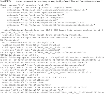
EXAMPLE 6 A response request for a search engine using the OpenSearch Time and Correlation extensions:
<?xml version="1.0" encoding="utf-8"?>
<feed xml:lang="en" xmlns="http://www.w3.org/2005/Atom"
xmlns:time="http://a9.com/-/opensearch/extensions/time/1.0/" xmlns:os="http://a9.com/-/spec/opensearch/1.1/"
xmlns:dc="http://purl.org/dc/elements/1.1/" xmlns:georss="http://www.georss.org/georss" xmlns:gml="http://www.opengis.net/gml"
xmlns:geo="http://a9.com/-/opensearch/extensions/geo/1.0/"
xmlns:cor="http://a9.com/-/opensearch/extensions/correlation/1.0/" >
<title>Catalogue Search Feed for ERS-1 SAR Image Mode source packets Level 0 (ER01_SAR_IM__0P)</title>
<subtitle type="html">One result found.<br/></subtitle> <generator uri="http://www.terradue.com" version="1.4.0">Terradue CAS</generator>
<updated>2013-07-04T21:27:21Z</updated> <author><name>GEO SuperSites</name></author>
<id>http://web.site/search/ER01_SAR_IM__0P/atom</id> <link rel="self" type="application/atom+xml"
href="http://web.site/search/ER01_SAR_IM__0P/atom/?start=1992-11-
03T02:14:55Z&stop=1992-11-03T02:15:00Z&spaceCover=95&with=http%3A%2F%2Fanother.site%2Fsearch%2FER 01_SAR_IM__0P %2Fatom%2F%3Fstart%3D1992-01-01T00%3A00%3A00Z%26stop%3D1993-12-31T23%3A59%3A59.99Z%26bbox%3D120%2C40.89%2C129.74%2C42.83%26%0A"/>
<link rel="search" type="application/opensearchdescription+xml" href="http://web.site/search/ER01_SAR_IM__0P/description"/> <link rel="related" type="pplication/opensearchdescription+xml"
<os:Query role="request" time:start="start=1992-11-03T02:14:55Z" time:end="1992-11-03T02:15:00Z" cor:spatial="95"
OGC 13-068
Copyright © 2014 Open Geospatial Consortium. 15
<published>2012-03-02T21:10:32.000Z</published>
<updated>2013-05-16T22:25:57.124Z</updated>
<dc:date>1992-11-03T02:14:52.680Z/1992-11-03T02:15:10.063Z</dc:date> <georss:where><gml:Polygon><gml:exterior><gml:LinearRing><gml:posList srsDimension="2">42.3565 128.762 42.5582 127.5019 41.3609 127.1641 41.1685 128.3685 42.3565
128.762</gml:posList></gml:LinearRing></gml:exterior></gml:Polygon></georss:whe re>
<link rel="alternate" type="application/atom+xml" title="ATOM entry link" href="http://web.site/search/ER01_SAR_IM__0P/ER01_SAR_IM__0P_19921103T021452_19 921103T021509_DPA_06804_0000/atom"/>
<link rel="alternate" type="application/vnd.google-earth.kml+xml" title="KML file"
href="http://web.site/search/ER01_SAR_IM__0P/ER01_SAR_IM__0P_19921103T021452_19 921103T021509_DPA_06804_0000/kml"/>
<link rel="alternate" type="text/html" title="HTML page"
href="http://web.site/search/ER01_SAR_IM__0P/ER01_SAR_IM__0P_19921103T021452_19 921103T021509_DPA_06804_0000/html"/>
<link rel="via" type="application/rdf+xml" title="RDF metadata entry" href="http://web.site/search/ER01_SAR_IM__0P/ER01_SAR_IM__0P_19921103T021452_19 921103T021509_DPA_06804_0000/rdf"/>
<link rel="enclosure" type="application/binary" length="212228962" title=" File ER01_SAR_IM__0P_19921103T021452_19921103T021509_DPA_06804_0000.CEOS.tar.gz in the ESA format"
href="https://web.site/supersites/ER01_SAR_IM__0P_19921103T021452_19921103T0215 09_DPA_06804_0000.CEOS.tar.gz"/>
<content type="html">
<ul><li> <b>Date</b>: 1992-11-03 <br/> (1992-11-03T02:14:52.680Z / 1992-11-03T02:15:10.063Z) </li> <li> <b>Orbit Number</b>: 6804 </li>
<li> <b>Processing Center</b>: D-PAF </li> <br/>
<link title="ER01_SAR_IM__0P_19920512T021442_19920512T021459_DPA_04299_0000" href="http://another.site/search/ER01_SAR_IM__0P/ER01_SAR_IM__0P_19920512T02144 2_19920512T021459_DPA_04299_0000/atom" type="application/atom+xml"
rel="related"/>
<link title="ER01_SAR_IM__0P_19920825T021456_19920825T021513_DPA_05802_0000" href="http://another.site/search/ER01_SAR_IM__0P/ER01_SAR_IM__0P_19920825T02145 6_19920825T021513_DPA_05802_0000/atom" type="application/atom+xml"
rel="related"/>
<link title="ER01_SAR_IM__0P_19921208T021443_19921208T021500_DPA_07305_0000" href="http://another.site/search/ER01_SAR_IM__0P/ER01_SAR_IM__0P_19921208T02144 3_19921208T021500_DPA_07305_0000/atom" type="application/atom+xml"
rel="related"/>
<link title="ER01_SAR_IM__0P_19920616T021448_19920616T021505_DPA_04800_0000" href="http://another.site/search/ER01_SAR_IM__0P/ER01_SAR_IM__0P_19920616T02144 8_19920616T021505_DPA_04800_0000/atom" type="application/atom+xml"
rel="related"/>
2_19930601T021459_DPA_09810_0000/atom" type="application/atom+xml" rel="related"/>
OGC 13-068
Copyright © 2014 Open Geospatial Consortium. 17
Annex A
(normative)
Abstract test suite
A.1 OpenSearch description document
Test Purpose: Verify that the server generates a valid OpenSearch description document.
Test Method: Execute an HTTP GET request to retrieve a server's description document. Verify that the response is correct XML and is valid according to the description in this standard.
References: Section 8 Test type: Capability
A.2 ATOM Response Type
Test Purpose: Verify that the server defines an URL template for the ATOM response. Test Method: Execute an HTTP GET request to retrieve a server's description
document. Verify that an URL element with the type equal to “application/atom+xml” exists.
References: Section 9.1 Test type: Capability
A.3 Spatial Correlation
Test Purpose: Verify that the server implements a URL template with the type “application/atom+xml” and uses the Spatial Correlation OpenSearch parameter in the template.
Test Method: Execute an HTTP GET request to retrieve a server's description document. Verify that the URL template includes parameters cor:correlatedTo and cor:spatialCover
A.4 Temporal Correlation
Test Purpose: Verify that the server implements a URL template with the type
“application/atom+xml” and uses the Temporal Correlation OpenSearch parameter in the template.
Test Method: Execute an HTTP GET request to retrieve a server's description document. Verify that the URL template includes parameters cor:correlatedTo and timeCover.
References: Section 9.1 Test type: Capability
A.5 Correlation Function
Test Purpose: Verify that the server implements a URL template with the type
“application/atom+xml” and uses the Correlation Function OpenSearch parameter in the template.
Test Method: Execute an HTTP GET request to retrieve a server's description document. Verify that the URL template includes parameters cor:correlatedTo and cor:function. Verify if it includes a Parameter OpenSearch element enumerating the different functions available. References: Section 9.1
OGC 13-068
Copyright © 2014 Open Geospatial Consortium. 19
Annex B
(normative)
XML Schema Documents
B.1. Correlation Extension Description Document Schema (schemas/opensearch/extensions/correlation/1.0/osddcor.rnc)
# -*- rnc -*-
# RELAX NG Compact Syntax Grammar for
# OpenSearch Description Document with the Geo Extension
namespace os = "http://a9.com/-/spec/opensearch/1.1/" namespace s = "http://purl.oclc.org/dsdl/schematron" namespace local = ""
namespace cor = "http://a9.com/-/opensearch/extensions/correlation/1.0/"
include "correlation.rnc"
# Replacing definitions on RFC4287 plus OpenSearch include "../../../1.1/osdd.rnc"{
undefinedAttribute = attribute * - (local:* | cor:* ) { text }
osDocument = [
s:pattern [ name="atom"
s:rule [ context = "os:OpenSearchDescription"
s:assert [ test = "os:Url[@type='application/atom+xml']" before(@template,'{cor:with')!='' and ( substring-before( @template, '{cor:time' ) != '' or before(@template,'{cor:spatial')!='' or
substring-before(@template,'{cor:function')!='' ) ]"
"An OpenSearch Description Document must have at least a cor:with and a spatial, temporal or a correlation function "
~ " in the ATOM response." ]] ]
]
element os:OpenSearchDescription { osDocumentConstruct }
B.2. Geospatial Extension Query Element Schema
(schemas/opensearch/extensions/correlation/1.0/correlation.rnc)
# -*- rnc -*-
# RELAX NG Compact Syntax Grammar
# OpenSearch Query Element as defined in OGC 13-068 for the correlation extension
namespace cor = "http://a9.com/-/opensearch/extensions/correlation/1.0/"
osQueryAttr &= attribute cor:with { xsd:anyURI }
& attribute cor:time { xsd:string { pattern = "[\+\-]?[\d]*,[\+\-]?[\d]*" } }?
& attribute cor:spatial { xsd:string { pattern ="[\d]{1,2}|100" } } ?
& attribute cor:minimum { xsd:string { pattern = "[\d]*" } } ? & attribute cor:function { text } ?
& attribute cor:parameters { xsd:string { pattern ="(\w+):(\w+)?(,(\w+):(\w+))*" } }?
OGC 13-068
Copyright © 2014 Open Geospatial Consortium. 21
B.3. Geospatial Extension ATOM Response Schema (schemas/opensearch/extensions/correlation/1.0/atom.rnc)
# -*- rnc -*-
# RELAX NG Compact Syntax Grammar for
# ATOM encoding and foreign elements as defined in OGC 13-068 # for the correlation extension
namespace atom = "http://www.w3.org/2005/Atom"
namespace os = "http://a9.com/-/spec/opensearch/1.1/" namespace dc="http://purl.org/dc/elements/1.1/"
namespace geo = "http://a9.com/-/opensearch/extensions/geo/1.0/" namespace georss="http://www.georss.org/georss"
namespace s = "http://purl.oclc.org/dsdl/schematron" namespace local = ""
# Redefine atom:feed to include new OGC10-032 elements
atomFeedConstruct &= georssElement ? & element dc:identifier { xsd:token } ?
# Redefine atom:entry to include new OGC10-032 elements
atomEntryConstruct &= georssElement ? & element dc:identifier { xsd:token } ?
include "geo.rnc"
include "../../../../georss/1.1/georss.rnc"
# Replacing definitions on RFC4287 plus OpenSearch include "../../../1.1/osatom.rnc"{
# Redefine the Structured Extension to exclude owc:* elements structuredExtensionElement = element * -
~ " ( @type equal to 'html' is recommended)"]]
s:rule [ context = "atom:entry"
s:assert [ test = "atom:link[@rel='alternate'] " ~ "or atom:link[not(@rel)] or atom:content"
"An atom:entry must have at least one atom:link element " ~ "with a rel attribute of 'alternate' or an atom:content."]]
s:rule [ context = "atom:entry" s:assert [ test = "atom:author or "
~ "../atom:author or atom:source/atom:author" "An atom:entry must have an atom:author " ~ "if its feed does not."]]
s:rule [ context = "atom:entry" s:assert [ test = "georss:* or "
~ "../georss:* "
"An atom:entry must have an georss element " ~ "if its feed does not."]]
]
element atom:entry { atomEntryConstruct } }