Open Geospatial Consortium, Inc.
OpenGIS
Simple Features Specification
For CORBA
Revision 1.1
Date: June 2, 1999
Copyright © Open Geospatial Consortium, Inc (2005)
License Agreement
Permission is hereby granted by the Open Geospatial Consortium, ("Licensor"), free of charge and subject to the terms set forth below, to any person obtaining a copy of this Intellectual Property and any associated documentation, to deal in the Intellectual Property without restriction (except as set forth below), including without limitation the rights to implement, use, copy, modify, merge, publish, distribute, and/or sublicense copies of the Intellectual Property, and to permit persons to whom the Intellectual Property is furnished to do so, provided that all copyright notices on the intellectual property are retained intact and that each person to whom the Intellectual Property is furnished agrees to the terms of this Agreement.
If you modify the Intellectual Property, all copies of the modified Intellectual Property must include, in addition to the above copyright notice, a notice that the Intellectual Property includes modifications that have not been approved or adopted by LICENSOR.
THIS LICENSE IS A COPYRIGHT LICENSE ONLY, AND DOES NOT CONVEY ANY RIGHTS UNDER ANY PATENTS THAT MAY BE IN FORCE ANYWHERE IN THE WORLD.
THE INTELLECTUAL PROPERTY IS PROVIDED "AS IS", WITHOUT WARRANTY OF ANY KIND, EXPRESS OR IMPLIED, INCLUDING BUT NOT LIMITED TO THE WARRANTIES OF MERCHANTABILITY, FITNESS FOR A PARTICULAR PURPOSE, AND NONINFRINGEMENT OF THIRD PARTY RIGHTS. THE COPYRIGHT HOLDER OR HOLDERS INCLUDED IN THIS NOTICE DO NOT WARRANT THAT THE FUNCTIONS CONTAINED IN THE INTELLECTUAL PROPERTY WILL MEET YOUR REQUIREMENTS OR THAT THE OPERATION OF THE INTELLECTUAL PROPERTY WILL BE UNINTERRUPTED OR ERROR FREE. ANY USE OF THE INTELLECTUAL PROPERTY SHALL BE MADE ENTIRELY AT THE USER’S OWN RISK. IN NO EVENT SHALL THE COPYRIGHT HOLDER OR ANY CONTRIBUTOR OF INTELLECTUAL PROPERTY RIGHTS TO THE INTELLECTUAL PROPERTY BE LIABLE FOR ANY CLAIM, OR ANY DIRECT, SPECIAL, INDIRECT OR CONSEQUENTIAL DAMAGES, OR ANY DAMAGES WHATSOEVER RESULTING FROM ANY ALLEGED INFRINGEMENT OR ANY LOSS OF USE, DATA OR PROFITS, WHETHER IN AN ACTION OF CONTRACT, NEGLIGENCE OR UNDER ANY OTHER LEGAL THEORY, ARISING OUT OF OR IN CONNECTION WITH THE IMPLEMENTATION, USE, COMMERCIALIZATION OR PERFORMANCE OF THIS INTELLECTUAL PROPERTY.
This license is effective until terminated. You may terminate it at any time by destroying the Intellectual Property together with all copies in any form. The license will also terminate if you fail to comply with any term or condition of this Agreement. Except as provided in the following sentence, no such termination of this license shall require the termination of any third party end-user sublicense to the Intellectual Property which is in force as of the date of notice of such termination. In addition, should the Intellectual Property, or the operation of the Intellectual Property, infringe, or in LICENSOR’s sole opinion be likely to infringe, any patent, copyright, trademark or other right of a third party, you agree that LICENSOR, in its sole discretion, may terminate this license without any compensation or liability to you, your licensees or any other party. You agree upon termination of any kind to destroy or cause to be destroyed the Intellectual Property together with all copies in any form, whether held by you or by any third party.
Except as contained in this notice, the name of LICENSOR or of any other holder of a copyright in all or part of the Intellectual Property shall not be used in advertising or otherwise to promote the sale, use or other dealings in this Intellectual Property without prior written authorization of LICENSOR or such copyright holder. LICENSOR is and shall at all times be the sole entity that may authorize you or any third party to use certification marks, trademarks or other special designations to indicate compliance with any LICENSOR standards or specifications.
This Agreement is governed by the laws of the Commonwealth of Massachusetts. The application to this Agreement of the United Nations Convention on Contracts for the International Sale of Goods is hereby expressly excluded. In the event any provision of this Agreement shall be deemed unenforceable, void or invalid, such provision shall be modified so as to make it valid and enforceable, and as so modified the entire Agreement shall remain in full force and effect. No decision, action or inaction by LICENSOR shall be construed to be a waiver of any rights or remedies available to it.
Table of Contents
0 PREFACE ... 0-1
0.1 SUBMITTING COMPANIES... 0-1 0.2 SUBMISSION CONTACT POINTS... 0-1 0.3 DOCUMENT CONVENTIONS... 0-2 0.4 REVISION HISTORY... 0-2 0.5 EDITORIAL NOTES... 0-2
1 OVERVIEW ... 1-1 2 ARCHITECTURE ... 2-1
2.1 FEATURE MODEL ARCHITECTURE:... 2-1 2.2 GEOMETRY MODEL ARCHITECTURE... 2-3
3 COMPONENT SPECIFICATIONS ... 3-1
3.1 FEATURE MODULE... 3-1 3.1.1 Feature Related Interfaces ... 3-1
3.1.1.1 Feature Interface ... 3-1 3.1.1.2 FeaturePropertySetIterator Interface ... 3-3 3.1.1.3 FeatureFactory Interface ... 3-4
3.1.2 Feature Type Related Interfaces... 3-4
3.1.2.1 FeatureType Interface ... 3-4 3.1.2.2 FeatureTypeFactory Interface ... 3-7 3.1.2.3 PropertyDefIterator Interface ... 3-7
3.1.3 Feature Collection Related Interfaces ... 3-8
3.1.3.1 Feature Collection Interface ... 3-8 3.1.3.2 FeatureCollectionFactory Interface ... 3-10 3.1.3.3 FeatureIterator Interface... 3-11
3.1.4 Container Feature Collection Interfaces ... 3-13
3.1.4.1 ContainerFeatureCollection Interface ... 3-13 3.1.4.2 ContainerFeatureCollectionFactory Interface ... 3-15
3.1.5 Queryable Interfaces ... 3-16
3.1.5.1 Query Example ... 3-16 3.1.5.2 QueryEvaluator Interface ... 3-17 3.1.5.3 QueryableFeatureCollection Interfaces ... 3-17 3.1.5.4 QueryableContainerFeatureCollection Interfaces... 3-20
3.2 GEOMETRY MODULE... 3-22 3.2.1 Spatial Reference System Interfaces ... 3-22
3.2.1.4 LinearUnit Interface ... 3-23 3.2.1.5 Ellipsoid Interface ... 3-23 3.2.1.6 HorizontalDatum Interface... 3-24 3.2.1.7 PrimeMeridian Interface ... 3-24 3.2.1.8 SpatialReferenceSystem Interface... 3-25 3.2.1.9 GeodeticSpatialReferenceSystem Interface ... 3-25 3.2.1.10 GeographicCoordinateSystem Interface ... 3-25 3.2.1.11 Parameter Interface ... 3-26 3.2.1.12 ParameterList Interface... 3-26 3.2.1.13 GeographicTransform Interface... 3-27 3.2.1.14 Projection Interface... 3-27 3.2.1.15 ProjectedCoordinateSystem Interface... 3-28 3.2.1.16 SpatialReferenceSystemFactory Interface ... 3-29 3.2.1.17 SpatialReferenceComponentFactory Interface... 3-29
3.2.2 General Geometry Interfaces ... 3-30
3.2.2.1 Geometry Interface... 3-30 3.2.2.2 GeometryFactory Interface ... 3-32 3.2.2.3 GeometryCollection Interface ... 3-33
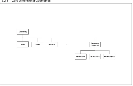
3.2.3 Zero Dimensional Geometries ... 3-35
3.2.3.1 Point Interface ... 3-35 3.2.3.2 PointFactory Interface ... 3-36 3.2.3.3 MultiPoint Interface ... 3-37 3.2.3.4 MultiPointFactory Interface ... 3-37
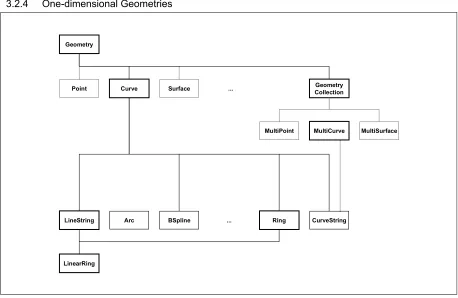
3.2.4 One-dimensional Geometries ... 3-38
3.2.4.1 Curve Interface... 3-38 3.2.4.2 LineString Interface ... 3-39 3.2.4.3 LineStringFactory Interface ... 3-40 3.2.4.4 Ring Interface... 3-41 3.2.4.5 LinearRing Interface ... 3-42 3.2.4.6 MultiCurve Interface... 3-42 3.2.4.7 MultiLineString Interface... 3-42 3.2.4.8 MultiLineStringFactory Interface... 3-42
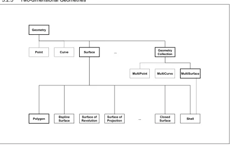
3.2.5 Two-dimensional Geometries ... 3-44
3.2.5.1 Surface Interface ... 3-44 3.2.5.2 Polygon Interface ... 3-45 3.2.5.3 LinearPolygon Interface... 3-45 3.2.5.4 LinearPolygonFactory Interface... 3-46 3.2.5.5 MultiSurface Interface ... 3-46 3.2.5.6 MultiPolygon Interface ... 3-47 3.2.5.7 MultiLinearPolygon Interface ... 3-47 3.2.5.8 MultiLinearPolygonFactory Interface ... 3-47
3.2.6 Structures & Enumerations ... 3-48
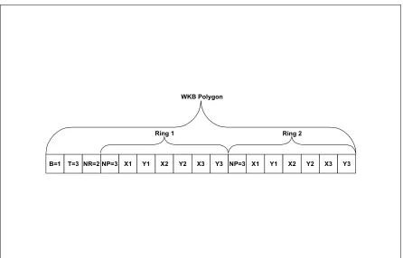
3.2.6.1 Well-known Structures... 3-48 3.2.6.2 The Well-known Binary Representation for Geometry (WKBGeometry) ... 3-49 3.2.6.3 Well-known Text Representation of Spatial Reference Systems ... 3-54
4 FEATURE IDENTITY ... 4-1
0 Preface
0.1 Submitting Companies
The following companies submitted this implementation specification in response to the OGC Request 1, Open Geodata Model Working Group, A Request for Proposals: OpenGIS Features (OpenGIS Project Document Number 96-021): Item 3 Simple Feature API for CORBA:
Bentley Systems, Inc.
Environmental Systems Research Institute (ESRI) Genasys II, Inc.
Oracle Corporation Sun Microsystems, Inc
University of California at Los Angeles (UCLA)
0.2 Submission Contact Points
All questions about this submission should be directed to: Brian Gottier
Bentley Systems, Inc. 690 Pennsylvania Drive Exton, PA 19341, USA phone: +1 610 458 5000 fax: +1 610 458 1480 email: [email protected]
David Beddoe
ESRI National Accounts 2070 Chain Bridge Rd, Suite 180 Vienna, VA 22182-2536, USA phone: +1 703 506 9515 fax: +1 703 506 9514 email: [email protected]
John Davidson Genasys II, Inc.
Middleburg, VA 22117, USA phone: +1 703 648 2490 fax: +1 703 648 2492 email: [email protected]
Dr John R Herring Oracle Corporation 196 VanBuren Street Herndon, VA 22070, USA phone: +1 703 736 8124 fax: +1 703 708 7233 email: jrherring us.oracle.com
Michael Cosentino Sun Microsystems, Inc. 901 San Antonio Rd Mail Stop MPK 15-210 Palo Alto, CA 94303, USA phone: +1 650 786 4847
email: [email protected]
Prof. Richard Muntz
UCLA Data Mining Laboratory 3277 Boelter Hall
Los Angeles, CA 90025, USA phone: +1 310 825 3546 fax: +1 310 825 2273 email: [email protected]
0.3 Document Conventions
Two different fonts have been employed to disambiguate between CORBA IDL interfaces and CORBA object instances. CORBA IDL is indicated using this font. CORBA object instances are indicated using this font.
0.4 Revision History
Revision 1.0 includes the following changes from Revision 0:
• Inserted sections 3.2.6.2 and 3.2.6.3. The source for this change was proposal #2 and #3 from Revision Request 97-400.
• Many minor cleanups made. The source for these changes was Revision Request 97-404.
Revision 1.1 includes the following changes from Revision 1.0:
• The query evaluator interface has been simplified. QueryableFeatureCollections only
allow queries on the contained features, and always return a feature collection. • The interfaces of Feature and FeatureIterator have been aligned.
1 Overview
The purpose of this specification is to provide interfaces to allow GIS software engineers to develop applications that expose functionality required to access and manipulate geospatial information comprising features with ‘simple’ geometry using OMG’s CORBA technology.
CORBA (Common Object Request Broker Architecture) provides a specification for the object-oriented distributed systems in a language, operating system, platform and vendor independent way.
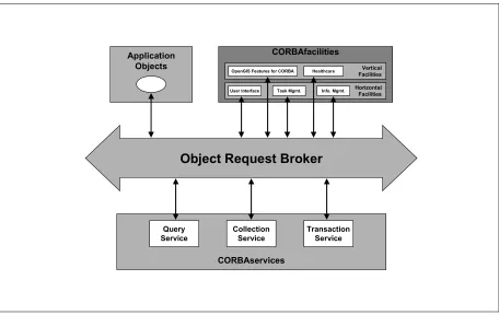
CORBA consists of a core implemented by the various commercially available ORBs (Object Request Brokers) and a number of specified object services and application facilities (CORBAservices and
CORBAfacilities). Facilities may be horizontal (provide services of a general nature to applications such as a graphic user interface or task management) or vertical (provide services targeted to a particular industry or domain). It is envisaged that this specification will become a candidate for inclusion in the OMG’s work as a vertical CORBAfacility covering geospatial information management (see Figure 1.1). More information on the OMG and CORBA may be found in [3].
In the design of this specification, the approach has been to use, where possible, existing CORBA specifications to allow leveraging of the past and present efforts of OMG and vendors of other CORBA compliant products and specifications. Where it has been deemed inappropriate, alternative specifications have been developed that follow as closely as possible existing CORBA specifications.
To use CORBA, it has been necessary to describe the abstract architecture defined in the Abstract Specification [1] in the language of CORBA’s OMA (Object Management Architecture). This has been achieved through the creation of interfaces defined in CORBA-IDL (Interface Definition Language) to represent the various OpenGIS constructs. These interfaces form two sub-systems or modules: the Feature Module and the Geometry Module.
Object Request Broker
CORBAservices
Query Service
Collection Service
Transaction Service
Application Objects
CORBAfacilities
Vertical Facilities
OpenGIS Features for CORBA Healthcare
Horizontal Facilities
User Interface Task Mgmt. Info. Mgmt.
Figure 1.1 The Architecture of OMG’s CORBA and the possible role of an OpenGIS Features for CORBA Specification.
The specification is broad enough to allow maximal flexibility in implementation. In particular, it has been designed with two implementation models is mind:
the exposure of existing (legacy) geospatial data and applications whether they be RDBMS or proprietary file repositories through some form of object ‘wrapping’.
the development of new distributed object-oriented GIS applications.
This was undertaken to ensure that the OpenGIS Interoperability specification provides a low cost entry point for existing players in the GIS marketplace while allowing a natural progression towards implementations based on the increasingly popular and powerful distributed and object-oriented technologies such as Java and the Internet. In particular, care was taken to ensure that the powerful aspects of the O-O programming paradigm were exploitable through this specification.
2 Architecture
2.1 Feature Model Architecture:
This specification employs the following model for creating, accessing and querying simple geospatial features and feature collections.
Real world entities such as “Roads” are typically represented as features comprising a set of spatial and non-spatial attribute values (e.g., a geometry such as a line string representing the road’s non-spatial extent, a string representing its name, etc.). Features may have an associated set of operations or behavior. Features are also referred to as feature instances.
System engineers categorize representations of these real world entities as feature types. A feature type defines the set of properties (and possibly behavior) that characterize features of that type. A property has a name and type. Properties may be of any (IDL) type, including simple types (shorts, longs, floats, strings etc.),
constructed types (structs, unions, sequences) and object references (including references to other features). Every feature is of primarily one type (systems using type inheritance may allow features to be of multiple types – the use of inheritance, whether single or multiple, is an implementation issue).
Feature collections are groups of features constructed for various purposes. Feature collections come in two fundamental flavors. Feature collections supporting the concept of “containment” own their constituent features i.e. the persistence of the member features is effected through the collection. If a feature is removed from its containing feature collection (without being moved to another) it ceases to exist. Other feature collections provide support for organizing and managing existing features without owning them i.e. features that are contained in other feature collections but which are grouped in some way towards a particular end: e.g. to scope a query. Features are contained in one and only one container feature collection, although they may be, by reference, members of other, non-containing, feature collections. A client’s primary access to a given feature will typically be through a feature collection.
All feature collections may also be considered to be features in their own right and may have various
associated properties and associated types. Thus, Features, may be simple or composite (Features constructed from sub-Features). This specification only covers simple (atomic) Features.
A containing feature collection must also provide clients with the various feature types it may contain on demand. This collection of feature types is the feature schema of the collection.
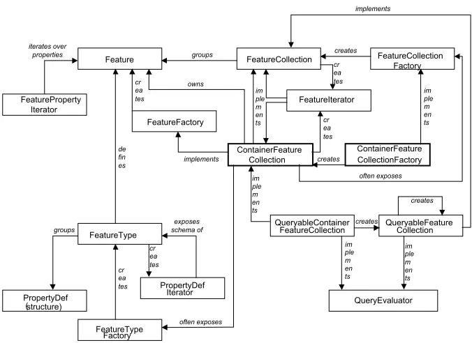
An OpenGIS Server or implementation provides the software that exposes these constructs to outside clients through specified interfaces. Figure 2.1 provides a diagrammatic representation of how the various interfaces relate to each other. A typical server application will expose a ContainerFeature-Collection
as the CORBA Naming and Trader Services (the ‘White Pages’ and ‘Yellow Pages’, respectively, of a CORBA system). A ContainerFeatureCollection is notionally equivalent to a ‘GIS database’. It contains or ‘owns’ a set of Features each which may be exposed to clients through the Feature interface. Features have a set of properties, which may be iterated over by a FeaturePropertyIterator. A FeatureType object defines the properties within this set, which is available through the Feature interface. The FeatureType object groups PropertyDef structures defining each property. These may be accessed through a PropertyDefIterator manufactured on demand by the FeatureType object.
QueryableContainer
Figure 2.1The interfaces exposing the OpenGIS Feature Model. Those in bold will typically be advertised in a naming or trader service.
Systems may enable client applications to create new Feature objects through a FeatureFactory object. Usually the ContainerFeatureCollection will assume this role. Some ContainerFeatureCollections may also expose a FeatureTypeFactory to allow client applications to create new FeatureTypes.
FeatureCollection objects may group features. ContainerFeatureCollections are a special type of
FeatureCollection: those that own their member Features. In general FeatureCollections only refer to their member Features. Such referential collections may group a sub-set of Features within a single
ContainerFeatureCollection (which may be created by a client application through a
FeatureCollectionFactory object exposed by the containing collection) or they may group Features from a number of containers. Both referential FeatureCollections and ContainerFeatureCollections may provide query functionality to clients by implementing the QueryEvaluator interface (i.e. by exposing the
QueryableFeatureCollection or QueryableContainerFeatureCollection interfaces).
Clients may issue SQL or OQL queries against these collections. The results are returned through a
QueryableFeatureCollection.
ContainerFeatureCollections through a client application using a ContainerFeatureCollectionFactory. Such objects would need to be bound to either statically or through a Naming or Trader Service.
2.2 Geometry Model Architecture
Interoperable geoprocessing requires the unambiguous exposure of geometric entities. The set of interfaces included in this proposal provides a means through which various geoprocessors may expose geometric entities to each other. The interfaces are based on the following abstract model.
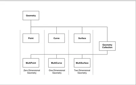
All geometric entities belong to an abstract class of ‘geometries’. All have a number of common characteristics e.g. all have spatial extent, all use some form of spatial reference system, etc.
Geometries are categorized by their dimension as zero-dimensional geometries (points), one-dimensional geometries (curves) and two-dimensional geometries (surfaces). This model can be extended to three dimensions (solids), four dimensions (hyper-solids) and higher dimensions if necessary.
These dimension-based categories are also abstract (with the exception of points). They may be further sub-divided into more specific categories with various properties which are sufficiently well constrained to be realized unambiguously by software implementations (i.e. are concrete). For example, a specific sub-set of curves called line-strings are defined by an ordered series of points with linear interpretation between points. These may be implemented in various ways by software developers and are therefore concrete.
Additionally, individual (‘simple’) geometries may be aggregated to form composite geometries or geometry collections. These geometry collections form a separate category of geometries. In general, geometry collections may be composed from geometries of different dimensionality (heterogeneous collections). Geometry collections, which comprise only geometries of a single dimension (homogenous collections), are specializations of this general type. Geometry collections may, of course, be further restricted by various implementations.
Geometry
Geometry Collection
MultiCurve Curve Point
MultiPoint MultiSurface Surface
Zero Dimensional Geometry
One Dimensional Geometry
Two Dimensional Geometry
Figure 2.2Abstract Model of OpenGIS geometry Interfaces
A Spatial Reference System may be composed of a number of components which vary in number and type depending on the type of the spatial reference system. Most SRSs abstract the shape of the earth to an ellipsoid. The mapping between this mathematical surface and the earth’s surface is defined by a horizontal datum. The ellipsoidal or geographic coordinates may be used to define geometries directly. Such an SRS is a Geographic Coordinate System. These coordinates may also be mapped from the ellipsoid to a plane using some form of projection. This mapping forms a Projected Coordinate System. Projected and Geographic Coordinate Systems are grouped in this specification as GeodeticSpatialReferenceSystems to distinguish them from other forms of SRSs described in the Abstract Specification.
3 Component
Specifications
This specification has two major components or modules: the feature module and the geometry module.
3.1 Feature Module
3.1.1 Feature Related Interfaces
3.1.1.1 Feature Interface
3.1.1.1.1 Purpose
The Feature interface is intended to give clients access to a Feature object’s instance data. It is generic: every Feature object regardless of its type conforms to this interface.
3.1.1.1.2 IDL Specification
interface PropertyDefIterator; // forward declaration interface Geometry;
interface FeaturePropertySetIterator;
interface FeatureType; // forward declaration
typedef sequence<FeatureType> FeatureTypeSeq;
typedef string Istring;
typedef sequence<Istring> IStringSeq;
// Structure to describe name-value pairs struct NVPair {
Istring name; // name is a string any value; // value is an 'any' type };
typedef sequence <NVPair> NVPairSeq;
struct FeatureData {
FeatureType type;
NVPairSeq props;
};
typedef sequence<FeatureData> FeatureDataSeq;
struct PropertyDef {
Istring name;
boolean required;
typedef sequence<WKSPoint> WKSPointSeq;
typedef sequence<WKSPoint> WKSLineString;
typedef sequence<WKSLineString> WKSLineStringSeq;
typedef sequence<WKSPoint> WKSLinearRing;
typedef sequence<WKSLinearRing> WKSLinearRingSeq;
struct WKSLinearPolygon {
WKSLinearRing externalBoundary;
WKSLinearRingSeq internalBoundaries;
};
typedef sequence <WKSLinearPolygon> WKSLinearPolygonSeq;
enum WKSType {
WKSPointType,WKSMultiPointType, WKSLineStringType,WKSMultiLineStringType, WKSLinearRingType, WKSLinearPolygonType, WKSMultiLinearPolygonType,
WKSCollectionType };
union WKSGeometry // near-equivalent to the 'CoordinateGeometry of the spec'
switch (WKSType) {
case WKSPointType:
WKSPoint point;
case WKSMultiPointType:
WKSPointSeq multi_point;
case WKSLineStringType:
WKSLineString line_string;
case WKSMultiLineStringType:
WKSLineStringSeq multi_line_string;
case WKSLinearRingType:
WKSLinearRing linear_ring;
case WKSLinearPolygonType:
WKSLinearPolygon linear_polygon;
case WKSMultiLinearPolygonType:
WKSLinearPolygonSeq multi_linear_polygon;
case WKSCollectionType:
sequence<WKSGeometry> collection;
};
exception InvalidParams {string why;};
exception InvalidProperty {}; // Not a valid property for the given feature. exception InvalidValue {}; // value is not valid for property
exception InvalidConversion {};
exception RequiredProperty {}; // property is required for the given feature
// feature type
readonly attribute FeatureType feature_type;
// geometry
Geometry get_geometry (in NVPairSeq geometry_context) raises (InvalidParams);
// generic property methods to get/set property values
boolean property_exists(in Istring name) raises(InvalidProperty);
any get_property(in Istring name) raises(PropertyNotSet,InvalidProperty);
void set_property(in Istring name, in any value)
raises(InvalidProperty, InvalidValue);
void delete_property(in Istring name) raises(PropertyNotSet, InvalidProperty, RequiredProperty);
// accessing property values by property names
string get_string_by_name(in Istring propertyName)
raises (PropertyNotSet, InvalidProperty);
float get_float_by_name(in Istring propertyName)
raises (PropertyNotSet, InvalidProperty);
double get_double_by_name(in Istring propertyName)
raises (PropertyNotSet, InvalidProperty);
long get_long_by_name(in Istring propertyName)
raises (PropertyNotSet, InvalidProperty);
short get_short_by_name(in Istring propertyName)
raises (PropertyNotSet, InvalidProperty);
boolean get_boolean_by_name(in Istring propertyName)
raises (PropertyNotSet, InvalidProperty);
Decimal get_decimal_by_name(in Istring propertyName)
raises (InvalidConversion, InvalidProperty);
OctetSeq get_byte_stream_by_name(in Istring propertyName)
raises (InvalidConversion, InvalidProperty);
Geometry get_geometry_by_name(in Istring propertyName)
raises (PropertyNotSet, InvalidProperty);
WKSGeometry get_wksgeometry_by_name(in Istring propertyName)
raises (InvalidConversion, InvalidProperty);
OctetSeq get_wkbgeometry_by_name(in Istring propertyName)
raises (InvalidConversion, InvalidProperty);
NVPairSeq get_property_sequence(in unsigned long n);
FeaturePropertySetIterator get_property_iterator();
void destroy();
};
typedef sequence<Feature> FeatureSeq;
feature_type—According to the abstract specification [1] each feature has type. This implementation specification proposes to represent type through a separate interface: FeatureType. This read only attribute gives clients access to the feature’s type information including property names and types.
get_geometry—aids in the discovery of geometric attributes. The Abstract Specification states that
features have properties, a subset of which, are geometric. A client may gain access to these geometric properties though the get_property() operation but this would require the client to either know the name of particular geometric properties or discover them through the feature’s associated
FeatureType interface. Even with this knowledge a client would need to make a choice as to which of potentially several geometric attributes it requires. The get_geometry() operation makes this process easier for clients, by allowing the server to make many of these choices on the basis of optional context information supplied to it by the client. Examples of contextual information include scale (a suitable geometric representation of a feature at 1:500 could well be different from that at 1:5000000), theme (e.g. hydrological vs. topographic) and location (e.g. a clipping polygon). The form of this context information is a name-value list (NVPairSeq). A server instance may extract and process any of the supplied context fields; the server is not required to use this information in any way. In due course, context names and semantics may need to be specified by the OGC or various GICs. A client can also use get_geometry() to retrieve a default geometric representation of a feature in a context free manner (the getDefaultGeometry() of Bentley’s first submission). get_geometry() returns a reference to a Geometry object which may be a point, curve, surface or compound geometry (collection).
property_exists—checks to see if a property is set in this list. The exception InvalidProperty
is thrown if the property is not a part of the FeatureType supported by the feature.
get_property—gets the value associated with a property name. This operation raises a
PropertyNotSet exception if the named property does not exist. An InvalidProperty
exception is thrown if the property is not a part of the FeatureType supported by the feature.
set_property—sets the named property to the supplied value. If the property is not defined (does not exist), but is a part of the feature’s property schema, then this operation creates the property. An
InvalidProperty exception is raised if the property is invalid for a given feature and an
InvalidValue exception is raised if the value is not within the valid domain of the named property.
delete_property—deletes the value of the property with the given name and sets that property to null. Raises PropertyNotSet if specified property is not defined. Raises RequiredProperty if the property is required. This operation raises an InvalidProperty exception if the property is invalid for a given feature.
Accessors—The methods of the form get_X_by_name() retrieve the data from the specified
property (by index or name) as the datatype X. An InvalidProperty is raised if the property name is. A PropertyNotSet is raised if the property is not set for the feature. The purpose of these accessors is to allow efficient retrieval of properties when the type is known, without the need to marshall the data into and out of anys.
get_property_sequence—returns at most n name-value pairs from the property set of the feature.
get_property_iterator—returns an iterator over the property set.
3.1.1.1.2 Type Specific Feature Interfaces
No subclasses of Feature are necessary but they are not precluded. An OpenGIS server may, for example, define a Road interface that inherits from Feature, and expose it to clients (through IDL or the CORBA Interface Repository). Some clients may be equipped to take advantage of the additional services the Road interface provides. Such an interface must inherit from Feature to ensure generic clients (those unable to use such specialized interfaces) may still access feature data through the generic operations described above.
3.1.1.1.3 Feature Identity
This proposal specifies that the identity of a Feature is encapsulated into its object reference. This policy is provided for in CORBA by the upcoming Portable Object Adapter specification [2]. For a discussion of these issues see Section 4.
3.1.1.1.4 Typical Server Implementations
Typically in object-oriented environments GIS features are implemented as objects. The Feature
interface will be a thin wrapper over these feature objects. The get_property() and set_property() operations will retrieve and modify these objects’ internal properties. The implementation of the
FeatureType attribute will typically be a class object. The get_geometry() method scans the Feature’s property list for all properties which have “Geometry” TypeCode.
In RDBMSs, GIS features are typically represented as rows in various relational tables. The feature interface will allow access to the tuples within a particular row. The get_property() and
set_property() operations will probably be effected by the submission of appropriate SQL calls. The underlying implementation of the FeatureType attribute will typically be a row in a system table. The table name and primary key of the row will be encoded by the server into the Feature’s object reference.
3.1.1.1.5 Client Scenarios
Assume that a generic ‘feature browser’ client retrieved a Feature interface reference from a
FeatureIterator (see Section 3.1.3.3). It could use the following algorithm to display the features geometric and non-geometric properties in some sort of form display:
// generic client pseudocode
Feature featureRef;
FeatureType featureTypeRef;
CORBA_Any propertyValue;
PropertyDefSeq propertySet;
...
// get FeatureType reference
featureTypeRef = featureRef.get_feature_type();
// get Property Names from feature type reference propertySet = featureTypeRef.get_property_defs();
for ( i=0; i< propertySet.length; i++) { // for each property ...
try {
propertyValue = featureRef.get_property((propertySet.get(i)).name);
if (isGeometry(propertyValue.type)
drawInGraphicsWindow (propertyValue.value);
else
writeInTextWindow (propertyValue.value);
// ... exception handling } catch (PropertyNotSet) { // ... exception handling }
}
The details of get_property_defs() function is explained under FeatureType (Section 3.1.2). Note that this client uses CORBA any types, which contain type information. The client can test what type of information is contained in an any and act in an appropriate manner: in this case deciding between graphic and non-graphic output. A more sophisticated client may use this type information to determine the layout of a form-based dialog. This type information is also available from the FeatureType reference so the client may get an array of property types with the array of property names and directly cast the any to a variable of the appropriate type.
A dedicated client (one that is familiar with the server’s type system) may also use the generic interface to retrieve data.
// dedicated client (generic interface) pseudocode
Feature featureRef;
FeatureType featureTypeRef;
CORBA_Any propertyValue String roadName;
Geometry roadCentreLine;
...
// get FeatureType reference
if (strcmp(featureRef.get_feature_type().name(),“RoadType”) == 0)
try {
// get Road name
propertyValue = featureRef.get_property(“road_name”);
roadName = (String)propertyValue.value;
// get Road centreLine
propertyValue = featureRef. get_property(“centre_line”);
roadCentreLine = (Geometry)propertyValue.value;
} catch (InvalidPropertyName) { // ... exception handling }
}
This code only differs from the above in that the client already knows what properties a ‘Road’ feature will have. (There are many cases where clients can be expected to have this sort of knowledge: it may use a GIC standard; use a published IDL type schema or be an in-house solution based on commercial OpenGIS compliant software.) Such a client is, however, not restricted to using this generic interface:
// dedicated client (type-specific interface) pseudocode
Feature featureRef;
FeatureType FeatureTypeRef;
Road roadRef;
String roadName;
Geometry roadCentreLine;
...
// get FeatureType reference
This code will provide more performance because the switching into and out of any types has been eliminated. This is achieved at the cost of generality.
3.1.1.1.6 Rejected Approaches
Requiring the representation of all features as type-specific interfaces and its attendant requirement to insert feature type details into the Interface Repository as proposed in Bentley’s first submission has been rejected on the grounds of placing unreasonable obligations on both server and client implementations. See the discussion under FeatureType interface for further details.
The UCLA proposal to only provide feature data through a ‘GIS_Iterator’ without persistence or identity was also rejected on the grounds of having insufficient power to fulfill the functional requirements of RFP 1.
3.1.1.2 FeaturePropertySetIterator Interface
3.1.1.2.1 Purpose
The FeaturePropertyIterator interface provides support for iterating through a given Feature object’s property set. The factory of a FeaturePropertyIterator instance is a Feature object.
3.1.1.2.2 IDL Specification
interface FeaturePropertySetIterator {
exception IteratorInvalid {};
// Get next NVPair structure boolean next(out NVPair the_pair)
raises (IteratorInvalid);
// Get next "n" NVPair structures. boolean next_n(in unsigned long n,
out NVPairSeq n_pairs)
raises (IteratorInvalid);
// Discard the iterator void destroy();
// reset the iterator
void reset() raises (IteratorInvalid);
};
3.1.1.2.3 Interface Description
next—retrieves the next property name-value pair. The order of retrieved properties is implementation dependent. This operation returns true if a valid property was placed in the_pair and false if there are no more properties to retrieve. An IteratorInvalid exception is raised if the iterator has become invalid.
next_n—retrieves the next n property name-value pairs. If less than n properties are available, then all remaining pairs are retrieved. This operation returns true if a sequence of properties was placed in
destroy—destroys the iterator object.
reset—resets the iterator to the first property of the set. An IteratorInvalid exception is raised if the iterator has become invalid.
3.1.1.3 FeatureFactory Interface
3.1.1.3.1 Purpose
The FeatureFactory provides support for the creation of a Feature instance of a given FeatureType.
3.1.1.3.2 IDL Specification
interface FeatureFactory {
exception FeatureTypeInvalid {string why;};
exception PropertiesInvalid {string why;};
Feature create_feature(in FeatureType type, in NVPairSeq properties)
raises (FeatureTypeInvalid, PropertiesInvalid);
FeatureSeq create_features(in FeatureDataSeq features)
raises (FeatureTypeInvalid, PropertiesInvalid);
};
3.1.1.3.3 Interface Description
create_feature—creates a new Feature instance of the desired type (i.e., the FeatureType
argument). A FeatureTypeInvalid exception is thrown if the supplied FeatureType is not supported by the FeatureFactory instance. A PropertiesInvalid exception is thrown if the arguments supplied for the Feature object of the given FeatureType are incorrect or insufficient (i.e., the required set of parameters is not supplied).
create_features—creates a set of new Feature instances of the desired type (i.e., the
FeatureType argument). A FeatureTypeInvalid exception is thrown if the supplied
FeatureType is not supported by the FeatureFactory instance. A PropertiesInvalid exception
is thrown if the arguments supplied for a given Feature object of the given FeatureType are incorrect or insufficient (i.e., the required set of parameters is not supplied).
3.1.2 Feature Type Related Interfaces
3.1.2.1 FeatureType Interface
3.1.2.1.1 Purpose
The FeatureType interface is intended to provide details of the type of a Feature that are described as ‘Feature Schema’ in the Abstract Specification’s Essential Model, specifically the names and types of the properties associated with each instance of a Feature of the given FeatureType.
3.1.2.1.2 IDL Specification
interface FeatureType {
exception PropertyDefInvalid {};
// feature type name
readonly attribute Istring name;
// feature type parents
FeatureTypeSeq get_parents() raises (InheritanceUnsupported);
// feature type children
FeatureTypeSeq get_children()raises (InheritanceUnsupported);
// definition of properties for this feature type
boolean property_def_exists(in Istring name);
PropertyDef get_property_def(in Istring name) raises(PropertyDefInvalid);
PropertyDefSeq get_property_def_sequence(in long levels, in unsigned long n);
PropertyDefIterator get_property_def_iterator (in long levels);
void destroy();
};
typedef sequence<FeatureType> FeatureTypeSeq;
3.1.2.1.3 Interface Description
name—a string naming the feature type. This will typically correspond to a table name in an RDBMS and a class name in an OO environment.
get_parents—returns a sequence of FeatureTypes which represent the direct ancestors of the FeatureType. The return sequence will be empty if the implementation the FeatureType is a root type. The sequence will have no more than one member if the implementation supports only single inheritance. Implementations supporting multiple inheritance will return an arbitrary length sequence. Implementations that do not support inheritance will raise an InheritanceUnsupported
exception.
get_children—returns a sequence of FeatureTypes which represent the children of the FeatureType. The return sequence will be empty if the FeatureType has no children. Implementations that do not support inheritance will raise an InheritanceUnsupported
exception.
property_def_exists—returns true if a property named name is defined.
get_property_def— returns the PropertyDef structure associated with the property name.
get_property_def_sequence—returns a sequence of at most n property definitions. The levels
parameter indicates how many levels of the type hierarchy should be searched for inherited properties. A value of 0 indicates only properties defined by this FeatureType explicitly should be returned. A value of 1 indicates properties from this FeatureType and its immediate parent(s) should be returned. A value of –1 indicates that the all properties should be returned regardless of the depth of the inheritance tree. This value is ignored by implementations that do not support inheritance.
get_property_def_iterator—returns an iterator over the schema of the FeatureType.
destroy—destroys the FeatureType instance.
3.1.2.1.4 Conceptual framework
3.1.2.1.5 Feature Polymorphism
A Feature is of one and only one principal type. The FeatureType referred by the Feature’s
feature_type property is its principal type. If the implementation supports inheritance (either single or multiple), a Feature may inherit properties (and behavior) from parent types.
3.1.2.1.6 Typical Server Implementations
Typically in object-oriented environments a class or factory object embodies object type. These objects are obvious candidates for the implementation of the FeatureType interface. They have identity, property (and method) signatures, support polymorphism and are used by the memory management system when creating new objects.
In RDBMSs, the FeatureType corresponds most closely with the data definition (schema) of a relational table. Tables also have identity (based on table name) and a set of properties or columns (retrievable from a row in a system table or data dictionary). The table name is also used in the SQL insert statement when creating a new row in the table (a new feature instance). Tables have no standard way of addressing polymorphism or feature behavior but these are not required for OpenGIS compliance.
3.1.2.1.7 Rejected Approaches
Including methods to retrieve feature type from the Feature interface directly was considered. This may have taken the form of a get_schema() operation. This was rejected on the grounds that such a identity-free approach to feature type would significantly diminish the power of the specification.
3.1.2.1.8 Feature Behavior & the Interface Repository
Discussions at various OpenGIS fora have indicated that the Abstract Specification’s notion of a “property set” includes a set of operations defining the behavior of features of a particular type. This proposal excludes operations from the schema provided through the FeatureType interface. This is a pragmatic policy: CORBA already has a well-defined mechanism for the dynamic discovery of behavior: the Interface Repository (IR). In fact, the IR could be used in place of the FeatureType interface to expose all properties as well as behavior, but it was considered overly onerous to require all OpenGIS servers to provide IR definitions for all FeatureTypes.
It should be noted, however, that it is likely to become easier for server developers to offer such services as the vendor community provides increasingly comprehensive development tools in the CORBA
environment. For example, a tool to automatically generate IR entries from data dictionaries in an RDBMS would remove most of the development effort of the IR approach for server implementers exposing RDBMS data and metadata. If such tools become sufficiently powerful, the FeatureType interface may be deprecated.
Server developers prepared to offer feature behavior might include IR entries for each type-specific Feature interface to allow dynamic discovery of behavior. A client able to dynamically discover and utilize feature behavior will use the IR to obtain details of available functionality (using the get_interface()
operation which the Feature interface inherits from CORBA_Object). If the response to
get_interface() is the Feature interface the client can assume that no feature behavior is available and that property set information is only obtainable through the FeatureType interface. Clients unable to dynamically discover feature behavior will always use the FeatureType interface. To ensure such clients can always access property information, all OpenGIS compliant servers must provide a
3.1.2.2 FeatureTypeFactory Interface
3.1.2.2.1 Purpose
The FeatureTypeFactory interface provides support for the creation of FeatureType object
instances.
3.1.2.2.2 IDL Specification
interface FeatureTypeFactory {
exception InvalidParams {string why;};
FeatureType create(in string name, in PropertyDefSeq schema,
in FeatureTypeSeq parents)
raises(InvalidParams); };
3.1.2.2.3 Interface Description
create—creates a FeatureType instance given a type name, attribute schema, and lists of parents of the FeatureType. Raises an InvalidParams exception if any of the supplied arguments are invalid.
3.1.2.3 PropertyDefIterator Interface
3.1.2.3.1 Purpose
The PropertyDefIterator interface provides support for iterating over a FeatureType’s property definitions or schema. The factory of a PropertyDefIterator instance is a FeatureType object.
3.1.2.3.2 IDL Specification
interface PropertyDefIterator {
exception IteratorInvalid {};
// Get next PropertyDef structure
boolean next(out PropertyDef schema_property)
raises (IteratorInvalid);
// Get next "n" PropertyDef structures boolean next_n(in unsigned long n,
out PropertyDefSeq schema_properties)
raises (IteratorInvalid);
// Discard the iterator void destroy();
// reset the iterator
void reset() raises (IteratorInvalid);
};
3.1.2.3.3 Interface Description
next—retrieves the next property definition. This operation returns true if a property was placed in
schema_property and false if there are no more property definitions to retrieve. An
next_n—retrieves the next n schema attributes. If less than n attributes are available, then retrieves all those remaining. This operation returns true if a sequence of property definitions was placed in
schema_properties and false if there are no more property definitions to retrieve. An
IteratorInvalid exception is raised if the iterator has become invalid.
destroy—deletes the iterator object.
reset—resets the iterator to the first schema attribute of the set. An IteratorInvalid exception is raised if the iterator has become invalid.
3.1.3 Feature Collection Related Interfaces
3.1.3.1 Feature Collection Interface
3.1.3.1.1 Purpose
This interface provides services for the management of groups of OpenGIS features. These groups can come into being for a number of reasons: e.g. a project as a whole, for the scope of a query, as the result of a query or arbitrarily selected by a user for some common manipulation. A feature’s membership of a particular FeatureCollection does not necessarily imply any relationship with other member features. Composite or compound features which ‘own’ constituent member Features (e.g. an Airport composed of Terminals, Runways, Aprons, Hangars, etc) may also support the FeatureCollection interface to provide a generic means for clients to access constituent members without needing to be aware of the internal implementation details of the compound feature. Compound features are not specified in this proposal.
3.1.3.1.2 IDL Specification
interface FeatureIterator; // forward declaration
interface FeatureCollection : Feature {
exception IteratorInvalid {};
exception PositionInvalid {};
exception FeatureInvalid {string why;};
exception PropertiesInvalid {string why;};
readonly attribute long number_features;
FeatureTypeSeq supported_feature_types();
void add_element (in Feature element) raises (FeatureInvalid);
void merge (in FeatureCollection elements) raises (FeatureInvalid);
void insert_element_at (in Feature element, in FeatureIterator where)
raises (FeatureInvalid, IteratorInvalid);
void replace_element_at (in Feature element, in FeatureIterator where)
raises (FeatureInvalid, IteratorInvalid, PositionInvalid);
void remove_element_at (in FeatureIterator where)
raises (IteratorInvalid, PositionInvalid);
void remove_all_elements ();
Feature retrieve_element_at (in FeatureIterator where) raises (IteratorInvalid, PositionInvalid);
FeatureIterator create_iterator();
3.1.3.1.3 Interface Description
Feature Interface inheritance—This interface inherits from the Feature interface. This approach is in line with the Abstract Specification that allows feature collections to be defined as features [1, paragraph 3.13.1.4]. FeatureCollections, thus, have persistence and identity mechanisms identical to those of Features. In the FeatureCollection context, the property set is constituted by attributes of the collection as a whole rather than single member Features. The specification of property types and names will, as with features, be the province of system implementers and GICs. These details will be available to clients through the FeatureCollection’s associated FeatureType object. The
implementation of the get_geometry() method will also be server dependent: it may return the collection of all features’ geometries or a generalized representation of the feature collection as a whole. This allows clients which simply require a geometric representation of the collection for review (e.g. a topographic reference for thematic maps) to retrieve it directly from the collection without dealing with individual features. As part of a schema definition for a FeatureCollection instance, a user may have a property like “SupportedFeatureTypes”, which the user can query to find out what FeatureTypes the given collection supports. The destroy() operation destroys the FeatureCollection instance. In general, the FeatureCollection’s elements are not destroyed by this operation.
number_features—this attribute identifies the number of Features within the FeatureCollection.
supported_feature_types—this method returns the type description of all feature types supported
by the FeatureCollection.
add_element—adds the Featureelement to the FeatureCollection. If element does not adhere to all membership restrictions of the FeatureCollection a FeatureInvalid exception is raised.
merge—merges the FeatureCollectionelements into the FeatureCollection. If a component of
elements does not adhere to the membership restrictions of the FeatureCollection a
FeatureInvalid exception is raised.
insert_element_at—inserts the Featureelement at the position in the FeatureCollection
indicated by the FeatureIteratorwhere. A FeatureInvalid exception is raised if element does not conform to the membership requirements of the FeatureCollection. An IteratorInvalid
exception is raised if where is not a valid iterator of the FeatureCollection. A PositionInvalid
exception is raised if the iterator is not pointing at a Feature.
replace_element_at—replaces the Featureelement at the position in the FeatureCollection
indicated by the FeatureIteratorwhere. A FeatureInvalid exception is raised if element does not conform to the membership requirements of the FeatureCollection. An IteratorInvalid
exception is raised if where is not a valid iterator of the FeatureCollection. A PositionInvalid
exception is raised if the iterator is not pointing at a Feature.
remove_element_at—removes the Feature at the position in the FeatureCollection indicated by the FeatureIteratorwhere. An IteratorInvalid exception is raised if where is not a valid iterator of the FeatureCollection. A PositionInvalid exception is raised if the iterator is not pointing at a Feature.
remove_all_elements—empties the FeatureCollection.
create_iterator—returns a FeatureIterator which may be used to access Feature objects and data.
3.1.3.1.4 Typical Server Implementations
In an OO environment there are various numbers of possible implementations of FeatureCollections which group object references together. These include arrays, linked lists, binary or B-trees, hash tables, etc. The separation of FeatureCollection from FeatureIterator hides these implementation details from clients.
In an RDBMS, a FeatureCollection will typically be implemented as a table or view.
3.1.3.2 FeatureCollectionFactory Interface
3.1.3.2.1 Purpose
The FeatureCollectionFactory interface provides support for the creation of FeatureCollection
object instances.
3.1.3.2.2 IDL Specification
interface FeatureCollectionFactory {
exception FeatureTypeInvalid {string why;}; exception PropertyInvalid {string why;}; exception FeatureInvalid {string why;};
FeatureCollection create(in FeatureType collection_type,
in NVPairSeq collection_properties,
in FeatureTypeSeq supported_feature_types)
raises (FeatureTypeInvalid, PropertyInvalid);
FeatureCollection createFromCollection(in FeatureType collection_type, in NVPairSeq collection_properties,
in FeatureTypeSeq supported_feature_types,
in FeatureCollection collection)
raises (FeatureTypeInvalid,PropertyInvalid,FeatureInvalid);
FeatureCollection createFromSequence(in FeatureType collection_type,
in NVPairSeq collection_properties,
in FeatureTypeSeq supported_feature_types,
in FeatureSeq list)
raises (FeatureTypeInvalid,PropertyInvalid,FeatureInvalid);
};
3.1.3.2.3 Interface Description
create—creates a FeatureCollection instance given the FeatureType of the collection and a set of collection properties, and a list of valid feature types that are supported by the collection. Raises a
FeatureTypeInvalid exception if the supplied FeatureType instance is invalid. A
PropertyInvalid exception is raised if the required collection parameters are not supplied.
createFromCollection—create a FeatureCollection instance given the FeatureType of the
collection, a set of collection properties, a list of valid feature types that are supported by the collection, and a FeatureCollection instance from which to copy Feature instance references. Raises a
FeatureTypeInvalid exception if the supplied FeatureType instance is invalid. A
FeatureInvalid exception is raised if the supplied Feature instances do not adhere to the collection’s membership restrictions, if any.
createFromSequence—create a FeatureCollection instance given the FeatureType of the
collection, a set of collection properties, a list of valid feature types that are supported by the collection, and a sequence of Feature instances. Raises a FeatureTypeInvalid exception if the supplied FeatureType instance is invalid. A PropertyInvalid exception is raised if the required collection parameters are not supplied. A FeatureInvalid exception is raised if the supplied Feature
instances do not adhere to the collection’s membership restrictions, if any.
3.1.3.3 FeatureIterator Interface
3.1.3.3.1 Purpose
This interface provides clients with the ability to access feature data through a FeatureCollection object. FeatureCollections act as factories for FeatureIterators. This interface allows OpenGIS servers to expose Feature data without requiring the exposure of persistent Feature objects to CORBA clients. The process of CORBA Object creation may be expensive: this iterator allows the service to provide data for multiple features through a single CORBA Object.
3.1.3.3.2 IDL Specification
interface FeatureIterator {
exception IteratorInvalid {}; exception PositionInvalid {}; exception FeatureNotAvailable {};
exception InvalidConversion {}; exception InvalidProperty {};
exception PropertyNotSet {};
exception InvalidParameters {};
// iterating over features
boolean next (out Feature the_feature) raises (IteratorInvalid, PositionInvalid, FeatureNotAvailable);
boolean next_n (in short n, out FeatureSeq the_features) raises (IteratorInvalid, PositionInvalid,
FeatureNotAvailable);
void advance ()
raises (IteratorInvalid, PositionInvalid);
Feature current ()
raises (IteratorInvalid, PositionInvalid,
FeatureNotAvailable);
// accessing current feature via ‘Feature’-like methods FeatureType get_feature_type();
Geometry get_geometry(in NVPairSeq geometry_context) raises (InvalidParameters);
boolean property_exists(in Istring name) raises(InvalidProperty);
any get_property(in Istring name) raises (PropertyNotSet,
InvalidProperty,);
string get_string_by_name(in Istring propertyName)
raises (PropertyNotSet, InvalidProperty);
float get_float_by_name(in Istring propertyName)
double get_double_by_name(in Istring propertyName)
raises (PropertyNotSet, InvalidProperty);
long get_long_by_name(in Istring propertyName)
raises (PropertyNotSet, InvalidProperty);
short get_short_by_name(in Istring propertyName)
raises (PropertyNotSet, InvalidProperty);
boolean get_boolean_by_name(in Istring propertyName)
raises (PropertyNotSet, InvalidProperty);
Decimal get_decimal_by_name(in Istring propertyName)
raises (InvalidConversion, InvalidProperty);
OctetSeq get_byte_stream_by_name(in Istring propertyName)
raises (InvalidConversion, InvalidProperty);
Geometry get_geometry_by_name(in Istring propertyName)
raises (PropertyNotSet, InvalidProperty);
WKSGeometry get_wksgeometry_by_name(in Istring propertyName)
raises (InvalidConversion, InvalidProperty);
OctetSeq get_wkbgeometry_by_name(in Istring propertyName)
raises (InvalidConversion, InvalidProperty);
NVPairSeq get_property_sequence(in unsigned long n);
FeaturePropertySetIterator get_property_iterator();
void reset() raises (IteratorInvalid);
boolean more();
void destroy();
};
3.1.3.3.3 Interface Description
current—returns a reference to a persistent CORBA object conforming to the Feature interface and
representing the Feature at the iterator’s current position. This operation raises a PositionInvalid
exception if the iterator is not pointing to a valid Feature. It raises a FeatureNotAvailable
exception if the server does not support the provision of persistent CORBA object references to its Features. The operation raises a IteratorInvalid exception if the iterator is no longer valid: this will probably be due to operations on its underlying collection since the iterator was created (eg. additions and deletions to and from the FeatureCollection).
next—moves the iterator’s internal pointer to the next Feature and retrieves a reference to a persistent CORBA object conforming to the Feature interface and representing that Feature. This operation returns true if a valid Feature reference was placed in the_feature and false if there are no more Features to retrieve. An IteratorInvalid exception is raised if the iterator has become invalid. This operation is functionally equivalent to an advance() invocation followed by a current()
invocation. next() raises the same exceptions as current(). The order in which features are returned is implementation dependent. Consecutive calls to next() will retrieve each Feature within in the collection exactly once.
next_n—retrieves the next n Features as a sequence of CORBA object references and moves the
advance—moves the iterator’s internal pointer to the next Feature. Subsequent calls to retrieve properties will operate on the Feature at the current position.
Feature Property Access—the FeatureIterator interface provides the user with the ability to retrieve properties of the Feature at the current iterator position. Generic operations include
get_feature_type, get_property_by_name, and get_geometry.
get_property_by_name—returns the named property’s data. The get_property_sequence
and get_property_iterator operations provide clients with the ability to request the
Feature’s properties as a sequence or to get an iterator over the property set. These operations are functionally identical to their equivalents in the Feature interface and raise exceptions if the same manner.
reset—this method resets the iterator’s internal pointer to the first Feature in the collection. This method will also revalidate an invalid iterator. Which Feature is deemed to be first is implementation dependent. an IteratorInvalid exception is raised if the iterator has become invalid.
more—returns TRUE if there are more features after the current Feature and FALSE otherwise.
destroy—deletes the FeatureIterator instance.
3.1.3.3.2 Typical Server Implementations
The separation of the FeatureIterator operations from the FeatureCollection interface allows client applications to deal with various implementations of FeatureCollections in a generic way.
FeatureIterators will, in general be closely coupled with their associated FeatureCollections
which act as factories for iterators. For example, in an OO environment where a FeatureCollection
is implemented as a linked list, the FeatureIterator would be a wrapper around a pointer to the ‘current’ feature.
In an RDBMS, where a FeatureCollection is often implemented as a table or view, the
FeatureIterator will typically be a cursor.
3.1.4 Container Feature Collection Interfaces
3.1.4.1 ContainerFeatureCollection Interface
3.1.4.1.1 Purpose
Typically a FeatureCollection groups its member Features by maintaining a list of references. A
ContainerFeatureCollection’s elements are entirely created and owned by it. The Features belong
logically to the ContainerFeatureCollection, not just referred to by it. Therefore, a ContainerFeatureCollection acts as a factory for FeatureTypes that it supports. In addition, a feature added via methods like add_element() is deep-copied i.e., a new feature of the given type is created by the ContainerFeatureCollection.
3.1.4.1.2 IDL Specification
interface ContainerFeatureCollection : FeatureCollection, FeatureFactory { };
FeatureCollection Interface inheritance—The ContainerFeatureCollection interface also inherits
the FeatureCollection interface for membership access and manipulation. However, it
specializes the implementation of some of these methods with “ownership” semantics rather than referential semantics (see below). The destroy() method destroys the ContainerFeatureCollection instance. All of the ContainerFeatureCollection’s elements aredestroyed by this operation.
add_element—adds the feature element to the ContainerFeatureCollection. If element does not adhere to all membership restrictions a FeatureInvalid exception is raised. Otherwise, a deep copy of the Feature is performed, and a new Feature object is created.
merge—merges the FeatureCollection’s elements into the ContainerFeatureCollection. If a component of elements does not adhere to the membership restrictions of the ContainerFeature-Collection a FeatureInvalid exception is raised. Otherwise, a deep copy of each element Feature of the FeatureCollection is performed, and a new Feature object is created for every element.
insert_element_at—inserts the Featureelement at the position in the
ContainerFeatureCollection indicated by the FeatureIteratorwhere. A FeatureInvalid
exception is raised if element does not conform to the membership requirements of the
ContainerFeatureCollection. An IteratorInvalid exception is raised if where is not a valid iterator of the ContainerFeatureCollection. Otherwise, a deep copy of the Feature is performed, and a new Feature object is created.
replace_element_at—replaces the Featureelement at the position in the
ContainerFeatureCollection indicated by the FeatureIteratorwhere. A deep copy of the Feature is performed, and a new Feature object is created to replace the Feature located at the position indicated by the iterator. The old Feature is destroyed. A FeatureInvalid exception is raised if element
does not conform to the membership requirements of the FeatureCollection. An
IteratorInvalid exception is raised if where is not a valid iterator of the FeatureCollection. A
PositionInvalid exception is raised if the iterator is not pointing at a Feature.
remove_element_at—removes the Feature at the position in the ContainerFeatureCollection
indicated by the FeatureIteratorwhere. A successful invocation of this operation will result in the destruction of the Feature object. An IteratorInvalid exception is raised if where is not a valid iterator of the ContainerFeatureCollection. A PositionInvalid exception is raised if the iterator is not pointing at a Feature.
remove_all_elements—empties the ContainerFeatureCollection and deletes all member
Features.
retrieve_element_at—returns the Feature at the position in the ContainerFeatureCollection
indicated by the FeatureIteratorwhere. An IteratorInvalid exception is raised if where is not a valid iterator of the ContainerFeatureCollection. A PositionInvalid exception is raised if the iterator is not pointing at a Feature.
FeatureFactory inheritance—create_feature() and create_features() create new Feature instances of the desired type (i.e., the FeatureType argument). A FeatureTypeInvalid
exception is thrown if the supplied FeatureType is not a member of the collection’s supported
FeatureTypes. A PropertiesInvalid exception is thrown if the arguments supplied for the
Feature object(s) of the given FeatureType are incorrect or insufficient (i.e., the required set of parameters is not supplied). The ContainerFeatureCollection wholly owns the resultant features.
The ContainerFeatureCollection, as the interface exposing creation and deletion of features will typically be implemented by the module of an application responsible for maintaining the resources required to store feature data. In an OO system this may be some form of persistent object storage (such as a file system or an integration mechanism responsible for pulling data into and out of an underlying RDBMS server). In an RDBMS implementation the ContainerFeatureCollection will typically be a wrapper over a table or a series of tables.
3.1.4.2 ContainerFeatureCollectionFactory Interface
3.1.4.2.1 Purpose
The ContainerFeatureCollectionFactory interface provides support for the creation of
ContainerFeatureCollection object instances. Clients will typically gain access to such factories through a naming or trading service.
3.1.4.2.2 IDL Specification
interface ContainerFeatureCollectionFactory {
exception FeatureTypeInvalid {string why;};
exception PropertyInvalid {string why;};
exception FeatureInvalid {string why;};
ContainerFeatureCollection create(in FeatureType collection_type,
in NVPairSeq collection_properties)
raises (FeatureTypeInvalid, PropertyInvalid);
ContainerFeatureCollection createFromCollection(in FeatureType collection_type,
in NVPairSeq collection_properties,
in FeatureCollection collection)
raises (FeatureTypeInvalid,PropertyInvalid,FeatureInvalid);
ContainerFeatureCollection createFromSequence(in FeatureType collection_type,
in NVPairSeq collection_properties,
in FeatureSeq list)
raises (FeatureTypeInvalid,PropertyInvalid,FeatureInvalid);
ContainerFeatureCollection createFromFeatureData(in FeatureType collection_type, in NVPairSeq collection_properties, in FeatureDataSeq list)
raises (FeatureTypeInvalid,PropertyInvalid,FeatureInvalid);
};
3.1.4.2.3 Interface Description
create—creates a ContainerFeatureCollection instance given the FeatureType of the collection and a set of collection properties. Raises a FeatureTypeInvalid exception if the supplied FeatureType is invalid. A PropertyInvalid exception is raised if the required collection parameters are not supplied.
createFromCollection—creates a ContainerFeatureCollection instance given the FeatureType